

- About Us
- Information
-

The Author ensures that the research has been conducted responsibly and ethically with adherence to all relevant regulations. read more..
- For Authors
- For Reviewer
- Manuscript Guidelines
- Membership
- Publication Ethics
-
- Journals
- Reprints
- e-Books
- Videos
- Policies
- Contact Us
 COVID-19
- Submissions



Full Text
Aspects in Mining & Mineral Science
Espinhaço Mountain Range: We Were One, and Now We Are Two?
Almeida Abreu PA* and Fraga LMS
Postgraduate Program in Geology (PPGGeo), ICT - Federal University of Jequitinhonha and Mucuri Valleys, Brazil
*Corresponding author:Pedro Angelo Almeida-Abreu, Postgraduate Program in Geology (PPGGeo), ICT - Federal University of Jequitinhonha and Mucuri Valleys, Diamantina/MG, Brazil
Submission: June 30, 2026: Published: August 07, 2026
ISSN 2578-0255Volume15 Issue 3
Abstract
Brazil’s only mountain range rises in a north-south direction for 1200km and, although segmented in the north-central part of the state of Minas Gerais, remained unbroken as a sedimentary basin until the Stenian period, when a tectonic inversion occurred due to the collision of a continental block from the east. The continental collision led to the formation of an orogen, and the associated directional faulting caused the orogen to rupture, irreversibly displacing the southern segment to the NW. The protruding orogen compelled the arching of the crust on its western front following the advance of tectonic stacking, where the foreland basin represented by the Conselheiro Mata Group was established. The five formations of this group alternate between pelitic sedimentation from shallow marine environments and sandy sedimentation from beach and coastal environments, an alternation that marks tectonic pulses with subsidence events versus silt-up due to progradation. The orogenic edifice, being so tall, surpassed the altitudes of the snow line, becoming a disperser of glaciers, which recorded rocks then exposed in the upper parts of the mountain range in their glacial deposits. Terminal moraines promoted the amalgamation of the two segmented parts with tillites that do not present clasts of rocks from the Pedro Lessa Suite (~920-906Ma), thus referring the Jequitaí Glaciation to the end of the Mesoproterozoic (therefore, the first post-Huronian glaciation). The glaciogenic fringes surrounding the termination of both segments of the Serra do Espinhaço testify that the mountain range was already segmented, and since the Jequitaí glaciation is of the alpine type, that the two segments of the mountain range were already orogenic entities.
Keywords:Espinhaço mountain range; Mesoproterozoic orogeny; 1Ga jequitaí glaciation
Introduction
We recently presented this article at “Geoprovocações-2026” (Geoprovocations-2026), a local symposium promoted by the undergraduate course in Geological Engineering at UFVJM. This is a compelling topic, given the historical controversy surrounding the geology of the Serra do Espinhaço (SdE - Espinhaço mountain range) regarding its geodynamic evolution, that is, whether it was a sag-basin or a passive continental margin and when the tectonic inversion occurred, whether in the Mesoproterozoic or at the end of the Neoproterozoic. Additionally, the glaciogenic deposits that make up the fringes around the orographic entities of the SdE have also been the subject of controversy, considering propositions that they are deposits from a continental glaciation versus mountain glaciation deposits, related to the Sturtian glaciation of the Cryogenic period, or whether it would be a glaciation of the end of the Mesoproterozoic (~1Ga, Jequitaí Glaciation), in which case, marking a sui generis event, being then the first post-Huronian glaciation. In this synthesis article, we present geological data from the SdE that indicate geodynamic evolution from a rift established at approximately 1.75Ga, to a passive continental margin at approximately 1.7Ga, tectonic inversion initiated at approximately 1.5Ga, and the tectonic paroxysm at approximately 1.3Ga with the formation of its foreland basin and, at the end of the Mesoproterozoic, the SdE becoming the center of glacier dispersal of an Alpine-type glaciation.
Geological Context
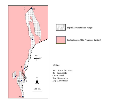
The SdE constitutes the only mountain range in Brazil, extending 1200km in a north-south direction and, although segmented in the north-central region of the state of Minas Gerais (Figure 1), it remained a whole integral sedimentary basin until the Stenian period, when its tectonic inversion occurred due to the collision of a continental block coming from the east. Pioneering geological studies on the SdE refer to Eschwege [1,2] & Derby [3] among many other works from the first half of the 20th century. In fact, the consolidation of knowledge of the geology of the SdE was boosted by the work of Pflug and collaborators between the 1960s and 1980s (see Pflug et al. [4-7]). The evolution of geological knowledge and concepts regarding the geology of the SdE can be found in Renger et al. [8,9]. From the last decade of the 20th century to the present day, controversies surrounding the geological environments of the SdE have intensified, particularly regarding the type and evolution of the basin, as well as the age of the deformation that built the mountain range, as well as the type and age of the Proterozoic glaciation of the glaciogenic deposits that occur around the SdE.
Figure 1:The Espinhaço mountain range with its two segments. The southern part, located on the edge of the craton, represents an ancient continental margin and the northern part an aborted rift aulacogen.
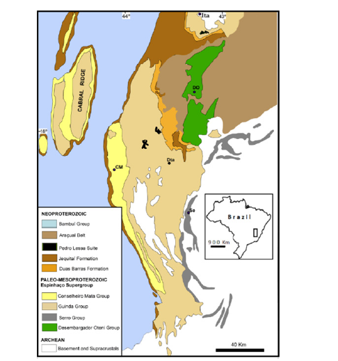
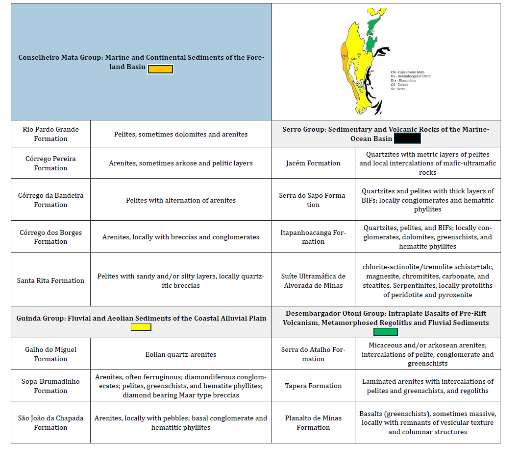
The southern segment of the Espinhaço Mountain Range (SdEM, Figure 2) has received greater attention in geological studies, mainly due to its mineral wealth, which has been exploited since the first quarter of the 18th century, especially diamonds, gold, quartz, iron, and more recently, ornamental rocks. The SdEM constitutes an orographic entity built by rocks of the Archean and Proterozoic basement and, above all, by rocks of the Espinhaço Supergroup (Guinda and Conselheiro Mata groups). However, the Espinhaço System also includes units that border the SdEM proper, i.e., the units of the Desembargador Otoni and Serro groups (Figure 2 & Table 1).
Figure 2:Simplified geological map of the Serra do Espinhaço and adjacent regions (adapted from Renger et al., 2025). Approximately 2.5% of the surface of the Serra do Mar Mountain range is occupied by rocks from the Pedro Lessa Suite, and two of the largest rock bodies of this suite are represented on the map. Towns and villages indicated on the map: CM - Conselheiro Mata; DO - Desembargador Otoni; Dta - Diamantina; Se - Serro.
Geological Significance of the Units of the Espinhaço System and their Controversies
The Desembargador Otoni Group
Designated by Almeida-Abreu & Renger [10], this group occurs exclusively northeast of the SdEM (Figure 2 & Table 1) and is composed of three formations (from base to top, Planalto de Minas, Tapera and Serra do Atalho) that bring together rocks related to intracontinental basaltic volcanism from the pre-rift phase of the basin [11], that is, volcanism resulting from attack by the mantle plume that triggered the formation of the Espinhaço rift basin. U/Pb geochronological dating of zircons obtained from rhyolite embedded in greenschists and of zircons from the basalts themselves (greenschists) revealed ages of 1752±2Ma [12] and 1750±4Ma [13], respectively. Babinski et al. [14] considered the rocks of this group, based on geochronological analysis of rocks outcropping in the Rio Preto valley in the municipality of the same name, as belonging to the Chapada Acauã Formation of the Araçuaí Belt. This proposition was based on the age of detrital zircon from greenschists (1.16Ga), as well as Sm/Nd isotopic data with a model age of 1.52Ga, but since these are magmas from enriched sources [13], they generate distorted TDM ages. Furthermore, these ages of approximately 1.16Ga should represent mixed ages related to later metamorphic events, as seen in many other metamorphic belts (e.g. [15]), even when subjected to greenschist or amphibolite facies metamorphism [16]. The stratigraphic relationships observed in the field, however, show the diamictites of the Chapada Acauã Formation overlying the greenschists in explicit erosional and angular unconformity, as well as notable differences in the intensity and style of deformation and also in the degree of metamorphism of the rocks [11], which prevents the acceptance of the indicated age and the belonging of the greenschists of the Desembargador Otoni Group to Stenian successions.
Table 1:Spatial distribution of the stratigraphic units of the Espinhaço System in the SdEM (modified from Almeida- Abreu & Renger [10]). The map shows the spatial distribution of the four groups of the Espinhaço Supergroup in the SdEM. The formations of the Guinda and Conselheiro Mata groups were defined by Pflug [5], the formations of the Desembargador Otoni Group by Chula et al. [11], and the formations of the Serro Group by Almeida Abreu et al. [25].
The Serro Group
The name Serro Group was introduced by Almeida-Abreu & Renger [17] and encompasses the succession of rocks that make up the thrust belt of the eastern edge of the SdEM [18], comprising the Alvorada de Minas Ultramafic Suite and the Jacém, Serra do Sapo, and Itapanhoacanga formations. In Pflug’s [4] geosyncline model, they represent the continental shelf facies of the basin, which includes thick banded iron formations, leading to a correlation with the Paleoproterozoic successions of the Iron Quadrangle (Figure 3 & Table 1).
Figure 3:Schematic representation of the ancient passive continental margin of the southern segment of the Espinhaço Basin at ~1.5Ga, when the basin’s tectonic inversion began. Section A-B schematically represents the compartments of the Espinhaço passive margin.
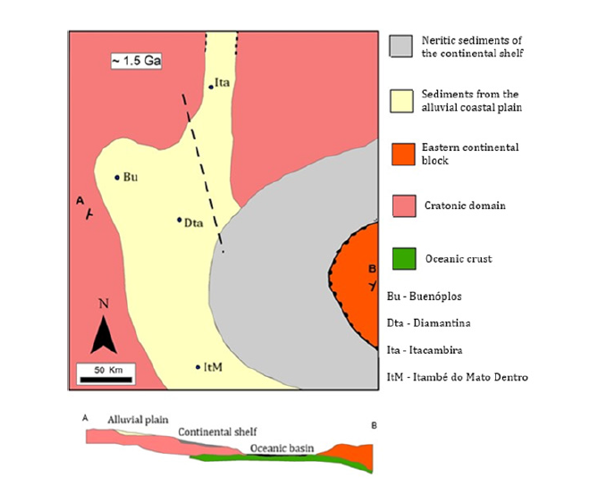
The outcropping rocks on the eastern edge of the SdEM have been the subject of controversy since the beginning of the 20th century, and the fact that the Iron Quadrangle’s BIFs are of Paleoproterozoic age has led many authors to discard Pflug’s [4] geosyncline model, on the assumption that the BIFs bordering the SdEM would be chronocorrelated to those of the Minas Supergroup [19,20,21]. However, geochronological dating of detrital zircons from quartzites intercalated in BIFs on the eastern edge of the SdEM revealed maximum sedimentation ages on the order of 1668Ma [22] and 1666Ma [23], which demonstrates the accuracy of Pflug’s model [4], in line with the detailed stratigraphic surveys of Partenoster [24] and Almeida-Abreu et al. [25], which showed interdigitations between rocks of the Sopa Brumadinho Formation and the Itapanhoacanga Formation. Rolim et al. [23] proposed alterations to the stratigraphy of the Serro Group by replacing the original designation with two other groups and introducing other formations. However, it is clear from the sections and maps presented that the authors did not consider the geological maps covering the entire southern and southeastern part of the SdEM (synthesized in Pflug & Renger [6,7,23,25,26], did not respect the precepts of stratigraphic nomenclature codes, as they aggregated lithologies from formations already established in the literature, especially the São João da Chapada and Sopa Brumadinho formations, and integrated them into new lithostratigraphic units. Furthermore, successions that maintain physical integrity and the same lithological compositions have been deliberately segmented into distinct units (groups and formations), and therefore the new stratigraphic propositions presented in your article do not seem reasonable, and we therefore do not use the proposed terms and stratigraphic organization. The Alvorada de Minas Ultramafic Suite is composed mainly of chlorite-actinolite/tremolite schists (occasionally containing talc, magnesite, chromitites, and carbonate), and steatites (soapstone). Serpentinite remnants are common, while preserved protoliths of peridotite and pyroxenite may occasionally appear.
Renger [27] recognized, through detailed petrographic studies, the original rocks of the suite, i.e., peridotites and pyroxenites, which underwent serpentinization during the intrusions and were subjected to regional metamorphism with chloritization and amphibolitization of the rocks and, subsequently, talcification and post-tectonic carbonatization through metasomatism with the addition of CO2. In the “Paca Mine” (Southeast of Alvorada de Minas) and Morro do Cruzeiro (Serro), the contact of the ultramafic rocks is notably discordant with the S0≈Sn of the enclosing quartzites, and near the village of Córregos bodies of ultramafic rocks are found embedded in the crystalline basement in notable discordance with the gneissic foliation of the substrate. Therefore, they represent synsedimentary intrusions, i.e., serpentinitic diapirism due to mantle hydration in the distal domain of continental crust thinned by the extensional process of the basin. Serpentinitic domes with the same tectonic environment and petrographic characteristics are observed off the coast of Galicia, off the southwest coast of Australia, on Zabargad Island (Red Sea), and in the Alpine System associated with the opening of the Ligurian Tethys (discussion and details about the intrusion of these ultramafic bodies with their respective bibliographic references can be found in Almeida-Abreu [7]). The ages obtained from different lithotypes (chromitites, talc chlorite schists, and steatite) of the Alvorada de Minas Ultramafic Suite revealed discrepant ages, that is, ages ranging from 2.05 to 2.2 million years [13], a variation of more than 150 million years.
The dated zircons, in addition to their very small dimensions, are embedded in rocks that have been subjected, as mentioned above, to different processes of hydration, metamorphism, and metasomatism, conditions that can distort the initial U and Pb ratios of the minerals (e.g., [16]). This age distortion is revealed by Hagedorn’s own studies [13], given that he obtained ages of 1651 to 2182Ma for amphibolite from Rio Mata Cavalo Suite and age of 1679Ma for mafic rock (quartz-chlorite-schist with magnetite) outcropping near Morro do Pilar, that is, rocks that supposedly have the same origin and the same age range showed very different crystallization ages. It is therefore suggested that, preceding the crustal break-up, large and extensive serpentinitic domes formed by the hydration of the underlying mantle ascended through the faults of the thinned crust, and can therefore be considered as the “proto-oceanic crust” of the Espinhaço Basin [7]. Several authors have considered the rocks of the Alvorada de Minas Ultramafic Suite as an Archean greenstone belt (e.g., [20]), however, the lithological associations, petrography, and igneous structures of this suite do not show characteristics of Archean greenstone belts.
The other units of the Serro Group, the Itapanhoacanga, Serra do Sapo, and Jacém formations, represent, respectively, remnants of the sedimentary facies of the coastal-intertidal zone, neritic zone, and continental slope. The first interdigitates with coastal aeolian and fluvial facies of the Sopa Bruamdinho Formation and accumulates deposits of banded iron formations up to several tens’ meters thick [25]. The second presents thick successions of BIFs with many tens to more than a hundred meters of thickness intercalated with phyllites and quartzites, and the last exhibits a thick succession of quartzites - occasionally with metric packages of layers in regular fining-upward alternations, characterizing turbitite deposits [7]. Furthermore, in the Jacém Formation, intercalations of phyllites and decametric successions containing ferruginous quartzites with decimetric levels of Banded Iron Formations (BIFs) are common. The units of the Serro Group, therefore, represent a typical section of passive continental margin established approximately 1.7Ga ago, according to U-Pb geochronological dating of zircons from rhyolites intercalated within these units [12,13]. In turn, the thick BIF deposits that extend from Serro to the Santa Maria de Itabira region, covering more than 120km, irrefutably demonstrate the presence of intense volcanic exhalations in mid-ocean ridge environments and anoxic waters that allowed Fe2+ to migrate to the continental shelf environments where oxic waters enabled the precipitation of banded iron formation deposits, as in other Proterozoic marine basins [28-30].
The Guinda Group (GGr)
The GGr, from base to top, comprises the São João da Chapada, Sopa Brumadinho, and Galho do Miguel formations and occupies most of the surface of the SdEM, including the Serra do Cabral (Figure 2 & Table 1). It is fundamentally composed of siliciclastic sediments, with smaller intercalations (in places with thicknesses greater than 10 meters) of igneous rocks, mainly of a basic nature, and also by intercalations of phyllites, conglomerates, and breccias. The widespread predominance of quartz-arenites, the absence of clasts in the conglomerates of rocks rich in labile minerals, and, above all, the extensive presence of hematitic phyllites, denote humid climate conditions with high weathering efficiency during the deposition of the GGr units [31], a climatic and weathering pattern that, in fact, persisted during the sedimentation of all successions of the Espinhaço System [7]. The hematitic phyllites that occur in the two lower formations as sills (lava flows or as thin dikes) represent paleo-laterites/bauxites resulting from weathering imposed on basic igneous rocks [32], which are sometimes still preserved as greenschists in the lower part of the hematitic phyllite sections.
Although in studies published up to the early 1980s the formations of the GGr were reported as being from marine environments, the characterization of the sedimentary facies demonstrated their fluvial and aeolian nature [7,19,21], when they were considered as successions that filled the Espinhaço Rift. However, considering the tabular nature of the GGr formations’ successions and their quasiregularity throughout the SdE (except for the presence of alluvial fans in specific areas of the Sopa Brumadinho Formation), Almeida- Abreu & Renger [17] characterized the sedimentary successions of this group as occupying a wide and extensive coastal plain located in the western vicinity of the Espinhaço marine basin, confirmed even by the interdigitation between fluvial and aeolian facies of the Sopa Brumadinho Formation with iron formations of the Itapanhoacanga Formation on the southeastern edge of the SdEM [24,25].
Furthermore, the successions of the GGr show relatively small thicknesses, therefore not suitable with a rift environment. The sedimentary flow from west to east (except for aeolian facies, which may be multidirectional) indicates provenance from the São Francisco Craton and granitic source rocks, as revealed by the heavy minerals in the arenites of the GGr formations [33], and therefore, the sediments were transported to the adjacent marine basin. Quartz-arenites are widely dominant in the coastal plain, which denotes both the widespread weathering of granitic source rocks under humid climate conditions [34,35] and a significant deficit of pelites, given that granites and granitoids do not account for more than 35% quartz in their original mineralogical composition. Apart from local accumulations of pelites in the Sopa Brumadinho Formation, resulting from synsedimentary tectonics that promoted the establishment of local base levels, the depositional environments of the GGr units and the unquestionable absence of vegetation cover favored the progressive and irremediable expulsion of pelites from the coastal plain to the adjacent marine basin located to the east. This situation prohibits any reference to the Espinhaço Basin as a sag basin, especially in the terms proposed by Martins-Neto [21], who considered the eastern limit of the basin to coincide with the eastern orographic limit of the SdEM itself, which obviously raises two questions: (1) where are or where have the pelites of the system been transported? (2) Why is there no sedimentary flow towards the interior of the basin, i.e., westward, on the eastern edge of the basin? Well, the unidirectional flow from the coastal plain ends in the unloading of sediments into the adjacent marine basin, also because the formations of the Serro Group are rich in pelitic successions.
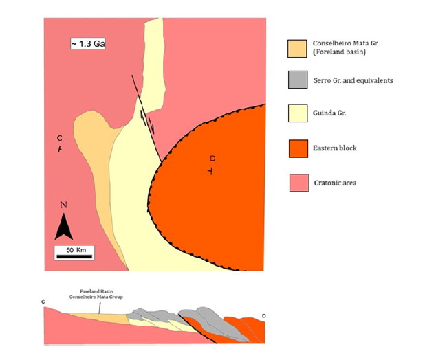
Important considerations regarding the GGr include the extensive presence of diamonds in the conglomerates of the Sopa Brumadinho Formation, which contain well-rounded clasts and paleocurrents indicating sedimentary transport eastward. This suggests a source area for both clasts and diamonds, located several tens of kilometers west of its rudite deposits. However, the intrusive diamond-bearing quartzitic breccias located at the top of this formation (maar-type breccias [31]) demonstrate a second kimberlitic event in the context of the depositional history of the Sopa Brumadinho Formation. It is noteworthy that, within the SdE region, diamonds are not found in any older or younger rocks relative to the ruditic rocks of this formation. Since the depositional age of the Sopa Brumadinho Formation is between 1.71 [12,36] and 1.68 [37], it supports the Serra do Espinhaço diamond province as the oldest in the planet’s history. On the other hand, since the Espinhaço basin marks the fragmentation of the Columbia/Nuna Supercontinent in the São Francisco Craton domain, it fits with what was proposed by Gernon et al. [38], that is, that kimberlitic magmatism was associated with the rifting process about 30 million years after continental breakup. No less important is the fact that the succession that makes up the coastal plain is deposited on the substrate of the São Francisco Craton on its southeastern edge and, even without exceeding two thousand meters in thickness, shows pervasive deformation and metamorphism of T≈450 °C and P≈4-5Kb [39], which indicates the superposition of thrust sheets originating from the east (according to the kinematic indicators imprinted on the rocks of the Espinhaço Supergroup) during the tectonic inversion of the basin (Figure 4).
Figure 4:Schematic representation of the Espinhaço orogen at approximately 1.3Ga, showing the formation of its foreland basin and the segmentation of the orogenic belt. Section C-D schematically represents the orogenic edifice over the ancient coastal alluvial plain that caused deformation and metamorphism in the GGr units and crustal flexure that formed the foreland basin.
The Conselheiro Mata Group (CMGr)
The five formations of this group, from base to top - Santa Rita, Córrego dos Borges, Córrego Bandeira, Córrego Pereira, and Rio Pardo Grande - outcrop exclusively in a narrow strip bordering the SdEM for approximately 180 km in a north-south direction (Figure 2 & Table 1), including the Serra do Cabral and its extensions (the Serra do Bicudo, and the Serra do Água Fria). These formations maintain remarkable lithological and facies regularity, alternating between predominantly pelitic and arenaceous successions, which imposes morphological characteristics of continuous, lowered bands flanked by bands of protruding relief. The pelitic units were invariably deposited in shallow marine environments, including vast tidal flat areas (Figure 8 & 9), while the sandstone formations (Córrego dos Borges and Córrego Pereira) exhibit high maturity (quartz-arenites) and comprise facies of coastal environments, including aeolian dunes and fluvial channel facies. This maturity reveals humid climate conditions during the deposition of the units from this group, further highlighted by the local presence of hematitic phyllites, i.e., paleo-laterites/-bauxites. The frequent presence of sandstones with feldspar contents on the order of 1% to 4% and locally reaching 10% of the rock volume [40], does not reflect arid climatic conditions but rather its geotectonic environment. Dupont [41] recorded the interdigitation between the formations of the CMGr within the western edge of the SdEM and Serra do Cabral (Figure 5), comprising alternations of marine transgressions (pelitic units) followed by the progradation of arenaceous units, the same situation observed in the more eastern and central domains of the basin that accommodated the units of this group. In turn, the paleocurrents obtained in the eastern domain of the trough show a clear pattern of coastal domains, including sedimentary flow from east to west [42], revealing, therefore, that the narrow range of occurrence of the CMGr encompasses the entire sedimentary trough that accommodated its sedimentary units. Furthermore, quartzitic breccias appear intercalated in fine sandstones and pelites of the Santa Rita Formation (Figure 6) in the eastern boundary of the sedimentary basin, indicating that the pebbles and blocks of milky quartz and quartzites (metamorphic rocks) bear witness to the erosional reworking of an orogenic relief of the east.
Figure 5:Stratigraphic successions highlighting the inherent dynamics of foreland basins, i.e., oscillations of subsidence (transgressions) versus progradation reflecting, above all, tectonic pulses of the orogen (Above: Conselheiro Mata Group, modified from Dupont [41]. Below: modified from Kuhlemann & Kempf [44].
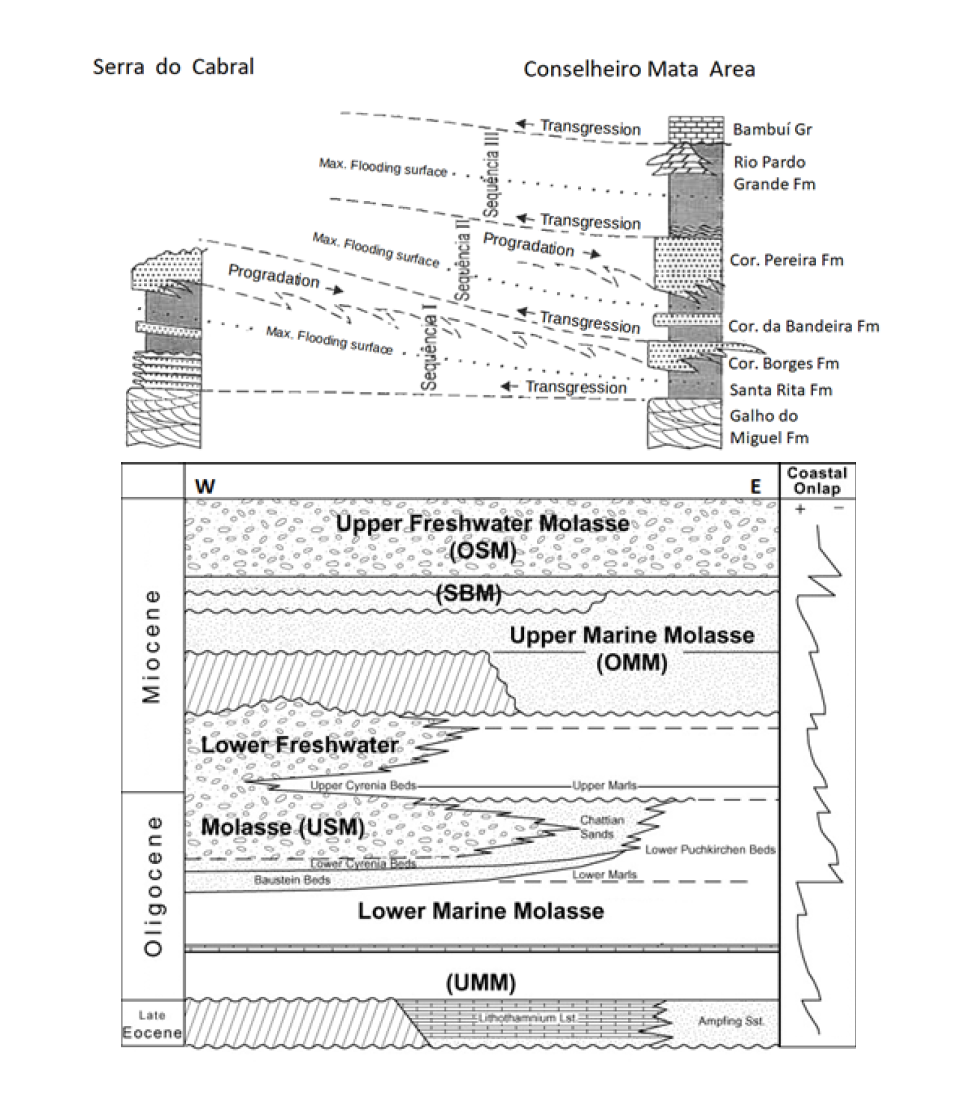
Figure 6:Quartzitic breccias of the Santa Rita Formation outcropping on the eastern boundary of the Conselheiro Mata Basin. Pebbles and blocks of milky quartz and quartzites bear witness to the erosional reworking of the orogenic relief of the east (UTM 620498 7974925).
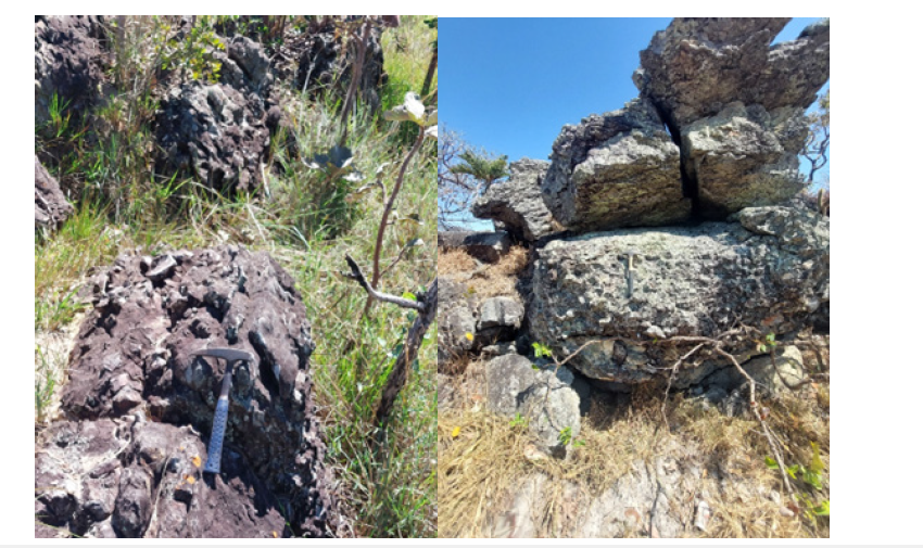
Figure 7:Córrego dos Borges Formation in the eastern domain of the Conselheiro Mata Basin. Left: intraformational breccias indicating reactivation of the relief; Right: exposure of aeolian beach dunes outcropping next to the intraformational breccias (UTM 619533 7974032).
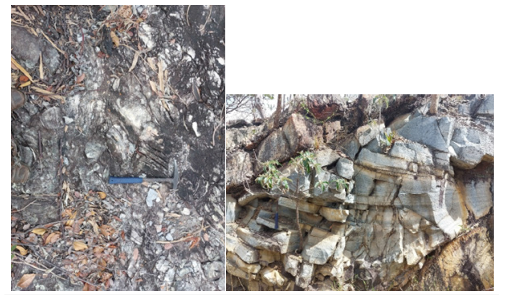
Figure 8:The central part of the Conselheiro Mata basin exhibiting beach depositional systems arranged side-by-side with tidal flat deposits. Left: Conglomeratic breccia in beach systems of the Córrego dos Borges Formation. Right: Mud cracks of the Córrego Bandeira Formation (UTM 609510 7969789).
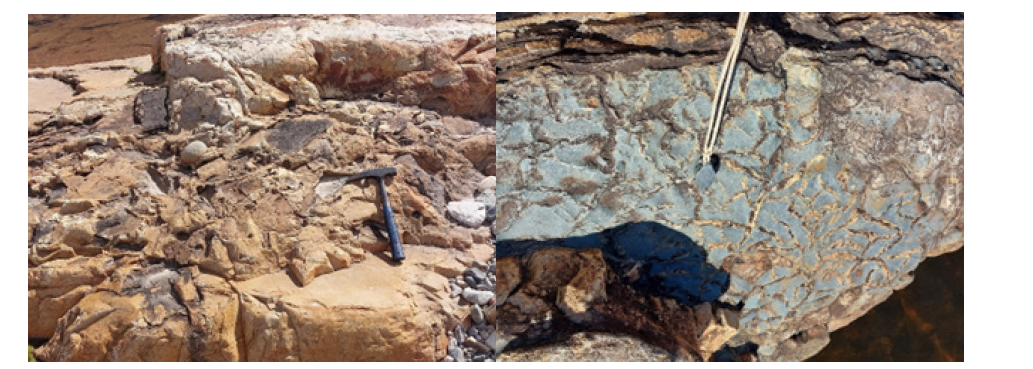
Figure 9:Tidal flat systems were the dominant environment in the lithostratigraphic units related to the subsidence phases of the Conselheiro Mata Foreland Basin. Left: Alternation of fine sandstones and pelites with flaser structures of the Córrego Bandeira Formation in the central area of the basin (UTM 609217/7969813). Right: Alternation of fine sandstones and pelites with sand dikes of the Rio Pardo Grande Formation in the western domain of the basin (607641/7977183).
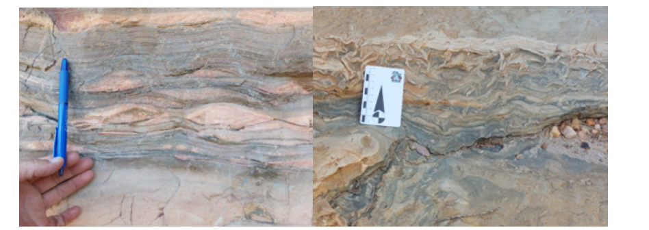
It is also observed that the Córrego dos Borges Formation in the eastern part of the Conselheiro Mata Basin exhibits intraformational breccias, indicating reactivation of the relief in the coastal domain, as evidenced by the aeolian dunes exposed in the area (Figure 7), demonstrating the progradation of sandy deposits over the coastal marine units, the same situation observed in the central domain of the Conselheiro Mata Basin (Figure 8). The geotectonic environment of the Conselheiro Mata basin is, therefore, materialized by its sedimentary facies, as well as by the alternation of subsidence (marine transgressions) versus progradation marked by the advance of sandy facies during periods of tectonic quiescence, silting up the adjacent marine domains. Given that this sedimentary trough is located in the western part of the Espinhaço Orogen and the maximum depositional age of its units (according to Santos et al. [43], detrital zircons from formations of the CMGr revealed ages on the order of 1,350Ma), it constitutes a foreland basin related to the propagation of thrust sheets that caused crustal thickening and subsequent flexure of the substrate at the front of the orogenic belt.
As previously reported, the succession that makes up the coastal plain does not exceed two thousand meters in thickness, however, rocks from the lower part of the GGr exhibit metamorphism of T≈450 °C and P≈4-5Kb [39], which indicates tectonic stacking on the order of 8-10km. Therefore, it is imperative to acknowledge the superposition of thrust sheets over the ancient coastal plain originating from the east (according to the kinematic indicators imprinted on the rocks of the Espinhaço Supergroup) during the tectonic inversion of the Espinhaço Basin, causing the adjacent subsidence of the crust and the formation of the foreland basin.
Different proposals regarding the origin of the basin and geotectonic environment of the CMGr have been presented by other authors. Dussin & Dussin [19] relate it to a post-rift phase with transgression throughout the basin during a period of tectonic stability, highlighting the absence of synsedimentary volcanism and also reporting crustal readjustment related to thermal subsidence. Martins-Neto [21] also relates thermal subsidence after thermal contraction of the lithosphere, which would have allowed the marine incursion that led to the deposition of the CMGr units. However, as already reported, the CMGr occurs exclusively in the western part of the SdEM (on rocks of the alluvial plain, i.e., of the GGr), accommodated in a narrow basin with sedimentary flow westward in its eastern part, therefore, it does not support the indication of marine transgression throughout the Espinhaço Basin, and, moreover, the rudites outcropping in the marginal and central domains of the basin preclude any relationship with transgressive basinal environments.
Santos et al. [43] indicate the CMGr as the uppermost sequence of the Proterozoic intracontinental Espinhaço basin, representing an example of transgressive-regressive cycles that developed in an intracratonic sag basin during the Stenian to early Tonian as part of the Upper Espinhaço Sequence of 1.8 to 0.92. However, the authors do not explain how a rift that began at 1.8Ga ceased its activity for 500 million years with the resumption of rifting at around 1.2Ga. Note that during the formation and evolution of the Espinhaço Rift proper, volcanism was pervasive, including the basalts of the Desembargador Otoni Group and the acidic and basic volcanic rocks that occur embedded or intercalated in rocks of the Serro and Guinda Groups, denoting the effects of both crustal extension and the continuous activity of subcrustal mantle plumes, which well characterizes the formation and evolution of sedimentary basins. In the CMGr successions, igneous rocks of any kind are virtually nonexistent, and therefore obvious questions arise: What would have motivated crustal extension and/or subsidence to enable the formation of a shallow marine basin after 500 million years of tectonic quiescence? Wouldn’t such a long time be sufficient to totally or partially erode the formations of the Guinda Group, which is not observed?
Would there then be two parallel and adjacent basins, given that detrital zircons from the BIFs of the Serro Group revealed maximum sedimentation ages on the order of 1666Ma [23], that is, the same age as the rocks of the Guinda Group? On the other hand, Santos et al. [43] highlighted a drastic change in the sediment supply due to changes in the paleocurrent pattern to the east and west caused by tidal influence and/or may reflect tectonic processes in the source area, events that are frequent in foreland basins [44], and references therein], since the implicit tectonism of these basins promotes the alteration of the regional relief and, consequently, changes in the directions of paleocurrents (Figure 5). Variations in the paleocurrent patterns of the CMGr units were also reported by [33,41,42].
Figure 10:Left: The two segments of the Serra do Espinhaço display terminal moraines from the Jequitaí Glaciation (~1Ga), thereby demonstrating that the segmentation occurred prior to the glaciation. Furthermore, the fact that these are alpine-type deposits indicates that the Serra do Espinhaço already existed as an orogenic entity before the glacial event. It should also be noted that the removal of glaciogenic rocks along sections of the Serra do Cabral margins and the western edge of the Serra do Espinhaço preceded the deposition of the Bambuí Group, revealing a clear unconformity between them. Right: The record of the pre-glacial Espinhaço Orogeny is evident on the northwestern margin of the SdEM, where tillites overlie lithologies of the Galho do Miguel, Santa Rita, Córrego dos Borges, Córrego Bandeira, and Córrego Pereira formations at the same topographic level. This indicates that the rocks of the Espinhaço Supergroup had already been tilted, folded, faulted, and deeply planed by an erosion surface when the tillites were deposited.
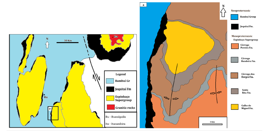
The successions that make up the foreland basin of the Espinhaço System were deformed during the tectonic evolution of the Espinhaço orogen, a phenomenon inherent to all orogenic belts. However, it shows a somewhat different deformation pattern from the other successions of the Espinhaço Supergroup, as well as in the degree of metamorphism, since the rocks of the CMGr show an incipient degree of metamorphism (anchimetamorphism), especially within the Serra do Cabral, while the other successions of the system show metamorphism of the lower to high greenschist facies. The orographic building resulting from the Espinhaço orogeny remained exposed for a long time, from the end of the deformation until the advent of the Jequitaí Glaciation at approximately 1.0Ga. The erosion imposed on the SdE preceding the glaciation is well documented in the northwestern part of the SdEM (Figure 10) and in the southern part of the northern segment of the mountain range, where glaciogenic rocks lie directly on the crystalline basement [7].
Note in Figure 10 that prior to the deposition of glaciogenic sediments, no less than 1200 meters of rocks from the CMGr were removed by erosion, also showing remarkable tectonic structuring of the orogeny prior to the glaciation. Furthermore, prior to the deposition of the pelitic-carbonate units of the Bambuí Group, that is, before the beginning of the Cryogenian period, parts of the fringe of glaciogenic rocks bordering the western edge of the SdEM were completely eroded - the same situation seen in the Serra do Cabral - which clearly demonstrates that both, the successions of the Bambuí Group do not represent cap carbonates of the Jequitaí Glaciation and that this glacial event represents a mountain glaciation of about 1.0Ga [45].
The Jequitaí glaciation
The first mentions of glacial rocks in the SdE region are attributed to Branner [46], while Moraes [47] designated the phyllites, mica schists, conglomeratic phyllites, quartzites, and limestones of the Serra do Catuni and Ribeirão Macaúbas as the Macaúbas Formation, which includes glaciogenic rocks. However, it was Isotta et al. [48] who discovered striated pavements on quartzites of the Espinhaço Supergroup in the Serra da Água Fria region (northwestern extension of the Serra do Cabral), thus confirming both the glacial origin of the diamictites outcropping in the region and their continental nature. A spectacular record of striated pavement is also seen in the Serra do Cabral (Figure 11).
Figure 11:After rising above the snowline during the late Mesoproterozoic, the Serra do Espinhaço orogenic edifice became a center of glacial dispersal -a process that eroded and transported rock fragments that then made up the mountain range. Left: Schematic map showing the tectonic structure of the Espinhaço orogen during the late Mesoproterozoic (modified from Almeida-Abreu et al. 2001). Right: Spectacular glaciogenic structure (striated pavement) on rocks of the Córrego dos Borges Formation, in the Serra do Cabral (UTM 583560/0155457).
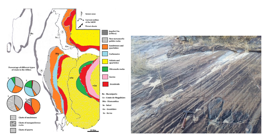
The diamictites that outcrop in the Serra do Cabral realm and bordering the Serra do Espinhaço were then considered to be from a glaciation over vast territories of Minas Gerais and Bahia, referred to by Karfunkel & Hoppe [49] as a continental glaciation. However, D’Agrella Filho et al. [45] carried out paleomagnetism studies on basic rocks from dykes of the eastern São Francisco Craton that revealed high paleolatitudes, i.e., 40° to 65° N between 1.0 and 1.1Ga, and therefore considered the deposition of the glaciogenic units to have occurred around 1.05Ga. This proposal aligns with the geotectonic evolution of the SdE and with regional stratigraphic relationships, that is, the tillites and associated rocks outcrop only on or bordering orogenic belts formed during the Mesoproterozoic, thus demonstrating a glacial phenomenon of the “Alpine type” (i.e., mountain glaciation) related to the epeirogenesis of the orogenic entities of the São Francisco Craton, which were uplifted to altitudes above the snowline. The absence of clasts of basic rocks from the Pedro Lessa Suite (~920 to 906 Ma [12,50]) in tillites of the Jequitaí Formation, despite the rocks of this suite occupying at least 2.5% of the surface of the Espinhaço Supergroup [51], confirms the Mesoproterozoic age of the glaciation, thus reporting it as the first post-Huronian glaciation. It should be noted that extensive dikes of the Pedro Lessa Suite are embedded in rocks of the Espinhaço Supergroup, sectioning tectonic structures generated by the Espinhaço Orogeny (folds, faults and shear zones, Figure. 2). The indelible record of the Espinhaço Orogeny as a pre-glacial event is explicit on the northwestern edge of the Espinhaço Supergroup (SdEM), where a fringe of glaciogenic rocks simultaneously covers lithologies of the Galho do Miguel, Santa Rita, Córrego dos Borges, Córrego Bandeira and Córrego Pereira formations over the same topographic datum (Figure 10), indicating that the rocks of the Espinhaço Supergroup were already tilted, folded, faulted, and deeply leveled by the erosion surface when the tillites were deposited. Furthermore, they rest on lithologies of the Sopa- Brumadinho Formation in the northeast of the SdEM, revealing a previous erosion of at least 2500 meters of the sedimentary pile of the Espinhaço Supergroup. Along the same lines, fringes of tillite are observed contouring the two segments of the Serra do Espinhaço (Figure 10), which reveals both the orogenesis and the segmentation of the mountain range prior to glaciation.
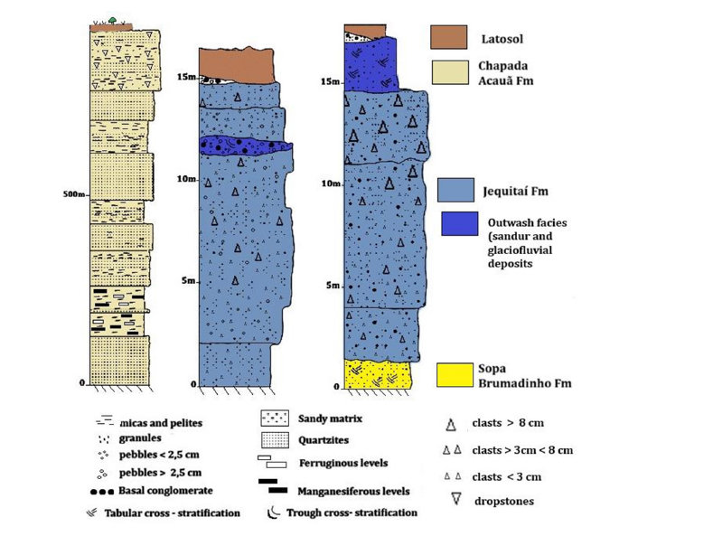
Based on the above, it is indisputable that at the end of the Mesoproterozoic SdE constituted a mountain range built by a pile of rocks no less than 8km thick, containing rocks of different natures (Figure 11), which are recorded as clasts in the tillites that now border the mountain range. Figure 12 & 13 show clasts of different types of metamorphic rocks with explicit deformation that were part of the orogenic edifice of the SdE at ~1Ga. In Figure 11, the pie graphs show the different types of clasts in the tillite fringes surrounding the SdE, a fact also confirmed by Faria [52]. This sectorized distribution of different types of clasts on the fringes surrounding the orogenic edifice denotes the existence of different rock layers (thrust sheets) composing the top of the mountain range during the glacial period, and this explicitly differentiated distribution of clasts over distinct areas of the mountain prohibits the origin of glaciers from distant areas, that is, from a continental glaciation, because if that were the case, a much more homogeneous clast composition would be expected throughout the region. Furthermore, the terminal glacial deposits of continental glaciers are very thick; for example, the glacial drift of the Great Lakes region related to the retreat of the Laurentide Ice Cap varies from 60m to 120m, exceeding 350m in some places [53], while the tillites of the Jequitaí Formation generally do not exceed 20-30 meters (Figure 14).
Figure 12:Tillites from the Couto de Magalhães quarries showing clasts of different natures embedded in a sandy matrix rich in feldspars and micas, including clastic biotite. The clasts, mostly angular, exhibit one or more tectonic and metamorphic structures related to the Espinhaço orogeny. Left: Tillite with clasts of quartzite, quartz, glimerite, carbonates, the largest of which is gneiss (UTM 661743/8000325). Right: Angular clast of dolomite exhibiting fractures of different orientations filled with calcite, denoting deformation and metamorphism of the rock before being deposited in the tillite (UTM 660753/8000595).
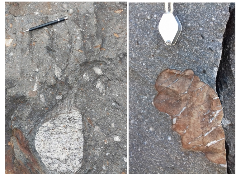
Figure 13:Left: Tillite from Couto Magalhães quarry exhibiting glimerite with two distinct foliations (unrelated to deformation of the host rock) (UTM 661743/8000325). Right: Tillite from the western edge of the Serra do Espinhaço (Curimataí area) highlighting a quartzite clast more than one meter in diameter, showing explicit deformation and metamorphism before being deposited in the tillite, according to the complex system of fractures filled by quartz veins (UTM 610625/8021009).
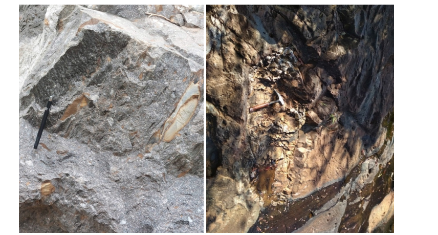
Figure 14:Left: stratigraphic section of the Mata Acauã Formation extending eastward from Couto Magalhães de Minas (UTM 663036-8001380) to the base of the plateau (665518-8003894). The section presents a succession of phyllites, quartzose phyllites, and micaceous quartzites with a notably high Chemical Index of Alteration (CIA), a degree of weathering maturity also evidenced by thick intercalated layers of quartz arenites, revealing sedimentation under warm and humid climatic conditions. In contrast, the upper portion of the section displays successions of pelites and quartzites with the frequent presence of dropstones, indicating the glaciogenic nature of the rocks. Right: Sections of tillites from the Jequitaí Formation. Note that the formation does not exceed 20 meters in thickness, including its glaciofluvial facies (outwash deposits). Note also that remnants of basal conglomerate appear above the tillites.
From the perspective of the Jequitaí Glaciation as a continental glaciation, its deposits in the SdE region would be terminal deposits, since, in this hypothetical case, the rocky protuberances would be nunataks, blocking the regular advance of glaciers that would accumulate their thick tillites between the elevations. Also, from the perspective of the existence of a regional base level, i.e., the Araçuaí marine basin to the east, the advance of continental glaciers to reach the base level would create deep incisions, i.e., fjord-type canyons, sectioning the elevations from the Espinhaço mountain range. Now, such deep, depressed structures would have a high potential for preservation, and no evidence of such incisions is known.
Many of the controversies surrounding the Jequitaí Glaciation stem from the pervasive occurrence of glaciogenic rocks in units of the Araçuaí Belt, particularly in the Nova Aurora and Chapada da Acauã Formations. The latter, with detrital zircon dating performed by Pedrosa-Soares et al. [54], despite the uncertainties reported by the authors, admitted a maximum sedimentation age of 950Ma. These authors report the Serra do Catuni Formation as belonging to the Araçuaí Belt succession as a proximal glaciogenic unit representing the extension of the glacial sedimentation from the cratonic region (Jequitaí Formation). In the proposal by Noce et al. [55], the Serra do Catuni Formation included all glaciogenic rocks in the SdE realm, which, besides disregarding the norms of stratigraphic nomenclature codes, made it difficult to differentiate units that are not chrono correlated.
The Jequitaí Formation, as defined by Isotta et al. [48], comprises glaciogenic rocks (mainly tillite) that border the rocks of the SdE as semi-continuous fringes, varying in thickness from a few to several meters (Figure 14) and prograding laterally for tens to hundreds of meters as terminal glacier deposits, sometimes forming restricted lakes as seen in variety deposits in some locations of the Serra do Cabral (e .g., west of Augusto de Lima and in the Felício dos Santos area), or as fluvioglacial systems [52] and sandur (glacial outwash plain) deposits in the area of the Couto Magalhães de Minas suspension bridge.
Similar successions were also recognized at the northern end of the SdEM, where tillite layers alternate with cross-bedded fluvial quartz-arenites typical of glaciofluvial outwash deposits [56]. Furthermore, it was found that the sediments of the glaciogenic rocks originate from the SdEM and the cross-stratifications showed paleocurrents with unidirectional flow to the southwest, that is, from the elevations of the northwestern termination of the SdEM towards the cratonic area. The presence of cherts - very limited in both volume and spatial distribution - does not represent marine deposits as proposed by Oliveira [56]. In fact, these are local silica precipitates deposited in a small lake formed at the glacier’s terminus following its retreat, given that the undeniable excess of dissolved silica in meteoric waters is attributable to the acidity of the Earth’s atmosphere in the context of the “faint young Sun” during the Precambrian [57-61]. Therefore, the rocks pertaining to the Jequitaí Formation are glaciogenic rocks of continental environment and do not include rocks from marine environments, i.e. rhythmites and pelitic successions with dropstones that outcrop in different domains of the Araçuaí Belt and in the adjacent areas of the SdE, especially in the Jequitinhonha Valley from the Água Verde area to the municipality of Olhos D’Água and from the area of the villages of São Gonçalo da Canjica and Tomé to the Planalto de Minas region. In this way, the continental glaciogenic units (tillites) that form fringes on the edges of the SdE anywhere are integrated, according to the precepts of the stratigraphic nomenclature codes, into the Jequitaí Formation, while the diamictites from other depositional environments comprise, in whole or in part, the Serra do Catuni, Nova Aurora, and Chapada da Acauã formations.
The stratigraphic section from the town of Couto Magalhães de Minas at an altitude of ~700 meters asl to Tomé at an altitude of ~900 meters asl (Figure 14) shows the following succession: ferruginous sandstones of the Sopa Brumadinho Formation covered by tillites of the Jequitaí Formation, approximately 16 meters thick including the lateral fluvioglacial facies (outwash deposits), which are covered by thick latosol that laterally to the north shows remnants of clast- or matrix-supported conglomerates, with a sandy, ferruginous matrix containing quartz granules, and a framework consisting exclusively of well-rounded and few sub-rounded milky quartz clasts (pebbles and blocks) denoting the character of a basal conglomerate. From this point eastward, the slope that ascends to the adjacent plateau over a horizontal extension of 5km exposes phyllites, quartzose phyllites, fine quartzites, with or without iron and manganese, in alternating levels of millimeter to decimeter thicknesses, and towards the top with a predominance of thick successions of quartzites with micaceous levels, and in the upper part of the succession the quartzose phyllites may contain isolated centimeter to decimeter clasts (dropstones). The section is many hundreds of meters thick and comprises the Mata Acauã Formation in the region.
In the area from São Gonçalo da Canjica to Tomé, altered pelites predominate beneath the surface of the plateau, sometimes with metric levels of quartzites, with frequent dropstones in the phyllites denoting the glaciogenic character of the rocks. Note that between the tillites of the Jequitaí Formation and the phyllites with dropstones, there is a thick succession containing phyllites with a remarkably high Chemical Index of Alteration (CIA), weathering maturity also revealed by the thick intercalated quartz-arenites. It is therefore clear that between the two glacial events, siliciclastic sedimentation predominated for an extended period under warm and humid climatic conditions, a time lapse that may have totaled more than 200 million years. In the Tomé section descending towards the thalweg of the Jequitinhonha River, the phyllite deposits with dropstones lie directly on the sandstones of the Duas Barras Formation, which also exhibit quartz-arenites, rare levels of phyllites and local layers of conglomerates containing pebbles and quartz granules (rare quartzites), thus highlighting significant climatic variation during the deposition of these formations.
Castro et al. [62], among other authors, confirmed the Early Cryogenian age of the glaciomarine deposits of the Chapada Acauã Formation (between 720-670Ma), correlating it with the Sturtian global glaciation. Along the same lines, Pacheco et al. [63] dating of 182 detrital zircon grains from the Lower Chapada Acauã Formation in southern Bahia, with the youngest zircons being 753±12Ma old. Based on the above, the existence of at least two major glacial events within the São Francisco Craton seems undeniable, namely the Jequitaí Glaciation, at ~1.0Ga, an alpine-type glaciation imposed on the mountainous areas of the late Mesoproterozoic, and the Sturtian Glaciation at ~700Ma, a global glaciation related to an unusual episode called Snowball Earth.
A Brief Comparison of Competing Geodynamic Models
In concluding this review article on the geodynamic evolution of the Serra do Espinhaço, stratigraphic, sedimentological, tectonic, petrological, and geochronological data are integrated to visualize basial and orogenic geological processes, with the aim of presenting a brief synthesis highlighting Comparison of Competing Geodynamic Models.
a) Since the advent of “plume tectonics” [64,65] the formation of rifts/basins has been irrevocably associated with mantle plumes, except for a few intracratonic basins and basins inherent to tectonic inversions. The Espinhaço rift/basin was no exception and began with the pre-rift phase with potent basaltic volcanism in the Planalto de Minas-São Gonçalo do Rio Preto region (Desembargador Otoni Group, Figure 2 & Table 1). Now, apart from the established crystallization age of around 1.75Ga [12,13], the rocks show an unquestionable signature of continental basalts accumulated in intermittent volcanic episodes according to the intercalations of peripheral sedimentary deposits that built the extensive skirt intrinsic to continental volcanic edifices. It does not seem at all reasonable to consider this pre-rift volcanism as part of the crustal extension that formed the Araçuaí Belt basin at 900-800Ma [14] as it contradicts consistent geochronological data and, moreover, there is an explicit angular unconformity between the basaltic rocks and associated deposits with the phyllites with dropstones of the Chapada da Acauã Formation that overlay them [11]. It is observed that the volcanoes of the Desembagacor Otoni Group align with the axis of the Northern Espinhaço Range, indicating the primitive positioning of the Espinhaço Basin before the segmentation caused by dextral strike-slip faults during the previously reported tectonic inversion. These volcanoes are aligned to the south with the various synsedimentary volcanic bodies (rhyolites and greenschists) intercalated in the continental shelf successions of the Serro Group. The sub-crustal presence of an extensive mantle plume established an active rift lasting approximately 30 million years and culminated in continental breakup around 1720Ma, as evidenced by the serpentinite diapirs (proto-oceanic crust) of the Alvorada de Minas Ultramafic Suite, which occupy areas along the eastern margin of the SdEM. The rocks of this suite do not exhibit the petrography or lithological associations that would allow for correlation with Archean Greenstone belts. Furthermore, serpentinite bodies are observed hosted within rocks of the Espinhaço Supergroup, a fact that reinforces the petrographic studies of Renger [27], who noted extensive serpentinization of mantle rocks prior to any metamorphic or metasomatic process. Geochronological dating of rocks from this suite reveals no coherence with regional geological events; specifically, the ages of 2.0-2.2Ga - aside from an uncertainty of 200 million years - do not correspond to any regional tectonic event capable of driving the formation or intrusion of ultramafic rocks during that period. Furthermore, geochronological results spanning a range of over 200 million years demonstrate intrinsic inconsistency, likely due to sample quality or to metamorphic and/ or metasomatic processes that altered the minerals’ original isotopic ratios. Notably, two rock samples attributed to the same suite yielded discordant ages - ranging from 1651 to 2182Ma and at 1679Ma [13] - which reinforces the inconsistency of the geochronological data obtained to date for the rocks of the Alvorada de Minas Ultramafic Suite. Evidence pointing to continental breakup prior to 1700Ma includes the kimberlitic magmatism that introduced diamonds into the rocks of the Sopa Brumadinho Formation. Such magmatism is characteristic of tectonic reactivation in adjacent continental areas following continental fragmentation [38].
b) The rocks and successions of the Serro Group have been the subject of controversy regarding their origin and ages since the beginning of the 20th century (see discussions in [7,8,25]). This is because thick and extensive Banded Iron Formations (BIFs) would, in theory, be correlate to similar lithologies of the Minas Supergroup of the Quadrilátero Ferrífero and, moreover, because the successions of the Serro Group outcrop on the margin of the SdEM itself. Note that the Paleo-/Meso-proterozoic units of the Espinhaço Supergroup that constitute the SdEM proper are predominantly quartzitic rocks of continental environment (Pflug’s miogeosynclinal facies [4] and rift successions since Almeida-Abreu [7]), later recognized as successions of a large and extensive alluvial plain located in the western vicinity of the marine basin represented by the Serro Group [10,17]. Assuming that the GGr successions, together with the CMGr units, represent a sag-basin composed exclusively by the rocks of the Espinhaço Supergroup that build the SdEM, some authors maintain the GGr units as deposited in a rift environment (e.g., [19,21,43]). Even though it was demonstrated, a posteriori, by the geochronology of detrital zircons from quartzitic rocks intercalated in BIFs [22,23] that the successions of the Serro Group are chronocorrelated to the units of the GGr - consistent, therefore, with the stratigraphic records presented by [4,24,25] - the sag-basin proposal was already scientifically unsustainable due to the imbalance of the GGr sediments, i.e., the significant deficit of pelites in its quartzitic successions, and because the paleocurrents, anywhere, show unidirectional flow eastward, i.e., towards the adjacent marine basin. Therefore, the Guinda and Serro groups bring together successions of larger compartments of a basin and according to the marine shelf facies of the Serro Group (Figure 3 & Table 1), including the thick banded iron formations deposited after the oxidation of Fe2+ from the volcanism of the mid-ocean ridge, according to their nature of chemical precipitates over a longitudinal extent of hundreds of kilometers (Figure 2), thus composing typical deposits of Proterozoic continental margins [66]. The crustal extension followed by breakup and subsequent thermal subsidence of the crust created the spaces of the wide and extensive coastal alluvial plain in the western vicinity of the marine basin where the successions of the GGr were accommodated.
c) In the context of the basinal evolution of the alluvial plain that accommodated the GGr, the Sopa Brumadinho Formation, unlike the formations that underlie and overlie it - which show sedimentary deposits typical of a stable platform in a tectonic quiescence environment - exhibits some characteristics of rifttype environments, given the presence, in specific areas, of many conglomerate bodies. Although isolated bodies of conglomerates (generally monomictic to quartz pebbles) of decimetric to metric thicknesses and quartzites with pebbles are common in the successions of the Sopa Brumadinho Formation within its exposures in the SdEM, the thick and extensive bodies (up to 6 x 80 meters) of conglomerates - generally coalescent bodies - compose alluvial fans of the diamondiferous districts of Sopa-Guinda, Datas and Presidente Kubitschek. These alluvial fans show eastward progradation systems and, in the presence of the predominant rounded sandstone/quartzite clasts, indicate both reworking of the basin’s own deposits from synsedimentary tectonic movement and source areas of diamonds in these tectonically unstable domains located tens of kilometers to the west. There is no record of the presence of diamonds, within the SdEM, in rocks from units prior to or subsequent to the Sopa Brumadinho Formation, which establishes a cause-and-effect relationship: the continuity of crustal extension reactivated the 1st order structural lineaments of the cratonic area, causing tectonic instability in the coastal plain in conjunction with kimberlitic magmatism that mineralized the conglomerates with diamonds.
d) The Espinhaço passive margin, established before 1.7Ga, projects the start of the tectonic inversion to before 1.5Ga considering modern parameters of oceanic crust stability after its formation [67], it being possible that the collapse occurred in a shorter time under the warmer thermal parameters of the Precambrian mantle [68,69]. There are no known records (stratigraphic or geochronological) of the start of the tectonic inversion, which is marked by the advance of a crustal block originating from the east towards the southeastern edge of the São Francisco Craton (Figure. 3), but around 1.3Ga, according to detrital zircon ages of CMGr units [43], an orogenic edifice was already established throughout the central and eastern area of the current SdEM. As previously reported, the CMGr units were accommodated in a narrow basin located in the western part of the orogenic belt (Figures 2 & 4, Table 1), which combines sedimentary facies (Figures 6-9) and basinal dynamics (Figure 5) typical of a foreland basin. The record of this orogenic structure that caused a crustal flexure in the outer part of the orogenic belt is also evidenced by the metamorphism of the basal units of the GGr in the central part of the SdEM, which reveal T of ~450 °C and P of ~4-5kb [39] due to a stacking of thrust sheets on the order of 8-10km. Furthermore, rocks that composed the orogenic edifice appear as clasts in the tillites of the Jequitaí Glaciation that border the SdEM (Figures 11- 13).
e) The alternative model that the CMGr units were deposited in a rift [43] finds no conceptual support or sedimentological record. Indeed, hundreds of igneous rock bodies with ages between 1,750Ma and 1,680Ma [12,13,36,37] are found within the Desembargador Otoni, Serro and Guinda groups, revealing volcanism from the pre-rift, rift and basinal phases, certainly fed by mantle plumes inherent to the formation and development of sedimentary basins. The time lapse from the early volcanism of the Desembargador Otoni Group to the deposition of the CMGr units exceeds 500 million years, which makes any relationship of basinal continuity between the Espinhaço Basin proper and the “Conselheiro Mata Basin” unfeasible, although the latter integrates the Espinhaço System but as an entity generated by its own tectonic process of orogenic evolution. As already mentioned, the sedimentary facies and basinal dynamics shown by the CMGr lithologies do not match continental rift successions, which invariably show: (a) edges of the sedimentary trough controlled by faults with the formation of grabens and hemi-grabens; (b) rapid facies variations in the transverse and longitudinal directions; (c) significant thickening of deposits on the margins of synsedimentary faults with a strong contribution of rudites; (d) edges of the trough dominated by continental deposits prograding towards the center of the rift; (e) marine and/or lacustrine environments in the central area of the rift containing turbidity current deposits; (f) when the central area of the rift is dominated by fluvial systems, the sedimentary flow has a longitudinal direction. As described and represented previously, the five formations of the CMGr do not show any of the characteristics inherent to rifts, showing, in fact, somewhat discreet episodes of subsidence (Santa Rita, Córrego Bandeira and Rio Pardo Grande formations), followed by silting due to the advance of sandy facies over the marine systems, cycles that mark tectonic pulses of the orogenic belt, which is typical of the evolution of foreland basins (Figure 5).
f) The wandering of the São Francisco Craton through high latitudes around 1.0Ga [45] imposed glacial environments on its mountainous areas, therefore alpine-type glaciation as evidenced by the tillite deposits surrounding as fringes the orographic entities. Recent geochronological dating has shown that detrital zircons from the Jequitaí Formation are older than 1Ga [56], including samples from two different areas of the western edge of the SdEM (Ginaldo A C Campanha, oral communication, article in preparation). This glacial event is of scientific relevance as it is the first post- Huronian glaciation. Different authors argue for the occurrence of a single Precambrian glaciation within the São Francisco Craton, thus associating the deposits of the Jequitaí Formation with the glacio-marine sediments of lithostratigraphic units of the Araçuaí Belt related to the Sturtian glaciation [54-56]. This proposition is hindered not only by the distinct ages of detrital zircons, but also by the fact that the lithologies of the Jequitaí Formation contain only deposits of continental origin, including periglacial sediments, that is, the fluvioglacial deposits that mark the outermost limit of mountain glaciations (Figure 14). Furthermore, the basaltic rocks of the Pedro Lessa Suite (defined as the Bahia-Gangila LIP with ages between 920-900Ma [50]), despite occupying more than 2.5% of the SdEM surface, do not appear as clasts in the tillites of the Jequitaí Formation, thus suggesting that the Jequitaí glaciation occurred before 920Ma. The rocks of the Pedro Lessa Suite also represent an important regional stratigraphic landmark, given that they do not exhibit deformation or metamorphism and are embedded in rocks of the Espinhaço Supergroup, cutting across all its tectonic structures, including folds, faults, and shear zones, which indicates, therefore, that the Espinhaço Orogeny occurred in the Mesoproterozoic.
g) In the crustal shortening process of the Mesoproterozoic Espinhaço Orogeny, deformation was attenuated by the reactivation of ancient crustal structures with a northwestward trend, resulting in a dextral movement that displaced the southern segment of the orogenic belt relative to the northern segment (Figures 1 & 3). The geometric arrangement of the northern segment relative to the passive margin of the southern part configures it as an aulacogen, represented by a relatively narrow and linear basin with its characteristic sedimentary facies. At the end of the Neoproterozoic, the Pan-African/Brasilian orogeny caused regional crustal heating that affected the entire Serra do Espinhaço and the Quadrilátero Ferrífero region due to oceanic plate subduction related to the tectonic inversion of the Western Congolese Belt under the lithosphere of its counterpart, the Araçuaí Fold Belt [7,70]. The Brasiliano cycle in the region was also responsible for imposing crenulation cleavage in rocks of the Espinhaço Supergroup in some locations (e.g., [11]), as well as for the reactivation of faults. In the Serra do Cipó area (southwest edge of the SdEM), the reactivation of an extensive high-angle (45-70°) north-south trending fault thrusting rocks of the Espinhaço Supergroup over successions of the Bambuí Group [71], causing intense deformation in the rocks of this group. This scenario has motivated much controversy regarding the age of the orogeny that built the Serra do Espinhaço, however, the tectonic reactivation of orogenic belts resulting from subsequent tectonic cycles, even if hundreds of kilometers away from the new collision/subduction focus, especially of their larger structures, i.e., faults and shearzones, is known and described in different continents and from different geological eras ([72-76], see discussion in Almeida-Abreu et al. [70]).
h) In the specific case of the reactivation of Espinhaço Orogen structures with the westward movement of blocks deforming adjacent Neoproterozoic rocks, this occurred mainly in the thicker and more mobile parts of the orogenic belt [7], unlike what occurred in the less deformed and therefore less unstable domains of the orogen, as can be seen in Figure 10. This figure didactically represents both that the Espinhaço orogeny preceded the Jequitaí Glaciation, as well as the record of erosion of part of the glaciogenic rocks before the deposition of the Bambuí Group successions. Furthermore, Figure 10a shows the record of tillites covering lithologies of the Galho do Miguel, Santa Rita, Córrego dos Borges, Córrego Bandeira and Córrego Pereira formations at the same topographic level. This indicates that the rocks of the Espinhaço Supergroup had already been tilted, folded, faulted and deeply flattened by an erosion surface when the tillites were deposited.
Acknowledgement
We express our gratitude to the hundreds of students from the Eschwege Geology Center (UFMG), the undergraduate course in Geological Engineering (UFVJM), and the Postgraduate Program in Geology (ICT-UFVJM) for their participation in fieldwork related to geological mapping programs courses and undergraduate theses, as well as in fieldwork for the preparation of master’s dissertations. Many colleagues from ICT-UFMG and the Geological Engineering course at UFVJM also participated in this fieldwork, and we also extend our thanks to them.
Declaration of Competing Interest
The authors declare that they have no known competing financial interests or personal relationships that could have appeared to influence the work reported in this paper.
References
- Eschwege W (1822) Geognostic depiction of Brazil and the probable source rock of diamonds. (Landes-Industrie-Comptoir) Weimar, p. 44.
- Eschwege W (1833) Pluto Brasiliensis. Berlin-Reimer. In: Murta DF (Ed.), Itatiaia/Edusp, Belo Horizonte/São Paulo, Brazil, 2: 622.
- Derby OA (1906) The serra do Espinhaço, Brazil. J Geol 14(5): 374-401.
- Pflug R (1965) The geology of the southern part of the Serra do Espinhaço and adjacent areas, Minas Gerais. DNPM, Division of Geology and Mineralogy, Rio de Janeiro, Brazil, Bulletin 226: 51.
- Pflug R (1968) Observations on the stratigraphy of the Minas Series in the Diamantina region. Dept Nac Research Mineral (DNPM)/Dept Geol Miner, Preliminary Study Notes, Rio de Janeiro, Brazil, p. 142.
- Pflug R, Renger FE (1973) Stratigraphy and geological evolution of the southeastern margin of the São Francisco Craton. Proceedings of the 27th Brazilian Geological Congress, Aracaju, Sergipe, Brazil 2: 5-19.
- Almeida Abreu PA (1993) The geodynamic evolution of the Southern Serra do Espinhaço, Minas Gerais, Brazil. PhD Thesis, University of Freiburg, Freiburg, Germany, p. 150.
- Renger FE (1979) Evolution of geological concepts regarding the Serra do Espinhaç Proceedings of the 1st Symposium on the Geology of Minas Gerais, Diamantina, MG, Brazil, Bulletin 1 of the Brazilian Geological Society (Minas Gerais Section), pp. 9-27.
- Renger FR, Knauer LG (1995) Espinhaço-quo vadis? (where is it? -where are you going?) - The evolution of knowledge about the Southern Espinhaço Mountain Range in Minas Gerais between 1979 and 1995. Geonomos 3(1): 31-39.
- Almeida-Abreu PA, Renger FE (2007) Stratigraphy and facies of the southern Serra do Espinhaço, Minas Gerais, Brazil. Zeitsch Deutschen Gesellsch Geowissensch 158(1): 9-29.
- Chula AMD, Knauer LG, Almeida-Abreu PA (1995) Stratigraphy of the Espinhaço Supergroup in the Planalto de Minas region, Diamantina, Minas Gerais. Geonomos 3(1): 69- 81.
- Machado N, Schrank A, Abreu FR, Knauer LG, Almeida-Abreu PA (1989) Preliminary results of U/Pb geochronology in Serra do Espinhaço meridional. Proceedings 5th Symp Geol Minas Gerais, Belo Horizonte/MG/Brazil, pp. 171-174.
- Hagedorn MG (2004) Geotectonic setting of the Serra do Espinhaço and adjacent domains to the east (Minas Gerais), with emphasis on geochemical and geochronological aspects. PhD Thesis, Institute of Geosciences and Exact Sciences, São Paulo State University, Rio Claro, SP, Brazil, p. 222.
- Babinski M, Gradim RJ, Pedrosa-Soares AC, Alkmim FF, Noce CM, et al. (2005) U-Pb (SHRIMP) and Sm-Nd geochronology of basaltic greenschists from the Araçuaí orogen: Implications for the age of the Macaúbas Group. Rev Brasil Geociê 35 (4-Suppl): 77-81.
- Root DB, Hacker BR, Mattinson JM, Wooden JL (2004) Young age and rapid exhumation of Norwegian ultrahigh-pressure rocks: An ion microprobe and chemical abrasion study. Earth Planetary Science Letters 228(3-4): 325-341.
- Vanderberg LC, Hendrickx MA, Crispe AJ (2001) Structural geology of the Tanami region, Northern Territory. Geological Survey Record (2001-004), Alice Springs, Australia.
- Almeida-Abreu PA, Renger FE (2002) Southern Serra do Espinhaço: A Mesoproterozoic collisional orogen. Rev Bras Geocie 32(1): 1-14.
- Herrgesell G, Pflug R (1986) The thrust belt of the southern Serra do Espinhaço, Minas Gerais, Brazil. Zentrbl Geol Paläont 9/10: 1405- 1414.
- Dussin IA, Dussin TM (1995) Espinhaço Supergroup: geodynamic evolution model. Geonomos 3(1):19-26.
- Uhlein A, Trompette, R, Egydio-Silva M (1995) Superimposed rifting and inversion tectonics at the southeastern margin of the São Francisco Craton. Geonomos 3(1): 99-107.
- Martins-Neto MA (2000) Tectonics and sedimentation in a paleo/mesoproterozoic rift-sag basin (Espinhaço basin, Southeastern Brazil). Precambr Res 103: 147-173.
- Silveira-Braga FC, Rosière CA, Queiroga GN, Rolim VK, Santos JOS, et al. (2015) The Statherian Itabiritebearing sequence from the Morro Escuro Ridge, Santa Maria De Itabira, Minas Gerais, Brazil. J Sh Amer Earth Sci 58: 33- 53.
- Rolim VK, Rosière CA, Santos JOS, McNaughton NJ (2016) The Orosirian-Statherian banded iron formation-bearing sequences of the Southern border of the Espinhaço range, Southeast Brazil. J S Amer Earth Sci 65: 43- 66.
- Paternoster K (1979) Interfingering between diamondiferous conglomerate facies and banded iron formations (BIF) in the southern Serra do Espinhaço, Minas Gerais, Brazil. PhD Thesis, University of Freiburg, Freiburg, Germany, p. 88.
- Almeida-Abreu PA, Knauer LG, Hartmann MB, Santos GGV dos, Guimarães MLV, et al. (1989) Stratigraphy, facies analysis, and tectonics of the Espinhaço Supergroup in the Serro - Conceição do Mato Dentro region, Minas Gerais, Brazil. Zentrbl Geol Paläont Mh 5/6: 857- 873.
- Espinhaço P (2012) Geological maps comprising 23 sheets at 1:100,000 scale (Coord. JH Grossi-Sad). Companhia Mineradora de Minas Gerais (COMIG)/Institute of Geosciences- UFMG, Belo Horizonte, MG, Brazil. Sheets: Conceição do Mato Dentro (ML Vidigal-Guimarães, MAA Mourão, JH Grossi-Sad), Presidente Kubitschek (LG Knauer, ACC Fogaça), and Serro (LG Knauer, JH Grossi-Sad).
- Renger FE (1972) The ultrabasic rocks of the Serra do Espinhaço, Minas Gerais. Rev Bras Geocie 2: 151-160.
- Poulton SW, Canfield DE (2011) Ferruginous conditions: A dominant feature of the ocean through Earth´s history. Elements 7: 107- 112.
- Zhang K, Zhu X, Wood R, Shi Y, Gao Z, et al. (2018) Oxygenation of the mesoproterozoic ocean and the evolution of complex eukaryotes. Nature Geoscience 11: 345- 350.
- Zhang S, Wang H, Wang X, Ye Y (2021) The mesoproterozoic oxygenation event. Science China Earth Sciences 64(12): 2043- 2068.
- Almeida-Abreu PA, Miranda RF, Battilani GA, Fontana E (2025) The origin of diamond-bearing quartzite breccias from the Sopa Brumadinho Formation, Southern Espinhaço Range, Minas Gerais, Brazil. Rev Espinhaço 15(1).
- Knauer LG, Schrank A (1993) The origin of the hematitic phyllites of the Southern Serra do Espinhaço, Minas Gerais. Geonomos 1(1-2): 33-38.
- Schöll WÜ, Turinsky F (1980) The heavy mineral spectrum of the Precambrian quartzitic sequences in the southern part of the Serra do Espinhaço, Minas Gerais, Brazil. Münster Forsch Geol Paläont 51: 257-278.
- Mei H, Jian X, Zhang W, Fu H, Zhang S (2021) Behavioral differences between weathering and pedogenesis in a subtropical humid granitic terrain: Implications for chemical weathering intensity evaluation. Catena 203: 105368.
- Warr LN, Grathoff GH, Haberzettl T (2024) The clay mineral alteration index (CMAI) as an improved indicator of climate change. Applied Clay Science 256: 107419.
- Dossin IA, Dossin TM, Charvet J, Cocherie A, Rossi P (1993) Single-zircon dating by stepwise Pb-evaporation of Middle Proterozoic magmatism in the Espinhaço Range, southeastern São Francisco Craton (Minas Gerais, Brazil). Proceedings of the 2nd Symposium on the São Francisco Craton, Salvador/BA/Brazil, pp. 39-42.
- Bezerra-Neto FE (2016) Study of exotic rocks from the Sopa-Brumadinho Formation and possible implications for the source of Southern Espinhaço diamonds. MSc Dissertation, University of Brasília, Brasília/DF/Brazil, p. 105.
- Gernon TM, Jones SM, Brune S, Hincks TK, Palmer MR, et al. (2023) Rift-induced disruption of cratonic keels drives kimberlite volcanism. Nature 620: 344-350.
- Schöll WU, Fogaça AC (1981) Geology of the Guinda and Gouveia quadrangles. DNPM/CPRM/UFMG/FUNDEP, Project Mapping the Southern Espinhaço Range, Quadrangle Report, Eschwege Geology Center, IGC-UFMG, Diamantina/MG/Brazil, p. 63.
- Köster J (1984) Geology of the Northwestern Serra Mineira Southeast of Buenópolis (Proterozoic, Serra do Espinhaço, MG, Brazil). Diploma thesis, University of Freiburg, Germany, p. 85.
- Dupont H (1995) The Conselheiro Mata Group within its paleogeographic and stratigraphic framework. Proceedings of the 8th Symposium on the Geology of Minas Gerais, Diamantina, MG, Brazil. Brazilian Geological Society (MG Chapter), Bulletin 13: 9- 10.
- Almeida-Abreu PA, Queiróz WP, Rosière CA, Renger FE (2001) The Foredeep Basin of the Southern Serra do Espinhaço Orogen in Minas Gerais. Proceedings of the 5th National Symposium on Tectonic Studies (SNET), Recife, PE, Brazil, pp. 171-174.
- Santos MN, Chemale F, Dussin IA, Martins MS, Queiroga G, et al. (2015) Provenance and paleogeografic reconstruction of a mesoproterozoic intracratonic sag basin (Upper Espinhaço Basin, Brazil). Sedim Geol 318: 40- 57.
- Kuhlemann J, Kempf O (2002) Post-eocene evolution of the north alpine foreland basin and its response to alpine tectonics. Sedim Geol 152(1-2): 45-78.
- D'Agrella-Filho MS, Pacca IG, Renne PR, Onstott TC, Teixeira W (1990) Paleomagnetism of middle proterozoic (1.01 to 1.08ga) mafic dykes in Southeastern Bahia State -São Francisco Craton, Brazil. Earth Planetary Science Letters 101(2- 4): 332-348.
- Branner JC (1919) Outlines of the geology of Brazil to accompany the geological map of Brazil. Geol Soc Amer Bull 30: 189-338.
- Moraes LJ de (1928) Geology of the Diamantina region, State of Minas Gerais. DNPM Geological Survey of Minas Gerais, Annual Report, Rio de Janeiro/RJ/Brazil, pp. 29-34.
- Isotta C, Rocha-Campos A, Yoshida R (1969) Striated pavement of the upper pre-cambrian glaciation in Brazil. Nature 222: 466- 468.
- Karfunkel J, Hoppe A (1988) Late proterozoic glaciation in Central-Eastern Brazil: Synthesis and model. Palaeogeogr Palaeoclim Palaeoecol 65: 1-21.
- Chaves AO, Ernst RE, Söderlund U, Wang X, Naeraa T (2019) The 920-900Ma bahia-gangila lip of the São Francisco and congo cratons and link with dashigou-chulan lip of North China Craton: New insights from U-Pb geochronology and geochemistry. Precamb Res 329: 124-137.
- Hoppe A (1986) Geodynamic evolution of an early to mid- proterozoic mountain range: The Serra do Espinhaço, central-eastern Brazil. Proceedings Geocongress’ 86-21, Biannual Congress Geology of South Africa, Johannesburg/South Africa pp. 307-309.
- Faria ICG (2109) Provenance of glaciogenic rock sediments from the Macaúbas Glaciation, Southern Espinhaço Range. MSc Dissertation, Graduate Program in Geology, ICT-UFVJM, Diamantina, MG, Brazil, p. 54.
- Ohio Division of Geological Survey (2004) Shaded drift-thickness map of Ohio (ver. 1.1). Ohio Department Natural Resources, Div Geol Survey, Map SG-3, with text, scale 1:2,000,000, p. 3.
- Pedrosa-Soares AC, Cordan UG, Nutman A (2000) Constraining the age of Neoproterozoic glaciation in eastern Brazil: first U-Pb (SHRIMP) data of detrital zircons. Rev Bras Geocie 30(1): 58-61.
- Noce CM, Pedrosa-Soares AC, Grossi-Sad JH, Baars FJ, Guimarães MLV, et al. (1997) New regional stratigraphic subdivision of the Macatibas Group in the Araçuaí Proceedings of the 9th Symposium on the Geology of Minas Gerais, Belo Horizonte, MG, Brazil, pp. 29-31.
- Oliveira RG (2020) Stratigraphic behavior and sedimentary provenance of the Macaúbas Group at the periclinal termination of the Southern Serra do Espinhaço, Minas Gerais. MSc Dissertation, Graduate Program in Crustal Evolution and Natural Resources, DeGeo-School of Mines-UFOP, Ouro Preto/MG/Brazil, p. 81.
- Kah LC, Riding R (2007) Mesoproterozoic carbon dioxide levels inferred from calcified cyanobacteria. Geology 35(9): 799-802.
- Fabre S, Berger G, Nédélec A (2011) Modeling of continental weathering under high‐CO2 atmosphere during precambrian times. Geochem Geophys Geosyst 12: Q10001.
- Sheldon ND, Mitchell RL, Dzombak RM (2021) Reconstructing Precambrian pCO2 and pO2 using paleosols elements in geochemical tracers in Earth System Science. In: Elements in Geochemical Tracers in Earth System Science (Timothy Lyons, ed.) Cambridge Univ Press, UK.
- Bayon G, Bindeman IN, Trinquier A, Retallack GJ, Bekker A (2022) Long-term evolution of terrestrial weathering and its link to earth’s oxygenation. Earth Planet Sci Letters (584): 117490.
- Retallack GJ, Schmitz MD (2023) Archean (3.3Ga) paleosols and paleoenvironments of Western Australia. PLoS ONE 18(9): 0291074.
- Castro MP, Queiroga GN, Martins M, Pedrosa-Soares AC, Dias L, et al. (2020) Provenance shift through time in superposed basins: From early cryogenian glaciomarine to late ediacaran orogenic sedimentations (Araçuaí Orogen, SE Brazil). Gondwana Res 87: 41-66.
- Pacheco FERC, Caxito F de A, Souza ME, Bento CC, Pedrosa-Soares AC, et al. (2023) Detrital zircon U- Pb analysis constrain the depositional age and provenance of cryogenian glacial successions of the macaúbas group in the Northeastern Araçuaí orogen, Eastern Brazil. J S Amer Earth Sci 121: 1041220.
- Fukao Y, Maruyama M, Obayashi M, Inoue H (1994) Geologic implication of the whole mantle P-wave tomography. J Geol Soc Japan 100(1): 4-23.
- Maruyama S (1994) Plume tectonics. J Geol Soc Japan 100(1): 24-49.
- Bekker A, Planavsky NJ, Krapež B, Rasmussen B, Hofmann A, et al (2013) Iron formations: their origins and implications for ancient seawater chemistry. In Sediments, Diagenesis and Sedimentary Rocks 9: 561-628.
- Crameri F, Conrad CP, Montési L, Lithgow-Bertelloni CR (2019) The dynamic life of an oceanic plate. Tectonophysics 760: 107-135.
- Artemieva I, Mooney WD (2001) Thermal thickness and evolution of precambrian lithosphere: A global study. J Geoph Res Atmospheres 106(B8):16387-16414.
- Herzberg C, Condie K, Korenaga J (2010) Thermal history of the earth and its petrological expression. Earth Planet Sci Letters 292(1-2): 79-88.
- Almeida-Abreu PA, Vieira-Santos LH, Fraga LMS (2025) Gold mineralization at morro do ouro: A late proterozoic orogenic gold deposit in the Espinhaço range, Brazil. Aspects Min Miner Sci 13(5): 2578-0255.
- Hagedorn MG (1998) Geology of the Southwestern margin of the Serra do Cipó, Cardeal Mota (Minas Gerais, Brazil). Master's thesis (MSc), University of Freiburg, Freiburg, Germany, p. 98.
- Barazangi M, Mcbride JH, Best J, Saad AlD, Sawat T, et al. (1988) Structureof the intracratonic palmyra fold and thrust belt and surrounding arabian platform in Syria from reflection profiling: preliminary results. EOS 69: 497.
- Gao M, Fan M, Moucha R (2016) Southwestward weakening of wyoming lithosphere during the laramide orogeny. J Geophys Res Solid Earth 121(8): 6219-6234.
- Li Y, Wei D, Tian H, Jia D, Fang L, et al. (2018) The 3-D structural model ofan out-of-sequence earthquake in China: implication for the reactivationof positive inversion structures along the Northern Tianshan fold-and-thrust belt. Tectonics 37(12): 4359-4376.
- Faure M, Ferrière J (2022) Reconstructing the variscan terranes inthe alpine basement: Facts and arguments for an alpidic orocline. Geosciences 12(2): 12020065.
- Li W, Chen Y, Yuan X, Xiao W, Windley BF (2022) Intracontinental deformation of the tianshan orogen in response to India-Asia collision. Nature Commun 13(1): 3738.
© 2026 Almeida Abreu PA. This is an open access article distributed under the terms of the Creative Commons Attribution License , which permits unrestricted use, distribution, and build upon your work non-commercially.
Editor In Chief







.jpg)































Signup for Newsletter

Quick Links
 Editorial Board Registrations
 Submit your Article
 Best Paper of the Volume
 Reprints
 Refer a Friend
 Advertise With Us
Our Recent Edition
.jpg)



Top Editors




.jpg)

















.bmp)
.jpg)
.png)
.jpg)













.jpg)






.png)

.png)




.png)




Financial Support

Sponsors

Latest e-Books

Latest Video

 a Creative Commons Attribution 4.0 International License. Based on a work at www.crimsonpublishers.com.
Best viewed in
a Creative Commons Attribution 4.0 International License. Based on a work at www.crimsonpublishers.com.
Best viewed in 
 | Above IE 9.0 version