

- About Us
- Information
-

The Author ensures that the research has been conducted responsibly and ethically with adherence to all relevant regulations. read more..
- For Authors
- For Reviewer
- Manuscript Guidelines
- Membership
- Publication Ethics
-
- Journals
- Reprints
- e-Books
- Videos
- Policies
- Contact Us
 COVID-19
- Submissions



Full Text
Advancements in Civil Engineering & Technology
AI-Assisted Geophysical Well Logging and Remote Sensing for Groundwater Assessment at Khasala Service Area, Rawalpindi Ring Road, Pakistan
Mahin Jamil1, Zeenat Khan2*, Jaffar Waqas3, Haroon Imtiaz4, Daud Khan5 and Abdullah Ikram6
1 Department of Civil Engineering, University of Engineering and Technology (UET), Pakistan
2 Research Analyst, Al-Mussawir Engineers, Pakistan
3 Institute of Geo-Information and Earth Observation, Pir Mehr Ali Shah Arid Agriculture University, Pakistan
4 Department of Civil Engineering, Capital University of Science & Technology, Pakistan
5 Resident Engineer, Al-Mussawir Engineers, Pakistan
6 Project Director, Al-Mussawir Engineers, Pakistan
*Corresponding author:Zeenat Khan, Research Analyst, Al-Mussawir Engineers, Rawalpindi, Pakistan
Submission: June 01, 2026;Published: August 19, 2026

ISSN: 2639-0574 Volume7 Issue 2
Abstract
Groundwater exploration has become increasingly important in Pakistan due to rapid urbanization, climate variability, and growing water demand. This study presents a geophysical well logging investigation conducted at the Khasala Service Area along the Rawalpindi Ring Road, Pakistan, to evaluate subsurface lithology and groundwater potential. The borehole was drilled to a total depth of 515 ft (157m), and Short Normal (SN), Long Normal (LN), and Spontaneous Potential (SP) geophysical logs were integrated with lithological observations to delineate groundwater-bearing formations. The subsurface profile revealed alternating sequences of clay, sand, gravel, boulders, sandstone, and shale, with five productive aquifer zones identified at depths of 141–164ft, 184–249ft, 295–361ft, 410–450ft and 460–480ft. Based on the integrated interpretation of lithological and geophysical data, a preliminary groundwater yield of approximately 4000–5000 gallons per hour (gph) was inferred, indicating moderate to good groundwater potential for future commercial and municipal water supply development. However, this estimate should be regarded as a preliminary hydrogeological assessment and requires validation through pumping tests, groundwater-level monitoring, and hydraulic analyses to establish sustainable groundwater abstraction rates. Furthermore, the study highlights the potential of integrating Artificial Intelligence (AI), remote sensing, and Geographic Information Systems (GIS) with conventional geophysical well logging to improve lithological classification, aquifer delineation, groundwater yield prediction, and regional groundwater potential assessment. The proposed multidisciplinary framework provides a reliable and sustainable approach for groundwater exploration, hydrogeological characterization, and groundwater resource management, particularly in rapidly developing infrastructure corridors and other semi-arid regions experiencing increasing water demand.
Keywords:Groundwater; Geophysical logging; Artificial intelligence; Aquifer; Resistivity survey; Hydrogeology; Borehole investigation
Highlights
A. Integrated geophysical logging with AI for groundwater exploration
B. Identified multiple aquifer zones in a 515 ft borehole profile
C. AI improved lithology classification and aquifer prediction accuracy
D. Proposed AI framework for sustainable groundwater management and drilling
Introduction
Groundwater is considered one of the most significant freshwater resources worldwide and serves as a major source of domestic, agricultural, and industrial water supply, particularly in developing countries such as Pakistan where surface water resources are increasingly becoming insufficient due to rapid population growth, urbanization, and climate variability [1]. In semi-arid regions of Punjab, groundwater extraction has become essential for sustaining municipal and commercial activities because the availability of reliable surface water is limited throughout the year [2]. The increasing pressure on water resources resulting from infrastructural development and expanding urban settlements has intensified the need for accurate groundwater exploration and sustainable aquifer management [3]. Groundwater occurrence and movement are largely controlled by geological conditions, lithological variability, permeability, and subsurface structural characteristics that influence water storage and transmissivity within aquifer formations [4]. Therefore, hydrogeological investigations have become an important component of environmental and infrastructural planning in rapidly developing regions of Pakistan. The Khasala Service Area along Rawalpindi Ring Road represents one such developing region where future commercial and urban activities require dependable groundwater resources for long-term sustainability. The study area lies within the Potohar Plateau and is characterized by semi-arid climatic conditions, alluvial depositional environments, and heterogeneous geological formations consisting mainly of clay, sand, gravel, boulders, sandstone, and shale deposits. These formations possess varying permeability characteristics and significantly influence groundwater accumulation and movement within the subsurface environment.
Conventional groundwater investigations generally involve geological mapping, drilling operations, pumping tests, and geophysical surveys to identify productive aquifer zones and evaluate groundwater potential [5]. Among these techniques, geophysical well logging is widely recognized as one of the most effective and economical methods for subsurface characterization because it provides continuous information regarding lithological variations, formation properties and groundwater-bearing zones [6]. Electrical resistivity-based logging techniques such as Short Normal (SN), Long Normal (LN) and Spontaneous Potential (SP) logs are commonly used in hydrogeological studies due to their ability to distinguish permeable and impermeable formations based on electrical properties and fluid content [7]. Resistivity variations observed within boreholes are closely related to lithological composition, porosity, permeability, saturation level, and groundwater salinity of subsurface formations. Clay-rich formations generally exhibit lower resistivity values because of their higher moisture retention and ion concentration, whereas coarse-grained formations such as sand, gravel and boulder deposits saturated with freshwater display relatively higher resistivity values [8]. The interpretation of geophysical logs enables hydro-geologists to identify aquifer thickness, formation continuity and productive groundwater-bearing intervals suitable for water extraction. Consequently, geophysical well logging has become an essential technique for groundwater exploration projects in both alluvial and sedimentary geological environments.
Recent advancements in Artificial Intelligence (AI) and Machine Learning (ML) have introduced innovative approaches for hydrogeological investigations and geophysical data interpretation by enabling rapid processing of large and complex datasets with improved accuracy and efficiency [9]. AI-assisted hydrogeological analysis has gained considerable attention in recent years because machine learning algorithms can identify hidden patterns and nonlinear relationships associated with groundwater occurrence, lithological classification and aquifer productivity that may not be easily recognized through conventional interpretation methods [10]. Several AI techniques including Artificial Neural Networks (ANN), Support Vector Machines (SVM), Random Forest (RF), and Deep Learning models have been successfully applied in groundwater level forecasting, aquifer mapping, groundwater quality assessment, and resistivity interpretation [11]. The integration of AI into geophysical investigations offers several advantages including automated data processing, reduced interpretation uncertainty, faster decision-making, and improved prediction reliability during drilling operations. AI-based interpretation can also support sustainable groundwater resource management by optimizing exploration strategies, minimizing drilling failures, and enhancing groundwater yield estimation [12]. Despite significant global advancements in AI-assisted hydrogeological studies, the application of such technologies in Pakistan remains limited, particularly in groundwater exploration associated with major infrastructure projects and urban development schemes.
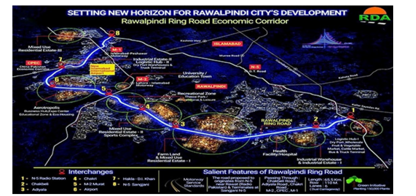
The present study investigates the groundwater potential of the Khasala Service Area along the Rawalpindi Ring Road (Figure 1) through the integration of geophysical well logging, remote sensing, and Artificial Intelligence (AI)-assisted interpretation for hydrogeological characterization and sustainable groundwater exploration. A trial borehole was drilled to characterize subsurface lithology and identify productive aquifer zones using Short Normal (SN), Long Normal (LN) and Spontaneous Potential (SP) geophysical logs. The hydrogeological assessment focused on lithological variability, permeability, aquifer continuity, and groundwater storage characteristics, identifying coarse-grained sand, gravel, and boulder formations as the principal groundwaterbearing units. The novelty of this study lies in integrating borehole geophysical data with AI-assisted interpretation and remote sensing to enhance lithological classification, aquifer delineation, groundwater potential assessment, and preliminary groundwater yield estimation in the Rawalpindi Ring Road corridor, where such a multidisciplinary framework has not previously been reported. Unlike conventional groundwater investigations that rely primarily on borehole interpretation, the proposed framework combines geophysical logging with satellite-derived hydrogeological information to improve interpretation reliability, reduce uncertainty, and support regional groundwater assessment. The integration of AI, remote sensing, and geophysical well logging also provides a scalable and transferable approach for groundwater exploration, infrastructure planning and sustainable waterresource management in rapidly urbanizing and semi-arid regions of Pakistan.
Figure 1:Location map of the Khasala Service Area along Rawalpindi Ring Road, Punjab, Pakistan.
Literature Review
Geophysical methods have been extensively used for groundwater exploration throughout the world because they provide rapid, economical, and non-destructive information regarding subsurface geological and hydrogeological conditions. Among the various geophysical techniques, electrical resistivity methods are considered highly effective for identifying groundwater-bearing formations due to the significant differences in electrical properties between permeable aquifers and impermeable clay-rich formations [13]. Groundwater occurrence within subsurface formations strongly influences resistivity values because lithological composition, porosity, permeability and water saturation directly affect the movement of electrical current through geological materials [14]. Researchers have successfully utilized resistivity surveys, vertical electrical sounding, electrical resistivity tomography, and borehole geophysical logging for aquifer identification, groundwater depth estimation and lithological interpretation in both alluvial and hard rock environments [15]. The effectiveness of resistivity-based investigations has been demonstrated in numerous hydrogeological studies where coarse-grained formations such as sand and gravel deposits exhibited relatively high resistivity values associated with freshwater saturation, whereas clay formations showed comparatively lower resistivity due to their higher moisture content and ion concentration [16]. These techniques are particularly useful in semi-arid regions where groundwater resources are hidden beneath complex sedimentary sequences and accurate subsurface characterization is necessary for sustainable water resource management [17]. Consequently, geophysical exploration methods have become essential tools for groundwater assessment, environmental investigations, and hydrogeological studies associated with urban development and water supply planning [18]. Electrical resistivity investigations are widely recognized for their ability to delineate aquifer geometry and identify groundwater recharge zones within heterogeneous geological formations [19]. Modern hydrogeophysical studies increasingly combine geophysical datasets with geological observations to improve aquifer interpretation accuracy and reduce uncertainty in groundwater exploration projects [20]. The continuous advancement of geophysical technologies has significantly improved the efficiency and reliability of groundwater investigations in sedimentary and alluvial environments.
Borehole geophysical logging techniques play a critical role in hydrogeological investigations because they provide continuous vertical records of subsurface formations and enable detailed evaluation of aquifer properties and lithological boundaries. Logging methods such as Short Normal (SN), Long Normal (LN), and Spontaneous Potential (SP) are widely applied in groundwater exploration for identifying water-bearing formations, estimating aquifer thickness, and analyzing formation permeability [21]. SN resistivity logs are generally used to investigate shallow formation characteristics near the borehole wall, while LN logs provide information regarding deeper formation resistivity and aquifer continuity [22]. Spontaneous Potential logs are particularly useful for detecting permeable formations, fluid movement, and lithological variations associated with groundwater-bearing zones [23]. Borehole geophysical logging also assists hydrogeologists in evaluating porosity distribution, formation saturation, and sediment composition within subsurface layers [24]. Several researchers have reported that the integration of multiple logging techniques improves the reliability of aquifer interpretation and reduces uncertainty in groundwater investigations [25]. The continuous nature of borehole log data allows detailed identification of permeable and impermeable formations, which is often difficult to achieve through conventional drilling records alone [17]. Geophysical logging data are also extensively used for well design, screen placement, and groundwater yield estimation in water supply projects [14]. Borehole resistivity logs are considered particularly effective in alluvial aquifers because they provide clear differentiation between coarse-grained and clay-rich formations [19]. Therefore, borehole geophysical logging has become one of the most reliable and cost-effective techniques for groundwater exploration, aquifer characterization and well development in sedimentary environments.
Artificial Intelligence (AI) and Machine Learning (ML) technologies have recently emerged as powerful tools in hydrogeological investigations due to their ability to process large datasets efficiently and identify hidden patterns associated with groundwater occurrence and aquifer behavior. AI-based techniques are increasingly being used for groundwater potential mapping, lithological classification, aquifer prediction, groundwater level forecasting, contamination assessment, and water quality analysis [20]. Machine learning algorithms such as Artificial Neural Networks (ANN), Random Forest (RF), Support Vector Machines (SVM) and Deep Learning models have demonstrated excellent performance in analyzing hydrogeological and geophysical datasets because they can model complex nonlinear relationships between geological variables and groundwater conditions [21]. Several studies have shown that AI-assisted hydrogeological analysis provides more accurate predictions compared to traditional statistical and manual interpretation methods [22]. AI models can rapidly analyze resistivity data, pumping test results, geological information, and remote sensing datasets to generate predictive groundwater maps and identify favorable drilling locations [23]. The application of AI in hydrogeology has also improved groundwater management practices by enabling automated data analysis, intelligent forecasting, and decision support systems for sustainable aquifer utilization [24]. AI-assisted systems reduce interpretation uncertainty and improve drilling success rates by recognizing patterns that are difficult to identify through conventional hydrogeological methods [25]. Deep learning algorithms have been successfully applied in geophysical interpretation for automated lithological classification and groundwater occurrence prediction [16]. The integration of AI with geophysical techniques has introduced a modern scientific approach for groundwater exploration in water-stressed and rapidly urbanizing regions [18]. Despite these advancements, the application of AI technologies in hydrogeological studies within Pakistan remains relatively limited, particularly in groundwater exploration associated with major infrastructure projects.
The integration of Artificial Intelligence into geophysical logging interpretation has significantly transformed subsurface investigations by improving interpretation accuracy, reducing uncertainty, and accelerating data analysis processes. AI-assisted geophysical interpretation offers several advantages including automated lithological classification, faster processing of geophysical logs, real-time aquifer identification, and enhanced groundwater yield prediction [13]. Traditional interpretation of geophysical logs often depends heavily on expert judgment and manual analysis, which may lead to inconsistencies and interpretation errors when dealing with complex subsurface conditions [15]. In contrast, AI models can analyze large volumes of resistivity and logging data simultaneously while recognizing subtle patterns and nonlinear relationships associated with groundwater occurrence that may not be easily detectable through conventional methods [22]. Deep learning and neural network approaches have been successfully applied in several studies for automated interpretation of resistivity logs and classification of groundwater-bearing formations [24]. AI-assisted systems can further support drilling operations by providing real-time decision-making regarding drilling depth, aquifer targeting, and groundwater productivity estimation [19]. Intelligent geophysical interpretation frameworks contribute to sustainable groundwater resource management by reducing drilling failures, optimizing exploration costs, and improving groundwater extraction strategies [17]. AI-based predictive models are increasingly being integrated with GIS and remote sensing technologies for comprehensive groundwater potential mapping and hydrogeological assessment [21]. The growing integration of AI with geophysical techniques represents a major advancement in hydrogeological research and provides a modern framework for groundwater exploration in semi-arid environments [25]. Therefore, AI-assisted geophysical investigations are expected to play an increasingly important role in future groundwater exploration and sustainable water resource management practices.
Groundwater investigations conducted for large-scale transportation corridors should not be considered solely as hydrogeological assessments but also as an integral component of infrastructure planning and geotechnical engineering. Subsurface lithology, groundwater occurrence, and soil saturation significantly influence foundation stability, differential settlement, pavement performance, and long-term structural safety [26]. Previous studies have demonstrated that soil–structure interaction (SSI) plays an important role in determining the response of reinforced concrete and steel structures under varying subsurface conditions, emphasizing the need for reliable characterization of geological formations prior to infrastructure development [27]. In rapidly urbanizing regions, hydrogeological investigations therefore provide essential baseline information for foundation design, construction planning and risk mitigation [28]. Furthermore, recent advances in remote sensing, Geographic Information Systems (GIS), and Artificial Intelligence have enabled integrated regional-scale assessment of terrain characteristics, land-use change, drainage patterns, lineament density, and groundwater recharge zones [29]. When combined with borehole geophysical logging, these geospatial technologies improve the understanding of both local subsurface conditions and regional hydrogeological variability, thereby supporting sustainable infrastructure development and groundwater resource management [30].
Materials and Methods
Borehole drilling
A trial borehole was drilled at the Khasala Service Area along Rawalpindi Ring Road for the purpose of groundwater exploration and water supply assessment under the present hydrogeological investigation. The drilling operation was conducted to evaluate subsurface lithological conditions and identify productive groundwater-bearing formations suitable for long-term water extraction and supply requirements. The borehole reached a total depth of 515 feet (157 meters), penetrating various alluvial and sedimentary formations consisting mainly of clay, sand, gravel, boulders, sandstone, and shale deposits. During drilling activities, continuous lithological observations were recorded in order to identify variations in formation characteristics, sediment composition, grain size distribution, and permeability conditions at different depth intervals. The drilling process provided essential geological information regarding aquifer occurrence, confining layers, and groundwater-bearing formations within the study area. The borehole data further assisted in correlating lithological changes with geophysical logging responses for accurate hydrogeological interpretation and aquifer characterization. The drilling investigation also enabled the identification of suitable screen placement zones for groundwater abstraction and well development purposes. The geological formations encountered during drilling indicated significant lithological heterogeneity associated with alluvial depositional environments commonly observed within the Potohar Plateau region. Therefore, the borehole drilling operation formed the fundamental basis for subsequent geophysical logging and AI-assisted hydrogeological analysis conducted during the present study.
Geophysical logging techniques
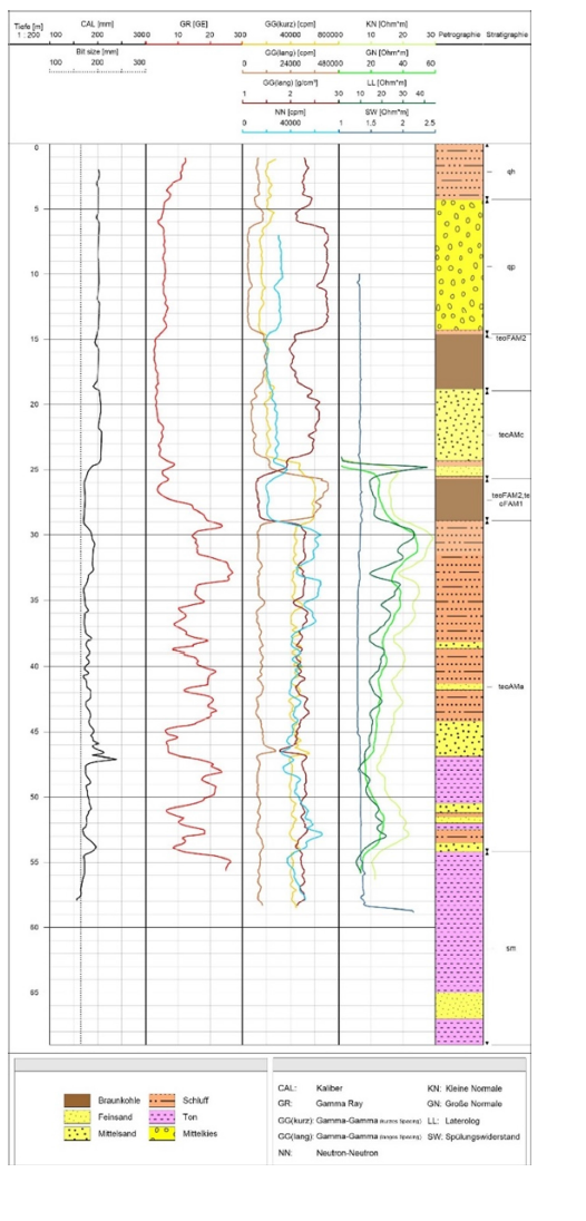
Geophysical well logging was conducted after completion of drilling operations in order to evaluate subsurface formation characteristics and identify productive groundwater-bearing zones within the investigated borehole (Figure 2). The logging investigation involved the application of Short Normal (SN), Long Normal (LN), and Spontaneous Potential (SP) geophysical logging techniques because these methods are widely recognized for their effectiveness in hydrogeological investigations and aquifer identification. Geophysical logging provides continuous records of subsurface electrical properties and enables detailed interpretation of lithological boundaries, formation permeability, groundwater saturation, and aquifer continuity at different depths. The acquired geophysical data were carefully analyzed to distinguish permeable formations from impermeable clay-rich layers based on variations in resistivity and spontaneous potential responses. The integration of multiple logging techniques improved the reliability and accuracy of hydrogeological interpretation by providing complementary information regarding shallow and deeper formation conditions. Geophysical logs were also correlated with drilling observations and lithological records to enhance aquifer identification and groundwater potential assessment. The application of resistivitybased logging methods enabled detailed characterization of coarsegrained and fine-grained formations associated with groundwater occurrence within the study area. Furthermore, the logging investigation provided essential information regarding formation saturation, sediment composition, and hydrogeological conditions influencing groundwater storage and movement. Therefore, geophysical logging formed a critical component of the present groundwater exploration study and significantly contributed to accurate aquifer evaluation and subsurface characterization.
Figure 2:Location map of the Khasala Service Area along Rawalpindi Ring Road, Punjab, Pakistan.
Processing and interpretation of geophysical logging data
The Short Normal (SN), Long Normal (LN), and Spontaneous Potential (SP) logs were processed and interpreted to identify lithological variations and groundwater-bearing formations within the investigated borehole. The SN and LN resistivity logs were analysed to distinguish between permeable and impermeable formations based on variations in apparent electrical resistivity, whereas the SP log was used to identify permeable zones by detecting natural electrochemical potential differences generated between the borehole fluid and surrounding formations. The integrated interpretation of these geophysical responses, together with lithological observations obtained during drilling, enabled the delineation of potential aquifer intervals. Log responses were examined continuously throughout the borehole depth, and aquifer zones were interpreted where relatively higher resistivity values coincided with significant SP deflections and coarse-grained lithological units such as sand, gravel, and boulders. Although the geophysical logs provided a reliable basis for preliminary aquifer identification, the interpreted intervals remain subject to uncertainties associated with lithological heterogeneity, borehole conditions, and measurement variability. Therefore, the identified aquifer zones should be regarded as preliminary interpretations requiring validation through hydraulic testing and additional field investigations.
Short Normal (SN) logging
Short Normal logging was used during the present investigation to measure shallow formation resistivity and identify lithological changes occurring near the borehole wall. This logging technique is particularly useful for evaluating the electrical properties of formations located immediately adjacent to the borehole and provides valuable information regarding near-surface lithological variations and groundwater conditions. SN logging is highly sensitive to changes in sediment composition, porosity, permeability, and water saturation within shallow subsurface formations. In the present study, SN resistivity measurements assisted in distinguishing coarse-grained formations such as sand and gravel deposits from clay-rich layers based on their electrical characteristics. Higher resistivity values generally indicated permeable formations saturated with freshwater, whereas lower resistivity values were associated with clay formations containing higher moisture and ion concentrations. The interpretation of SN logs also helped identify potential aquifer zones and evaluate the continuity of permeable formations within the borehole profile. The shallow investigation depth of SN logging provided detailed information regarding formation conditions immediately surrounding the borehole, which is important for understanding drilling-induced disturbances and lithological transitions. The acquired SN logging data were integrated with other geophysical and lithological information to improve overall hydrogeological interpretation and aquifer characterization. Therefore, Short Normal logging served as an important technique for identifying lithological boundaries and evaluating shallow formation resistivity conditions within the study area.
Long Normal (LN) logging
Long Normal logging was conducted to investigate deeper formation resistivity and evaluate aquifer continuity, groundwater saturation, and subsurface lithological characteristics beyond the immediate borehole wall environment. Unlike SN logging, LN logging possesses greater depth penetration and therefore provides information regarding the electrical properties of formations located farther from the borehole. This characteristic makes LN logging particularly effective for identifying extensive groundwater-bearing formations and evaluating the continuity of permeable aquifer zones within sedimentary environments. In the present study, LN resistivity logs were used to distinguish coarsegrained permeable formations from impermeable clay layers based on variations in electrical resistivity associated with groundwater saturation and lithological composition. Higher LN resistivity values were generally interpreted as indicators of freshwaterbearing sand, gravel, and boulder formations possessing relatively high permeability and transmissivity. Conversely, lower resistivity values were associated with clay-rich formations exhibiting low permeability and limited groundwater potential. The interpretation of LN logs also contributed to understanding the thickness, extent, and hydrogeological characteristics of productive aquifer zones encountered within the borehole profile. LN logging further assisted in identifying major groundwater reservoirs and evaluating subsurface conditions controlling groundwater movement and storage within the study area. The acquired data were correlated with SN and SP logging responses to improve interpretation accuracy and reduce uncertainty in aquifer identification. Consequently, Long Normal logging provided essential information regarding deeper subsurface resistivity conditions and played a major role in groundwater potential assessment.
Spontaneous Potential (SP) logging
Spontaneous Potential logging was employed during the present investigation to identify permeable formations, evaluate fluid movement, and distinguish aquifer zones from impermeable clay-rich formations within the borehole. SP logging measures naturally occurring electrical potentials generated due to electrochemical and electrokinetic processes between borehole fluids and surrounding geological formations. Variations in spontaneous potential responses are strongly influenced by formation permeability, fluid salinity, lithological composition, and groundwater movement within subsurface layers. In the present study, SP logs were particularly useful for detecting water-bearing formations composed of sand, gravel, and boulder deposits because these permeable materials generally produce characteristic SP deflections compared to impermeable clay formations. The interpretation of SP data enabled identification of productive aquifer intervals and provided important information regarding subsurface hydrogeological conditions associated with groundwater occurrence. SP logging also assisted in correlating lithological variations with resistivity measurements obtained from SN and LN logs, thereby improving overall hydrogeological interpretation and aquifer delineation. The acquired SP responses were further analyzed to identify formation boundaries, evaluate groundwater saturation conditions, and assess fluid movement within permeable zones. The integration of SP logging with resistivity-based methods significantly enhanced the reliability of groundwater exploration and reduced uncertainty in aquifer identification. Therefore, Spontaneous Potential logging represented an essential component of the geophysical investigation and contributed substantially to understanding the hydrogeological behavior of subsurface formations within the study area.
Principles of resistivity interpretation
The interpretation of electrical resistivity data in hydrogeological investigations is based on the principle that different geological formations exhibit distinct electrical properties depending upon their mineral composition, porosity, permeability, water saturation and fluid salinity conditions. Electrical resistivity represents the resistance offered by subsurface materials to the flow of electrical current and is strongly influenced by the physical and chemical characteristics of geological formations. In groundwater investigations, resistivity measurements are widely used for distinguishing permeable aquifer formations from impermeable clay-rich layers because groundwater occurrence significantly affects formation conductivity and resistivity values. Clay formations generally exhibit relatively low resistivity due to their high moisture retention capacity and elevated ion concentration, whereas coarse-grained formations such as sand, gravel, and boulders saturated with freshwater display comparatively higher resistivity values. Variations in porosity and permeability also influence groundwater storage and movement within subsurface formations, thereby affecting measured resistivity responses. In the present study, resistivity interpretation involved detailed analysis of SN and LN log responses combined with lithological observations and SP measurements to identify productive groundwater-bearing zones and evaluate aquifer continuity. The interpretation process further considered formation saturation, sediment composition, and groundwater salinity conditions influencing subsurface electrical properties. The integration of multiple geophysical datasets improved interpretation accuracy and enabled reliable characterization of lithological boundaries and hydrogeological conditions within the study area. Therefore, resistivity interpretation formed a fundamental basis for identifying aquifer zones and assessing groundwater potential during the present investigation.
AI-Integrated interpretation framework
Artificial Intelligence concepts were integrated into the present hydrogeological investigation in order to improve geophysical interpretation accuracy, enhance aquifer prediction capability, and develop a modern framework for intelligent groundwater exploration. The AI-integrated interpretation framework involved systematic processing and analysis of geophysical logging data using machine learning concepts capable of identifying hidden relationships between formation resistivity and groundwater occurrence. The first stage of the framework involved data acquisition through geophysical logging measurements and detailed borehole lithological recording during drilling operations. These datasets included resistivity values, formation characteristics, lithological information, and hydrogeological observations collected at various depth intervals within the borehole. The second stage involved data preprocessing techniques including resistivity normalization, noise filtering, feature extraction, and organization of datasets into machine-readable formats suitable for AI-based analysis. The third stage included conceptual implementation of machine learning algorithms such as Artificial Neural Networks (ANN), Random Forest (RF), and Support Vector Machines (SVM) for automated lithological classification, aquifer identification, and groundwater prediction. These AI models possess the capability to analyze complex nonlinear relationships within geophysical datasets and generate predictive interpretations regarding groundwater occurrence and aquifer productivity. The final stage of the framework involved aquifer prediction and hydrogeological assessment through classification of permeable formations, impermeable layers, productive groundwater-bearing zones, and expected groundwater yield potential. The integration of AI concepts into geophysical investigations significantly improves interpretation efficiency, reduces uncertainty, enhances drilling success rates, and supports sustainable groundwater resource management. Therefore, the proposed AI-integrated framework represents an innovative approach for future hydrogeological investigations and groundwater exploration projects in semi-arid regions of Pakistan.
Subsurface lithological profile
Table 1:Subsurface Lithological Profile.
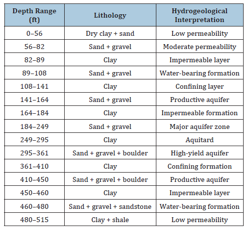
The subsurface lithological profile interpreted from drilling observations and geophysical logging data revealed a highly heterogeneous sequence of alluvial and sedimentary formations extending to a total borehole depth of 515 feet (Table 1). The upper section of the borehole from 0–56 feet mainly consisted of dry clay mixed with sand deposits characterized by relatively low permeability and limited groundwater potential due to the dominance of fine-grained materials. Between depths of 56–82 feet, formations composed of sand and gravel were encountered, indicating moderate permeability and favorable groundwater movement conditions compared to overlying clay-rich layers. Clay formations observed between 82–89 feet and 108–141 feet acted as impermeable and confining layers restricting groundwater movement between adjacent permeable zones. Productive aquifer formations consisting of sand and gravel deposits were identified between 141–164 feet and 184–249 feet, representing favorable groundwater-bearing intervals with relatively high permeability and transmissivity characteristics. Another thick clay layer between 249–295 feet acted as an aquitard separating upper and deeper groundwater-bearing formations within the borehole profile.
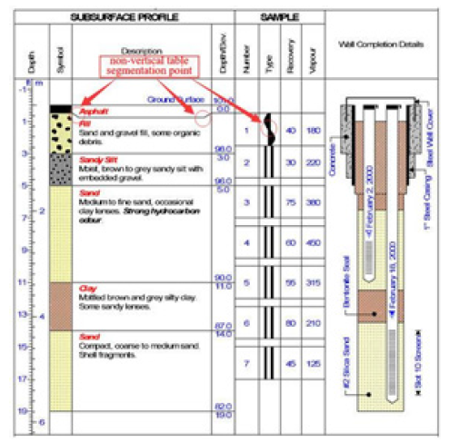
The deeper section of the borehole revealed highly productive aquifer formations associated with coarse-grained sand, gravel, and boulder deposits extending between depths of 295-361 feet and 410-450 feet. These formations were interpreted as major groundwater reservoirs due to their high permeability, significant thickness, and interconnected pore spaces capable of storing and transmitting groundwater efficiently. Clay-rich formations between 361-410 feet and 450-460 feet functioned as confining layers restricting vertical groundwater movement and separating productive aquifers occurring at different depth intervals. Another water-bearing formation composed of sand, gravel and sandstone deposits was identified between 460-480 feet, indicating additional groundwater potential within the deeper section of the borehole. The final section of the borehole extending from 480-515 feet mainly consisted of clay and shale formations characterized by low permeability and limited groundwater occurrence (Figure 3). Overall, the interpreted lithological profile demonstrated the presence of multiple productive aquifer zones separated by impermeable clay layers typical of alluvial depositional environments within the Potohar Plateau region. The identified coarse-grained formations possess favorable hydrogeological characteristics and indicate moderate to high groundwater potential suitable for long-term water supply development within the study area.
Figure 3:Interpreted lithological profile of the investigated borehole.
Results
Lithological interpretation
The interpretation of geophysical well logging data revealed a highly heterogeneous subsurface lithological sequence consisting of alternating layers of clay, sand, gravel, boulders, sandstone and shale formations within the investigated borehole profile. The upper and intermediate sections of the borehole were dominated by clayrich formations characterized by relatively low resistivity values and limited permeability conditions, indicating poor groundwater movement and restricted water storage potential. In contrast, several coarse-grained formations composed of sand, gravel, and boulder deposits exhibited comparatively higher resistivity responses associated with freshwater saturation and enhanced groundwater occurrence. The lithological interpretation further demonstrated that impermeable clay layers acted as confining formations separating permeable groundwater-bearing zones occurring at different depth intervals within the borehole profile. Sandstone formations encountered within the deeper sections of the borehole also contributed to groundwater occurrence due to their moderate porosity and permeability characteristics. The interpretation of SN, LN and SP logs enabled accurate delineation of lithological boundaries and improved understanding of subsurface hydrogeological conditions controlling groundwater movement and storage. The identified geological sequence reflects typical alluvial depositional environments commonly observed within semi-arid regions of the Potohar Plateau. The variation in lithological composition and formation thickness indicates complex sedimentary deposition processes that significantly influence groundwater distribution within the study area. The interpreted subsurface profile further confirmed the presence of multiple aquifer systems separated by confining clay layers, thereby creating favorable hydrogeological conditions for groundwater accumulation. Therefore, the lithological interpretation provided essential information for identifying productive aquifer zones and evaluating groundwater potential within the Khasala Service Area.
Identification of aquifer zones
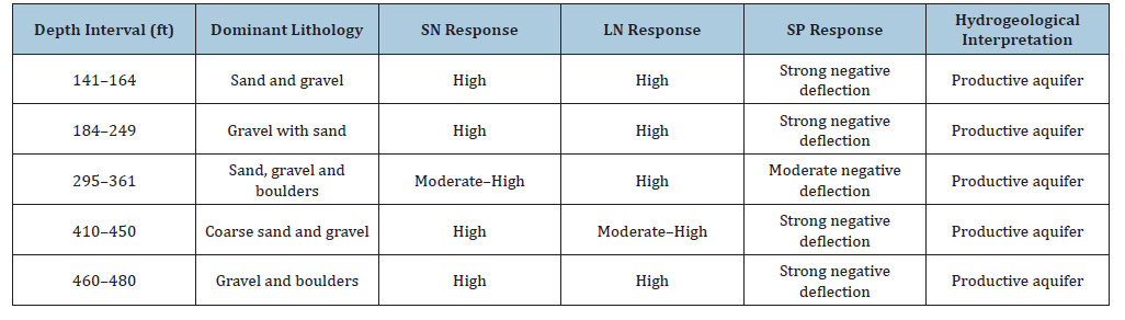
Detailed analysis of geophysical logging data and lithological observations resulted in the identification of several productive groundwater-bearing aquifer zones occurring at different depths within the investigated borehole (Table 2). The first productive aquifer zone was identified between depths of 141-164 feet and mainly consisted of permeable sand and gravel deposits possessing moderate groundwater storage potential and favorable hydraulic conductivity characteristics. The second aquifer zone extending from 184-249 feet was interpreted as a major groundwaterbearing formation composed predominantly of coarse-grained sand and gravel materials exhibiting relatively high permeability and transmissivity conditions. Another highly productive aquifer zone was encountered between depths of 295-361 feet where thick sequences of sand, gravel, and boulder deposits indicated excellent groundwater storage capacity and enhanced groundwater movement within interconnected pore spaces. The fourth productive aquifer zone identified between 410-450 feet also consisted of coarse-grained sand, gravel and boulder formations characterized by favorable hydrogeological conditions suitable for groundwater extraction and long-term water supply development. Additionally, another water-bearing formation was encountered between depths of 460-480 feet where sand, gravel, and sandstone deposits exhibited moderate to good groundwater occurrence and permeability characteristics. The identified aquifer zones were separated by impermeable clay formations acting as confining layers restricting vertical groundwater movement and enhancing aquifer protection from surface contamination. The thickness, continuity, and lithological composition of the identified aquifers indicate significant groundwater storage potential within the study area. The integration of geophysical logs with drilling observations significantly improved the reliability of aquifer delineation and hydrogeological interpretation. Therefore, the identified aquifer zones represent important groundwater resources capable of supporting future municipal and commercial water supply requirements within the rapidly developing Rawalpindi Ring Road region.
Table 2:Quantitative summary of geophysical logging responses used for aquifer delineation.
Groundwater potential
The hydrogeological investigation indicated that the deeper sand, gravel, and boulder formations possess highly favorable characteristics for groundwater occurrence, storage, and transmission within the study area. These coarse-grained formations exhibit relatively high porosity and permeability due to their larger grain size distribution and interconnected pore spaces, which facilitate efficient groundwater movement and accumulation within subsurface aquifers. The major groundwater-bearing zones identified during geophysical interpretation demonstrated significant aquifer thickness and lateral continuity, suggesting moderate to good groundwater potential suitable for sustainable groundwater extraction and water supply development. The deeper aquifer systems occurring between 295-361 feet and 410- 450 feet were interpreted as the most productive groundwater reservoirs because of their extensive thickness, coarse sediment composition, and enhanced transmissivity characteristics. The presence of impermeable clay layers between productive aquifers further improves groundwater storage conditions by restricting vertical water movement and minimizing groundwater losses from permeable formations. Hydrogeological conditions observed within the study area are typical of layered alluvial aquifer systems where groundwater occurrence is strongly controlled by lithological heterogeneity and sediment permeability distribution. The groundwater potential assessment also indicated that the identified aquifers possess sufficient recharge and storage capacity to support future municipal and commercial groundwater utilization. Furthermore, the geophysical investigation demonstrated that the hydrogeological framework of the area is highly favorable for groundwater abstraction due to the occurrence of multiple productive aquifer horizons within the subsurface profile. The identified coarse-grained formations are expected to provide stable groundwater yields under controlled pumping conditions and sustainable extraction strategies. Therefore, the Khasala Service Area possesses moderate to good groundwater potential capable of supporting long-term water resource development associated with future infrastructural and urban expansion.
Estimated groundwater yield
The preliminary groundwater yield of the investigated borehole was inferred from the interpretation of geophysical well logging responses, lithological characteristics, aquifer thickness, and the distribution of permeable formations identified during the hydrogeological investigation. Based on the interpreted aquifer properties and observed geological conditions, the borehole is estimated to possess a preliminary groundwater yield of approximately 4000-5000 gallons per hour (gph), indicating moderate to good groundwater potential. However, this estimate should not be interpreted as a confirmed sustainable groundwater yield because it is derived solely from lithological interpretation and geophysical logging responses. The absence of pumping-test data precludes direct determination of aquifer transmissivity, storativity, specific capacity, and long-term well performance; therefore, the reported yield should be regarded as an initial hydrogeological approximation requiring future validation through step-drawdown and constant-rate pumping tests. The deeper aquifer formations composed of sand, gravel, and boulder deposits contributed significantly to the estimated discharge capacity because these formations possess relatively high transmissivity and groundwater storage characteristics. The identified groundwater yield is considered suitable for commercial, municipal, and infrastructural water supply applications associated with future development projects along Rawalpindi Ring Road. The occurrence of multiple productive aquifer zones within the borehole profile further enhances groundwater extraction potential by allowing groundwater abstraction from different depth intervals depending upon operational requirements and pumping conditions. The estimated discharge also reflects favorable hydrogeological conditions associated with layered alluvial aquifer systems where coarse-grained permeable formations store and transmit groundwater efficiently. The interpretation of geophysical logging data enabled reliable estimation of groundwater productivity by correlating resistivity responses with formation permeability and groundwater saturation characteristics. However, the actual long-term groundwater yield may vary depending upon seasonal recharge conditions, pumping rates, aquifer connectivity, and groundwater management practices implemented within the region. The estimated discharge values nevertheless indicate that the investigated site possesses sufficient groundwater potential to support sustainable water extraction and future water supply development. Therefore, the hydrogeological investigation indicates that the Khasala Service Area possesses promising groundwater potential for future groundwater development and commercial water supply utilization. Nevertheless, confirmation of sustainable groundwater availability requires comprehensive hydraulic testing, including pumping tests, groundwater-level monitoring, and long-term aquifer performance evaluation before large-scale groundwater abstraction is undertaken.
AI-Based interpretation outcomes
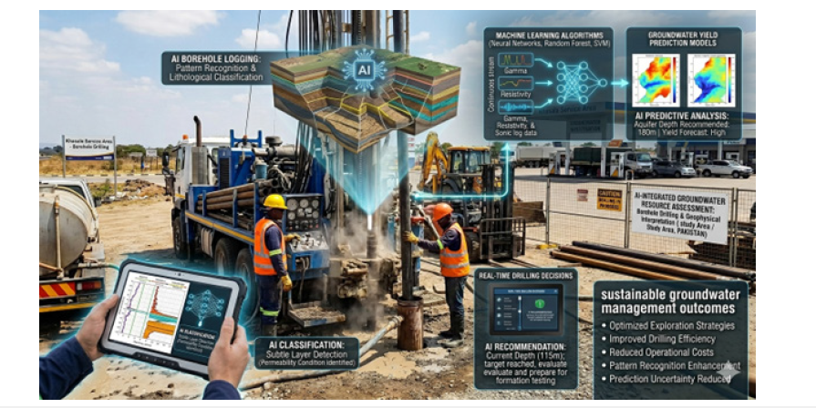
The conceptual integration of Artificial Intelligence into geophysical interpretation demonstrated significant potential for improving hydrogeological investigations, groundwater prediction and aquifer characterization within the study area. AI-assisted interpretation techniques can enhance lithological classification accuracy by automatically analyzing geophysical logging data and identifying subtle relationships between resistivity values and subsurface geological formations that may not be easily recognized through conventional interpretation methods. Machine learning algorithms such as Artificial Neural Networks, Random Forest models, and Support Vector Machines possess the capability to process large geophysical datasets rapidly while reducing interpretation time and minimizing human-related analytical errors (Figure 4). AI-based interpretation further enables the identification of hidden aquifer patterns and complex nonlinear hydrogeological relationships associated with groundwater occurrence and formation permeability conditions. The integration of intelligent data processing techniques can significantly improve groundwater yield prediction accuracy by analyzing multiple hydrogeological variables simultaneously and generating predictive groundwater models for future exploration projects. AI-assisted systems can also support real-time drilling decisions by providing automated recommendations regarding drilling depth, aquifer targeting, and formation evaluation during groundwater exploration operations. Furthermore, AI integration reduces uncertainty in hydrogeological investigations by improving pattern recognition and enhancing predictive analysis capabilities associated with subsurface geological interpretation. The use of AI-based techniques additionally contributes to sustainable groundwater management through optimized groundwater exploration strategies, improved drilling efficiency, and reduced operational costs. The outcomes of the present study indicate that AI-assisted geophysical interpretation represents a highly promising approach for future groundwater exploration projects in Pakistan and other semi-arid regions experiencing increasing water scarcity and groundwater demand. Therefore, the integration of Artificial Intelligence with geophysical logging methods provides a modern and efficient framework for intelligent groundwater resource assessment and sustainable hydrogeological investigations.
Fgure 4:a) Schematic view of experimental setup, b) A view of the model pile and the soil container (barrel) used in this experiment.
Discussion
Hydrogeological significance
The results of the present investigation indicate that the Khasala Service Area contains multiple productive groundwaterbearing aquifers separated by impermeable clay confining layers, thereby forming a layered aquifer system characteristic of alluvial depositional environments. Such hydrogeological conditions are commonly observed within semi-arid sedimentary basins where alternating sequences of permeable and impermeable formations control groundwater occurrence, movement, and storage within the subsurface environment (Table 3). The identified clay-rich formations act as confining units that restrict vertical groundwater movement and provide natural protection against contamination of deeper aquifers from surface pollutants and anthropogenic activities. The occurrence of several productive aquifer zones within different depth intervals further demonstrates the significant groundwater potential associated with coarse-grained sedimentary formations present in the study area [7]. The hydrogeological framework interpreted from geophysical logging and lithological analysis indicates favorable groundwater recharge and storage conditions within permeable sand, gravel, and boulder deposits. The layered aquifer system identified during the investigation also improves groundwater sustainability because groundwater extraction can be distributed across multiple aquifers depending upon pumping requirements and operational conditions [19]. Furthermore, the confining clay layers enhance groundwater retention and minimize rapid groundwater depletion within productive aquifer zones. The hydrogeological significance of the study lies in its ability to provide detailed subsurface information required for groundwater development, aquifer management, and future water supply planning within rapidly urbanizing regions [21]. The interpreted aquifer systems additionally represent important freshwater resources capable of supporting future municipal and commercial water demands associated with infrastructural expansion along Rawalpindi Ring Road. Therefore, the present investigation provides valuable hydrogeological insights regarding groundwater occurrence and aquifer distribution within the Potohar Plateau region.
Table 3:Identified Aquifer Zones and Hydrogeological Interpretation.

The hydrogeological framework identified in the present study has direct implications for future infrastructure development along the Rawalpindi Ring Road corridor. Variations in lithology, groundwater occurrence, and aquifer distribution influence foundation conditions, excavation stability, pavement performance, and long-term serviceability of transportation infrastructure. Previous investigations on soil–structure interaction have demonstrated that subsurface conditions significantly affect structural behaviour under both static and dynamic loading conditions. Although the present investigation primarily focuses on groundwater exploration, the interpreted lithological profile provides valuable geotechnical information that may assist future foundation investigations and infrastructure planning. Moreover, integrating remote sensing datasets, including Digital Elevation Models (DEMs), multispectral satellite imagery, land-use/landcover mapping, and drainage-network extraction, with borehole geophysical logging can improve regional characterization of groundwater recharge, geomorphology, and terrain conditions. Such multi-source integration enables more reliable site selection, groundwater management, and sustainable infrastructure planning, particularly in rapidly developing regions of the Potohar Plateau.
Comparison with previous hydrogeological studies in the potohar plateau
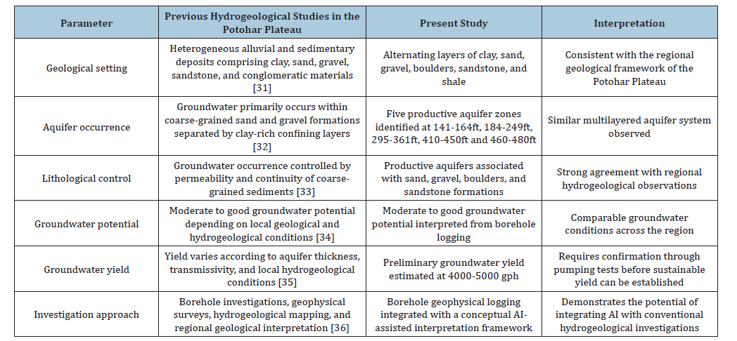
The hydrogeological characteristics identified in the present investigation are generally consistent with the regional geological framework of the Potohar Plateau, where groundwater predominantly occurs within heterogeneous alluvial and sedimentary deposits comprising alternating layers of clay, sand, gravel, boulders, and sandstone. The productive aquifer intervals delineated between 141-164ft, 184-249ft, 295-361ft, 410-450ft and 460-480ft indicate a multilayered aquifer system in which coarse-grained sediments constitute the principal groundwaterbearing formations, while intervening clay-rich strata function as aquitards that restrict vertical groundwater movement and enhance aquifer confinement. Similar hydrogeological conditions have been reported in previous investigations conducted across the Potohar Plateau and surrounding regions, where groundwater occurrence is primarily controlled by lithological heterogeneity, sediment permeability, and the distribution of alluvial deposits. The deeper aquifer horizons encountered in the present study may reflect local variations in depositional history, fluvial processes, and subsurface geological architecture associated with the Rawalpindi Ring Road corridor. Furthermore, the estimated groundwater yield of 4000–5000 gallons per hour (gph) suggests moderate to good groundwater potential; however, this value should be interpreted as a preliminary hydrogeological estimate derived from borehole lithology and geophysical logging responses rather than a confirmed sustainable yield, pending validation through pumping tests and long-term aquifer performance analyses. The comparison between the present findings and previous regional hydrogeological investigations highlights the consistency of the identified lithological succession, aquifer distribution, and groundwater potential within the Potohar Plateau (Table 4).
Table 4:Comparison of the Present Investigation with Previous Hydrogeological Studies Conducted in the Potohar Plateau.
Recent advances in remote sensing, Geographic Information Systems (GIS), and Artificial Intelligence (AI) have substantially enhanced regional hydrogeological investigations by enabling the integration of borehole observations with satellite-derived datasets, including Digital Elevation Models (DEMs), land-use/land-cover, drainage density, lineament density, slope, and geomorphological characteristics. These geospatial datasets provide valuable information regarding groundwater recharge, structural controls, watershed characteristics, and regional aquifer distribution that cannot be inferred from a single borehole alone. Consequently, integrating geophysical well logging with remote sensing-derived hydrogeological information and AI-based predictive modelling offers a comprehensive framework for groundwater exploration by improving lithological classification, reducing interpretation uncertainty, and facilitating regional groundwater potential assessment. Such a multidisciplinary approach is particularly valuable for rapidly developing infrastructure corridors, including the Rawalpindi Ring Road, where sustainable groundwater resource management should be integrated with geotechnical planning, infrastructure development, and long-term environmental sustainability.
Validation of formation continuity
The lithological succession interpreted from the geophysical well logs and borehole data indicate the presence of multiple permeable and impermeable formations within the investigated subsurface profile. Although the alternating sequences of clay, sand, gravel, boulders and sandstone are consistent with the regional hydrogeological framework of the Potohar Plateau, the interpretation presented in this study is derived from a single exploratory borehole and therefore represents the hydrogeological conditions at the investigated site only. Consequently, the inferred continuity of the identified aquifer and confining units should be considered site-specific, as the lateral extent of these formations cannot be conclusively established without additional field evidence. Similar hydrogeological investigations emphasize that reliable characterization of aquifer geometry and formation continuity requires the integration of multiple boreholes, regional geological mapping, and complementary geophysical investigations to account for lateral lithological variability within heterogeneous alluvial environments.
To improve confidence in the regional interpretation, future investigations should integrate additional exploratory boreholes, cross-borehole lithological correlation, Electrical Resistivity Tomography (ERT), and remote sensing- and GISbased hydrogeological mapping to evaluate the spatial continuity of aquifer systems across the Rawalpindi Ring Road corridor. Furthermore, satellite-derived datasets, including Digital Elevation Models (DEMs), lineament density, drainage networks, land-use/land-cover, and geomorphological characteristics can complement borehole observations by providing regional information on groundwater recharge, structural controls, and subsurface heterogeneity. The integration of these geospatial datasets with geophysical well logging and AI-assisted predictive modelling would facilitate three-dimensional hydrogeological characterization, reduce interpretation uncertainty and provide a more robust assessment of aquifer continuity for sustainable groundwater development and infrastructure planning.
Preliminary estimation of groundwater yield
The groundwater yield estimated in the present investigation is based on the interpretation of lithological characteristics and geophysical well logging responses, including the distribution and thickness of permeable sand, gravel, and boulder formations. The interpreted aquifer intervals indicate moderate to good groundwater potential, with an estimated yield of approximately 4000–5000 gallons per hour (gph). However, this estimate should be regarded as a preliminary hydrogeological assessment rather than a confirmed sustainable groundwater yield because no pumping tests were conducted to determine aquifer transmissivity, storativity, or long-term well performance. Consequently, the reported yield represents an initial approximation of groundwater availability derived from subsurface geological interpretation and should be interpreted with appropriate caution.
Reliable determination of sustainable groundwater yield requires comprehensive aquifer testing, including step-drawdown tests, constant-rate pumping tests, recovery analyses and groundwater-level monitoring, to quantify hydraulic conductivity, transmissivity, specific capacity and aquifer storage properties. In addition, integrating pumping-test observations with remote sensing-derived groundwater recharge indicators, GIS-based hydrogeological mapping and AI-assisted predictive modelling can substantially improve the estimation of groundwater availability by incorporating both local subsurface conditions and regional recharge dynamics. Such an integrated framework would reduce uncertainty in groundwater resource assessment and provide a more robust basis for sustainable groundwater development and water-resource management along the Rawalpindi Ring Road corridor.
Validation of identified aquifer zones
The aquifer zones identified in the present study were delineated through the integrated interpretation of lithological observations and Short Normal (SN), Long Normal (LN) and Spontaneous Potential (SP) geophysical well logs, providing a reliable preliminary assessment of groundwater-bearing formations within the investigated borehole. Although geophysical well logging is widely recognized as an effective technique for subsurface characterization and aquifer delineation, the interpreted aquifer intervals should be considered preliminary hydrogeological interpretations until verified through independent field investigations. The hydrogeological characteristics inferred from borehole logging therefore represent the conditions at the investigated location and should not be interpreted as definitive confirmation of aquifer productivity or regional hydrogeological continuity.
To improve the reliability of the interpreted aquifer system, future investigations should validate the identified groundwaterbearing zones through step-drawdown and constant-rate pumping tests, groundwater-level monitoring, hydrochemical (water-quality) analyses and additional exploratory boreholes distributed along the Rawalpindi Ring Road corridor. Furthermore, integrating these field observations with remote sensing, Geographic Information Systems (GIS), and Artificial Intelligence (AI) would enable regional assessment of groundwater recharge, aquifer continuity, and groundwater quality by incorporating satellite-derived information on land-use/land-cover, drainage patterns, lineament density, and geomorphological characteristics. Such a multidisciplinary validation framework would reduce interpretation uncertainty, improve confidence in aquifer delineation, and support sustainable groundwater resource management and infrastructure planning.
Importance of coarse-grained formations
The coarse-grained sand, gravel, and boulder formations identified during the present investigation were interpreted as highly favorable groundwater-bearing formations due to their superior hydrogeological characteristics and groundwater storage capacity. These formations possess relatively high porosity resulting from larger grain sizes and interconnected pore spaces that facilitate efficient groundwater accumulation and movement within subsurface aquifers [3]. High permeability conditions observed within coarse-grained deposits enable rapid groundwater flow and improve aquifer transmissivity, thereby supporting sustainable groundwater extraction under pumping conditions. The identified boulder and gravel formations also exhibit enhanced groundwater recharge potential because water can infiltrate and migrate efficiently through permeable sedimentary layers. In contrast, clay-rich formations possess low permeability and restricted groundwater movement due to their fine-grained structure and compact sediment arrangement [15]. The occurrence of thick coarse-grained formations within deeper sections of the borehole significantly contributed to the moderate to high groundwater potential estimated for the study area. The transmissivity characteristics of these aquifers further indicate their suitability for long-term municipal and commercial water supply applications associated with urban development projects. Additionally, the hydrogeological properties of sand and gravel deposits improve groundwater storage efficiency and enhance aquifer productivity under continuous groundwater abstraction conditions [18]. The distribution and continuity of coarse-grained formations identified during the investigation also indicate favorable hydrogeological connectivity between productive aquifer zones within the study area. Therefore, the presence of extensive sand, gravel, and boulder formations represents one of the most important factors controlling groundwater occurrence and aquifer productivity within the investigated region.
Advantages of AI integration
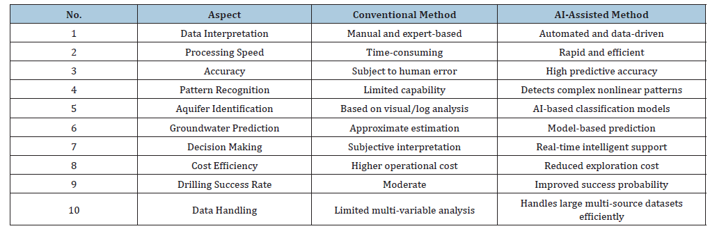
The integration of Artificial Intelligence into geophysical interpretation offers several significant advantages over conventional hydrogeological investigation methods by improving interpretation efficiency, predictive accuracy, and data analysis capability (Table 5). Traditional geophysical interpretation generally relies on manual analysis and expert judgment, which may introduce interpretation uncertainty and inconsistencies when dealing with complex geological conditions and large geophysical datasets. In contrast, AI-assisted interpretation enables automated analysis of resistivity logs and lithological information [21] through intelligent algorithms capable of identifying nonlinear relationships associated with groundwater occurrence and aquifer productivity. AI-based systems significantly reduce interpretation time by rapidly processing geophysical datasets and generating automated predictions regarding lithological classification and groundwater potential [2]. Furthermore, machine learning algorithms improve decision-making reliability by producing datadriven predictions rather than subjective interpretations based solely on human expertise. AI integration also enhances pattern recognition capability by identifying subtle hydrogeological trends and aquifer characteristics that may not be easily detectable through conventional interpretation approaches [8]. The ability of AI models to analyze multiple geological and geophysical variables simultaneously further improves groundwater yield estimation and aquifer prediction accuracy. AI-assisted interpretation additionally supports real-time drilling operations by providing immediate recommendations regarding drilling depth selection, aquifer targeting and groundwater productivity assessment during exploration activities [23]. The application of AI in hydrogeological investigations also contributes to reduced operational costs, improved drilling success rates and optimized groundwater exploration strategies. Therefore, Artificial Intelligence represents a transformative technological advancement capable of significantly improving groundwater investigations and sustainable water resource management practices.
Table 5:Advantages of AI-Assisted Groundwater Exploration [2,8,21,23,36].
Sustainability implications
The integration of Artificial Intelligence into groundwater exploration and hydrogeological investigations possesses significant implications for sustainable water resource management, particularly in semi-arid and water-stressed regions experiencing increasing groundwater demand. AIassisted groundwater investigations can improve drilling success rates by accurately identifying productive aquifer zones and minimizing unsuccessful drilling operations associated with poor hydrogeological interpretation. The use of intelligent data analysis techniques further contributes to reduced exploration costs because AI systems can rapidly process large geophysical datasets and optimize groundwater exploration strategies more efficiently than conventional methods [24]. Sustainable groundwater extraction can also be improved through AI-based prediction models capable of estimating groundwater recharge conditions, aquifer productivity and long-term groundwater availability under different pumping scenarios. AI-assisted hydrogeological systems additionally support long-term aquifer monitoring by continuously analyzing groundwater data and identifying changes in groundwater levels, water quality, and aquifer conditions over time. The integration of AI with geophysical investigations also enhances groundwater recharge assessment by improving understanding of hydrogeological connectivity and subsurface water movement within layered aquifer systems [16]. Furthermore, AI technologies can support groundwater management planning by providing predictive decision-support tools for sustainable pumping strategies and groundwater conservation practices. The application of intelligent hydrogeological frameworks is particularly important in rapidly urbanizing regions where groundwater resources are subjected to increasing extraction pressures and environmental stress [11]. AI-assisted groundwater investigations therefore represent an innovative approach for balancing water resource utilization with long-term aquifer sustainability and environmental protection objectives. Consequently, the integration of Artificial Intelligence into groundwater exploration has the potential to contribute substantially to sustainable water security and efficient groundwater management in Pakistan and other semi-arid regions.
Discussion
The integrated interpretation of borehole lithology and geophysical logging demonstrates a vertically heterogeneous, multilayered groundwater system at the Khasala Service Area. The identified aquifer intervals at 141-164 ft, 184-249 ft, 295-361 ft, 410-450 ft and 460-480 ft are predominantly composed of sand, gravel, and boulder-bearing formations, indicating comparatively favorable conditions for groundwater storage and transmission. The 141-164 ft and 184-249 ft intervals exhibit high SN and LN responses accompanied by strong negative SP deflections, whereas the 295- 361 ft interval presents moderate-high SN, high LN, and moderate negative SP responses. The 410-450 ft and 460-480 ft intervals similarly exhibit high resistivity responses and strong negative SP deflections, supporting their interpretation as groundwater-bearing formations. The occurrence of permeable coarse-grained deposits interbedded with clay-rich units indicates that groundwater circulation is primarily controlled by lithological contrasts and variations in formation permeability. This interpretation agrees with regional hydrogeological investigations of the Potohar region, where groundwater potential is strongly associated with lithology, geomorphology, and subsurface permeability [32]. The presence of relatively thick permeable formations further suggests appreciable groundwater storage capacity, although their hydraulic continuity cannot be conclusively established from a single borehole.
For rigorous quantitative interpretation, SN, LN, and SP responses should be reported as numerical measurements for each investigated depth interval, with SN and LN expressed in Ω·m and SP expressed in mV. The present dataset describes these responses qualitatively as high, moderate-high, or strong negative deflection; therefore, numerical values, statistical ranges and uncertainty estimates should only be incorporated from the original logging records and should not be inferred from the qualitative classifications. The aquifer interpretation should additionally specify the numerical thresholds adopted for distinguishing permeable groundwater-bearing formations from relatively impermeable units, together with the data-processing procedures applied to the raw logs, including depth correction, noise removal, smoothing, SP baseline correction, normalization, and integration with lithological observations. Electrical resistivity responses are influenced by lithology, porosity, saturation, clay content and groundwater mineralization, and consequently cannot be interpreted independently of geological information [14]. The identified aquifer boundaries should therefore be considered preliminary because measurement variability, borehole conditions, lithological heterogeneity, and the vertical resolution of the logging tools introduce uncertainty into formation delineation. The estimated groundwater potential of 4000-5000gph should likewise be regarded as preliminary because sustainable aquifer yield requires confirmation through pumping tests and long-term hydraulic monitoring.
The hydrogeological characterization also has direct implications for infrastructure development because variations in lithology, groundwater occurrence, saturation and permeability can influence foundation conditions, settlement behavior, excavation stability, drainage requirements, and long-term structural performance. The alternation of permeable coarse-grained formations and relatively impermeable clay layers identified in the borehole therefore provides important preliminary subsurface information for geotechnical assessment and infrastructure planning along the Rawalpindi Ring Road corridor. Soil–structure interaction has been demonstrated to influence the response of reinforced-concrete structures under varying ground conditions [37]. Similarly, soil–structure interaction can affect the resistance and response of steel structures subjected to progressive-collapse loading [38]. Evaluation of reinforced-concrete buildings has further demonstrated that subsurface conditions should be incorporated into structural performance assessments where soil–structure interaction may influence structural response [39]. Consequently, the present investigation provides a valuable hydrogeological baseline for infrastructure planning, but it should be complemented by dedicated geotechnical investigations, groundwater-level monitoring, hydraulic testing, and foundation-specific analyses before final engineering decisions are made. Integration of borehole logging with GIS and remote sensing can further improve regional assessment of groundwater potential, recharge conditions, and subsurface variability [35]. This multidisciplinary approach would enable groundwater-resource management and infrastructure development to be considered within a unified subsurface-risk framework.
Limitations of the Study
Despite the successful hydrogeological investigation and geophysical interpretation conducted during the present study, several limitations were identified that may influence the accuracy and generalization of the research findings. One important limitation involves the availability of limited digital geophysical datasets because the investigation primarily relied on borehole logging data collected from a single trial borehole within the study area. The absence of real-time Artificial Intelligence implementation and field-based machine learning applications also restricted the practical evaluation of AI-assisted hydrogeological interpretation during drilling operations. Another limitation of the study was the lack of long-term pumping test analysis required for detailed assessment of aquifer transmissivity, storage coefficients, and sustainable groundwater yield under prolonged extraction conditions. Additionally, the regional hydrogeological database available for the study area was limited, thereby restricting largescale hydrogeological correlation and regional groundwater modeling capabilities. Variations in seasonal recharge conditions, groundwater abstraction rates, and climatic factors may further influence groundwater availability and aquifer productivity beyond the conditions interpreted during the present investigation. The study also focused primarily on resistivity-based geophysical logging methods and did not integrate additional geophysical techniques such as seismic surveys or electromagnetic investigations that could further improve subsurface characterization accuracy. Furthermore, the conceptual AI framework proposed in the study requires validation through field-scale implementation using large hydrogeological datasets and advanced machine learning algorithms. Future studies should therefore integrate Geographic Information Systems (GIS), remote sensing technologies, deep learning approaches, and regional hydrogeological databases for more comprehensive groundwater prediction and aquifer assessment. Consequently, addressing these limitations in future research will significantly improve the accuracy, reliability, and practical application of AI-assisted groundwater exploration frameworks.
Proposed AI Framework for Future Groundwater Studies
The present study proposes a comprehensive Artificial Intelligence-integrated framework for future groundwater investigations aimed at improving hydrogeological interpretation, aquifer prediction, and sustainable groundwater management practices in semi-arid regions. The first phase of the proposed framework involves systematic data collection through borehole geophysical logging, resistivity surveys, pumping tests, groundwater monitoring, and GIS-based hydrogeological mapping. These datasets should include lithological information, resistivity measurements, groundwater levels, aquifer properties, and remote sensing observations required for advanced hydrogeological analysis and predictive modeling. The second phase focuses on data preprocessing techniques including signal filtering, noise reduction, resistivity normalization, feature extraction, and preparation of machine-readable hydrogeological datasets suitable for Artificial Intelligence applications. The third phase involves implementation of AI modeling approaches through neural network training, Random Forest classification, deep learning algorithms, and predictive machine learning models capable of identifying groundwater-bearing formations and estimating aquifer productivity. The fourth phase includes groundwater prediction and hydrogeological assessment involving aquifer mapping, groundwater yield estimation, groundwater recharge analysis and contamination risk evaluation using intelligent predictive systems. The final phase of the framework involves decision-support applications including optimal drilling depth selection, sustainable pumping strategy development, groundwater management planning, and long-term aquifer monitoring supported by AIassisted analytical tools. The integration of AI, GIS, remote sensing, and hydro-geophysical datasets within a unified framework significantly improves groundwater exploration efficiency and predictive reliability. Furthermore, the proposed framework supports sustainable groundwater management by enabling real-time hydrogeological analysis, intelligent decision-making, and optimized groundwater utilization strategies. Therefore, the proposed AI-integrated framework provides a modern scientific approach for future groundwater investigations and water resource management in Pakistan and other groundwater-stressed regions.
Conclusion
The present study successfully investigated the groundwater potential of the Khasala Service Area along the Rawalpindi Ring Road through detailed geophysical well logging integrated with Artificial Intelligence (AI)-based interpretation concepts for sustainable groundwater exploration and hydrogeological assessment. The borehole investigation revealed a complex subsurface lithological succession comprising alternating layers of clay, sand, gravel, boulders, sandstone, and shale extending to a total depth of 515 ft. Interpretation of Short Normal (SN), Long Normal (LN), and Spontaneous Potential (SP) logs enabled the identification of five productive aquifer zones located between 141-164ft, 184-249ft, 295-361ft, 410-450ft and 460-480ft. These aquifer intervals are dominated by coarse-grained sand, gravel, and boulder formations exhibiting favourable hydrogeological characteristics, including relatively high permeability, transmissivity, and groundwater storage capacity. Based on the integrated interpretation of lithological and geophysical data, a preliminary groundwater yield of approximately 4000-5000 gallons per hour (gph) was inferred, indicating moderate to good groundwater potential within the study area. However, this estimate should be regarded as a preliminary hydrogeological assessment rather than a confirmed sustainable groundwater yield because it has not been validated through pumping tests or hydraulic performance analyses.
The study further demonstrates the potential of integrating Artificial Intelligence with conventional geophysical well logging to improve lithological classification, aquifer delineation, groundwater yield prediction, and decision-making during groundwater exploration. AI-assisted interpretation offers significant advantages through automated data processing, predictive modelling, rapid interpretation, and reduced uncertainty in subsurface characterization. Nevertheless, future investigations should validate the interpreted aquifer productivity using stepdrawdown tests, constant-rate pumping tests, groundwater-level monitoring, water-quality analyses, and additional borehole investigations to confirm aquifer continuity and sustainable groundwater abstraction rates. Furthermore, integrating borehole geophysical data with remote sensing, Geographic Information Systems (GIS), and regional hydrogeological datasets would enable more comprehensive groundwater potential assessment by incorporating terrain characteristics, drainage networks, lineament density, and groundwater recharge patterns. Such a multidisciplinary framework provides a robust and sustainable approach for groundwater exploration, aquifer management, and infrastructure planning in Pakistan and other semi-arid regions experiencing increasing water demand and groundwater resource challenges. Future studies should validate the interpreted aquifer zones through pumping tests, groundwater-level monitoring, hydrochemical analyses, and additional boreholes integrated with remote sensing and GIS datasets to establish reliable aquifer continuity and sustainable groundwater development.
Recommendations
Based on the findings and hydrogeological interpretation of the present study, several recommendations are proposed for improving future groundwater investigations and sustainable groundwater resource management practices within the study area and other semi-arid regions. Future groundwater exploration projects should integrate Artificial Intelligence-assisted interpretation techniques with conventional geophysical logging methods in order to improve lithological classification accuracy, aquifer prediction reliability, and groundwater yield estimation. Regional hydrogeological databases containing geophysical logs, pumping test results, groundwater levels, lithological records, and remote sensing information should be developed to support machine learning applications and largescale hydrogeological modeling activities. Long-term pumping tests and groundwater monitoring programs should also be conducted to evaluate aquifer transmissivity, storage coefficients, groundwater recharge conditions, and sustainable groundwater extraction limits under prolonged pumping conditions. The integration of Geographic Information Systems, remote sensing technologies and deep learning algorithms is further recommended for advanced groundwater potential mapping, aquifer delineation, and groundwater contamination assessment within rapidly developing urban regions. Sustainable groundwater monitoring systems should additionally be established to continuously assess groundwater levels, water quality conditions, and aquifer behavior under changing environmental and climatic conditions. Interdisciplinary collaboration between hydrogeologists, geophysicists, data scientists, and Artificial Intelligence researchers should be promoted in order to develop innovative groundwater exploration frameworks and intelligent hydrogeological decisionsupport systems. Government agencies and water resource management organizations should further encourage the adoption of AI-assisted hydrogeological technologies for improving groundwater planning and sustainable water resource utilization. Therefore, the implementation of these recommendations will significantly enhance groundwater exploration efficiency, improve groundwater management practices, and support long-term water security within Pakistan and other groundwater-stressed regions.
Funding Statement
Not Applicable.
Conflict of Interest
Authors declare that they have no conflict of interest with this publication.
Acknowledgement
The authors would like to express their sincere gratitude to all individuals and departments who contributed to the successful completion of this research. Special thanks are extended to Al- Mussawir Engineers and Creative Engineering Zone (CEZ) for their technical support and assistance throughout the study. The authors are also highly grateful to S.E. PHED Rawalpindi Syed Hussnain, Public Health Engineering Department Rawalpindi, for his valuable guidance and support.
References
- Wunsch A, Liesch T, Broda S (2021) Groundwater level forecasting with artificial neural networks: A comparison of LSTM, CNN, and NARX models. Hydrology and Earth System Sciences 25: 1671-1687.
- Malakar P, Mukherjee A, Ray RK (2021) Machine-learning-based regional-scale groundwater level prediction using GRACE. Hydrogeology Journal 29(3): 1027-1042.
- Zarafshan P, Javadi S, Hashemy SM (2021) Artificial intelligence hybrid deep learning model for groundwater level prediction using MLP-ADAM. arXiv Preprint.
- Singh A, Panda SN (2021) Machine learning approaches for groundwater forecasting and hydrological prediction. Journal of Hydrology.
- Breiman L (2021) Random Forests applications in hydrogeological prediction models. Machine Learning Applications in Earth Sciences.
- Bishop CM (2022) Pattern recognition and machine learning applications in hydrogeology. Springer AI Series.
- Haykin S (2022) Neural networks and deep learning for environmental modeling. Pearson Education.
- Vapnik V (2022) Statistical learning theory and its applications in groundwater modeling. Springer.
- Goodfellow I, Bengio Y, Courville A (2022) Deep learning approaches in geosciences. MIT Press.
- Schmidhuber J (2022) Deep learning in neural networks: An overview of applications in hydrogeology. Neural Networks.
- Ahmed S, De Marsily G (2022) Geostatistical and AI methods in groundwater modeling. Water Resources Research.
- Todd DK, Mays LW (2022) Groundwater hydrology and modern computational methods. Wiley.
- Fetter CW (2022) Applied hydrogeology with modern geophysical integration. Prentice Hall.
- Binley A, Slater L (2022) Electrical resistivity methods in hydrogeophysics. Reviews of Geophysics.
- Zohdy AAR, Eaton GP, Mabey DR (2022) Application of surface geophysics to groundwater investigations. USGS Report.
- Driscoll FG (2022) Groundwater and wells: Modern exploration techniques. Johnson Division.
- Walton WC (2022) Groundwater resource evaluation using geophysical methods. McGraw-Hill.
- Domenico PA, Schwartz FW (2022) Physical and chemical hydrogeology. Wiley.
- Freeze RA, Cherry JA (2022) Groundwater systems and modern hydrogeology. Prentice Hall.
- Li C, Yang R (2025) Machine learning for proactive groundwater management and early warning systems. arXiv Preprint.
- Pandey L, Meroz A, Cheng B, Manekar A, Mukherjee A, et al. (2026) AI-driven predictive modelling for groundwater salinization in Israel. arXiv Preprint.
- Doll F, Liesch T, Wetzel M (2026) Validation strategies for deep learning-based groundwater prediction. Model Development (Copernicus).
- Nagkoulis N, Shamsudduaha Md, Anagnostou E, Bagtzoglou A (2025) Modeling groundwater levels using satellite images and machine learning. Hydrogeology Journal 33: 1789-1802.
- Pourmorad S, Kabolizade M, Dimuccio LA (2024) Artificial Intelligence Advancements for Accurate Groundwater Level Modelling: An Updated Synthesis and Review. Applied Sciences 14(16): 7358.
- Li C, et al. (2025) Machine learning pipelines for groundwater monitoring and decision support systems. Environmental Modeling & Software.
- Khellaf K, Mihoub R, Rabehi A, Habib M, Alharbi AH, et al. (2026) Geotechnical challenges of urban expansion in Mila Town (NE Algeria): An integrated Engineering Ground Model (EGM) approach. Scientific Reports.
- Camayang JPP, Padilla JA, De La Cruz AR, Bersamina JPL (2026) Soil-structure interaction in seismic response and structural performance: A systematic review. Advances in Structural Engineering 29(1): 3-26.
- Wahid KB, Uddin AMH, Akter A (2026) Respond to urban floods and groundwater depletion: A managed aquifer recharge approach to alleviate urban water challenges. Science of the Total Environment 1017: 181498.
- Tiwari A, Tiwari H, Pandey R, Lodhi MS, Gosavi V (2026) Recharge area identification using GIS based approach for effective springshed management in Western Himalaya. Sustainable Water Resources Management 12(4): 75.
- Abdelfattah M, Gaber A, Geriesh MH, Szantoi Z, Sheta MH (2026) Synergistic use of remote sensing, geophysics, and hydrogeology for sustainable groundwater management in arid landscapes. Earth Systems and Environment 10(5): 6611-6637.
- Alam F, Azmat M, Zarin R, Ahmad S, Raziq A, et al. (2022) Identification of potential natural aquifer recharge sites in Islamabad, Pakistan by integrating GIS and remote sensing techniques. Remote Sensing 14(23): 6051.
- Alam N, Tahir N, Imran M, Hanif M (2022) Estimation of groundwater favorable zones in Pothohar region for management of water demand in area. Journal of Pure and Applied Agriculture 7(2): 54-62.
- Waqas M, Ahmad SR, Majid M (2022) Assessment of groundwater potential in District Chakwal, Punjab: A GIS and remote sensing perspective. Pakistan Journal of Scientific & Industrial Research, Series A: Physical Sciences 65(2): 128-134.
- Idrees M, Ahmad S, Khan MW, Dahri ZH, Ahmad K, et al. (2022) Estimation of water balance for anticipated land use in the Potohar Plateau of the Indus Basin using SWAT. Remote Sensing 14(21): 5421.
- Nadeem A, Tariq A, Shahid M, Nadeem A, Mehmood P (2025) An integrated application of remote sensing, geographic information system, and analytical hierarchy process for identification of potential groundwater recharge zones across Potohar Plateau, Pakistan. Water Supply 25(3): 439-462.
- Ahmed N, Shahid M, Ahmad S, Ashraf M (2023) GIS and remote sensing-based groundwater potential mapping using multi-criteria decision analysis in northern Punjab, Pakistan. Environmental Earth Sciences 82: 318.
- Kılıçer S, Özgan K (2018) Investigation of soil-structure interaction in the design of reinforced concrete structures subjected to seismic loads. Journal of Natural Disasters and the Environment 4: 1-10.
- Ozgan K, Kılıçer S, Daloglu AT (2023) Soil-structure interaction effect on the resistance of a steel frame against progressive collapse using linear static and nonlinear dynamic procedures. Journal of Performance of Constructed Facilities 37: 04022070.
- Ozgan K, Kılıçer S, Daloglu AT (2023) Evaluation of progressive collapse potential of a RC school building considering soil–structure interaction. Asian Journal of Civil Engineering 24: 1199-1213.
© 2026 Zeenat Khan. This is an open access article distributed under the terms of the Creative Commons Attribution License , which permits unrestricted use, distribution, and build upon your work non-commercially.
Editor In Chief







.jpg)































Signup for Newsletter

Quick Links
 Editorial Board Registrations
 Submit your Article
 Best Paper of the Volume
 Reprints
 Refer a Friend
 Advertise With Us
Our Recent Edition

.jpg)


Top Editors




.jpg)

















.bmp)
.jpg)
.png)
.jpg)













.jpg)






.png)

.png)




.png)




Financial Support

Sponsors

Latest e-Books

Latest Video

 a Creative Commons Attribution 4.0 International License. Based on a work at www.crimsonpublishers.com.
Best viewed in
a Creative Commons Attribution 4.0 International License. Based on a work at www.crimsonpublishers.com.
Best viewed in 
 | Above IE 9.0 version