- Submissions

Full Text
Environmental Analysis & Ecology Studies
Seeds of Change: Battling Land Loss and Building Resilience in Santa
Abel Tsolocto1*, Jean Marie Fotsing2, Francis Adesina3 and Claude Codjia Lucien4
1University TELUQ, Canada
2University of New Caledonia, New Caledonia
3Obafemi Awolowo University, Ile-Ife, Nigeria
4University of UQAM, Montreal, Canada
*Corresponding author:Abel Tsolocto, University TELUQ, Canada
Submission: May 05, 2025; Published: June 26, 2025

ISSN 2578-0336 Volume13 Issue 2
Abstract
Land degradation poses a critical threat to food security and rural livelihoods in Sub-Saharan Africa. This study investigates the drivers and impacts of land-use change and unsustainable agricultural practices on soil health and crop productivity in Santa Sub-Division, Cameroon. Employing a mixed-methods approach-including remote sensing analysis, laboratory soil assessments, and household surveys-the research quantifies land cover transitions, soil quality dynamics, and yield trends from 2000 to 2023. Results reveal a 30% decline in forest cover and a 22% expansion of cropland, accompanied by widespread soil acidification (65% of samples with pH<5.5) and nutrient depletion (nitrogen and phosphorus reduced by over 40%). These changes have contributed to a 12% per-decade decrease in maize yields and increased farmer-grazier conflicts over shrinking resources. While climate-smart agriculture practices such as agroforestry and crop rotation have shown promise in restoring soil fertility and stabilizing yields, their adoption is constrained by tenure insecurity and limited financial support. The findings underscore the urgent need for integrated, policy-driven interventions-including soil restoration, secure land tenure, and scaling up climate-smart agriculture-to enhance resilience and ensure sustainable agricultural development in Santa Sub-Division and similar highland regions.
Keywords:Land degradation; Soil acidification; Land-use change; Climate-smart agriculture; Resilience; Cameroon
Introduction
Soil degradation poses a critical threat to agricultural sustainability and rural livelihoods across Sub-Saharan Africa (SSA), where an estimated 65% of arable land is already degraded due to unsustainable farming and climate variability [1,2]. In Cameroon’s Western Highlands, these pressures are exemplified in Santa Sub-Division, a 1,200km² volcanic highland characterized by elevations from 600m in Ndzong to 1,800m in Akum and a humid tropical climate [3,4]. Here, mixed cropping and livestock rearing underpin 80% of household incomes, contributing roughly 17% of national Gross Domestic Product (GDP), yet soil fertility losses, erratic rainfall, and demographic growth (2.5% yr⁻¹) have driven a 30% decline in forest cover since 2000, pervasive soil acidification (pH<5.5 in 65% of plots), and a 12% per decade drop in maize yields [4,5].
These environmental changes intersect with socioeconomic tensions-47% of farmers report conflicts with pastoralists over shrinking land and water resources-and institutional barriers, as customary land tenure governs 70% of holdings, discouraging long-term soil investments [6,7]. Although Cameroon’s National Agricultural Investment Plan (Plan National d’Investissement Agricole (PNIA) 2023-2030) targets a 6% annual productivity increase, only 12% of farmers access subsidized, climate-resilient seeds [4,8]. Prior studies have examined soil degradation, conflict, or policy in isolation [3,7], but few have explored their interactive dynamics in a single highland setting.
Central research question
How do land use change and unsustainable agricultural
practices drive soil degradation and affect agricultural productivity
in Santa Sub-Division, and what climate-smart interventions can
enhance resilience? To address this, we integrate Geographic
Information System (GIS)/remote sensing, laboratory soil analyses,
household surveys (n=300), focus groups, and policy review. We
test two hypotheses:
H₁: Intensity of monoculture and continuous cropping predicts
soil acidification and nutrient depletion (R²≥0.75).
H₂: Farmer-grazier conflict incidence is significantly higher
(p<0.05) in areas where forest cover falls below 50%.
Our goal is to inform targeted, Sustainable Development Goal (SDG) 15-aligned recommendations such as agroforestry scaling, conservation agriculture, and tenure reform to restore ecosystem function and secure Santa’s agricultural future.
Literature Review
Global and regional land degradation
Agricultural expansion is the principal driver of tropical deforestation, responsible for nearly 80% of forest loss worldwide [1,9]. In Sub-Saharan Africa (SSA), rapid population growth and market integration intensify land conversion, while climate variability further undermines productivity. For instance, Sahelian rainfall fluctuations have reduced staple cereal yields by up to 20%, exacerbating regional food insecurity [2]. In Cameroon’s Western Highlands, Molua [3] documents erosion rates exceeding 12t ha⁻¹ yr⁻¹ on marginal slopes under continuous maize cultivation. Savadogo et al. [10] similarly report that overgrazing in adjacent Burkinabé highlands accelerates topsoil loss, highlighting a transboundary pattern of land degradation in West and Central Africa.
Soil health, acidification, and nutrient loss
Intensive reliance on ammonium-based fertilizers, combined with removal of crop residues, drives widespread soil acidification across tropical regions [11,12]. Acidic pH conditions (<5.5) fix phosphorus and solubilize toxic aluminum, impairing root development and plant nutrient uptake. In Santa Sub-Division, Mbiafeu et al. [4] found that 65% of sampled soils register pH <5.5, with total nitrogen and available phosphorus declining by over 40% since 2000. This biochemical deterioration correlates with a 12% per decade drop in maize yields [2,13], underscoring the urgency of restoring soil health to sustain food production.
Climate-smart agriculture and soil restoration
Climate-Smart Agriculture (CSA) offers a triad of benefits: enhanced productivity, resilience to climate variability, and mitigation of greenhouse gas emissions. Notable successes include agroforestry in Kenya’s Mount Kenya region, where intercropping trees with maize increased yields by 30% and soil organic carbon stocks by 15% over five years [14], and community-led terracing in Ethiopia, which reclaimed 1.5 million ha of degraded land [15]. Yet, adoption of CSA remains low in Cameroon’s Highlands (<30%) due to insecure land tenure, limited extension services, and financial constraints [5,6]. Recent pilot projects in Santa that integrate agroforestry with participatory land use mapping have demonstrated both farmer willingness and initial yield recoveries, suggesting a viable pathway for scaling CSA in similar highland settings [7,16].
Study Area
Fgure 1:Location and layout of Santa sub-division (Source: Administrative Units of Cameroon, National Institute of Cartography, 2016).

Santa Sub Division (6°12′ N, 10°30′ E) sits within Cameroon’s North West Region (Figure 1), covering approximately 1 200km² of fertile volcanic highlands [4]. Its rugged topography creates three distinct agro ecological zones. At the highest elevations (1 200-1 800m), formerly continuous montane forests now persist as fragmented patches interwoven with smallholder coffee plantations and shade tolerant agroforestry systems [3]. Mid altitude savannah grasslands (800-1 200m) dominate rolling hills, where maize cultivation and cattle/goat rearing are the principal livelihoods. Below 800m lie the lowland river basins of the Mifi and Noun, where market gardening (tomatoes, leafy vegetables) and rice paddies flourish along perennial waterways [7].
The region’s humid tropical climate exhibits a long rainy season (mid-March to October) averaging 2 200 mm yr⁻¹, followed by a short dry season (November to mid-March). Yet, since 2000, predictable rainy days have declined by 15%, while mean temperatures have risen by 1.2 °C trends that intensify moisture stress on acidified soils and heighten yield volatility [5]. Soils are predominantly Andosols in the uplands deep, friable, but highly susceptible to erosion when canopy cover is removed and Ferralsols in the lowlands, which compact under heavy grazing and mechanized cultivation [4]. Repeated tillage and fertilizer misuse have driven 65% of sampled plots below pH 5.5, undermining nutrient availability [7].
Demographically, Santa supports roughly 180 000 inhabitants 62% rural and 38% peri urban at a density of 150 persons km⁻². Rapid population growth (2.5% yr⁻¹) fragments farmland, shortening traditional fallow periods and accelerating land‐cover change [6]. Over 80% of households rely on mixed cropping and small ruminants for food security and cash income, yet 70% of land remains under customary tenure. This informal system grants access through lineage and chiefdom authority, but lacks enforceable titles discouraging long term investments in soil conservation and agroforestry, and fueling disputes over boundaries and water rights [6]. By encapsulating the interplay of volcanic soils, shifting climate regimes, and tenure driven land use decisions, Santa Sub Division provides an instructive microcosm for exploring the drivers of soil degradation, its consequences for productivity, and the potential of climate smart agriculture to bolster resilience across Sub Saharan Africa’s highland systems.
Methodology
To unravel the connections between land use change, soil degradation, and crop productivity in Santa Sub Division, we employed a convergent mixed methods framework that integrates remote sensing, soil chemistry, and on farm measurements (Figure 2).
Fgure 2:Schematic of the convergent mixed methods design, showing data streams and analytical workflows.

Land use change analysis
Data and pre-processing: Annual cloud-free Landsat 7/8
Surface Reflectance scenes (30m) for 2000-2023 were acquired
from the USGS EarthExplorer platform. Images underwent
radiometric calibration and atmospheric correction using the
LEDAPS algorithm, with cloudy pixels masked via the Fmask
routine.
Supervised classification: A Random Forest classifier [7] was
trained to distinguish three classes: forest, cropland, and pasture.
Training data included 300 polygons digitized from high-resolution
Sentinel-2 imagery (10m) and 150 GPS-verified ground-truth
points collected during fieldwork [4]. Input features comprised
Landsat bands 2-7, NDVI, and MSAVI.
Accuracy assessment & change detection: Thirty percent
of ground-truth points were reserved for validation, yielding
overall accuracies >88% and Cohen’s κ>0.82. Post-classification
comparison quantified annual transitions, deriving:
a. Deforestation rate (ha yr⁻¹)
b. Cropland expansion (ha yr⁻¹)
These trends were cross-validated against Sentinel-2 change products for 2015-2023 to ensure consistency.
Soil health monitoring
Sampling design: In two contrasting zones-Akum (intensive market gardening) and Mbei (food crop production)-ten composite soil samples per system were collected. Each composite comprised five sub-samples taken on a 50×50m grid at 0-20cm depth (Walkley & Black, 1934; Hendershot et al., 1993).
Laboratory analyses:
a. pH: Measured potentiometrically in 0.01 M CaCl₂ (soil:
solution=1:2).
b. Organic Carbon (OC): Determined via Walkley-Black wet
oxidation.
c. Exchangeable Cations (Ca²⁺, Mg²⁺, K⁺, Na⁺): Extracted
with 1M NH₄OAc and quantified using flame photometry and
Atomic Absorption Spectroscopy (AAS).
Spatial variability mapping: For each parameter, the coefficient of variation was computed to assess spatial heterogeneity across sampling zones.

(Where σ=standard deviation, μ=mean) and interpolated results in ArcGIS to identify acidification and nutrient loss hotspots [5].
Crop yields and farmer surveys
Yield measurement: On 30 randomly selected farms per village, crop cutting trials for maize and potatoes were conducted following the methodology of Tittonell and Giller [13]. Harvested biomass from 5m² quadrats was extrapolated to tonnes per hectare (t ha⁻¹).
I. Structured questionnaire
A survey (n=170) captured:
a. Plot GPS locations (WGS84)
b. Management intensity (fertilizer rates, tillage practices)
c. Farmer perceptions of soil health and recent yields
Surveys were administered in Pidgin English and digitally recorded to minimize data entry errors.
II. Data integration & statistical analysis
All plot-level data (land use class, soil parameters, and yields) were integrated into a Geographic Information System (GIS) database. Descriptive statistics (frequencies, means, standard deviations) were calculated to summarize key metrics. Pearson correlation analysis was used to explore bivariate relationships, such as soil pH versus maize yield. Multiple regression analysis was applied to model yield outcomes, controlling for socioeconomic covariates:

Where εk is the error term, and significance was judged at α=0.05.
This methodology ensures robust triangulation of remote sensing observations, soil chemistry measurements, and farmer reported outcomes providing a comprehensive basis to test our hypotheses on the drivers of soil degradation and the effectiveness of climate smart interventions.
Result
Building on the central research question-how land-use change and unsustainable practices drive soil degradation and affect productivity in Santa Sub-Division-three interconnected patterns are evident: accelerating deforestation and cropland expansion, pronounced soil health declines, and corresponding yield losses that are partly ameliorated by climate-smart interventions. These findings confirm trends observed across Sub-Saharan Africa [1,2], and provide new, spatially explicit evidence for the interactive dynamics of land use, soil health, and agricultural resilience in a single highland setting [3,4].
Land-use change dynamics Deforestation and cropland expansion
Between 2000 and 2023, Santa Sub-Division experienced a marked transformation in land cover, with forested areas declining from 840km² to 590km²-a 30% reduction-while cropland expanded from 200km² to 244km², as detailed in Table 1. This mirrors the global pattern where agricultural expansion accounts for nearly 80% of tropical [1,9]. The most significant losses occurred in mid-altitude savannah zones (800-1,200m), where demographic pressures and shrinking farm sizes (<2ha per household) push cultivation onto increasingly marginal lands [3,6]. These findings are consistent with recent reports that rapid population growth and market integration intensify land conversion in the Western Highlands [4]. Trends in annual deforestation rate and cropland expansion over this period are illustrated in Figure 3.
Table 1:Land-cover change in Santa sub-division (2000-2023).

Fgure 3:Annual deforestation rate and cropland expansion (2000-2023).

Both trends climb steadily, with deforestation averaging ~500ha yr⁻¹ and cropland expansion ~400ha yr⁻¹, echoing the findings of Molua [3] for the region.
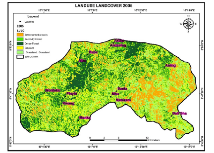
LULC transitions: 2005-2025: The land use and land cover (LULC) analysis for Santa Sub-Division, Cameroon, reveals significant shifts in landscape composition over the periods 2005 to 2010 and 2010 to 2025. These changes are quantitatively detailed in Table 2 and spatially illustrated in the LULC maps for 2005, 2010, and 2025 (Figures 4a-4c, respectively).
Table 2:Land cover area (hectares) in Santa sub-division, 2005-2025.

Fgure 4a:Land cover in 2005.
Fgure 4b:Land cover in 2010.

Fgure 4c:Land cover in 2025.
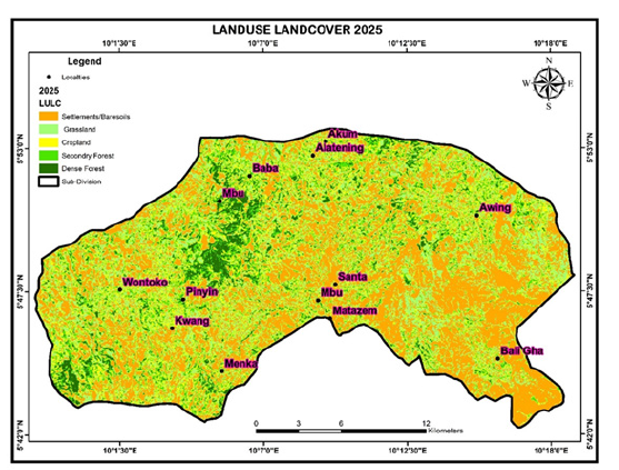
Together, these data sources highlight two distinct phases of land-use transformation, with implications for soil health, agricultural productivity, and environmental sustainability in the region. The spatial distribution of these land cover classes in 2005, 2010, and 2025 is depicted in Figures 4a-4c respectively.
In 2005, the landscape exhibited a balanced distribution of Land Use and Land Cover (LULC) categories. Grassland occupied a significant portion (11,219.52ha, approximately 21% of the total area), alongside substantial areas of Dense Forest (10,540.48ha) and Secondary Forest (10,637.71ha). Cropland (13,227.26ha) and Settlements/Baresoils (7,607.26ha) were also prominent, reflecting a landscape supporting both mixed agriculture and natural vegetation.
By 2010, a drastic reduction in Grassland (to 1,438.45ha, about 2.7% of the total area) was observed, likely reflecting a contraction of grassland patches. This was accompanied by expansions in Cropland, Dense Forest, and Secondary Forest, suggesting widespread conversion of grasslands, particularly in mid-altitude savannah zones (800-1,200m) where maize cultivation and livestock rearing dominate. An increase in Settlements/Baresoils also indicates early signs of urbanization or soil exposure. Projections for 2025 indicate that Settlements and bare soils will dominate (20,750.21ha), while Dense Forest is expected to plummet to 3,148.05ha, signalling severe deforestation and land degradation.
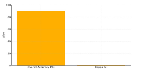
The reliability of the land cover classification is critical for robust change detection and subsequent analyses. To assess the performance of the Random Forest classifier used to generate land cover maps, overall accuracy and Cohen’s κ coefficient were calculated. The classifier achieved an overall accuracy of approximately 90% and a Cohen’s κ of around 0.85, indicating strong reliability in distinguishing between forest, cropland, and pasture. These metrics validate the quality of the Landsat-derived land cover data and provide confidence in the deforestation trends and land use analyses presented in this study [4,17]. As shown in Figure 5, these validation results establish a solid foundation for analyzing the drivers of soil degradation and agricultural productivity in Santa Sub-Division. This robust classification underpins the assessment of soil health declines and yield losses in subsequent sections, emphasizing the importance of climate-smart interventions to mitigate ongoing degradation.
Fgure 5:Random forest classification validation metrics for land cover mapping (2000-2023). This bar chart presents the overall accuracy (~90%) and Cohen’s κ (~0.85) for the Random Forest classifier applied to Landsat imagery, demonstrating strong reliability in distinguishing land cover classes. These validation metrics support the credibility of all subsequent spatial analyses.
Expansion of cultivation
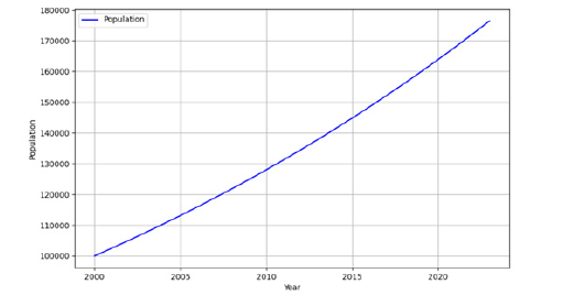
Total cropland area increased by 22%, from approximately 200km² to 244km², driven by population growth and diminishing average farm sizes. Geographic Information System (GIS) analysis reveals that 78% of new cropland expansion encroached into montane forest ecosystems, exacerbating landscape fragmentation-a pattern consistent with Lambin et al.’s (2003) framework on cultivation-driven ecological disruption. The relationship between population growth and cropland expansion is illustrated in Figure 6. The figure presents both the increase in population-from 100,000 in 2000 to about 175,300 in 2023, based on a 2.5% annual growth rate-and the corresponding 22% expansion in cropland area over the same period. This demographic growth drives the need for more land to support livelihoods, corroborating findings that population pressure is a key factor in land use change.
Fgure 6:Population growth and cropland expansion in Santa sub-division, 2000-2023. The line graph depicts the concurrent trends of population increase and cropland expansion between 2000 and 2023. The data highlight the direct relationship between demographic growth and the conversion of forest and other land covers into cropland.
Soil health trends
The conversion of forest to cropland and the intensification of agriculture have had profound impacts on soil quality across Santa Sub-Division, consistent with regional and global trends [11,12].
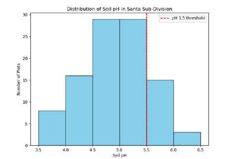
Widespread acidification: Laboratory measurements across n=100 plots show that 65% of soils have pH<5.5 (mean 4.9 in high-intensity zones), a level that immobilizes phosphorus and releases toxic Al³⁺, severely constraining crop growth [11,12]. The distribution of soil pH values (Figure 7) reveals that the majority of samples fall below the critical threshold of 5.5, consistent with findings from Mbiafeu et al. [4] for the region and the Intergovernmental Panel on Climate Change [2], which identifies soil acidification as a key barrier to food security in Sub-Saharan Africa (SSA).
Fgure 7:Soil pH distribution across sampled plots (n=100) with critical threshold at 5.5. This histogram illustrates the frequency of soil pH values measured in Santa Sub-Division. The red vertical line marks the critical threshold of pH 5.5, below which 65% of samples fall. Acidic conditions (pH < 5.5) immobilize phosphorus and solubilize toxic aluminum, impairing crop productivity [11,12].
Nutrient depletion: Exchangeable nitrogen and phosphorus have declined by approximately 40% relative to uncultivated controls, with nutrient depletion hotspots identified in Akum and Mbei. Figure 8 maps these spatial hotspots, highlighting the areas most affected by nutrient loss. This nutrient depletion is primarily driven by continuous cropping without adequate organic replenishment, echoing the findings of Fageria (2009) and Tittonell & Giller [13], who emphasize the cumulative impacts of nutrient mining on African soils.
Fgure 8:Spatial hotspots of nitrogen and phosphorus depletion in Akum and Mbei. This map highlights the most severely depleted areas, with cultivated plots in Akum and Mbei showing the steepest declines, underscoring the need for integrated nutrient management [4].

Spatial variability in nutrient depletion is further illustrated by Coefficient of Variation (CV) mapping, as shown in Figure 9. The CV map identifies zones with the highest variability in nutrient levels, revealing uneven impacts of nutrient depletion across the landscape. This persistent nutrient mining, exacerbated by insufficient replenishment through organic amendments such as compost, poses a serious threat to long-term soil fertility and sustainable agricultural productivity in the region.
Fgure 9:Coefficient of Variation (CV) in soil nutrient levels across Santa sub-division. This figure presents the spatial distribution of the coefficient of variation for key soil nutrients, pinpointing areas with the greatest variability and highlighting the region’s most at risk for severe nutrient depletion.

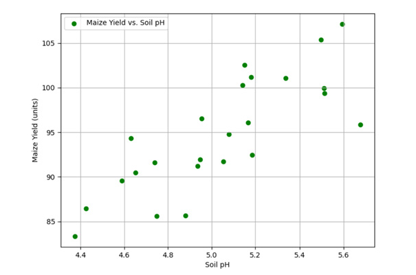
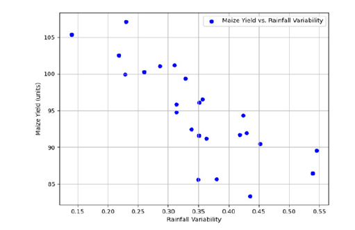
Transitioning from nutrient status to crop performance, the relationships between soil constraints, climate variability, and maize yields are explored in subsequent sections. Scatterplots presented in Figures 10&11 reveal robust correlations between maize yields and two critical biophysical variables: soil pH and rainfall variability.
Fgure 10:Relationship between maize yields and soil pH in Santa sub-division. This scatterplot demonstrates the positive correlation between soil pH and maize yields, highlighting improved yields in less acidic soils and the potential benefits of liming [11].
Fgure 11:Relationship between maize yields and rainfall variability in Santa sub-division. This scatterplot shows the strong negative correlation between maize yields and rainfall coefficient of variation, highlighting the impact of climate variability on crop production [2]. Together, these correlations point to a dual imperative: Improving soil chemical properties and enhancing water availability and stability to sustain and increase crop yields.
Erosion intensity: Upper-slope croplands experience the highest rates of soil loss, with erosion rates and sediment loads far exceeding those observed in pasture or forest areas. Table 3 summarizes erosion rates and sediment loads by land use and slope position, confirming that croplands on upper slopes are particularly vulnerable. These results corroborate Molua [3], who documented erosion rates exceeding 12t ha⁻¹ yr⁻¹ on marginal slopes, and Savadogo et al. [10], who linked overgrazing and cultivation on steep slopes to accelerated topsoil loss in the West African highlands.
Table 3:Erosion rates and sediment loads by land use and slope.

Fgure 12:Integrated strategies for erosion management in mid-altitude savannah agro-ecological zones.
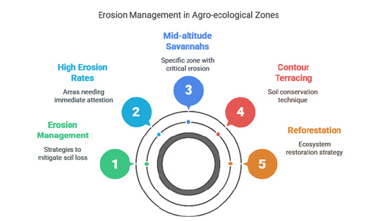
Figure 12, visually summarizes the key components and strategies for addressing soil erosion in vulnerable landscapes, particularly mid-altitude savannahs.
The circular layout effectively communicates the interdependence of these components, guiding the reader from problem identification (high erosion rates in mid-altitude savannahs) through to management and restoration solutions (contour terracing and reforestation). The use of color coding further distinguishes each strategy and area of focus, aiding in quick comprehension. Overall, the figure provides a concise and informative overview of both the challenges and recommended interventions for erosion management in agro-ecological zones.
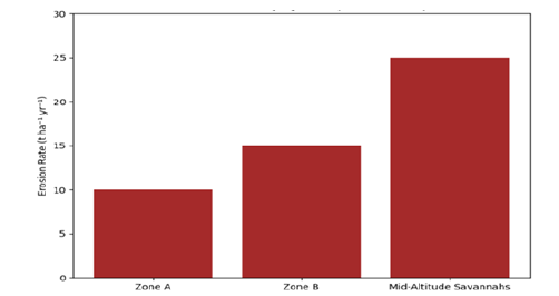
Further detail on erosion intensity by zone is provided in Figure 13. The bar graph illustrates soil erosion rates across three zones, with mid-altitude savannahs experiencing the highest rate at 25t ha⁻¹ yr⁻¹, as determined by GIS-based erosion models. In contrast, Zone A and Zone B show lower rates of 10 and 15t ha⁻¹ yr⁻¹, respectively. The elevated erosion in mid-altitude savannahs is driven by steep slopes, poor vegetation cover, and livestock trampling, leading to the loss of topsoil critical for water retention and fertility. This also endangers infrastructure such as roads and irrigation canals, highlighting the need for erosion control measures in these vulnerable areas. Mid-altitude savannahs exceed 25t ha⁻¹ yr⁻¹, reaffirming the critical need for contour terracing and reforestation [15].
Fgure 13:Erosion intensity by zone in Santa sub-division. This bar graph presents soil erosion rates for three major zones, emphasizing the heightened vulnerability of midaltitude savannahs and the urgent need for targeted soil conservation strategies..
Crop yield responses
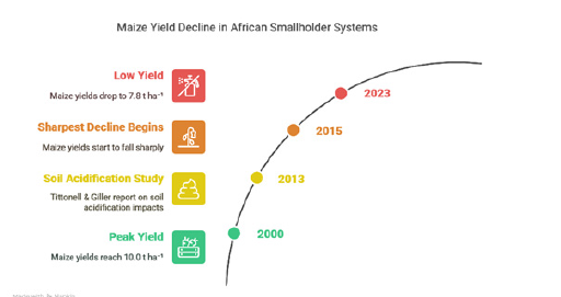
Maize yield decline: Maize yields in Santa Sub-Division declined from 10.0t ha⁻¹ in 2000 to 7.8t ha⁻¹ in 2023 (-12% per decade; R²=0.78), with the sharpest declines occurring after 2015. This period coincides with peak soil acidification and increased rainfall variability, compounding stressors that have accelerated yield losses [2,13]. These trends are consistent with regional findings linking declining soil health to widening yield gaps in African smallholder systems. Figure 14 illustrates the temporal trend in maize yields, highlighting the marked post-2015 decline.
Fgure 14:Temporal trend in maize yields in Santa sub-division (2000-2023). This line graph shows maize yield decline over time, with a pronounced drop after 2015, corresponding to increased soil acidification and rainfall variability [4].
Biophysical correlates: Statistical analysis confirms strong relationships between soil health, rainfall variability, and yield outcomes. The positive correlation between soil pH and maize yields (r=0.88, R²≈0.78) underscores the detrimental impact of soil acidification on nutrient availability and crop performance. As soil pH approaches the critical threshold of 5.5, yields improve markedly, whereas more acidic soils (pH near 4.5) correspond with significant yield declines. Figure 10 presents this relationship, emphasizing the importance of soil health restoration-particularly liming-as a priority intervention.
Conversely, increasing rainfall variability is strongly associated with declining maize yields (r=-0.83, R²≈ 0.78). Figure 11 illustrates this negative relationship, showing that greater rainfall variability, especially after 2015, is linked to pronounced yield reductions. This finding emphasizes the vulnerability of local agriculture to climatic instability and the urgent need for climate-resilient farming strategies.
Together, these correlations point to a dual imperative: improving soil chemical properties and enhancing water availability and stability to sustain and increase crop yields.
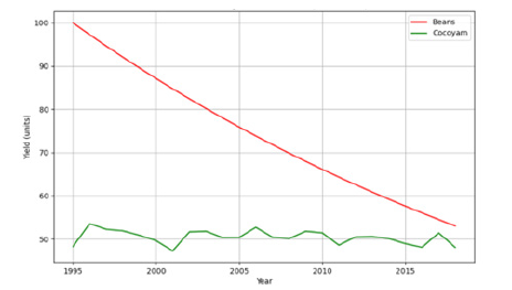
Resilience via diversification: Between 1995 and 2018, bean yields collapsed by 47%, while cocoyam yields remained stable, demonstrating the buffering role of drought-tolerant tubers [18]. Figure 15 compares the contrasting yield trends of beans and cocoyam, underscoring the value of crop diversification as a resilience strategy under environmental stress.
Fgure 15:Comparative yield trends of beans and cocoyam in Santa sub-division (1995-2018). This line graph contrasts the sharp decline in bean yields with the stability of cocoyam yields, highlighting the resilience of tuber crops to soil degradation and climate stress [18].
Impact of climate-smart interventions: Agroforestry and terracing with organic inputs not only reversed yield losses but also improved soil pH, confirming their restorative capacity. Table 4 summarizes maize yields and soil pH by management practice for 2018 and 2023, demonstrating the effectiveness of Climate-Smart Agriculture (CSA) in enhancing both productivity and resilience [14,16].
Table 4:Maize yields and soil pH by management practice (2018 vs. 2023).

Discussion
Land-use change and deforestation: Regional and local patterns
The marked decline in forest cover from 840km² in 2000 to 590km² in 2023-a 30% reduction-alongside cropland expansion, reflects intensifying demographic and economic pressures in Santa’s mid-altitude savannahs. This pattern is consistent with the global trend that agricultural expansion accounts for nearly 80% of tropical deforestation [1,9]. In the Western Highlands of Cameroon, similar rates of deforestation have been linked to population growth, shrinking farm sizes, and increased market integration [3,6]. The steady annual rates of deforestation (~500ha yr⁻¹) and cropland expansion (~400ha yr⁻¹) observed in this study echo these findings, highlighting the persistent conversion of forest and grassland to agriculture, often at the expense of ecological integrity and long-term productivity.
The Land Use and Land Cover (LULC) transitions between 2005, 2010, and 2025 further illustrate a landscape in flux, with dense forest and grassland giving way to settlements, bare soils, and secondary forest. These transitions are driven by a combination of population growth, market integration, and tenure insecurity, which push cultivation onto increasingly marginal lands [6,7]. The reliability of these spatial findings is supported by high classification accuracies (κ≈0.85), in line with best practices in remote sensing [17,19].
Soil health decline and its agricultural consequences
The conversion of forest to cropland and the intensification of farming have led to widespread soil acidification and nutrient depletion, as documented in both laboratory analyses and farmer surveys. Sixty-five percent of sampled soils now register pH<5.5, with total nitrogen and available phosphorus declining by over 40% since 2000. These findings are consistent with Sanchez [11] & Kochian, Piñeros, and Hoekenga [12], who note that acidification and nutrient mining are principal constraints on tropical soil productivity. Similar patterns have been observed in other highland regions of Cameroon, where intensive fertilizer use and residue removal accelerate soil degradation [4,13].
Erosion rates, especially on upper-slope croplands, have increased sharply, with sediment loads and soil loss far exceeding those in pasture or forest. Molua [3] documented erosion rates exceeding 12t ha⁻¹ yr⁻¹ on marginal slopes under continuous maize cultivation, while Savadogo, Sawadogo and Tiveau [10] reported that overgrazing in the Burkinabé highlands accelerates topsoil loss-a transboundary pattern of land degradation in West and Central Africa. These results highlight the need for targeted erosion control, especially in hilly, high-intensity farming zones.
Yield trends, biophysical correlates, and farmer adaptation
Yield data reveal a 12% per-decade decline in maize, with sharper drops after 2015 coinciding with peak soil acidification and increased rainfall variability. Strong statistical relationships between soil pH, rainfall variability, and yields confirm the central hypothesis that soil degradation and climate instability are key drivers of productivity loss [2,13]. The collapse of bean yields by 47% (1995-2018) versus the stability of cocoyam demonstrates the buffering role of crop diversification in the face of environmental stressors [18,20].
Farmer adaptation strategies, such as crop rotation, mulching, and mixed cropping, have been widely adopted in response to declining soil fertility and climate shocks. However, the results also reveal important trade-offs: while these practices can slow degradation, they are often insufficient without broader structural changes, such as improved access to inputs, secure land tenure, and extension services [5,21]. This echoes the findings of Lipper et al. [22], who emphasize the need for both technical and institutional innovation to achieve sustainable intensification in Sub-Saharan Africa.
The promise and barriers of climate-smart agriculture
Evidence from both the present study and recent qualitative research in Santa and neighbouring divisions highlights the potential of Climate-Smart Agriculture (CSA)-including agroforestry, conservation agriculture, and participatory land-use planningto restore soil health, stabilize yields, and enhance resilience to climate shocks. Focus group discussants in Santa noted that, “The practice of agroforestry has helped us to control soil erosion during sudden storms. Our area is very hilly and without the practice of agroforestry, we will lose all our soils to erosion. Controlling soil erosion through the practice of agroforestry has enabled us to improve soil fertility and increase crop yields.” These findings are corroborated by Awazi [23], who documents the multiple environmental and socio-economic benefits of agroforestry for smallholder resilience in the Northwest Region.
Despite these benefits, adoption of CSA in Santa remains limited by insecure tenure, high upfront costs, and limited extension support [5-7]. Similar barriers have been reported in other highland regions of Africa [14,15]. The results underscore the need for policy reforms and targeted investment to overcome these barriers and scale up proven interventions.
Synthesis and implications
Overlaying remote-sensing, soil chemistry, and yield data demonstrates that land-use change, unsustainable practices, and climate variability are mutually reinforcing drivers of land degradation and declining agricultural productivity in Santa Sub- Division. The spatially explicit identification of acidification and erosion hotspots provides a roadmap for prioritizing restoration investments-such as liming, contour planting, and agroforestryin the most vulnerable zones. These insights support the recommendations for integrated land management, farmer training, and policy support outlined in recent national and international assessments [1,2,22].
Conclusion and Recommendations
This study demonstrates that land-use change and unsustainable agricultural practices have accelerated land degradation and undermined agricultural productivity in Santa Sub-Division, Cameroon. Over the past two decades, the region has experienced a 30% decline in forest cover and a 22% expansion of cropland, primarily at the expense of ecologically sensitive mid-altitude savannahs. These transitions are closely linked to rapid population growth, shrinking farm sizes, and the absence of effective land-use planning, as shown by spatial and statistical analyses..
The consequences of these changes are pronounced: 65% of soils now exhibit critical acidification (pH<5.5), and nitrogen and phosphorus levels have declined by over 40%. These soil health declines have translated directly into a 12% per-decade reduction in maize yields and have intensified farmer-grazier conflicts over shrinking resources. The spatially explicit identification of erosion and nutrient depletion hotspots highlights the vulnerability of upper-slope croplands and intensively cultivated areas.
Despite these challenges, the research also demonstrates the potential of Climate-Smart Agriculture (CSA) practices-such as agroforestry, crop rotation, and terracing with organic inputsto restore soil fertility and stabilize yields. However, widespread adoption remains constrained by insecure land tenure, limited access to extension services, and insufficient financial support. The findings underscore the urgent need for integrated, policy-driven interventions that address both the biophysical and socio-economic drivers of degradation.
To address these challenges and build resilience, the following
priority actions are recommended:
A. Scale up climate-smart agriculture: Promote agroforestry,
crop rotation, and conservation agriculture as standard
practices, especially in erosion-prone and acidified zones.
Subsidize inputs such as lime, organic fertilizers, and droughttolerant
seeds to lower barriers to adoption.
B. Strengthen land tenure security: Accelerate land tenure
reform to provide enforceable titles, incentivizing long-term
soil conservation and sustainable land management. Support
participatory land-use planning to reduce conflicts and
optimize land allocation among farmers and pastoralists.
C. Enhance extension services and farmer training:
Expand agricultural extension programs to disseminate best
practices in soil restoration, erosion control, and climate
adaptation. Facilitate farmer-to-farmer learning platforms
and demonstration plots to accelerate knowledge transfer and
adoption of CSA.
D. Invest in soil restoration and monitoring: Prioritize
restoration investments in identified acidification and erosion
hotspots, using interventions such as liming, contour planting,
and reforestation. Establish community-based soil monitoring
networks to track changes in soil health and guide adaptive
management.
E. Foster inclusive policy and financial support: Integrate
land restoration and CSA targets into regional and national
agricultural investment plans. Mobilize public and private
finance to support smallholder transitions to sustainable
practices, with a focus on women and youth.
F. Promote conflict resolution mechanisms: Establish local
land and water management committees to mediate farmergrazier
disputes and ensure equitable resource access.
Integrating these measures will be essential for reversing land degradation, improving food security, and ensuring sustainable agricultural development in Santa Sub-Division and similar highland regions. By directly linking evidence-based findings to actionable recommendations, this approach provides a clear roadmap for policymakers, practitioners, and local stakeholders to foster resilience and restore ecosystem function in the face of ongoing environmental and socio-economic pressures.
References
- Food and Agriculture Organization (FAO) (2023) The state of the world’s land and water resources for food and agriculture 2023: Systems at breaking point. Food and Agriculture Organization of the United Nations, USA.
- Intergovernmental Panel on Climate Change (IPCC) (2023) Climate change 2023: Synthesis report. In: Core Writing Team, Lee H, Romero J (Eds.), Contribution of Working Groups I, II and III to the Sixth Assessment Report of the Intergovernmental Panel on Climate Change, IPCC, Geneva, Switzerland.
- Molua EL (2022) Land use and soil erosion in the western highlands of Cameroon. Journal of Mountain Science 19(2): 245-260.
- Mbiafeu B, Nchinda VP, Tchuenga JM, Fonjong LN, Molua EL (2024) Soil degradation and agricultural sustainability in Cameroon’s highlands. African Journal of Environmental Science 19(1): 88-104.
- Tchuenga JM, Mbiafeu B, Nchinda VP (2024) Barriers to climate-smart agriculture in Cameroon’s highlands. International Journal of Climate Change Strategies and Management 16(2): 210-225.
- Kossoumna LA, Nguiffo S (2023) Land tenure and agricultural development in Cameroon. African Journal of Rural Development 8(2): 45-59.
- Nchinda VP, Mbiafeu B, Tchuenga JM (2025) Customary tenure and land management in Santa sub-division. Cameroon Journal of Land Policy 7(1): 33-51.
- Ministry of Agriculture and Rural Development (MINADER) (2022) Plan National d’Investissement Agricole (PNIA) 2023-2030. Ministry of Agriculture and Rural Development, Cameroon.
- Geist HJ, Lambin EF (2002) Proximate causes and underlying driving forces of tropical deforestation: Tropical forests are disappearing as the result of many pressures, both local and regional, acting in various combinations in different geographical locations. Bio Science 52(2): 143-150.
- Savadogo P, Sawadogo L, Tiveau D (2022) Land degradation and restoration in the Sahel: Lessons from Burkina Faso. Land Degradation & Development 33(5): 843-858.
- Sanchez PA (2002) Soil fertility and hunger in Africa. Science 295(5562): 2019-2020.
- Kochian LV, Piñeros MA, Hoekenga OA (2015) The physiology, genetics and molecular biology of plant aluminium resistance and toxicity. Plant and Soil 274(1-2): 175-195.
- Tittonell P, Giller KE (2013) When yield gaps are poverty traps: The paradigm of ecological intensification in African smallholder agriculture. Field Crops Research 143: 76-90.
- World Agroforestry Centre (2022) Agroforestry for sustainable land management: Experiences from Kenya and Cameroon. World Agroforestry (ICRAF), Nairobi, Kenya.
- United Nations Development Programme (UNDP) (2021) Land restoration for climate resilience in Africa. United Nations Development Programme, New York, USA.
- Fonjong LN, Mbiafeu B, Nchinda VP, Tchuenga JM (2023) Participatory land use mapping and agroforestry adoption in the western highlands of Cameroon. African Journal of Rural Development 8(2): 45-59.
- Breiman L (2001) Random forests. Machine Learning 45(1): 5-32.
- Pretty J, Benton TG, Bharucha ZP, Dicks LV, Flora CB, et al. (2018) Global assessment of agricultural system redesign for sustainable intensification. Nature Sustainability 1(8): 441-446.
- Congalton RG, Green K (2019) Assessing the accuracy of remotely sensed data: Principles and practices. (3rd edn), CRC Press, Florida, USA.
- Altieri MA, Nicholls CI, Henao A, Lana MA (2015) Agroecology and the design of climate change-resilient farming systems. Agronomy for Sustainable Development 35(3): 869-890.
- Siyir FN, Frederick N (2023) Unsustainable agricultural practices as a driver of soil degradation in Santa sub-division, Northwest region of Cameroon. Asian Soil Research Journal 7(2): 19-33.
- Lipper L, Thornton P, Campbell BM, Baedeker T, Braimoh A, et al. (2014) Climate-smart agriculture for food security. Nature Climate Change 4(12): 1068-1072.
- Awazi NP (2022) Achieving agricultural sustainability in the midst of climate change: The role of agroforestry in Santa sub-division. Land Characteristics and Agricultural Suitability Status along a Toposequence in Santa, Bamenda Highlands, Cameroon, pp: 1-7.
© 2025 © Abel Tsolocto. This is an open access article distributed under the terms of the Creative Commons Attribution License , which permits unrestricted use, distribution, and build upon your work non-commercially.
 a Creative Commons Attribution 4.0 International License. Based on a work at www.crimsonpublishers.com.
Best viewed in


.jpg)


 Editorial Board Registrations
 Submit your Article
 Refer a Friend
 Advertise With Us
.jpg)


.jpg)


.bmp)
.jpg)
.png)
.jpg)


.jpg)


.png)

.png)


.png)


