- Submissions

Full Text
Environmental Analysis & Ecology Studies
Evaluating Community Perception of Forest Conservation Policies and Impact on Land Cover Change Towards Sustainable Management of Mount Cameroon National Park
Usongo A Patience*
Department of Geography, University of Buea, Cameroon
*Corresponding author:Usongo A Patience, Department of Geography, University of Buea, Cameroon
Submission: March 18, 2024; Published: April 25, 2024

ISSN 2578-0336 Volume12 Issue1
Abstract
Forest conservation policies have been used to recognize the important role Forest Adjacent Communities (FAC) play in the conservation of forest resources. Evaluating the effectiveness of these policies around the Mount Cameroon National Park is paramount for sustainable forest management in the area. The study examined community perception of forest conservation policies and impact on land cover change. Primary data were obtained from the field with the use of a Global Positioning System (GPS), household surveys, questionnaires, key informants and focus group discussions. Secondary data were obtained from journals, textbooks, libraries and internet. Landsat imageries for the years 2003, 2010 and 2021 were downloaded from Global Land Cover Facility (GLCF) website. Remote Sensing and Geographic Information System (GIS) techniques were used in the analysis of satellite imageries between 2003 and 2021.The study revealed a significantly negative perception of forest conservation policies resulting to a high rate of deforestation in the area. Forest coverage showed a steady increase from 2003 to 2010 and a decrease in the year 2021. The total surface area occupied by the dense forest was 10,841.7ha, 33,432.6ha and, 32,409ha (90.9%) respectively for 2003, 2010 and 2021 representing a total forest loss of 1,023.6ha and an annual loss of 102.36ha. Degraded forest showed a progressive increase over the years. To better enhance forest conservation polices for sustainable resource management, alternative income generating activities should be provided alongside education and sensitization programs to create awareness on the need for forest conservation.
Introduction
Worldwide, anthropogenic activities have been on the increase since the dawn of the industrial revolution due to population increase and advancements in technology. This phenomenon has resulted to the encroachment of human activities into wilderness areas such as protected areas. According to the International Union for Conservation of Nature (IUCN), a Protected Area (PA) is a clearly defined geographical space, recognized, dedicated and managed, with the use of effective means, to achieve long-term conservation of nature with associated ecosystem services and cultural values [1]. The prime goal of protected areas is to effectively protect, develop and maintain representative samples of the various biological species in the areas where they are found [2]. The creation and installation of PAs have been a central focus in the conservation of species since the beginning of the 19th century.
Although PAs have usually been set aside from human exploitation, it is now increasingly recognized that they can better play a role in sustaining the livelihood of adjacent local communities [3]. Communities in and around protected areas feel their subsistence opportunities are threatened and thereby develop a hostile attitude toward conservation strategies [4,5]. For instance, in Bwindi Impenetrable Forest, Uganda, after the national park was gazetted, several fires were deliberately set, burning 5% of the forest [6]. In Tsitsikamma National Park, South Africa, local communities practice illegal activities as a form of retaliation to command-and-control conservation policies [7]. Direct human activities within PAs, such as harvesting of wild plants and animals, logging, agriculture and livestock herding, increases when an inadequate park design and administrative structures disregards the needs of local populations to sustain their livelihoods [8]. Local communities’ perceptions of protected areas influence their activities and as well affect conservation effectiveness [9,10]. Therefore, understanding the perceptions of indigenous people about conservation is vital in the management and effective functioning of PAs [11].
Cameroon is a country endowed with abundant forests located between latitudes 2º and 5º north of the equator, and occupying about 70% of the country’s land area. Cameroon has an estimated 22 million hectares of forest resources with the forest sector contributing more than 3% of the Gross Domestic Product (GDP) and accounting for 7% of total export. Cameroon’s forest is a vital resource to the Central African region given that it fulfills critical environmental, economic, social and cultural functions in the region [12,13]. Overtime, Cameroon has however been losing its forests because of deforestation. The alarming rate of deforestation of 100,000 hectares per year is attributed to human activities such as lumbering, shifting cultivation, fuel wood and construction. These activities not only threaten livelihood security of most people dependent on forest ecosystem services but also have significant impact on the accumulation of greenhouse gases in the atmosphere [14]. As a result of the negative consequences of the forest loss to the environment, Cameroon is a signatory to several international cooperation agreements and conventions including; the Ramsar Convention on Wetlands of 1971, the World Commission on Environment and Development of 1987 in Oslo 1987, and the United Nations Conference on Environment and Development (UNCED) of Rio de Janeiro in 1992 to help preserve biodiversity. They also exist national and local laws to help preserve nature. Community participation is highly recognized as an effective strategy in the conservation of forest resources [15].
The rapid growth of African cities such as Buea in Cameroon has led to intense intrusion of human activities in PAs in search of resources to satisfy human needs and wants. Given that, humans need resources to survive, invading PAs by disregarding laws and policies remains a serious problem to conservation actions nowadays. This is evident through increased rates of deforestation and poaching operations in forest reserves for fuel, food, clothing and construction among other uses [16,17]. To better manage protected areas, conservation policies have been put in place. Protected area management often includes strict regulations that exclude local people from areas that they may have previously used to gather resources such as fuel wood, materials for shelter and farming, fodder and Non-Timber Forest Products (NTFPS) [18]. In some cases, indigenes are removed from their lands and left with very little or no alternative livelihood sources or adequate compensation) [4,5]. In this regard, the management of PAs often conflict with the economic interest of local people [19] of which, without local support, the long-term existence of PAs is not assured [20]. Local people will rarely support the conservation of PAs if they have negative perceptions and attitudes toward them [18]. Community’s attitudes toward protected areas conservation may be influenced by staff or management interventions, local economic needs and history, or other indirectly related factors such as government policy. According to [21], local people’s perceptions are related to costs and benefits produced by PAs, their dependence on its resources, and their knowledge about PAs.
Forest conservation policies have in the past largely failed to recognize the important role Adjacent Forest Communities (FAC) can play in the conservation of forest resources. Within the Mount Cameroon National Park (MCNP), efforts to incorporate local communities in conservation policies have not adequately recognized the variable nature of adjacent forest communities which could result in conflicts over the use and conservation of forest resources. Forest lands in the area are threatened by agriculture, commerce, settlement, transport network and other major development projects. Fuel wood collection by the communities’ dwellers have also significantly contributed to deforestation. Lack of involvement of the Forest-Adjacent Community (FAC) through consultations in the policy formulation processes can exacerbate more of these threats since the community does not consider itself as part of the management team. This has given a clear indication that without local support, implementation of these state-based forest conservation initiatives, regulations and policies, is deemed to fail. Equally, inadequate compensation or failure to take into accounts the needs of local people who are dependent on forest resources in the Park has compelled many local people to go against Park rules especially through intense resource harvesting. Hence, biodiversity conservation is plagued with challenges. Understanding the discrepancies between the intentions of national policies and realities on the ground becomes imperative in this era of intensive degradation of forest resources. The focus of this paper is to examine community perception of forest conservation policies and impacts on land use/land cover change within the Mount Cameroon National Park to enable putting in place appropriate policies for effective forest management.
Material and Methods
Study area
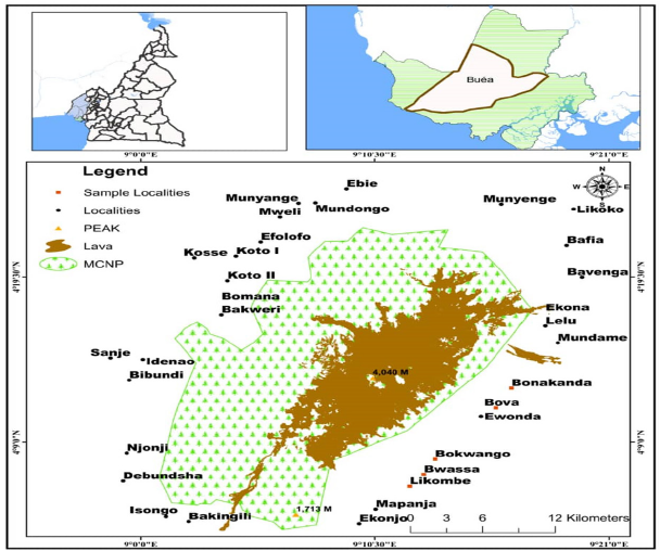
Mount Cameroon National Park lies on the coast, in the Gulf of Guinea, between 3°57’- 4°27’ N and 8°58’-9°24’E (Figure 1). It is a huge volcanic mass with its long axis (about 45km long and 30km wide) running SW to NE. The main peak is at 4°7’N, 9°10’E at altitude 4,100m. It is an active volcano, which erupts almost every two decades. It covers a total surface area of 58,178ha and is located within four sub-divisions: Buea, Muyuka, Mbonge and Idenau. The MCNP is made up of 41 villages bordering it directly. There are cosmopolitan centers almost around the park: Limbe; Mutengene, Buea, Ekona, Muyuka, Munyenge and other petty villages.
Figure 1:Map of Buea Municipality showing the Mount Cameroon National Park.
The area has two distinct seasons, the wet season (between June and October) and dry seasons (between November and May) and characterized by extreme rainfall and elevated temperatures. Mean annual temperatures decrease from 26 to 29 °C at sea level to 0 °C at the top of the mountain. The highest rainfall occurs on the southwestern flank where it can reach 10-12m/year at Debundcha [22]. Temperature varies from an average of 25.5 to 27 °C at the foot of the mountain to about 32 to 35 °C during the hottest months (March and April). Mount Cameroon contains high species diversity and endemism in its flora and fauna. It has at least 2,300 species of plants in more than 800 genera and 210 families have been recorded. Out of these, 49 species are strictly endemic and 50 near endemic plant species. The region is also very diverse in fauna with over 370 species recorded. So far, 210 species of birds have been record out of which 8 are threatened and 2 strictly endemic [23]. The diversity of plant and animal species has earn the region an internationally recognized status as a biodiversity ‘hot spot’ in Cameroon [24]. The area has rich volcanic soils of recent origin [25]. The rich volcanic soils in the area explain the presence of the Agro-Industrial company. The Cameroon Development Corporation (CDC) in the area.
The population is estimated at about 300,000 people and twothirds live in urban and Semi-urban areas, while the rest live in villages. In all the villages, the population is expanding from both natural increase and Immigration. These people are predominantly farmers, hunters, pit sawyers, fishermen and traders [26] along the Atlantic coast. They depend either directly or indirectly on the resources of the MCNP and its peripheries. However, favorable climate, high soil fertility of the area and the presence of Agroplantations are major reasons for the increasing immigration.
Research Design and Sampling Techniques
The study adopted a mixed research design, collecting data from different perspectives. The study acquired both qualitative and quantitative data that describe community perception and how they are been influence by the conservation policies put in place.
A multi-stage random sampling design with a three-stage sampling process consisting of purposive stratified and systematic random sampling procedures were used for the study. The first stage was the selection of the protected area. A purposive sampling design was used in the selection of the Mount Cameroon National park for the study. The second stage was the selection of the sampled villages. It involved villages around the park, to enable a better appreciation of the situation within the Park. The factors guiding the choice of the villages were Proximity, Accessibility and Security (PAS). A stratified random sampling design was used in selecting the villages with stratification based on their proximity to the Park. Villages in close proximity (>10km) were chosen because their direct interactions with the forest were more evident than villages that are far away (<10km). Various studies carried out by 24. MINEF [24] indicate that the greatest impact on forests is exerted by forest-adjacent communities living within a range of 5km from the forest borders [27] further assert that this impact decreases with distance from the forest border. They further contend that beyond the 10-km radius, the impact is less significant. It was therefore hypothesized that the people living within the 10-km radius from the forest boundary have the highest dependency level on the forest and therefore a high impact on the forest resource. Such communities would therefore be important when formulating integrated strategies for sustainable forest management and were therefore the focus of the study. The third stage involved the selection of the sampled population for perception studies. A systematic random sampling design was used in selecting the households for interviews and questionnaires administration. Systematic sampling involved selecting a sample unit at random, then selecting every nth unit systematically. The nth unit varied depending on the number of households in the villages. In large communities, a step of 5 houses was chosen while in small communities there was a step of 3 houses. A total of four villages were selected for the study
A stratified random sampling technique was used in collecting the training data to be used for the supervised classification. Maps of unsupervised classification were used in the field to identify key land cover/ land use classes. Sample points were distributed proportionally according to the area of each land cover class. However, some adjustments were made where it was not possible to access some randomly selected points. Oral interviews with residents on land cover and land use changes within their area provided ample evidence to further assign the training points [28]. The study used appropriate satellite images with multispectral bands that allows for a multi dates applications.
Data Collection
Relevant data for the study were collected from both primary and secondary sources. Primary data collection for perception analysis were dependent upon household surveys, administration of questionnaires, key informants as well as focus group discussions. A total of 200 questionnaires were distributed in the various villages. The unit of response (respondent) was a household member of 15 years and above. Primary data also covered the opinions of traditional council members, village elders, youths and women gathered through questionnaires and semi-structured interviews. The opinions of management staff, government officials, legal experts, forces of law and order, members of NGOs were elicited through semi-structured interviews and focus group discussions. Primary data for land cover change was obtained from Ground Control Points (GCPs) collected from the various land cover and land use types identified using a hand held Global Positioning System (GPS).
Secondary data were obtained from both published and unpublished documents on forest conservation within parks or national parks. Documents like text books, journals, articles among others were equally made use of. Land Sat satellite imageries for the year 2000, 2010 and 2020 for LULCC analysis were downloaded from the Global Land Cover Facility (GLCF) website
Perception analysis
To investigate community perception of forest conservation policies and its implication for sustainable forest management, qualitative data collected through various sources were analyzed. Questionnaires were analyzed using the SPSS Statistical Package for Social Scientists (SPSS). Descriptive statistics such as frequencies, tables, percentages, cross tabulations, bar and pie charts were used. Relevant inferential statistical methods such as the chi square contingency analysis was used to link some socio demographic characteristics and aspects of policies and laws within protected areas. The data collected from the archives the forest departments in Buea were buttressed with data generated through focus group discussions and interviews to analyze the impact of forest policies enforcement on the perception of communities within protected areas.
Determination of land use land cover change
To evaluate the changes in forest cover relative to other land uses, Geographic Information System (GIS) and Remote Sensing techniques were used in the analysis of satellite imageries between 2003 and 2021. The activities that were carried out include; satellite image processing and classification for LULCC detection. The landsat imageries were geo-referenced to the coordinate system of the study area (WGS84, projection: UTM zone 32). Erdas Imagine 9.2 software was used in processing and analyzing the imageries. Visual interpretation of satellite imageries was enhanced through the use of linear stretching. Clouds and cloud shadows present on images used for the study were reduced through masking techniques in Erdas Imagine Software.
Two main steps were followed in LULCC mapping. First unsupervised image classification was carried out prior to field visits, in order to determine strata for ground truthing. Supervised classification based on Maximum Likelihood Classifier algorithm was then used in the classification of the 2003, 2010 and 2021 images. This was based on ground control points collected. Expert knowledge was used in selecting the points. The sample points collected were used for validating classification results.
Assessment of the rate of land cover change
To access the effectiveness of forest conservation policies in maintaining forest land cover, an estimate of the rate of change for the different land covers was computed based on the following formula [29]:


Effectiveness of forest conservation policies
The study adapted the Management Effectiveness Tracking Tool (METT) method by IUCN designed to track and monitor progress towards protected area management effectiveness. The methodology used is a rapid assessment based on a scorecard questionnaire. The scorecard includes all six elements of management identified in the IUCN-WCPA Framework but has an emphasis on context, planning, inputs and processes. The effective management of protected areas will depend on many factors: political will to fund and manage the protected area; the resources (human, financial) to address the threats to its integrity; and the attitudes and the acceptance of the protected area by local and indigenous communities, may all contribute to the success of protected areas in meeting their ecological and social objectives [30].
In this study, deforestation was used as a surrogate for comparing effectiveness of forest policies, with less deforestation equating to stronger effective application of forest policies. The respondents’ perception and results of LULCC analysis were used to evaluate the effectiveness of forest conservation policies in the area. If the LULCC change is either decreasing or increasing it is a pointer to human activities. The presence of human activities implies the policies are not effective while the absence of such activities is proof of effectiveness of the policies.
Results and Discussion
Socio demographic characteristics of respondents
The socio demographic characteristics of respondents analyzed in this study include: gender, level of education, age, marital status, and household. The information was deemed necessary in that, it plays an important role in influencing respondents’ perception of forest conservation policies which affect their behaviors and attitudes towards the national park and the entire mountain forest area. The summarized results are presented on Table 1.
Table 1:Profile of Respondents.
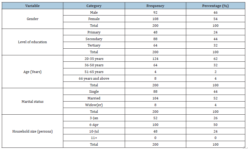
The survey sample consisted of 200 respondents. By gender, 46% were males while 54% were females. A majority of the respondents (62%) were between the age group of 20-35 years, followed by the class of 36-50 years with 32% while people older than 50 years were 6% of the sampled population. With regards to the educational levels of the respondents, 24% had attained primary education, 44% had secondary education and 32% had attained tertiary education. By this, the least educational qualification of respondents was First School Leaving Certificate indicating some degree of literacy of the population. Also, the results of the analysis revealed that, a greater majority of the respondents (52%) were married while those who were single constituted 44% and widow(er) were 4% of the population. Of the sampled respondents, 26% had household sizes of less than 4 persons, 50% had 4-6 persons and the 24% were those with households of 7 and more persons.
Respondents’ perception of forest conservation and definition of a forest /national park
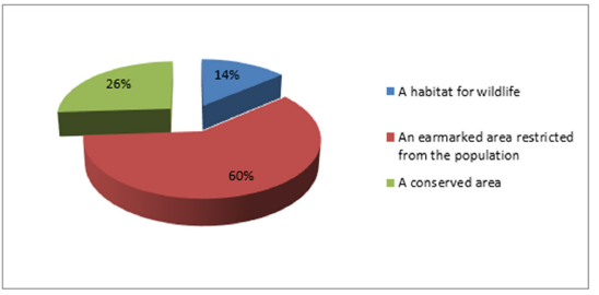
Based on field investigation, the respondents were very much aware of forest conservation and the existence of the Mount Cameroon National Park as a protected area. By this, all the respondents acknowledged that, there is a protected area within the Mount Cameroon Forest, known as the Mount Cameroon National Park, owned by the state. The study assessed the views of the respondents regarding their understanding of a forest/national park. By this, respondents expressed diverse opinions of which the most expressed are presented in Figure 2.
Figure 2:Respondents’ understanding of a forest national par.
Respondents’ views on reasons for State’s ownership of MCNP
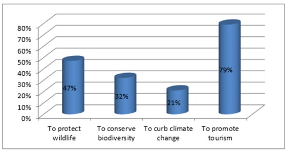
With regards to the ownership of the MCNP, all respondents acknowledged it is a state-owned property. They expressed diverse views with regards State’s ownership. A total of 47% said it is to protect wildlife, 12% were of the opinion that it is to conserve biodiversity, 21% said it is to curb climate change and 29% were of the view that it is to promote tourism (Figure 3).
Figure 3:Respondents’ views on the reasons for State’s ownership of MCNP.
Activities permitted/carried out within the MCNP
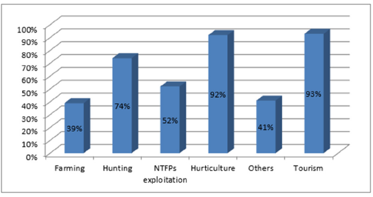
The study investigated if there were any activities permitted by the state to be practiced by the population in supporting their livelihoods within the MCNP. Results revealed that NTFPs exploitation and tourism were the only two activities allowed by the government to take place within the Park. However, a number of other activities were noticed to be practiced in and around the MCNP as highlighted by the respondents. As such, the actors who operate the said activities were forest guards and some people from adjacent forest communities as shown on Figure 4. From Figure 4, horticulture and tourism were revealed to be the most dominant activities in the area as acknowledged by 92% and 93% of the respondents respectively. Farming was the least with 39% of the population engaged. Hunting was said to be practiced by 74% of the respondents and NTFPs exploitation by 52% of the respondents Also, the activities are operated by either inhabitants of the forest based communities or conservation personnel like forest guards among others.
Figure 4:Activities practiced within and around MCNP
Perception on changes within the MCNP
The study also investigated the perception of respondents regarding changes observed within the MCNP over the years. They were asked if the park has changed in terms of forest coverage, and 58% acknowledged an increasing rate while 42% observed a decreasing rate over the years.
Community Awareness and Appraisal of Forest Conservation Laws and Policies
Knowledge of Laws
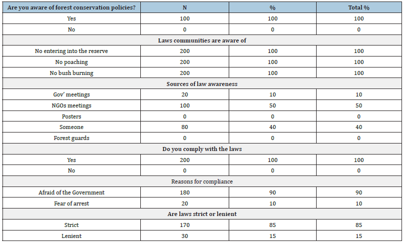
The respondents were asked whether they were aware of forest conservation laws, and they all answered in the affirmative. To ascertain this response, they were asked to list the regulations they knew. Three major laws that emanated from the listing were: no entry into the reserve to carry out any activity, no poaching and no bush burning (Table 2). This was a clear reflection of the peoples’ needs from the forest and also information received through community sensitization exercises from forest management organizations. They tended to know more of the regulations in relation to what the forest is used for in their communities and what they have been told by forest management organizations. During the focus group discussions community members said that if they want to enter the reserve for NTFPs collection, wood exploitation to be used for construction they have to obtain valid permits from the Delegate for Environment and forestry.
Table 2:Community awareness and appraisal of forest conservation laws and policies.
Sources of law awareness
After identifying the laws, they are aware of, the respondents were asked to state their sources of information. A similar trend as per source was observed in Korup and Bakossi. Generally, 50% of the people were educated on forest conservation policies by NGOs, 10% through government meetings, 40% from someone. This shows the importance of NGOs in educating and sensitizing the communities on forest policies in the area. This is a commendable effort by NGOs in the area of sensitization targeted at ensuring the conservation of resources within protected areas. This however confirms the fact that NGOs as non-state actors have been found to be associated with governance within protected areas [31,32].
Compliance with laws and regulations
After establishing what the community knew about forest rules, they were asked whether they observed these rules in their endeavors to acquire any forest products. A total of 78% of the sampled population expressed the view that they respect the laws/policies that have been put in place and 22% stated the laws are not being respected. The impression created here is that the people observe the rules religiously. However, this impression was dismissed during group discussions, the reason being that in group discussions, the group members talked to represent the community and hence there was no fear of exposure whereas from personal interviews, respondents were afraid to expose themselves for not obeying laid down regulations. A key informant from the Delegation of Environment and Forestry also confirmed that very few people come for permits in order to collect forest products. Most people simply sneaked into the forest to collect what they want. Findings revealed that inhabitants of Gwasa and Bokwago embank on poaching and cutting down of trees and these actions are inevitable because they consider themselves as forest dependents communities This finding is in line with the views of; [33] who stated that most communities in developing countries always resist these policies because of their dependency on forest products for their livelihoods.
The respondents were asked to give reasons for compliance. Two pertinent issues arose from the interviews on this issue. Firstly, there was the fear of the Government officials such as the forest guards and the forces of law and order such as the police and gendarmes as indicated by 90% of the sampled population. This is an indication that the government plays a great role in the enforcement of forest conservation policies in the area. Secondly, there is the fear of arrests as indicated by 10% of the respondents if caught without a permit or collecting products that have been banned by law. They would therefore go for the permit in order to secure freedom to be in the forest. From group discussions, it was found that the community members were not comfortable with the issue of permits. They complained of the bottle necks involved in the process.
The respondents were also asked to appraise the laws that had been put in place. The general opinion was that forest policies put in place are strict as indicated by 85% of the sampled population and only 15% of the population said it is lenient as seen on Table 2. During group discussions the people cited some incidents to portray the strict nature of the laws. The people complained that before the creation of the MCNP they could enter and collect forest products without harassment, which is not the case today. Community members also cited some incidents of arrests of some members. These incidents have significantly affected the perception and attitude of the people toward the forest reserve.
Furthermore, 15% of the respondents claimed that the laws were lenient because there were compensated for their loss through the provision of alternative sources of income to stop them from entering into the reserve such as: animal rearing, poultry farming and the collection of some NTFPs such as bush mango.
Risks involved in practicing unauthorized activities in the MCNP
The study assessed the perception of the population on the risks involved in carrying out activities which are considered illegal by the state’s governing body of the MCNP. By this, 92% of the respondents attested of risks involved in carrying out unauthorized activities within the Park as shown on Figure 5. Based on the findings, 82% of the respondents identified that paying fines was the risk with the highest proportion followed by attacks from animals like elephants, snakes, bees among others as attested by 67% of respondents, serving a jail term was identified by 43% of the respondents.
Test of hypothesis on the socio-demographic characteristics of the population and aspects of policies and laws within MCNP
A chi square test of independence was used to determine if the perception of some aspects of laws forest policies vary with the socio-demographic characteristics of respondents. The sociodemographic parameters used for the analyses were; gender, age and educational. Table 3: presents the chi square result, DF and significance of the Chi-square test between forest policies and demographic characteristics. Results of the chi square analysis shows that there exist no relationship between the age and sex of respondents and the level of educational attainment. The level of education of community members has a highly significant impact on law compliance, risk of entering into the reserve and opinions about laws within protected areas. Though other factors like awareness through sensitization and fear of arrest can influence compliance with the law, education is an important factor in the area that can influence compliance with the law and risks of entering into the reserve. The more educated a community is the more will be their level of awareness and compliance with the laws of parks conservation. This is similar to finding of Vitousek, et al. [34] who revealed that; educational level influence perception of forest conservation policies.
Table 3:Chi-square test result. NS= Not Significant, HS= Highly Significant, Df= Degree of freedom

Results further revealed a significant relationship between law awareness and risk of entering into the Park. This is because the communities are aware of the laws and the associated risks of entering into the Park. The more they are aware of the laws, the more they know of the risks. The nature of law enforcement is highly significant with law compliance and land cover change within the protected area as indicated by the highly significant value of the chi square. The stricter the enforcement the higher the level of compliance by community members who are scared of arrests and the lower the rate of deforestation.
Land cover change within the Mount Cameroon National Park
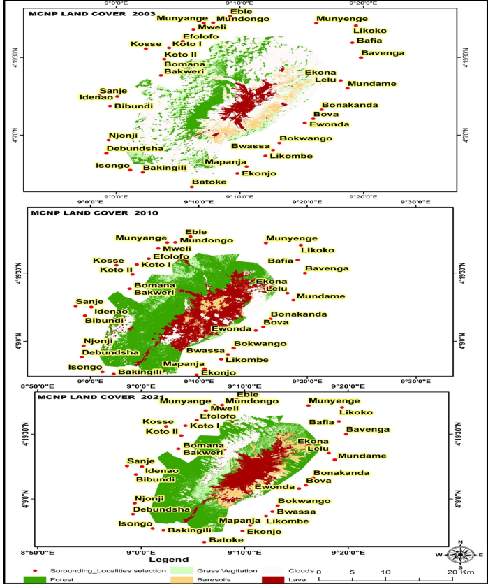
Changes in land cover within Mount Cameroon National park between 2003 and 2021 are shown on Figure 5. Land cover change analysis over the period 2003 to 2021 revealed four important land cover changes; forest, grassland, bare soils and rocks as shown on Table 4. The results revealed that the forest coverage recorded a steady increase between 2003 and 2010 and a decrease in the year 2021 (Figure 6 & Table 4). The total surface area occupied by the dense forest was 10841.7ha, 33432.6ha and 32409ha (90.9%) respectively for 2003, 2010 and 2020 (Table 4) representing a total forest loss of 1,023.6 hectares and an annual loss of 102.36 hectares. The increase in the forest area is similar to the findings of Htun et al 2017, who enumerated the exacerbating factors for forest cover increment. According to them the main anthropogenic factor which causes a rise in forest cover is a reduction in agricultural activities. The decrease in the forest area can be attributed to population increase and reduction in the population participation and also due to the socio-political crisis. Grassland showed a steady increase from 6711.7ha in 2003, to 6800.7ha in 2010 and 8600.2ha in 2021.This is attributed to deforestation. Bare soils and lava rocks also recorded fluctuations which can be affiliated to small scale subsistence farming within forested areas. Inhabitants of Bonakanda, and Bova are noted for such practices. Gibson 2007, added that increase in bare lands can also be a climate change indication which can also be confirmed in this study.
Figure 5:Risks involved in carrying out illegal activities.
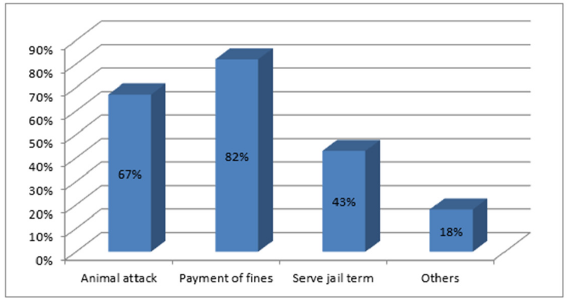
Table 4:Land covers statistics between 2003 and 2020 in the Mount Cameroon forest.

Figure 6:Land use / land cover change for the periods: 2003, 2010 and 2021 within MCNP.
Effectiveness of forest conservation policies
Respondents’ perception on the compliance and effectiveness of forest conservation laws/policies: The compliance and effectiveness of laws/policies implemented to conserve the MCNP was investigated based on respondents’ appreciation. In this light, 78% of the sampled population expressed the view that they respect the laws/policies that have been put in place and 22% stated the laws are not being respected. The respondents were asked to rate the effectiveness of the laws based on their appreciation and the results are shown on Figure 7. From Figure 7 49% of the respondents were of the opinion that the laws were effective, 23% identified the laws as very effective while 28% said the laws are not effective, The effectiveness of forest policies in conserving the MCNP was investigated and the results are presented on Table 5.
Figure 7:Respondents’ views on the effectiveness of forest conservation laws within the MCNP.
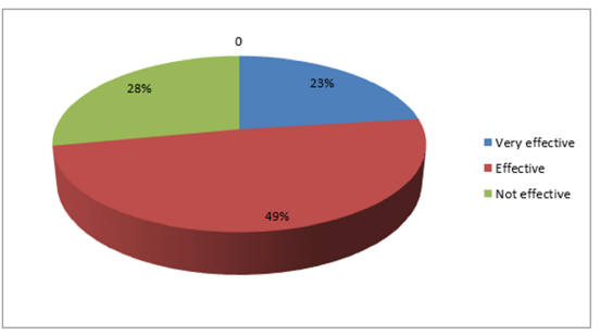
Table 5:Test of hypothesis on the effectiveness of forest conservation policies.

Results of the chi square analysis revealed that forest conservation policies in the area are not effective. This is also evident in the results of land cover change. Results are in line with the findings of Rudel [35] who highlighted that economic and agricultural reasons are more powerful drivers of land cover change than the regulations and incentives provided by environmental administrations. The negative attitude displayed by local communities towards forest conservation is due to the fact that most FAC are generally poor. The researcher observed that the rural people tend to practice a subsistence economy where they collect their daily needs such as food, drink, fuel, building materials and the like from the immediate environment freely. Hence the tendency to destroy and deplete the resources with no corresponding conservation effort is predominant. It is in the light of this that the results agree with the finding of [36-38] who variously posited that man’s attitude towards forest conservation is very negative. This has been displayed by the continual involvement in hash, aggressive and devastating activities towards forest conservation.
Conclusion and Recommendation
The study revealed a mixed perception expressed by the local communities towards the current policies in conserving and managing forest. Results further show that there exist no relationship between the age and sex of respondents and the level of educational attainment. The level of education of community members has a highly significant impact on law compliance, risk of entering into the reserve and opinions about laws within protected areas. Despite the mixed reactions expressed by the sampled communities, forest cover showed a decline while grassland was on the increase indicating that conservation policies are not effective. In line with the findings, the study proposes the following recommendations in order to guarantee the effective conservation and management of the MCNP. The study suggests putting in place alternative income generating activities in order to alleviate poverty in the communities. Micro projects such as piggery, poultry, sheep rearing, goat rearing, bee farming and intensive farming of both subsistence and cash crops should be encouraged further from the conserved zone. This will help empower the people economically and divert their attention from the MCNP forest resources. Education and sensitization programmed should be designed and vigorously implemented. There is a need to introduce and strengthen environmental education at primary, secondary and university levels and also increase community participation (bottom-top approach) in decision making and conservation.
References
- Dudley N (2008) Guidelines for applying protected area management categories.
- Abuzinada AH (2003) The role of protected areas in conserving biological.
- Charnley S, Fischer AP, Jones ET (2007) Integrating traditional and local ecological knowledge into forest biodiversity conservation in the Pacific Northwest. Forest Ecology and Management 246(1): 14-28.
- Jim CY, SS W Xu (2002) Stifled Stakeholders and subdued participation: Interpreting local responses toward Shimentai nature reserve in South China. Environ Manage 30(3): 327-341.
- Anthony B (2007) The dual nature of parks: Attitudes of neighbouring communities towards Kruger National Park, South Africa. Environmental Conservation 34(3): 236-245.
- Hamilton A, A Cunningham, D Byarugaba, F Kayanja (2000) Conservation in a region of political instability: Bwindi impenetrable forest, Uganda. Conservation Biology 14(6): 1722-1725.
- Watts S, H Faasen (2009) Community-based conflict resolution strategies for sustainable management of the Tsitsikamma national park, South Africa. South African Geographical Journal 91: 25-37.
- Naughton-Treves L, Buck Holland M, Brandon K (2005) The role of protected areas in conserving biodiversity and sustainable livelihoods. Annual Review of Environment and Resources 30: 219-252.
- Allendorf T, KK Swe, T Oo, Y Htut, M Aung, et al. (2006) Community attitudes toward three protected areas in Upper Myanmar. Environ Conserv 33(4): 344-352.
- Ramakrishnan PS (2007) Traditional Forest knowledge and sustainable forestry: A north-east India perspective. Forest Ecology and Management 249(1-2): 91-99.
- Weladji R, Moe S, Vedeld P (2003) Stakeholder attitudes wildlife policy and Bénoué Wildlife Conservation Area, North Cameroon. Environmental Conservation 30(4): 334-343.
- FAO (2005) Global Forest resources assessment, UN Food and Agriculture Organisation, Rome, Italy.
- Jai N Mehta, Joel T Heinen (2001) Does community-based conservation shape favorable attitudes among locals? An empirical study from Nepal. Environ Manage 28(2): 165-177.
- Stern N (2007) The economics of climate change: The stern review, Cambridge University Press, Cambridge, UK.
- Wambui KS (2002) Community participation in forest resources management in Mt. Elgon Forest and its Environs, Kenyatta University, Kiambu, Kenya.
- Brandon KE, Wells M (1992) Planning for people and parks: Design dilemmas. World Dev 20(4): 557-570.
- Usongo Ajonina P, Gordon Ajonina N, Tepoule Joseph N, Guy Ediamam E (2021) Potentials of protected areas as carbon Sinks and implication on climate change in Cameroon. J Earth Sci Clim Change 12(4): 6-12.
- Alkan H, M Korkmaz, A Tolunay (2009) Assessment of primary factors causing positive or negative local perceptions on protected areas. J Environ Eng Landscape Manage 17(1): 20-27.
- Khan MS, SA Bhagwat (2010) Protected areas: A resource or constraint for local people: A study at Chitral Gol National Park, North-West Frontier Province, Pakistan. Mountain Res Dev 30(1): 14-24.
- Wells MP, TO McShane (2004) Integrating protected area management with local needs and aspirations. Ambio 33(8):513-519.
- Xu J, L Chen, Y Lu, B Fu (2006) Local people’s perceptions as decision support for protected area management in Wolong Biosphere Reserve, China. J Environ Manage 78: 362-372.
- Leuschner C (2000) Are high elevations in tropical mountains arid environments for plants? Ecology 81(5): 1425-1436.
- Cable S, M Cheek (1998) The plants of mount Cameroon: A conservation checklist. Royal Botanic Gardens, Kew, Richmond, UK.
- MINEF (2002) A management plan for Korup National Park and its Peripheral Zones 2002-2007. Republic of Cameroon mineralization in a central African rain forest dominated by ectomycorrhizal.
- Neba A (1987) Modern geography of the republic of Cameroon, (2nd edn), Neba Publishers, Bamenda, Cameroon.
- Ekane NB (2000) The socio economic impact of prunus Africana management in the mount Cameroon region; Case study of the Bukwango community, M Sc Thesis, Department of Urban Planning and Environment, Royal Institute of Technology Stockholm, Stockholm, Sweden.
- Meffe GK, Carroll RC (1994) Principles of conservation biology, Sinauer Associates Inc Publishers, Sunderland, Massachusetts, USA.
- Kaufmann RK, KC Seto (2001) Change detection, accuracy, and bias in a sequential analysis of Landsat imagery: A time series technique. Agric Ecosyst Environ 85(1-3): 95-105.
- Kashaigili JJ (2006) Land covers dynamics and hydrological functioning of wetlands in the Usangu plains in Tanzania, Thesis for Award of PhD Degree at Sokoine University of Agriculture, Morogoro, Tanzania, p. 266.
- Tear TH, P Kareiva, PL Angermeier, P Comer, B Czech, et al. (2005) How much is enough? The recurrent problem of setting measurable objectives in conservation. Bioscience 55(10): 835-849.
- Rosenau NJ (1999) Change, complexity and governance in globalizing space. In: Pierre J (Eds.), Debating Governance, Oxford University Press, Oxford, UK, pp. 176-2000.
- Mayntz R (2003) New challenges to governance theory. In: Bang PH (Eds.), Governance as social and political communication, Manchester University Press, Manchester, England, UK, pp. 27-40.
- Ajonina P Usongo, Ediamam E Guy, Tepoule N Joseph, Dongang C Mangwa, Fonbe L Fon (2017) Perception and Attitude of Indigenous Population around Protected Areas and Impact on Land Cover Change: Case study of the Bakossi National Park Cameroon. In: Fred L Rogers (Ed.), Deforestation and Afforestation Global Challenges, Management and Environmental Implications, Nova Science Publishers, New York, USA.
- Vitousek PM, Mooney HA, Lubchenco J, Melillo JM (1997) Human domination of earth’s ecosystems. Science 277: 494-499.
- Rudel TK (2017) Tropical forests: Regional paths of destruction and regeneration in the late 20th century Columbia University Press, New York, USA.
- Obot AE (1995) Psychological issues in environmental education. In: Ukpong EM, Ntia UN, Obot AE, Ewa NU (Eds.), Community Environmental Education, Macmillan Nigeria Publications, Lagos, Nigeria.
- Smart KC (1998) An introduction to global environmental issues. Society & Natural Resources: An International Journal 8: 743-758.
- Usang FN (1995) The learning community in a living environment. In: Ukpong EM, Ntia UN, Obot AE, Ewa NU (Eds.), Community environmental education, Macmillan Nigeria Publications, Lagos, Nigeria.
© 2024 © Usongo A Patience. This is an open access article distributed under the terms of the Creative Commons Attribution License , which permits unrestricted use, distribution, and build upon your work non-commercially.
 a Creative Commons Attribution 4.0 International License. Based on a work at www.crimsonpublishers.com.
Best viewed in


.jpg)


 Editorial Board Registrations
 Submit your Article
 Refer a Friend
 Advertise With Us
.jpg)


.jpg)


.bmp)
.jpg)
.png)
.jpg)


.jpg)


.png)

.png)


.png)


