- Submissions

Full Text
Environmental Analysis & Ecology Studies
Urban Flood Intricacies and Implications in Uyo Capital City, Akwa Ibom State, Nigeria
Comfort Abraham1*, Enobong Umoh1, Edidiong Otu2 and Oscar Ita2
1Department of Geography and Natural Resources Management, University of Uyo, Nigeria
2Clement Isong Centre for Development Studies, Nigeria
*Corresponding author:Comfort Abraham, Department of Geography and Natural Resources Management, University of Uyo, Nigeria
Submission: May 09, 2023; Published: June 27, 2023

ISSN 2578-0336 Volume11 Issue2
Abstract
The work examined urban flood intricacies and Implications in Uyo Capital City, Akwa Ibom State, Nigeria with a view to reducing negative flood related scenario that is detrimental to sustainable urban environment. To achieve this, seven flood sites were identified with different depths of drains in the study area. Therefore, flood intricacies are facilitated by natural consequences which further is provoked by anthropogenic parameters such as; road without drains 19.1%, heavy and prolonged rainfall 24.6%, topography 10.2%, dumping of wastes in gutter 13.2%, urban surface characteristics with high cemented surfaces 6%, houses built on watershed 6.2% amongst others. The study pinpoints that flood dynamics is multifaceted with dire consequences on the wholesomeness of Uyo Capital City in terms of loss of lives and properties, disrupted communication routes, and other social impacts. The work recommended that sensitization of residents on human components of flood scenario with appropriate town planning laws must be put in place. Above all, Uyo Capital City must make waste evacuation and management internalized amongst residents for sustainable urban space.
Keywords:Urban flood intricacies; Implication; Uyo capital city; Akwa Ibom state; Nigeria
Introduction
Over the years, the world has witnessed several notable disasters scenario which have caused large fatalities lately. Consequently, this has resulted in devastating economic losses with intensification in environmental degradation. The most significant impact experienced so far in flood impacted domain of Akwa Ibom State and elsewhere. This scenario is mostly felt at community level with dire consequences [1]. Floods are among the most devastating natural disasters in the world, claiming more lives and causing damage to properties than any other natural phenomena, with widespread negative scenarios [2]. Statistically, every year approximately 100 million people are affected by episodes of flooding globally. Developing countries especially in the African continent are vulnerable due to the weakness of state infrastructure and absence of implementation of town planning policies guiding flood disaster reduction and prevention. Nigeria is one of the most disaster-prone countries in Africa, and floods are the most common and recurring natural disaster, with high frequency, severity, and dire consequences [3]. The increase in flood scenarios is orchestrated by varied human activities that interfere with watershed [4].
Urban flooding is an overflow of water that inundates land. This usually occurs due to the volume of water exceeding infiltration capacity, resulting in some water flowing outside of the normal drainages [5]. Floods are among the most felt natural scenarios, impacting upon human lives, and causing severe economic damage throughout the globe [6]. Overtime, flood risks vary in intensity and frequency globally [7] due to rapid accumulation of runoff after heavy rainfall with discharges reaching a maximum level significantly. The occurrence of flooding in cities is intensified with a high percentage of cemented surfaces as urbanization increased with high proportion of fatalities and casualties [8]. The potential for flood casualties and damage is also increasing in many regions due to the social and economic development, which imply pressure on land-use, e.g., through urbanization and high standard of living.
Urban floods are from extreme meteorological events like heavy rainfall causing overflow with far-reaching effects on people and the environment. Flood is accumulation of excess water which rises to overflow land that is not normally submerged [9]. According to Disaster Management Support Group (DMSG, 2001), flooding is one of the most devastating natural hazards in the world, leading to significant economic and social damages than any other natural phenomenon put together. Extensive damages, both in terms of loss of lives and properties, have been recorded globally. In India, 125 people were killed and over 12 million people were displaced in the 2007 flood disaster that hit Bihar, Uttar Pradesh, and Assam province [7]. African countries have not been left out in this global flood experience. In 2001, the central provinces of Mozambique were hit by flood disaster that affected 554,000 people and resulted in 113 deaths. In Nigeria, devastating flood scenarios can be dated back to 1963 in Ibadan city, Oyo State, when Ogunpa River was over-flown with negative environmental impact. Since then, the occurrence of floods has spread nationwide especially 2012 flood in Nigeria. More than half of the 36 States in Nigeria have been hit by one form of flood or another. The states that have been badly affected by floods in the country include Kano, Niger, Jigawa, Kaduna, Adamawa, Benue, Kogi and other states in the southern parts of Nigeria especially 2012 flood.
Floods are natural phenomena, but they become a cause for serious concern when they exceed the coping capacities of affected communities, damaging lives and property. Globally floods are the most frequently occurring destructive natural event affecting both rural and urban settlements [10]. Flood damages refer to all varieties of harm caused by flooding. It encompasses a wide range of harmful effects on humans, their health and belonging on public infrastructure, cultural heritage, ecological system, industrial production and the competitive strength of the affected economy. Flood damages differ occasionally but are mostly categorized firstly into direct and indirect damages and secondly, tangible, and intangible damages. Flood damage covers all varieties of harms which relate to the immediate physical contact of flood water to human property, and the environment. This includes for example damage to buildings, economic assets, loss of farm crops and livestock in agriculture, loss of human life, immediate health impacts and loss of ecological goods. Indirect flood damages are caused by disruption of physical and economic linkages and the extra costs of emergency and other actions taken to prevent flood damage and other losses. But damages which can be specified in monetary terms such as loss of production are called tangible damages and those that cannot be valued in monetary terms such as casualties, health effects and damages to ecological goods which are not traded in the market are far more difficult to assess in monetary terms.
The aim of the study is to examine urban flood dynamics and
its implication in Uyo Capital City, Akwa Ibom State. However, the
specific objectives to guide the work include.
A. Identifying the factors causing floods in Uyo Capital City.
B. Mapping out flood vulnerable areas within Uyo Capital
City.
C. Examining the dynamic parameters of flood incidence in
the study area.
D. Assessing the impact of the flood incidence on socioeconomic
activities of the area.
E. Suggesting remedial measures to urban flood incidence in
Uyo, Akwa Ibom State.
Literature Review
Urban flood dynamic scenario
Urban flooding has featured in local and international fora indicating the severity of the problem in recent time. The current trend and future scenarios of urban flooding rests on concrete scientific collaboration by researchers globally. This therefore demands urgent attention to reduce negative tendencies from multifaceted urban dimensions. Urbanization with attendant conversion of agricultural land, natural vegetation and singlehandedly to built-up environments with high construction on natural drainages make vulnerable areas risk-driven over time. In addition to population growth and the ongoing accumulation of valuable assets, both the frequency and magnitude of floods due to climate change scenarios are expected to increase in the future, therefore aggravating the existing flood risk in urban areas. This scenario implies that urban areas in particular suffer from a comparatively high flood risk due to high population and density, multiple economic activities and many infrastructure and property values, which in turn interferes with the natural infiltration processes due to cemented surfaces.
Urban flooding is a common problem every year in many cities across Nigeria, but the impacts of flooding are poorly documented and portrayed. There is no consistent set of statistics at a local or national level that can be used to compare the impacts of flooding across cities, and reports that focus on particular flood events are often incomplete [11]. However, the inability of city authorities to control urban development is a major factor contributing to increased exposure to flood hazards and risk. Existing regulations on town planning by state government discourage development on marginal lands and watershed to reduce flood incidences. However, despite these incentives and regulations, large numbers of buildings and other structures have been built and are still being built on drainage paths, floodplains, and close to watersheds. For instance, in Lagos, the total economic losses due to flooding across the state have been estimated at USD 4 billion per year, which is 4.1% of the state’s GDP or 1.0% of national GDP [12]. In Ibadan (Oyo State), average annual losses due to flooding have been estimated at USD 105.3 million per year [13]. Between 2000 and 2015, floods are estimated to have killed 129 people, destroyed 3,102 homes, and damaged 9,112 homes [14]. In Calabar (Cross River State), and Makurdi (Benue State), flooding is an annual occurrence but very little information is available about the impacts of flooding, apart from limited evidence about the impacts of a few specific flood events. The evidence base for flood impacts, risks, and mitigation efforts at the city level in Nigeria is limited, and much of the information available is low quality, inconsistent, or outdated with scientific barriers.
Some of the causal factors of flood disasters in Nigeria include land inundation from heavy rainfall, climate change, and blockage of drainages with refuse, construction of buildings across drainages, inadequate drainage networks, and population increase in urban areas. These factors do not act independently and flood disasters usually occur from a combination of several of them. The highrisk potential of floods in particular may be related to their rapid occurrence and spatial dispersion of the areas which is impacted by these floods. In flood prone areas, runoff rates often far exceed those of other areas due to the rapid response of the catchments to intense rainfall, modulated by soil moisture and soil hydraulic properties. The small spatial and temporal scales of floods, relative to the sampling characteristics of conventional rain and discharge measurement networks, make also these events particularly difficult to observe and predict [8].
Changes in the urban environment and storm intensity produce higher flows that exceed the capacity of small culverts aligned in a few road intersections designed in Uyo Capital City. Although such structures can be adequate when designed, their capacity now turns out to be inadequate and thereby cause overflows onto the roads creating new water paths and flood the rapidly growing builtup areas. In developing countries, inadequate maintenance of the drainage channels, and debris and solid waste disposed into such drainage systems help accentuate the situation. The rainfall runoff process, however, is highly complex, non-linear, and temporally and spatially varying because of the variability of the terrain and climate attributes. Seasonally, Uyo capital city and perhaps many parts of Akwa Ibom State are faced with flooding to the extent that damage is caused to human lives and other properties, whenever rain occurs. Due to the topography of the state capital, rainwater overflows the drainage thereby causing devastating floods in the state capital. For the past years, a large portion of settlements, agricultural lands and other landed properties are always flooded after torrential rains. This has brought a lot of difficulties and untold hardship to the affected victims in flood prone zones lately.
Materials and Methods
The study area
Uyo Capital city, Akwa Ibom State, Nigeria consists of all the areas within a radius of 10 kilometers measured from Ibom connection (a major roundabout at the heart of the city). It was demarcated by Uyo Capital City Development Authority law, CAP 136 of 1988. The city limit incorporates parts of nearby LGAs, such as Itu, Uruan, Ikono, Nsit Ibom, Ibiono Ibom and Ibesikpo Asutan. Uyo Capital City doubles as the municipal council headquarters of Uyo Local Government Area (LGA) as well as the capital of Akwa Ibom State (Ofem, and Udida,2014). The city became the State capital on September 23, 1987 following the creation of Akwa Ibom State from erstwhile Cross River State, Calabar.
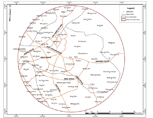
Uyo Capital City lies between latitudes 4°58’ and 5°04’N and longitudes 7°51’ and 8°01’E. It is bounded in the north by Ikono, Itu and Ibiono Ibom L.G.A.s. In the East, it shares a boundary with Uruan LGA, while in the south it borders with Ibesikpo Asutan and Nsit Ibom L.G.A.s (Figure 1). Uyo Capital city is situated on an average elevation of 60.96 meters above sea level (Njungbwen, 2011). The city covers an area of about 214.31 square kilometers and is one of the fastest growing cities in Nigeria. The city can be accessed by road via the Abak road, Nwaniba road, Calabar-Itu road and Aka-Nung Udoe road, Ikot Ekpene road and Oron road (Figure 2).
Uyo Capital City is under the influence of two important air masses which include: Tropical Maritime (mT) and Tropical Intercontinental (cT) air masses. These air masses determine the seasons in the area. It is located within the tropics hence, experiences tropical/equatorial climate. Uyo Capital City has two distinct seasons which include rainy and dry seasons. The rainy season lasts between March and October; and enjoys bimodal peaks of rainfall in July and September, with occurrence of a short dry spell in August referred to as August Break. The dry season on the other is short and lasts from November to February. During this period, the area is influenced by cT air mass that is associated with dry and dusty wind (Inyang, 2000). Sometimes, the harmattan period lasts for only a few weeks between December and January. This is usually advantageous to the farmers because it is congenial for harvesting and the storage of food crop. The mean annual rainfall of Uyo is 2316mm (Inyang, 2000; Ekanem, 2010). Temperature is relatively high in Uyo throughout the year; with the mean annual temperatures of about 26-28 °C. The relative humidity varies from about 75% to 95% with the highest and lowest values in July and January respectively.
The 2019 human population of Uyo Capital city as projected from the 2006 National Population Commission (NPC) figures of 356,964 using an acceptable growth rate of 3.4 percent was 496,537. Uyo is a fast-growing city with a lot of infrastructural development especially in the area of transportation and urban renewal. The closest airports to the city include the Akwa Ibom International Airport at Okobo and Margaret Ekpo International Airport at Calabar. It has an intensive internal network of roads such as the IBB Way, Atiku Abubakar Avenue, Udo Udoma Avenue, Nsikak Eduok Avenue, Edet Akpan Avenue, Stadium and Idoro roads respectively.
Figure 1:Akwa Ibom state showing the location of Uyo capital city.
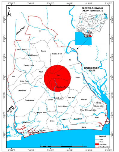
Figure 2:Uyo capital city showing settlements.
Research Methods
Data on the socio-economic status of residents, factors causing flooding, dynamic parameters of flood incidence and impact of flooding was obtained from structured questionnaires in flood prone streets (Table 1). Altogether 430 questionnaires (96.5%) were distributed accordingly to obtain response in flood hazardous scenarios and its effect on resident and socio-economic development was used in one-way Anova and Chi-square.
The satellite imagery of the selected streets was used in selecting the sampled population, buildings that are within 100m from the flood sites were counted and used to represent the study. In each of the affected buildings, one person (the household head) was selected as a representation for the study. In each street, 20% of the buildings constitute the sampled population. Thus, the number of respondents in each of the selected flood street is summarized (Figure 3 & 4) (Table 2).
Table 1:Sampled Population based on the number of buildings.

Source: Satellite Imagery of Uyo (2021).
Figure 3:Age distribution of respondents.
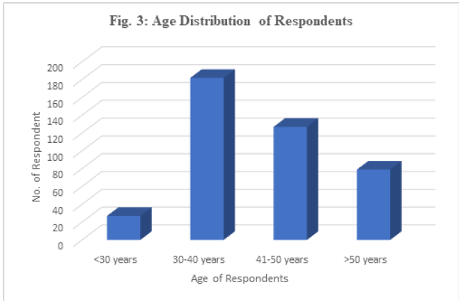
Figure 4:Occupation of respondents.
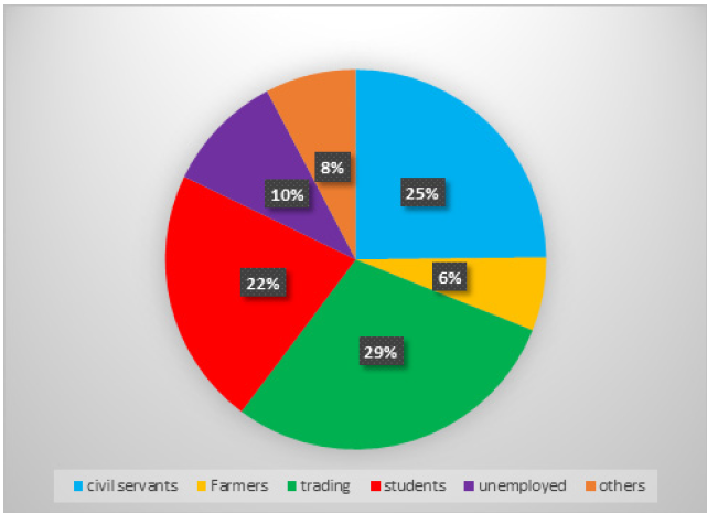
Table 2:Marital Status of Respondents..

Demographic characteristics of respondents
Gender of Respondents had 51.81% for male and 48.2% for female (Figure 5) (Table 3).
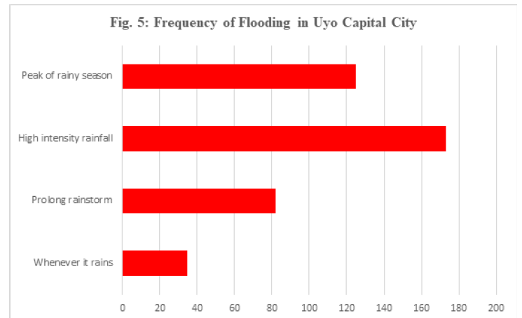
Figure 6 shows that flooding mostly occurs only when there is high intensity of rainfall. Consequently, 173 respondents (41.7%) agree that flooding occurs when there is high rainfall intensity. Similarly, 125 (30.15) of respondents agree that flooding occurs during the peak of raining season (June, July and September). Only 89.4% insist that flooding occurs whenever it rains while 19.8% attribute it to prolong rainstorms.
Table 3:Educational status of respondents.

Figure 5:Dynamic characteristics of flood scenario in Uyo and Implication for wholesome environment.
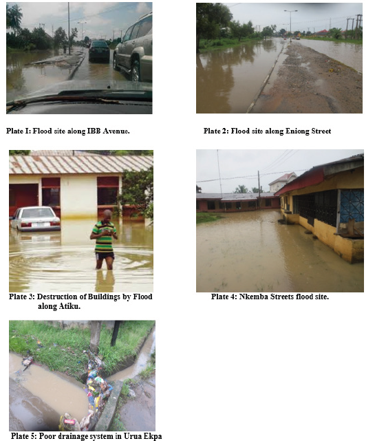
Figure 6:Frequency of flooding in Uyo capital city.
Estimated depth of flood water in Uyo capital city
Table 4 shows that the dominant depth of flood water in the area is at knee depth (44.3%), followed by ankle deep (21.9%), waist depth (17.8%) and above shoulder (15.9%) respectively. In Figure 7 the recession time of flooding occurs mainly between 3-6 hours (34.2%), followed by 1-3 hours (27%). 24.6% of the respondents indicate that it takes days for the flood water to recessed while only 3.9% of flood recessed in less than 30 minutes.
Figure 7:Recession time of flood.
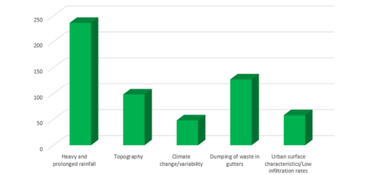
Table 4:Depth of flood water in Uyo Capital City.

Causes of flooding in Uyo capital city
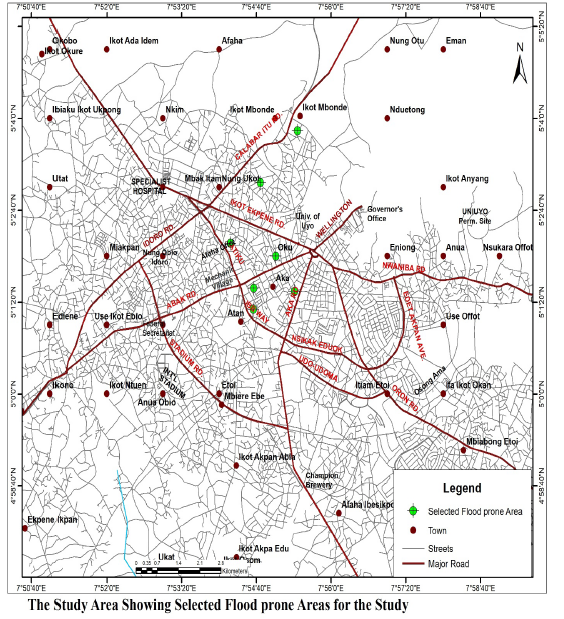
According to respondents, heavy and prolong rainfall remains the major causes of flooding in the area (Figure 8). This is followed by poor drainage network, dumping of waste in gutters and topography respectively. Others include haphazard dumping of solid waste, deforestation/inappropriate agricultural land use, houses built across depressions and climate change/variability respectively (Figure 9) (Table 5).
Figure 8:Factors of flooding in Uyo capital city.
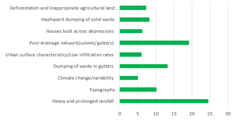
Table 5:Causes of flooding in Uyo capital city.
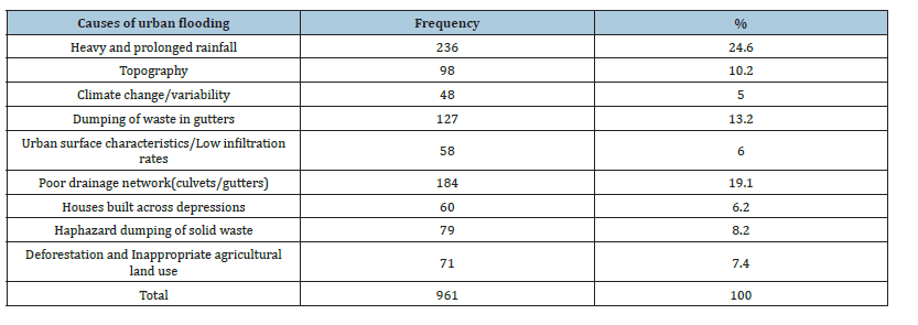
Figure 9:Mapping of flood vulnerable areas in Uyo capital city.
Testing of hypothesis one: Ho1: There is no significant differences in the incidence of flooding in Uyo Capital City. The result of the analysis yielded F value of 136.007 with 6,408 Degrees of Freedom (df) and P-value of 0.000. However, since the P-value is less than 0.05 (level of significance), it therefore implies that the Ho is rejected which mean that there is a significant difference in the incidence of flooding in Uyo Capital City (Table 6).
Table 6:Causes of flooding in Uyo capital city.

Testing of hypothesis two: Ho2:There is no significant impact of the flood incidence on socio-economic activities in Uyo Capital City. The hypotheses testing using Chi-Square shows 469.927 with 25 degree of freedom (df) and P-value of 0.000 (P<0.05) which therefore implies that there is a significant impact of the flood incidence on socio-economic activities in Uyo Capital City, AKS (Table 7).
Table 7:Chi-Square summary table for hypothesis two.

Discussion of Findings
Having examined urban flood dynamics and its implication in Uyo Capital City, the study identified the most vulnerable areas to flood in Uyo Capital City such as IBB, Atiku Abubakar, Esuene Street, Nkemba, Udoette, Urua Ekpa, among other streets. This corresponds with the work of Ituen U et al. [15] with similar vulnerable streets to flood disaster in Uyo Capital City. More so, heavy and prolonged rainfall was the major factor of flooding in Uyo Capital City, followed by topography, poor drainage network, dumping of waste in gutters, building along water channels/depression, among others
The hypotheses tested show that there is a significance difference in the incidence of flood in Uyo. Based on respondent’s perception IBB recorded the highest level of flood disaster in the Capital City, this is followed by Atiku Abubakar, Esuene Street, Urua Ekpa and Nkemba Street respectively. The study also noted that some part of Uyo is flood free due to several factors especially the topography. This simply shows that there exists a big difference in the occurrence of flood disaster in Uyo Capital City. The second hypothesis shows that there is a significant impact of the flood incidence on socio-economic activities in Uyo Capital City. The result shows that the negative impact include impacts on public utilities, impacts on agricultural and farming activities, impacts on household properties/equipment, disruption of economic activities, epidemics e.g., cholera, malaria, dysentery and etc. and loss of life, migration and displacement of people, among others.
Comparatively, this study agrees with the work of Hu et al. [16] which investigated the impact of flooding on the Chinese economy from the perspective of the manufacturing sector and found that large flood events on average reduce firm outputs (measured by labour productivity) by about 28.3% per year. It also goes in line with Umaru et al. [17] result which showed that flooding caused damage to household properties, vehicles, building collapse, farmlands, etc. in Lokoja, Kogi State. This study also agrees with Halley [18] who identifies the major cause of flood in Africa to be inadequacy of drainage channel with indiscriminate waste dump into existing drains.
Conclusion and Way Forward
Flood disasters is no longer a new phenomenon with it attendant destruction of lives and properties. Sometimes it is predictable but to what extent the harm and destruction will occur can only be best imagined [19-24]. Though flood occurs naturally but human activities influence the occurrence. Disaster management, flood abatement and erosion control require adequate priority for prevention of hazards, sustainable development, rapid urban growth and infrastructural development, national security, protection of life and property [25-30]. Every strategy which will curtail flood and erosion must be implemented to avert natural hazard and to make sure that development efforts do not aggravate vulnerability to those hazards in view of incessant and destructive effects of flood and erosion tragedy globally [31-40]. The pattern of flooding in Uyo is dynamic in nature. High level of flood disaster is witnessed along IBB Avenue, Atiku Abubakar, Esuene Street, Urua Ekpa, Nkemba Street among others due to factors such as heavy and prolonged rainfall topography, poor drainage network, dumping of waste in gutters, building along water channels/depression, among others. The resulted in high level of economic hardship, migration and displacement of people from their houses, among others [41- 47].
Based on the findings from this study, the way forward:
A. Enlightenment programs through environmental
education should be organized periodically for sensitization
on the causes, effects, and possible preventive measures of
flooding.
B. Appropriate environmental law should be put in place to
prevent indiscriminate dumping of refuse on drainage channels
as well as bringing offenders to book through creation of mobile
court to try and punish whoever abuses the environment
intentionally.
C. There should be appropriate frameworks on good urban
governance and town planning for building regulations and
drains.
D. Tree planting in the environment is of great importance
to control flooding: rainstorms and ocean surge, tree planting
should be encouraged and there should be demolition of
structures within the flood prone areas and rivers setbacks
which obstruct free flow of water.
References
- Buba FN, Obaguo S, Ogar O, Ajayi FO (2021) A participatory assessment of the impact of flooding in some communities in Lokoja, Kogi state, Nigeria. American Journal of Climate Change 10(1): 12-31.
- Kundu A, Kundu S (2011) Flood vulnerability assessment using PGIS approach. Journal of Remote Sensing and GIS 2: 8-22.
- Federal Government of Nigeria (2013) Nigeria post-disaster needs assessment: 2012 floods, A Report by the FGN with technical support from the World Bank, European Union, United Nations, and other partners.
- Abdullahi SO (2021) The courses and effect of flooding in Ibaji L G A of Kogi State, Nigeria. Journal of Environmental Science Toxicology and Food Technology 15(3): 9-26.
- Wizor CH, Mpigi GL (2020) Geospatial mapping of urban flood-prone areas in port Harcourt metropolis: Implications for effective urban physical planning in Nigeria. World Journal of Innovative Research 8(1): 17-25.
- Khan SI, Hong Y, Wang J, Yilmaz KK, Gourley JJ, et al. (2011) Satellite remote sensing and hydrologic modeling for flood inundation mapping in Lake Victoria basin: Implications for hydrologic prediction in ungagged basins. IEEE Transportation Geoscience Remote Sensing 49(1): 85-95.
- Isa I, Kolawole HM, Abayomi TA, Oyekanmi B, Olusola IG, et al. (2015) Suitability analysis of resettlement sites for flood disaster victims in Lokoja environs. American Journal of Geographic Information System 5(3): 101-111.
- Borga M, Anagnostou EN, Blöschl G, Creutin JD (2011) Flash flood forecasting, warning and risk management: The hydrate project. Journal for Environmental Science Policy 14: 834–844.
- Mukhopadhyay S (2010) A geo-environmental assessment of flood dynamics in lower Ajor river inducing sand splay problem in eastern India. Ethiopian Journal of environmental Studies and Management 3(2): 96-110.
- Dihn Q, Balica S, Popescu I, Jonoski A (2012) Climate change impact on flood vulnerability, vulnerability and risk of the Long Xuyen quadrangle in the Mekong delta. International Journal River Basin Management 10(1): 103-120.
- Lucas B (2021) Urban flood management in Nigeria, K4D Helpdesk Report 948, Institute of Development Studies, Brighton, UK.
- Croitoru L, Miranda JJ, Khattabi A, Lee JJ (2020) The cost of coastal zone degradation in Nigeria: Cross River, Delta and Lagos States. World Bank Group, Washington DC, USA.
- World Bank (2014) Project appraisal document on a proposed credit in the amount of SDR 129.1 Million (US$200 Million Equivalent) to the federal republic of Nigeria for the Ibadan flood management project. World Bank, Washington DC, USA.
- Adekola O, Lamond J, Adelekan I, Eze EB (2020) Evaluating flood adaptation governance in the city of Calabar, Nigeria. Climate and Development 12(9): 840–853.
- Ituen U, Imoh J, Ndifreke N (2014) Flood hazard assessment and decisions support using geographic information system: A case study of Uyo capital city, Akwa Ibom state, Nigeria. International Journal of Geography and Geology 3(4): 56-67.
- Hu X, Pant R, Hall JW, Surminski S, Huang J (2019) Multi-scale assessment of the economic impacts of flooding: Evidence from firm to macro-level analysis in the Chinese manufacturing sector. Sustainability 11: 1-18.
- Umaru JU, Hafiz SS (2019) Perceived effects of flood on lives and properties of the residents of Lokoja, Kogi State, Nigeria. Discovery 55(284): 441-452.
- Halley (2001) Impact of 1998 flood nutrition and health. What can we learn from future disaster? Helen Keller International, and Institute of Public Health Nutrition, Dhaka, Bangladesh.
- Abam TKS (2005) Soil exploration and foundations in recent coastal areas of Nigeria. Bulletin of Engineering Geology and the Environment 53: 13-19.
- Adaku Jane Echendu (2020) The impact of flooding on Nigeria’s Sustainable Development Goals (SDGs). Ecosystem Health and Sustainability 6(1): 1-13.
- Adebayo WO, Jegede AO (2010) The environmental impact of flooding on transportation land use in Benin City, Nigeria. Africa: Research Review 4(1): 390-400.
- Adegbola AA, Jolayemi JK (2012) Historical rainfall-runoff modeling of river Ogunpa, Ibadan, Nigeria. Indian Journal of Science and Technology 5(5): 2725-2728.
- Adelekan IO (2010) Vulnerability of poor urban coastal communities to flooding in Lagos, Nigeria. Environment and Urbanization 22(2): 433-450
- Adelekan IO, Asiyanbi AP (2016) Flood risk perception in flood-affected communities in Lagos, Nigeria. Natural Hazards 80(1): 445–469.
- Adeoye NO, Ayanlade A, Babatimehin (2009) Climate change and menance of floods in Nigeria cities: Socio-economic implications. Advances in Natural and Applied Sciences 3(3): 369-377.
- Agbola B, Ajayi O, Taiwo O, Wahab B (2012) The August 2011 flood in Ibadan, Nigeria: Anthropogenic Causes and Consequences. International Journal of Disaster Risk Science 3: 207-217.
- Bankoff G (2003) Constructing vulnerability: The historical, natural and social generation of flooding in metropolitan Manila. Journal 27(3): 224-238.
- Kolawole OM, Olayemi AB, Ajayi KT (2011) Managing flood in Nigerian cities: Risk analysis and adaptation options–Ilorin City as a case study. Archives of Applied Science Research 3(1): 17-24.
- Lamond J, Adelekan I (2016) Mitigation of climate risks through adaptation and urban management in Nigerian cities. In: Costa PT, Quino D, Garcia RAC(Eds.), International Conference on Urban Risks. European Center for Urban Risks (CERU), Lisbon, Portugal, pp. 787-794.
- Ndoma EE (2015) Effectiveness of drainage networks on floods in Calabar metropolis, Ahmadu Bello University, Nigeria.
- OCHA (2003) Southern Africa: Mid-term review 2003. United Nations Office for the Coordination of Humanitarian Affairs, Geneva, Switzerland.
- Ojigi ML, Abdulkadir FI, Aderoju MO (2013) Geospatial mapping and analysis of the 2012 flood disaster in central parts of Nigeria. 8th National GIS Symposium, Dammam, Saudi Arabia.
- Oladokun V, D Proverbs (2016) Flood risk management in Nigeria: A review of the challenges and opportunities. Int J of Safety and Security Eng 6(3): 485-497.
- Olalekan A (2018) Many African countries are flooding, risking decades of development if they do not adapt. The Conversation, Melbourne, Victoria, Australia.
- Olanrewaju CC, Chitakira M, Olanrewaju OA, Louw E (2019) Impacts of flood disasters in Nigeria: A critical evaluation of health implications and management. Jàmbá 11(1): 1–9.
- Ologunorisa TE, Durowoju OS (2014) Extreme rainfall and urban flooding in a coastal megacity: A case study of Lagos, Nigeria. In: Abam TKS (Ed.) Flood and Erosion Prevention, Protection and Mitigation, Rivers State University of Science and Technology, Port Harcourt, Nigeria, pp. 85-102.
- Oluwaseyi OB (2019) Assessment of physical planning administration in Nigeria.
- Oriji CC (2015) What to do about climate change-caused flooding and the associated diseases in rivers state of Nigeria. Global Journal of Human-Social Science Research 15(4): 29-34.
- Oriola O (2003) Strategies for combating urban flooding in developing countries: A case study of Ondo state, Nigeria.
- Osabohien R, Osabuohien E, Urhie E (2018) Food security, institutional framework and technology: Examining the Nexus in Nigeria Using ARDL Approach. Current Nutrition and Food Science 14(2): 154–163.
- Oyebode O (2020) Hazard assessment and implementation strategies for mitigating of flood and erosion in Nigeria. IOP Conf Series: Materials Science and Engineering, Ota, Nigeria.
- Rabalao RT (2010) The social, psychological, and economic impact of flooding in Ga-Motla and Ga-Moeka Communities of Moretele district in northwest Province, South Africa, Unpublished master’s thesis, University of the Free State, Bloemfontein, South Africa.
- Resonzweig H (2009) Evaluation of flood hazards, management and mitigating measures. Journal of Environmental Management Sciences 18(2): 23-26
- Satterthwaite D (2017) The impact of urban development on risk in sub-Saharan Africa’s Cities with a focus on small and intermediate urban centres. International Journal of Disaster Risk Reduction 26: 16–23.
- Shabu T, Tyonum TE (2013) Residents coping measures in flood prone areas of Makurdi town, Benue state. Applied Ecology and Environmental Sciences 1(6): 120-125.
- Tawari-Fufeyin P, Paul M, Godleads AO (2015) Some aspects of a historic flooding in Nigeria and its effects on some Niger-Delta communities. American Journal of Water Resources 3(1): 7-16.
- Wright T (2011) Waterlogged: Pakistani children push a motorbike through flooded streets after rain on Lahore. In the Wall Street Journal Newspaper, London, UK.
© 2023 © Comfort Abraham. This is an open access article distributed under the terms of the Creative Commons Attribution License , which permits unrestricted use, distribution, and build upon your work non-commercially.
 a Creative Commons Attribution 4.0 International License. Based on a work at www.crimsonpublishers.com.
Best viewed in


.jpg)


 Editorial Board Registrations
 Submit your Article
 Refer a Friend
 Advertise With Us
.jpg)


.jpg)


.bmp)
.jpg)
.png)
.jpg)


.jpg)


.png)

.png)


.png)


