- Submissions

Full Text
Environmental Analysis & Ecology Studies
Observational vs. GPS Data: The Case of Spatial and Social Ecology of the Andean Vicuña (Vicugna vicugna)
William L Franklin*
Department of Natural Resource Ecology & Management, Iowa State University, USA
*Corresponding author:William L Franklin, Professor Emeritus Iowa State University, Department of Natural Resource Ecology & Management, Iowa State University, USA
Submission: April 03, 2023; Published: April 18, 2023

ISSN 2578-0336 Volume10 Issue5
Abstract
What is the most appropriate approach for researching spatial and social ecology of the open-habitat Andean Vicuña (Vicugna vicugna): Global Positioning System (GPS) or observational methodologies? Both provide large sample sizes for analysis. The Vicuña is a high-altitude ungulate, sedentary, and non-migratory with year-round territoriality forming the basis of its social organization and habitat use. Systematic observational methods yield in-depth details on daily and seasonal movements of primary social groups and individual feeding habits by plant communities. Also documented is information on Feeding Territories including establishment, utilization, defense, duration, size, and shape, plus data on group size, composition, intra-group social dynamics, and population density. GPS documents high site fidelity, home range size and shape, but no behaviorally-based essential information related to territoriality nor Family Groups. Understanding Vicuña movements at GPS fine scale does not necessarily yield greater knowledge nor our ability to understand the animal’s ecology. Greater use of observational methodology is encouraged
Keywords:Andean Vicuña; Vicugna vicugna; Spatial-social ecology; Observational data collection; GPS methodology
Abbreviation:Global Positioning System (GPS)
Introduction
Science is the continual approximation of reality. But as a scientist addressing the unknown… will the dart of my chosen methodology come closer to the target-bullseye-of-truth than previously known? Will my quandary end up in a compost pile of data with limited value, or a handful of emeralds that contributes significantly to the subject at hand? What are my timetables, resources, and talents? Do I use low or high technology? Should my primary approach be from the past or cutting-edge gadgetry of the present? The following is a case example comparing GPS technology vs. observational methodology for researching spatial and social ecology of the open-habitat Andean Vicuña (Vicugna vicugna). What is the most appropriate for achieving meaningful results?
Case Presentation
Background
The wild Vicuña is one of six members of Camelid family. It is a medium-sized (38-45kg), high altitude (3200-4800m) ungulate, endemic to South America with two subspecies: Northern Vicuña (V.v. mensalis) and Southern Vicuña (V.v. vicugna); the latter occupying drier conditions in the puna and altiplano of the central Andes [1]. Vicuñas are obligate water drinkers. They are sedentary and non-migratory [2]. Populations are socially divided into [3,4]: Family Groups composed of a territorial male, females, and young (total 5-7 common); Solo Territorial Males without females; and Male Groups that are mostly immature non-territorial males with low site fidelity and group size typically <30. Territorial males defend sites with favorable forage conditions that attract females in a system of Resource Defense Polygyny, i.e., the male is defending the food resources not the females.
Family Groups in the Northern Subspecies have been shown to occupy a daytime feeding territory and night-time sleeping territory [3,5]. Both sexes and all ages use established excrement piles for self-orientation to maintain themselves within the safety of their home territory to avoid attack by neighboring territorial males [6,7]. Family Group-territorial males forcefully expel young males at 4-9 months of age and females 10-11 months from their groups, temporarily lowering local population density just before the next birthing season. Territoriality is less clear and forced dispersal of young is unstudied in the Southern Vicuña Subspecies [1,3].
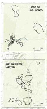
GPS methodology [8]: At San Guillermo National Park in northwestern Argentina 24 adult female Vicuñas (Author’s comment: Vicugna vicugna, not Lama vicugna as incorrectly stated in the title) were collared with GPS radios that transmitted 95,872 location points over two years. Some six statistical programs were used to manipulate the data to examine site fidelity and five programs for home range analysis. Eight females showed no shift in range and results for 18 were inconclusive, but mean short distances indicated (suggested?) no shift (Figure 1). Seasonal core range sizes did not vary significantly across seasons. Although weak yet still statistically significant (n=?, degree of significance?), positive correlations were found between seasonal core range size and family group size (It should be noted that the group size was only measured once in groups where females were immobilized and collared at the beginning of the study, and unrealistically assumed to remain unchanged for 24 months. Not mentioned that at the Pampa Galeras study, Vicuña Family Group size was significantly correlated with feeding territory size (0.76) and total available forage (0.86) in territories, and between forage availability and territory size (0.98) [5].
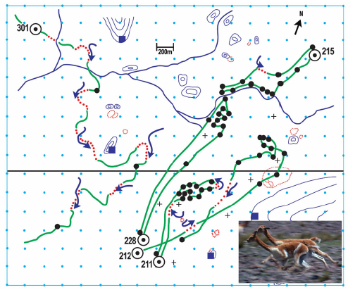
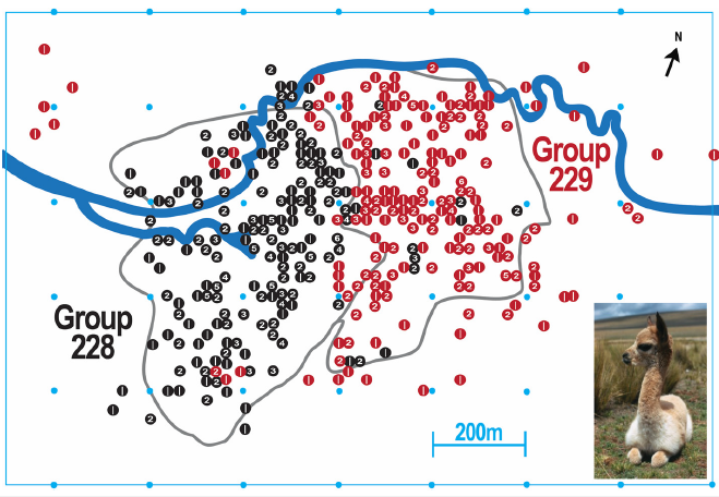
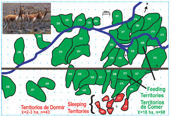
Regarding site fidelity [8]-“Vicuñas demonstrated high site fidelity, in line with previous studies that observed year-round maintenance of territories by vicuña families [5,9,10]. While this is a possibility, the differences in home range size could also result from methodological differences, since estimates from previous studies were based on a visual estimation of movements in the landscape rather than using quantitative home range estimation methods based on systematic data collection over sustained periods of time, as is possible with GPS collar data.” (Note the attached Figures 2-4 the implied inferior results compared to the results obtained by GPS in Figure 1. There is no Franklin 1976, but 1978 [5] is correct. The Franklin study also collected quantitative data using systematic collection techniques over a two-year period). “Studies based on data obtained through visual observations have limitations in terms of obtaining a sufficient number of locations [every 3hr] for determining accurate home ranges.” (The observational study [3,5] collected data once/hr within 20m in a grided study area of 12.4km2 that documented size and shape of 16-20 territories for eight seasons=24 months based upon over 7000 territorial defensive encounters. Also see Figure 4 for sufficient number of locations for determining territory size and shape [5]).
Regarding conspecific tolerance [8] -“In contrast with previous studies, we found considerable evidence for tolerance of conspecifics from different families, especially while foraging [5,9]- most vicuña seasonal core ranges in San Guillermo National Park overlapped with seasonal core ranges of other individuals, with very few exclusive core ranges. This was corroborated by visual observations recorded opportunistically (anecdotally) during the study period that revealed as many as five collared vicuñas from distinct family groups feeding in close proximity to each other on multiple occasions.” (It is not uncommon [5] that adjacent Family Groups graze adjacent close to each other separated by a mutual territorial boundary as narrow as one meter).
Regarding range overlap [8]-“Vicuñas in San Guillermo National Park shared large portions (38.1± 37.38%, ̄x ± SD) of their seasonal core ranges… In each seasonal analysis period, at least three and up to 10 vicuñas shared more than a third of their seasonal core ranges with other vicuñas.” (Although the GPS study was unable to determine if the Vicuñas were territorial, it was implied by the high site fidelity. Note, observation of territorial defense is necessary to document territoriality. While territories remain in the same basic place, they are not static but make minor to major changes in shape and size between seasons that could easily be misinterpreted as overlap, as revealed by the more accurate observational data based upon territorial defense encounters [5]).
Regarding GPS & Visual [8] -“Advances in biologging technologies now allow for more fine-scale, continuous, and comprehensive analysis of animal space use…compared to the limited number of observations possible through visual methods.” (For advances in biologging techniques… compare Figure 1 with Figures 2-4).
Figure 1:GPS Methodology - “Vicuña core ranges in the Llano de los Leones (north) and the San Guillermo Canyon (south) areas in San Guillermo National Park for the duration of the study. No vicuña was observed to move between the two sites during the study period [8].” Each area was ca. 56km2 and duration of the GPS study was two years.

Figure 2:Observational Methodology - Typical daily movements of four selected Vicuña Family Groups (211, 212, 215 & 228) and one Male Group (301) from sunrise (circled dot) to sunset. Blue dots = grided study area, black straight line = road, wandering blue lines = stream, crosses = water springs, blue squares = observation huts, black dots = hourly location, green lines = undisturbed movements, red dashed lines = escape & retreat movements, blue arrows = aggressive movements of attacking- defending territorial male. Pampa Galeras National Vicuña Reserve, Peru. Adapted from [5].

Figure 3:Observational Methodology - Red and black circles (punches) indicate the location and number of hourly observations of two neighboring Vicuña Family Groups plotted at 20m intervals illustrating the small degree of territorial overlap relative to usage, close presence to mutual border, and high degree of site fidelity. Territorial boundaries drawn independently and separately, based upon aggressive encounters between the adjacent males. Spring season, three months of data. Pampa Galeras National Vicuña Reserve, Peru.

Figure 4:Observational Methodology - Size, distribution, and shape of Vicuña feeding and sleeping territories during a one-spring month. Territorial boundaries based upon aggressive interactions between neighboring territorial males. Cupitay Valley, Pampa Galeras National Vicuña Reserve, Peru. See Figure 2 for symbols. Numerical data based upon 24 months. Adapted from [5].

Observational methodology: A grid of 12.4km2 was laid out in the wide Cupitay Valley of Pampa Galeras National Vicuña Reserve (Peru) with rock cairns 1m tall spaced 200m apart in squares each containing 4ha. North-south lines were numbered with cairns in even-numbered rows painted white and odd in yellow [3,5]. Four observation huts were constructed on high vantage points; observation towers were an alternative. Using cairns as reference points it was possible to estimate and record locations on a map to the nearest 20m. Beginning at sunrise two experienced observers made scans left to right across the grided study area once each hour recording information on a map for each Vicuña group (including single individuals): group size and composition, location, and number of adults and crias (<1 year-old) feeding on defined vegetation types.
Details of aggressive territorial defense were recorded throughout the hour on movements of initiator territorial males and recipient groups. Total territorial encounters were categorized by types and used to outline territorial boundaries on a monthly and seasonal basis. Ten to 20 groups were observed daily. Observational field data was collected four to five days a week, totaling 3623 hours of observation during 24-continuous months averaging 134 hours/month. Groups were identified by high site fidelity, size and composition, and individuals with tags or natural markings and defects. Initial grid construction was labor intense but enabled the collection of detailed data by experienced observers.
Discussion
What are the advantages and disadvantages of the two methodologies of researching Vicuña spatial and social ecologiesi. e., close vs. remote data collection, Observational↔GPS?
Labor & time for construction of grid markers↔No/Optional labor & time for capture & tagging-collaring of animals↔Required/ Significant time commitment for fieldwork and logistics↔No/ Systematic collection of data↔Yes/Identifies social group types↔No/Identifies species-social organization↔No/Identifies core areas↔Yes/Defines degree of site fidelity↔Yes/Group daily movements↔Possible /Determines seasonal migration↔Yes/ Documents social group type, size, & composition↔No/Changes in Family Group size & composition↔No/Understanding relationship of group & territory size↔No/ Determines home ranges↔Yes /Determines territoriality↔No/ Territorial defense types↔No/Accurate location, shape, size, and changes of territories↔No/Details of territorial establishment, occupancy, maintenance, duration↔No/Understands when and why home ranges overlap↔No/Potential for understanding intragroup behavior (e.g., territorial male behavioral regulation of Family Group size)↔No /Detects disbanding of territories and fate of females↔No/Documents birthing and season↔No/ Documents mortality↔No/Habitat type use↔Possible/Intragroup individual feeding behavior by vegetation type↔No /Documents impact on Family Group movements by Male Groups↔No/Documents human impact on movements↔No/Documents impact of domestic animals on movements↔No/ Documents impact of weather on movements↔No/Documents impact of potential predators on movements↔No/Documents impact of dry watering sources on movements↔No/Documents seasonal population size and density↔No/Monitors changes in movement, group size, & territory size due to changes in population density↔No/Involves data reduction & statistical analysis↔Yes/Directly experiences Vicuña daily environment, lifestyle, movements, and rhythms↔No
GPS technology does not provide meaningful insight to the complexities, details and subtles of spatial and social ecology of the Andean Vicuña, especially when in-depth understanding is desired. It is highly questionable that the collection of behavioralmovement data for the Vicuña in a natural ecosystem is best served by an indirect-abstract method. Inclusion of radioed territorial males would add useful insight to spatial distribution of Vicuñas. Consideration should be given to combining the two techniques, particularly when random or long-distance movements are anticipated. Long-term observational data combined with statistical and modeling analyses has been applied to the movements and site fidelity of migratory Guanacos (Lama guanicoe), the other wild Camelid of South America [11]. The relatively new technique of GPS is especially applicable to active-nocturnal species, those occupying dense habitats and in extremely rugged-mountainous terrain. However, new is not necessarily better. In this case when data were collected by GPS, the full meaning and significance of Vicuña spatial and social ecology was misleading if not lost, compared to simply observing the animals in real life in open-fully visible habitat. GPS provides animal location (a dot on a map), but the major disadvantage of GPS is no behavioral data (other than movement) is available [12]. That target discussed above with its bullseye-of-truth is highly contingent upon the depth and quality of how the facts are collected. GPS misses widely the bullseye and adds no new-meaningful information to the subject.
GPS produces copious amounts of data. However, understanding movements at fine scales does not necessarily yield greater knowledge nor our ability to understand an animal’s ecology or information for its conservation [13]. A serious side effect of GPS is that it divorces wildlife ecologists from the field. Historically, what has made great field biologists and ecologists? “First and foremost, …their keen skills of observing animals in their native environments cannot be substituted with technology divorced from the knowledge of natural history [13]”. Many questions remain unanswered on the social organization, territoriality, and ecology of the Vicuña, especially the Southern Subspecies. Hopefully future investigations will take into consideration what is the most appropriate technique for achieving meaningful results… and employ systematic observational methodology.
Acknowledgement
Original research was conducted under the auspices of Utah State University (USA) in collaboration with the Peruvian Ministry of Agriculture and its office the General Directory of Forestry and Wildlife. The work was financed through the generosity of the Conservation Foundation, World Wildlife Fund, Peruvian Ministry of Agriculture, and the Ecology Center at Utah State University. Dr. Allen W. Stokes, Dr. Richard G. Miller, Robert A. McDowell, Dr. Carlos F. Ponce, Feliciano Mendoza, and Saturnino Torres Blanco played vital rolls in the success of the project. Ronald J. Sarno made helpful suggestions on the manuscript and Jennifer Taylor updated figures in color. Publication fees covered by Iowa State University Library and Publication Subvention Grants for Open Access Journals. I express gratitude and appreciation to all.
References
- Franklin WL (2011) Family Camelidae (Camels). In: Wilson DE, Mittermeier RA (Eds.), Handbook of the Mammals of the World, Volume 2 Hoofed Mammals, Lynx Ediciones, Barcelona, Spain, pp. 206-246.
- Franklin WL (1982) Biology, ecology, and relationship of man to the South American camelids. In: Mares MA, Genoways HH (Eds.), Mammalian Biology in South America, Volume 6, Pymatuning Laboratory of Ecology-University of Pittsburg, Special Publication Series, Pennsylvania, USA, pp. 457-487.
- Franklin WL (1983) Contrasting socioecologies of South American wild camelids: The vicuña and the guanaco. In: Eisenberg JF, Kleiman DG (Eds.), Advances in the study of mammalian behavior, Special Publication American Society of Mammals, Anchorage, Alaska, USA, pp. 573-629.
- Arzamendia Y, Carbajo AE, Vilá B (2018) Social group dynamics and composition of managed wild vicuñas (Vicugna vicugna vicugna) in Jujuy, Argentina. Journal of Ethology 36: 125-134.
- Franklin WL (1978) Socioecology of the vicuña, Ph.D Dissertation, Utah State University, Logan, Utah, USA, p. 169.
- Franklin WL (2022) Vicuña dung piles for self-orientation. Bulletin of the Ecological Society of America 103(1): e01946.
- Franklin WL (2022) Vicuña dung gardens at the edge of the cryosphere: Comment. Ecology 103(2): e03522.
- Karandikar H, Donadio E, Smith JA, Bidder OR, Middleton AD (2023) Spatial ecology of the Vicuña (Lama vicugna) in a high Andean protected area. Journal of Mammalogy gyad018.
- Franklin WL (1974) The social behavior of the vicuñ In: Geist V, Walther F (Eds.), The Behavior of Ungulates and its Relation to Management. IUCN, Morges, Switzerland, pp. 447-487.
- Bosch PC, Svendsen GE (1987) Behavior of male and female vicuña as it relates to reproductive effort. Journal of Mammalogy 68(2): 425-429.
- Young JK, Franklin WL (2004) Territorial fidelity of male guanacos in the Patagonia of southern Chile. Journal of Mammalogy 85(1): 72-78.
- Emslie K (2014) GPS and WHF tracking collars for wildlife monitoring. Wildlife ACT Conservation and Research, Melkbosstrand, South Africa.
- Hebblewhite M, Haydon DT (2010) Distinguishing technology from biology: A critical review of the use of GPS telemetry data in ecology. Philos Trans R Soc Lond B Biol Sci 365(1550): 2303-2312.
© 2023 © William L Franklin. This is an open access article distributed under the terms of the Creative Commons Attribution License , which permits unrestricted use, distribution, and build upon your work non-commercially.
 a Creative Commons Attribution 4.0 International License. Based on a work at www.crimsonpublishers.com.
Best viewed in


.jpg)


 Editorial Board Registrations
 Submit your Article
 Refer a Friend
 Advertise With Us
.jpg)


.jpg)


.bmp)
.jpg)
.png)
.jpg)


.jpg)


.png)

.png)


.png)


