- Submissions

Full Text
COJ Electronics & Communications
Management of Wastes Using Remote Sensing
Ashok Chopra*
Department of Management & Commerce, Amity University Dubai International Academic City, UAE
*Corresponding author: Ashok Chopra, Department of Management & Commerce, Amity University Dubai International Academic City, Dubai UAE
Submission: August 19, 2023;Published: April 21, 2023

ISSN 2640-9739Volume2 Issue5
Abstract
There is no denying that the unmanageable amount of waste generated every day by humans and its safe disposal poses a threat to the overall environment. Even United Nations’ Agenda Twenty One specific chapters also promote reduction, management, and recycling of both nonhazardous & hazardous waste. On the other hand, there is hardly any particular treaty, Convention other than the Basel and Bamako Convention, by twelve nations of the Organization of African Unity at Mali in January 1991, and came into force in 1998). Alternatively, the international instrument addresses issues related to generating permissible levels and appropriate methods of waste treatment. On the other hand, E.U. is putting its best effort into erecting safe measures focused on thwarting and reducing waste at generation places and promoting recycling at waste production sites. In this regard, the European Commission (Directive 2006/12/E.C.) deals with the proper treatment of hazardous waste, and (Directive 91/698/EEC) is looking into the control of sites at which waste may get lawfully disposed. (Directive 99/31/E.C., ‘the Landfill Directive’) making sure that adverse and ill effects of the environment are protected. These are the three key legislations that vigorously address the sustainable and environmentally safest way of proper recycling and disposal of waste. During the last few decades, the core issue of waste management has taken an alarming situation, especially in the developing world. Urbanization and lifestyle have added fuel to the fire of waste management. The complexity and interest of broad stakeholders have worsened the situation and made choosing an appropriate site a costly and time-consuming exercise for regulators and planners. In such a situation, technology plays a crucial role as an angel. One such technology of Geographic Information System and satellite remote sensing can do wonders for humanity. It facilitates stakeholders to observe, view, question, understand, visualize, regulate, prevent, interpret, and view spatial and non - spatial data in multiple ways. GIS & Satellite imaging usage can reveal patterns, trends, relationships, and insight in reports, charts, images, maps, and processed pictures about the site in consideration and prevention. Zeroing suitable disposal sites should follow strict norms laid down by regulators and guarantee safety to people and the environment. GIS integrates Geographical, Geomorphological, and other parameters with population and other relevant data in selecting suitable disposal. Governments in many advanced and developing economies depend upon space-borne Remote sensing satellite technology to step up efforts to control waste disposal management. Here, satellite technology monitors suspected sites of monitoring illegal waste dumping. Technology has proved its worth, especially for end-of-life vehicles and electric and electronic waste (WEEE).
Keywords: Reduction; Management, Recycling of hazardous, Nonhazardous wastes; Remote sensing; GIS, Multi-criteria evaluation; Overhead imaging; Hyperspectral; Human and ecological exposure; Spectroscopy; Imaging spectroscopy
Introduction
Anthropogenic activity usually results in enormous release, both hazardous and Non- Hazardous release of accidental and Non-accidental (Intentional) waste in our environment. Waste is generated by domestic, mining (both legal and illegal), military, and industrial units resulting in contamination of air, water, land, resulting in harm to both human & our environment’s health. The burst of unplanned industrialization and population growth has resulted in the transitory and ephemeral release of contamination that challenges extinction of many plant, sea, and animal species and moving forward in challenging survival of even human beings [1]. The analysis and reversing of hazardous waste contamination involves various expensive laboratory analysis equipment and analysis, which is also slow and timeconsuming. In this scenario, one cost-effective technology that gains an edge and provides efficient results compared to earlier prevailed methods is Remote Sensing through Satellite images. The cost to society, human beings, and governments because of hazardous material contamination can be massive and beyond imagination. The stigma of contamination also includes poor health of humans and ecology, negative and lower real estate values, besides the massive burden of the extraordinary infrastructure of regulators on overall economic productivity. In the year 2000, “The United States Environmental Protection Agency (USEPA) estimated that complying with hazardous waste regulations cost staggering U.S. businesses nearly $32 billion” [2]. However, one technology that offers superior technology with a low cost, non-contact alternative is remote Sensing using satellite imaging which would benefit society and humankind. This conceptual paper aims to make aware how remote sensing technology can help in the proper Management of Wastes.
Worldwide concerns
At the global level, the transfer of hazardous Material often occurs from rich and industrialized countries to less industrialized and underdeveloped countries, posing severe health hazards for people living there. In 1980 after the adaption of the Superfund Act in the U.S. and implementation of strict environmental measures on hazardous Material has caused black marketing for unregulated transfer and translocation of hazardous Material from the developed and industrialized world to more miniature industrialized world and less developed countries [3] Further unregulated movement from rich and industrialized countries to poor and less developed countries also led to agreements on international treaties like Rotterdam and Basel Conventions in early 1989-90 [4]. Both Rotterdam and Basel Conventions 1998 were clear in their intention to step out and have total stoppage across boundary movement of hazardous material waste. The main objective of the Basel Convention was “environmentally sound management” to protect human health and the environment by minimizing hazardous waste production. Whenever possible and promoting an “integrated life-cycle approach” to hazardous waste management involves advocating institutional framework from the origination of hazardous waste to its ultimate storage, transport, treatment, reuse, recycling, recovery, and final disposal [5]. The following important is to defining Hazardous Waste
Defining Hazardous Waste
Any ignitable material, capable of causing fire or burning, acidic or corrosive, able to harm organisms or corrode steel because of extreme acidic property or alkaline properties, reactive which able to self - explode, produce toxic gases such as sulfide or cyanide, having Material and substances that dangerous and poison to organism and people. [6] Majority of hazardous waste is the byproduct of the industrial manufacturing process, but many waste results from chemicals used in agriculture like pesticides. Agricultural pesticides are popularly known as Non-Point whereas, industrial waste is known as point sources. Waste generated from households like solvents, gasoline, bleach, and batteries is hazardous waste. Waste can also result from the natural process, e.g., heavy concentrations by the anthropogenic process.
Literature Review
Waste needs definitions per (McDougall et al. 2008) is a useless product that does not have value and lacks usefulness. Waste also refers to the byproduct of many industrial & human activity processes. It could be like a physical object like any other object but lacks value and has lost its physical and natural state. As per [7], “Any garbage, refuse, sludge, waste of treatment plants like sewage, water treatment plant, even air pollution control facility, and other discarded Material, including solid, fluid, semi-solid substance agricultural chemicals like pesticide. Come under the definition of waste. The main issue is what are the concerns of the waste? “As per (McDougall et al. 2008) the goal of waste management need to be beyond current and present concerns of environment, and health to be concerned about long sustainability of managing of the waste.” The earlier understanding of concern of waste on the environment had been the rate of restoration of raw Material more than its consumption rate this as per [8], the focus was on eco-efficiency and conservation, whereas, as per [9] earth on which human existence depends upon is facing challenges of ever-increasing pollution and waste causing deterioration of its carrying capacity of humans. The exact impact is extreme weather, flooding, and extinction of many animal species, burning of forests, flooding, droughts, and major catastrophes worldwide. The highest and most prominent United Nations has given immense importance to the environment’s protection, development, and sustainability. Its millennial goal is environmental safety. The Basel Convention of 1989 is a classic example of the same. The Basel Convention explicitly prevented the uncontrolled transport and dumping of hazardous wastes, including illegal dumping in developing nations by companies from developed countries [10] “As per [11], the current waste Management state, especially in the city, is alarming exerting pressure on social and environmental safety. The worse waste management problem combined with multiple environmental challenges such as poverty, rapid population growth, urbanization aggravated the concern of environmental issues at different scales of the world”. It researched those factors like size and income of family members in households impact the production and disposal of wastes [12]. So in order to tackle this waste management problem, all stakeholders, including public health, government, industries, should adequately discharge their duty and obligation to tackle this menace. Currently, countries and economies are depending upon GIS to tackle the problem of waste management. In GIS raw data and satellite pictures are collected and using appropriate application software this data is processed to see changes which have happened in suspected sites and through the process of regulation waste dispersing involved punishment.” GIS has been applicable to land use planning and assessment since the 1980’s [13]. Since the variables in this research are spatial, the appropriate method of data analysis chosen was the Spatial Multi-Criteria Decision Making”. ‘’Spatial multicriteria decision-making method typically involves a set of geographically defined alternatives (events) from which a choice of one or more alternatives concerning a given set of evaluation criteria [14].”
Methodology
This paper is conceptual; thus, it is always a challenge to have the proper framework for writing. This paper thus draws significant contributions from the literature review as part of secondary datathe literature review involved a three-step approach.
Step 1: Identification of right publications and application of right and practical screening of selected publications. The above ensures that only quality publications are selected and included for review. Indeed publications that cover topics like GIS, Multi-Criteria Evaluation; overhead imaging; hyperspectral may not always be the focus of top journals (because of the ever-progressing status of the referred topic). Chosen keywords for literature search/review were selected to cover topics like Reduction, Management, Recycling of Hazardous, Nonhazardous Wastes, Remote Sensing, GIS, Multi- Criteria Evaluation, overhead imaging; hyperspectral; human and ecological exposure; spectroscopy; imaging spectroscopy. Furthermore, relevant papers had to include the term “Satellite or GIS in the title, abstract, or keywords to meet the search criteria. Confined to the above search identified 16 articles were considered relevant for analysis. The citation information, abstracts, and keywords of all articles used an Excel spreadsheet for further analysis.
Step 2: Involved practically relating theoretical screening benchmarks. After the second round of elimination and screening, six articles were retained. Because the focus of the paper is only on, Reduction, Management, Recycling of Hazardous, Nonhazardous Wastes, Remote Sensing; GIS, Multi-Criteria Evaluation; overhead imaging; hyperspectral; human and ecological abstract or experimental studies that had waste management issues characteristics as their primary focus got retained for further analysis. In particular and specifically, all abstracts had undergone prudently, and the full papers retrieved of only those that highlighted Remote Sensing, GIS, Satellite images, and waste management.
Step 3: After final selection and then following the elimination process, along with the process of filtering, referencing, and interviews with stalwarts in the fields in this final stage, all 06 articles that met the inclusion criteria were downloaded and undergone in detail in the final analysis and inclusion of the content. Each article’s existing cited references were helpful as a secondary source of literature review. In addition, two interviews with the subject and research experts in the field were part to identify relevant articles. The same led to the identification of 03 additional articles that were perceived to provide notable contributions to understanding GIS, Satellite Imaging, and waste management. Thus, this systematic literature analysis is based on nine articles.
Main Analysis
The Imaging sensors and analysis methods used for hazardous waste analysis and its subsequent waste management are in Table 1 mentioned as under (Figure 1):
Figure 1:Source: the EPA/Environmental Photographic Interpretation Center (EPIC).
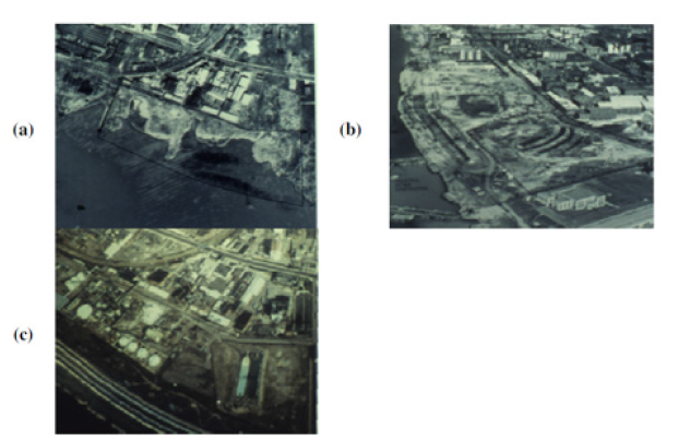
Table 1:The imaging sensors and analysis methods used for hazardous waste analysis.

Remote sensing of hazardous waste
Remote Sensing is related to overhead imaging techniques and includes LiDAR (Light Detection and Ranging), radar X-ray, and acoustic equipment and instruments. Here typically, overhead pictures taken by powerful Satellite cameras are used to record energy in the solar-reflected part of the Electro Magnetic Spectrum (EMS) between 400 and 2,500nm wavelengths [15].
Basic imagery applications
Figure 2:Is an aerial photograph of a drum disposal
site. The photo allows counting and documenting the
number of containers and changes over time.
Source:The EPA/Environmental Photographic
Interpretation Center (EPIC).
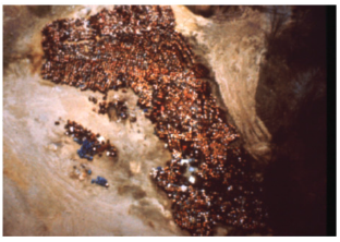
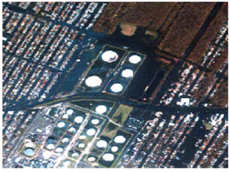
Aerial pictures and photographs used to locate hazardous material and waste disposal sites-aerial photo documentation of structural changes at a hazardous waste site. The simple form of remote sensing data for locating hazardous waste implicates visual interpretation of structural features of production, storage disposal transportation, and its impact on the natural environment. The shoreline filled and expanded outward between 1950 (a) and 1958 (b). An industrial facility including several large petroleum tanks was established by 1964 (c). Images were taken during the ordinary course of action for various purposes, typically capturing the morphological changes on the surfaces that offer detailed pictures about the facilities storing hazardous waste. Satellites take multi-dimensional high-resolution pictures during a routine passing the country sites while in Orbit can detect hazardous Material. If required, satellite images can also be processed using advanced software capable of giving changes in temperature andtoxic gas emissions from the waste of landfills. Such techniques help assess the impact and are in line with compliance issues. Hazardous Material and objects containing them or dumped otherwise when photographed by Satellite become evidence of discarded Material, including barrels Refer (Figure 2) and spills. Objects that are interpreted from aerial photography of sites that contain hazardous waste may include barrels, drums, open dumps, barrels, spills [16] (Figure 3 & 4) and disturbances [17].
Figure 3:A photograph of the deepwater horizon oil spill and failed containment booms in coastal wetlands. Source: U.S. Coast Guard.
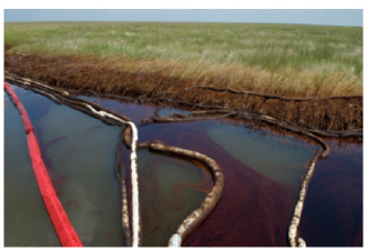
Figure 4:Oil spill from failed containment of a
storage facility during Hurricane Katrina. The spill is
represented by a light blue sheen on the water.
Source:The EPA/Environmental Photographic
Interpretation Center (EPIC).
MS (Multispectral) applications
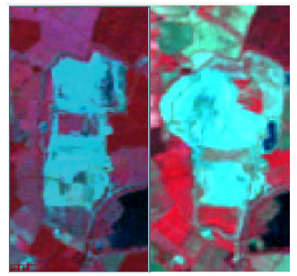
Digitally captures and transmits the emittance energy levels in discrete portions of the EMS, often 4-10 separate bands. Data from multispectral imaging systems such as the Landsat Multi-Spectral Scanner (MSS) and Thematic Mapper (TM) and various aircraftbased systems have been utilized to monitor hazardous waste sites concerning land-use regional risk (Figure 5). These two substances from the Landsat multispectral sensor show the growth of the Brogbouough landfill area in the United Kingdom. The image on the left is from 1992, and on the right, from 200120 [18].
Figure 5:Source: https://www.mdpi.com/2072- 4292/2/11/2474/xml) Visible and Infrared Remote Imaging of Hazardous Waste.
Conclusion
It is clear that Reduction, Management, and further Recycling of Hazardous and Nonhazardous Wastes Using Remote Sensing are safe (Figure 6), less time-consuming, and can help countries and their governments prevent and sustain the planet through the process of regulation [19,20].
Figure 6:Source: Professor Chair Holders of IPB: Three Pillars for Forest Conservation and Sustainability.
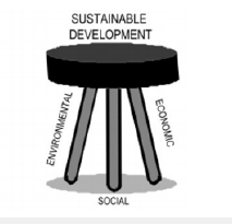
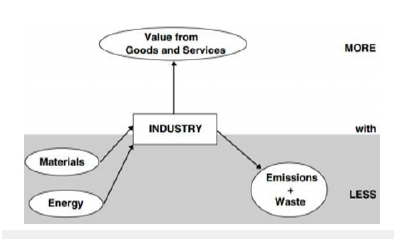
Figure 7:Source: Diagram is a symbolic representation of information using visualization techniques.
Initially, this technique may be expensive as Satellite has to be put in Orbit, but possibilities are endless, reliable, and provide evidence once in Orbit. Remote sensing in the future may open new doors for waste prevention and protect our planet.
References
- Nriagu JO (1994) Arsenic in the Environment: Cycling and Characterization. John Wiley & Sons, Inc: New York, USA, p. 448.
- Sigman, Hazardous H (2000) Toxic Substance Policies. In: Portney PR, Stavins RN (Eds.), Public Policies for Environmental Protection, 2nd (edn), RFF Press Book, Washington, District of Columbia, USA, pp. 215-259.
- Nava C, Worldwide C (1996) Overview of hazardous wastes. Toxicol Ind Health 12: 127-138.
- Kummer K (1992) The international regulation of transboundary traffic in hazardous wastes: The 1989 Basel Convention. Int Comp Law Q41: 530-562.
- UNEP (2006) Introduction to the Basel Convention: United Nations Environmental Program.
- (2010) Resource conservation and recovery act. Code of Federal Regulations, p. 261.
- Chandler AJ, Eighmy TT, Hjelmar, Kosson SE, Sawell J, Vehlow et al. (1997) Municipal solid waste incinerator residues, p. 67.
- Meadows DH, Meadows DL, Randers (1992) Beyond the limits: global collapse or a sustainable future. Earthscan Publications Ltd 68(4): 749-750.
- UNDP (1998) Human Development Report 1998. United Nations Development Program, Oxford University Press, UK.
- Moen AE (2008) Breaking Basel: The elements of the basal convention and its application to toxic ships. Marine Policy 32(6): 1053-1062.
- Ezeah, C, Roberts CL (2012) Analysis of barriers and success factors affecting the adoption of sustainable municipal solid waste management in Nigeria. Journal of environmental management 103: 9-14.
- Scheinberg A (2011) Value-added: Modes of sustainable recycling in the modernization of waste management systems.
- Mu Y (2006) Developing a suitability index for residential land use: A case study in dianchi drainage area (master’s thesis, university of waterloo).
- Shalabi AMA, Mansor SB, Ahmed (2006) GIS-based multicriteria approaches to housing site suitability assessment. In XXIII FIG Congress, Shaping the Change, Munich, Germany, pp. 8-13.
- Lyon JG (1987) Use maps, aerial photographs, and other remote sensor data for practical evaluations of hazardous waste sites Photogramm Eng Remote Sensing 53: 515-519.
- Getz TJ, Randolph JC, Echelberger (1983) Environmental application of aerial reconnaissance to search for open dumps Environ Manage 7: 553-562.
- Herman JD, Waites JE, Ponitz (1994) A temporal and spatial resolution remote sensing study of a Michigan Superfund site Photogram Eng Remote Sensing 60: 1007-1017.
- Ottavianelli G, Hobbs S, Smith (2005) Assessment of hyperspectral and SAR Remote sensing for solid waste landfill management. Proceedings of the 3rd ESA CHRIS/Proba Workshop, Frascati, Italy, p. 8.
- Donald MGT, Brown AL (1984) The land suitability approach to strategic land-use planning in urban fringe areas. Landscape Planning 11(2): 125-150.
- Chopra A (2020) Paradigm shift and challenges in IoT security. IOP Publishing, UK.
© 2023 Ashok Chopra. This is an open access article distributed under the terms of the Creative Commons Attribution License , which permits unrestricted use, distribution, and build upon your work non-commercially.
 a Creative Commons Attribution 4.0 International License. Based on a work at www.crimsonpublishers.com.
Best viewed in


.jpg)


 Editorial Board Registrations
 Submit your Article
 Refer a Friend
 Advertise With Us
.jpg)


.jpg)


.bmp)
.jpg)
.png)
.jpg)


.jpg)


.png)

.png)


.png)


