- Submissions

Full Text
Aspects in Mining & Mineral Science
Remediation of the Chahderaz Groundwater: Ensuring the Salinity Decreasing of the Golgohar Mineral Processing Water
Saeid Maknouni Gilani*
Golgohar Iron Ore and Steel Research Institute (GISRI), Iran
*Corresponding author: Saeid Maknouni Gilani, PhD in Hydrogeology, Golgohar Industrial and Mine Co. and Golgohar Iron Ore and Steel Research Institute (GISRI), Sirjan, Iran
Submission: October 14, 2019;Published: November 15, 2021

ISSN 2578-0255Volume7 Issue5
Abstract
Chahderaz plain aquifer provides 25% of required fresh water of Golgohar mining Industries. The problem of the aquifer is salinity increasing that appears in all 8 wells of the Golgohar mine in the plain since next 20 years. The salinity is enhanced from TDS=800ppm, in 20 years ago, to 5966ppm now. The first reason of the salinity increasing is drought of this region that causes unbalancing between the precipitation and the evaporation rate of the plain. But both quantitative and qualitative groundwater models of the plain illustrate traditional method of flood irrigation in the pistachio fields of the plain can increase 44703ppm the TDS of the aquifer during next century. The models predict if artificial recharge project (Arc Percolation Tank) develops on the plain, the TDS increasing of groundwater would not exceed more than 2693ppm during the same period. This method can recognize as a long-term solution of quality assurance of each groundwater that need to remediation; the reason that made Golgohar Mining and Industrial Company totally accept the cost of implementing this project.
Keywords: Golgohar mine; Arc percolation tank (APT); Remediation; Salinity
Introduction
Groundwater flow in the Chahderaz plain of Kerman province, south of Iran, has special conditions [1,2]. Eight wells of this plain supplies 25% of the Golgohar iron ore industries (96 liter/second). The mine is the largest iron ore in Iran (Figure 1) and has the chain of steel making, from mill production to pig iron. Mining activities of the Golgohar has been started since 2002 [1,2]. There is a developing program in this mine that exceed the water consumption from 13 mega cube meters per year to 60 mega cube meters per year; therefore, ensuring of the quality saving of the water resources and risk manager programs for water supplying in order to guarantee the mineral processing is essential for the company. Groundwater is Extracting and transferring from the wells to the mine site using two 21km transmission pipelines. Groundwater studies for developing of water resources, drainage of mine and other aspects of the mine hydrogeology have begun since 1969. There are 55 piezometric and observation wells in the plain those are concisely monitoring each month. The average water table status of the plain can be illustrated as follows in Figure 2. It shows a 10-year continuous groundwater draw down of the plain. This plain is restricted between the ranges of 372250-344140 the North and 32288480-3198480 the East. It has two alluvial aquifers, those thickness are changes between 20m (in the North-west) to 280m (at the center of the plain). Its area is 659 square kilometers. The general groundwater flow direction of the plain, similar to its runoff direction, is from the South-east to the North-west [1,2]. The destination of the flow path is Kheirabad salt pan in the North-west. The depth of groundwater changes from 5 meter (in the North-west) to more than 200 meters (in the South-east). In addition to eight wells of the mine, there are two other wells belong to farmers in the area. The plain includes two aquifers, freshwater in upper side and saline one in beneath (Figure 3). Interface zone between the two aquifers is gently moving toward the South-east of the plain in last centuries. But salinity from the bottom of the extraction wells of the plain is also rising as an Up-coning phenomenon (Figure 3), which occurs beneath a pumping well and shows a hydrostatic imbalance between saline water and freshwater [3]. The area of the salt pan is 314 square kilometers. The salt pan and its surrounded basins are in the southernmost part of the central desert of Iran. The average long-term precipitation of the plain is 146.1mm. Figure 4 shows the precipitation histogram of the plain.
Figure 1: The study area, a) geological map, b) the location of Golgohar, general iso-potential lines, and the plain boundaries.
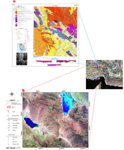
Figure 2: Water table status of the plain.

Figure 3: The up-conning phenomenon in the Chahderaz.
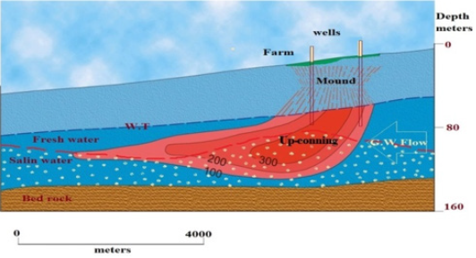
Figure 4: The long-term precipitation histogram of the Chahderaz plain.

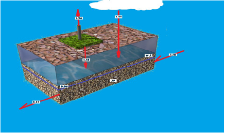
The average evaporation height in the Chahderaz plain is 2850mm/year. The most important reason for the salt pan creation is unbalancing between the precipitation and the evaporation in recent centuries. But it seems irrigation method of the region’s farmers can accelerate salinity. There are more than 1,150 wells around the Kheyrabad plain. Naturally, irrigation method can effect on developing of salinity of the salt pan and its groundwater. Groundwater modeling technique can verify this demand. The agricultural wells of the Chahderaz are like the other 1150 wells of the Kheirabad salt pan. All of farmers of these wells use flood irrigation method in their farms. In this method farmer release water on field until it is sinking few centimeters. Evaporation concentrates the irrigated water and exceeds TDS of surplus water. If it penetrates via field terrain, it will destroy quality of groundwater. To prove this process, the modeling of the Chahderaz groundwater is made. The schematic of the conceptual model of the plain is shown in Figure 5.
Figure 5: The conceptual model of the groundwater of the Chahderaz plain.
Materials and Methods
Groundwater models were applied for remediation of groundwater [4-13]. GSM Groundwater Modeling System) is a powerful device for water modeling and simulating any groundwater [14-16]. The GMS is applied for modeling of the Chahderaz groundwater. Then, the extracted velocity vectors of this model were used as inputs of the MT3DMS (Modular Transport, 3-Dimensional, Multi-Species model) modular model [17,18]. The purpose of this study was to determine trend of future groundwater salinity changes. The period of model was defined one year. Model was run to make a 100-year period prediction of groundwater quality changes. The author supposed these factors during the modeling of the plain and two agricultural wells: the farmers are irrigating their farm 9 times in a year. Discharge rate of the two wells is 50 liters/second (25 litters/second for each). The initial TDS of the well is 5966ppm. The area of their cultivation field is 238 hectares. The evaporation is caused to add 15% of to the salinity of the irrigation water each time, which can penetrate about 1.38 million cubic meters per year from the field into the groundwater. The coefficient of storage, or S, calculates from 0.00012 to 0.00174. The precipitation of the plain is 1.08 million cubic meters per year. The groundwater plain output is 0.7 million cubic meters per year. The groundwater storage decrease is 0.6 million cubic meters per year. The irrigation water is 1.96 million cubic meters per year and the groundwater inputs is 3.58 million cubic meters per year.
Results and Discussion
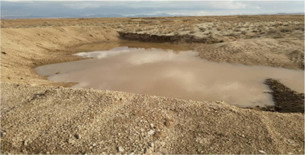
The (Figure 6) respectively shows the result of salinity increasing prediction of the plain groundwater during next century. The continuation of flood irrigation over the next hundred years will cause this environmental disaster. It shows the current groundwater TDS of the plain will increase 44703ppm (from 5966ppm). The effect of evaporation on flood irrigation method is considered by these two wells in this modeling, however, increasing of fertilizers to water irrigation can extra increase the TDS (Figure 6). It seems the effect of other 1,150 wells, which irrigated the Kheirabad salt pan fields during last centuries, is like these wells effect on groundwater. Therefore, this irrigation method has had very destructive effect on salinity increasing and salt pan creation. The future predicting of salinity in groundwater of the plain shows it needs a remediation action. Consequently, an artificial recharge planning in the Chahderaz plain was settled to carry out by the Golgohar Company. The main aim of this project was to remediate the aquifer quality. More than 7000 Arc Percolation Tank (APT) was made on the plain during 2016-2019. The lengths of each APT arc are about 50 meters, and they are made by local soils using eleven loaders. The locations of the APTs were determined by a GIS project. One of them is shown in Figure 7, which is filling after the March 2018 precipitation. A second modeling was developed for simulating the effect of these new APT structures on groundwater quality. The results were fantastic, which are shown in Figure 8. Accordingly, after construction of the APT structures, the maximum increasing of TDS will be only 2659ppm during the next 100 years. Accordingly, the problem of irrational irrigation method of farms can be compensated in a different way. It can be saying the groundwater remediation is happened and started on the plain.
Figure 6: TRespectively shows the result of salinity increasing prediction of the plain groundwater form now to 100 year later. Results of the MT3DMS software.
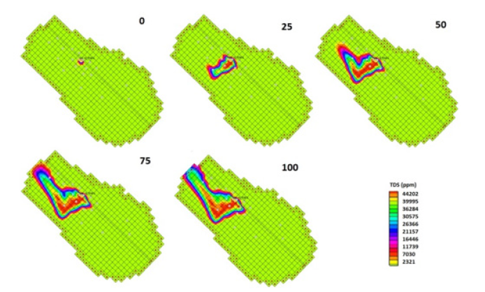
Figure 7: An Arc Percolation Tank (APT) structure in the Chahderaz plain.
Conclusion
a. The quality of the Chahderaz aquifer is at risk in future.
Particularly, the farmers of the plain used to flood irrigation.
This will endanger the water supply of the Golgohar mining
industries.
b. Groundwater flow modeling shows that if no action is
taken in the plain, the TDS of the wells will increase more than
44,000ppm during the next century. Therefore, the aquifer
will not be convenient for the mine industries and the farmers
during next years.
c. More than 7000 APTs have constructed as a simple
method of artificial recharge of the plain.
d. Groundwater modeling by the GSM and the MT3DMS show
these structures can compensate the future TDS increasing.
Thus, the groundwater quality remediation of the plain was
carried out.
e. Flood irrigation can be introduced as another important
factor in salinity increasing and salt pan developing (after
imbalance between evaporation and precipitation).
References
- Maknouni S, Zare M, Raeisei E (2018) Determining the hard rock groundwater pathway in Golgohar complex formation using hydrochemical data in AHP. Arabian Journal of Geosciences.
- Maknouni S, Zare M, Raeisei E (2019) Locating a new drainage well by optimization of a back propagation. Mine Water and the Environment.
- Tarbox DL, Hutchings WC (2001) Topographic influences on the development of freshwater lenses in coastal and island aquifers in lower and middle latitude climatic zones. In: Proceedings of the World Water and Environmental Resources Congress. ASCE, Orlando, Florida, USA.
- Prasad RK, Mathur S (2006) In-Situ bioremediation of contaminated groundwater using artificial neural network. In World Environmental and Water Resource Congress 2006: Examining the Confluence of Environmental and Water Concerns, pp. 1-10.
- Mitra S, Roy P (2011) BTEX: A serious ground-water contaminant. Res J Environ Sci 5: 394-398.
- Mategaonkar M, Eldho TI (2012) Simulation-optimization model for in situ bioremediation of groundwater contamination using mesh-free PCM and PSO. J Hazard Toxic Radioact Waste 16(3): 207-218.
- Kumar D, Mathur S, Panigrahi BK (2013) Hybrid algorithm performance with varying population size for multi-objective optimization of in-situ bioremediation of groundwater. International Journal of Bio-Inspired Computation 5(3): 164-174.
- Sudheer Ch, Kumar D, Prasad RK, Mathur S (2013) Optimal design of an in-situ bioremediation system using support vector machine and particle swarm optimization. J Contam Hydrol 151: 105-116.
- Luo Q, Wu J, Yang Y, Qian J, Wu J (2014) Optimal design of groundwater remediation system using a probabilistic multi-objective fast harmony search algorithm under uncertainty. J Hydrol 519: 3305-3315.
- Griebler C, Avramov M (2015) Groundwater ecosystem services: A review. Freshwater Sci 34(1): 355-367.
- Li J, He L, Chen Y, Song X, Lu H (2016) A bilevel groundwater management model with minimization of stochastic health risks at the leader level and remediation cost at the follower level. Stochastic Environmental Research and Risk Assessment pp. 1-25.
- Ren L, He L, Lu H, Chen Y (2016) Monte Carlo-based interval transformation analysis for multi-criteria decision analysis of groundwater management strategies under uncertain naphthalene concentrations and health risks. Journal of Hydrology 539: 468- 477.
- Raei E, Nikoo MR, Pourshahabi S (2017) A multi objective simulation-optimization model for in situ bioremediation of groundwater contamination: Application of bargaining theory. Journal of Hydrology 551: 407-422.
- Harbaugh AW, Banta ER, Hill MC, McDonald MG (2000) MODFLOW-2000, the US Geological Survey Modular Ground-Water Model: User Guide to Modularization Concepts and the Ground-Water Flow Process. US Geological Survey: Reston, Virginia, USA.
- Perera EDP, Jinno K, Tsutsumi A, Hiroshiro Y (2008) Development and verification of a three-dimensional density dependent solute transport model for seawater intrusion. Memoirs of the Faculty of Engineering, Kyushu University 68: 93-106.
- Mehl SW, Hill MC (2006) MODFLOW-2005 The US geological survey modular ground-water model–documentation of shared node local grid refinement (LGR) and the boundary flow and head (BFH) package.
- Marković T, Brkić Z, Larva O (2013) Using hydrochemical data and modelling to enhance the knowledge of groundwater flow and quality in an alluvial aquifer of Zagreb, Croatia. Sci Total Environ 458: 508-516.
- Rahmawati N, Vuillaume JF, Purnama ILS (2013) Salt intrusion in coastal and lowland areas of Semarang City. Journal of Hydrology 494: 146-159.
© 2021 Saeid Maknouni Gilani. This is an open access article distributed under the terms of the Creative Commons Attribution License , which permits unrestricted use, distribution, and build upon your work non-commercially.
 a Creative Commons Attribution 4.0 International License. Based on a work at www.crimsonpublishers.com.
Best viewed in


.jpg)


 Editorial Board Registrations
 Submit your Article
 Refer a Friend
 Advertise With Us
.jpg)


.jpg)


.bmp)
.jpg)
.png)
.jpg)


.jpg)


.png)

.png)


.png)


