- Submissions

Full Text
Academic Journal of Engineering Studies
Digital Map (GIS based) for Archeological Heritage
Constantin Viorel MARIAN1* and Mihaela IACOB2
1Faculty of Engineering in Foreign Languages, Romania
2Dunărea de Jos University, Romania
*Corresponding author: Constantin Viorel MARIAN, Faculty of Engineering in Foreign Languages, Romania
Submission: October 26, 2021Published: November 22, 2021
.jpg)
ISSN:2694-4421 Volume2 Issue4
Abstract
The paper briefly presents the main product of Arch Terr project “Integrated management of archaeological heritage: archaeological map and administrative procedures for heritage research and protection”; project funded by UEFISCDI following the research collaboration of two scientific centers, “Dunărea de Jos” University of Galați and “Politehnica” University of Bucharest. The scientific research project presents the archaeological heritage digital map with geospatial information (Geographic Information Systems GIS) for Romania. The project was started in 2020 as a winner of multiple (76) research projects competition for cultural national heritage. We present, in the following, one of the deliverables of the project, the archaeological heritage digital map with geospatial information (Geographic Information Systems GIS) for Romania. The digital map was conceived as an essential tool in the activity of protecting the archaeological heritage at the level of each deconcentrated administrative structure (county directorates for culture, county cadaster offices) from the 42 territorial administrative units in Romania; the map is also a means of information for the public. The archaeological map is considered a necessity at European level, in the context of an aggressive investment policy; it comes as a support of heritage protection, cultural (archaeological) but also a land use policy, from the perspective of sustainable development. You can find the fully functional digital map at www.archterr.ro with full open public access.
Keywords: Digital map; Archaeological heritage; GIS
Introduction
The digital map of the archaeological heritage in Romania responds to an urgent need determined by the large infrastructure and real estate projects that are increasingly aggressing the archaeological heritage. International and national awareness of the vulnerability of this category of cultural heritage, which is a non-renewable resource of national identity, has led to the creation of legislative instruments, in parallel with a sustained effort to know this category through complex GIS applications. In order to know, inventory and protect the archaeological heritage, tools for integrated archaeological heritage management have been created in many European countries in the form of an interactive map [1] such as: France [2] (the archaeological map), Italy [3] (the archaeological risk map), Greece [4] (the archaeological cadaster), England [5] (the map of historical heritage), etc. For Romania, the analysis of previous efforts in the field of repertoire of archaeological discoveries RAN (National Archaeological Repertory), eGISPAT (the National Program for Implementing a Geographic Information System for the protection of cultural heritage - archeology and historical monuments) [6] reveled the need for a modern, integrated inventory system of archeological sites and monuments in Romania [7]. For the implementation of the archaeological management, we considered the transfer of technology from informatics, communications, topography, photogrammetry to archaeological heritage. At the same time, three counties were chosen, with different situations depending on the level of knowledge of the archaeological heritage: Constanța, Covasna and Galați.
Discussion
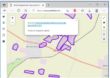
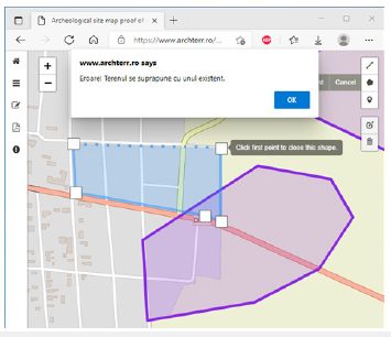
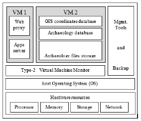
A key feature of the digital map is the simultaneous representation of two different coordinate systems information on the same map. The system permits the conversion between World Geodetic System WGS84 [8] system and Stereo70 [9] system. The data provided in, or the other coordinates are automatically reconverted before representing the polygonal surfaces on the map. The benefit of an automated conversion is avoiding human intervention and this human error when converting Stereo70 to WGS84 and vice versa. Each archeological site is graphically represented and linked to the database using unique identification (Figure 1). If a private investor desires to verify his land position relative to an archeological site, our system is designed to generate the polygonal shape based on the terrain coordinates. This allows immediate checking if the terrain is partially or totally overlapping an archeological site or its archeological protection area. The following figure shows the hardware server implementation. A structure using virtual machines is used for easy future expansion (Figure 2). The server contains in addition to a host operating system and a type 2 hypervisor, all the necessary modules for the management of the entire structure and backup (Figure 3).
Figure 1: Archeological site graphical representation

Figure 2: Error message in case.

Figure 3: Hardware system architecture3

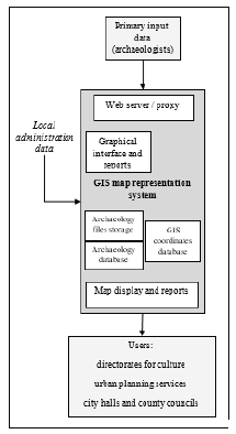
Figure 4: Functional system architecture.

The first virtual machine contains the web proxy server that provides a user friendly interface both for providing archaeological and GIS data and for displaying polygons that represent archaeological sites. It also contains the computer application that analyzes the archeological sites coordinates and displays their positioning on the map as well as the overlap with other terrain surfaces. The second virtual machine is mainly used for storing information. Here we refer with priority to the GIS coordinate information in a database. Archaeological information of any other type is stored in a database and the associated files are saved in the operating system files hierarchy. The typical user are: national directorates for culture; local urban planning services; city halls; county councils administrative services. The following figure presents the functional server architecture (Figure 4).
Conclusion
The paper presented the scientific research project outcome, the archaeological heritage digital map with geospatial information (Geographic Information Systems GIS) for Romania. The fully functional digital map could be found at www.archterr.ro with full open public access.
Acknowledgements
The research project was carried out by “Dunărea de Jos” University Galați (Department of History) and “POLITEHNICA” University Bucharest (Computer Science Department, Faculty of Engineering in Foreign Languages). This work was supported by a grant of the Romanian Ministry of Research and Innovation, CCCDIUEFISCDI, project number PED 571/2020 within PNCDI III.
References
- Calaon D, Pizzinato C (2011) Archaeological analysis in environmental assessment processes. Methodological proposal in GIS environment. Archeology and Calculators 22: 413-439
- The national archaeological map.
- C A R T Archaeological map of territorial risk.
- https://www.arxaiologikoktimatologio.gov.gr/en
- The most important historic places in England are listed.
- Mihai D, Angelescu MV (2009) A centrally managed GIS system for the protection of the archaeological sites and historic monuments. In: Listing archaeological sites, protection for historical landscape, EAC occasional paper nr. 3, Brussels, pp. 109-114.
- Borș C (2014) Protecting the archaeological heritage of Romania. About archeological sites and monuments from the perspective of the evolution of the legislative framework in the European context. Mega Press, Romania, p.146.
- World Geodetic System (WGS84).
- Stereographic 1970 (Stereo70).
© 2021 Constantin Viorel MARIAN. This is an open access article distributed under the terms of the Creative Commons Attribution License , which permits unrestricted use, distribution, and build upon your work non-commercially.
 a Creative Commons Attribution 4.0 International License. Based on a work at www.crimsonpublishers.com.
Best viewed in


.jpg)


 Editorial Board Registrations
 Submit your Article
 Refer a Friend
 Advertise With Us
.jpg)


.jpg)


.bmp)
.jpg)
.png)
.jpg)


.jpg)


.png)

.png)


.png)


