- Submissions

Full Text
Academic Journal of Engineering Studies
Development of Storm Sewer Warning System for Mobile Devices
Zhu BH1, Lin SS2*, Liao YP3 and Zhu KY2
1Stantec Consulting Services lnc, Taiwan Branch, Taiwan
2Chung Yuan Christian University, Taiwan
3Microsoft Corporation, Washington, USA
*Corresponding author: Shiu Shin Lin, Chung Yuan Christian University, Taoyuan, Taiwan
Submission: May 22, 2021 Published: June 14, 2021
.jpg)
ISSN:2694-4421 Volume2 Issue2
Abstract
This research integrates Real-Time Storm Sewer Simulation model (RTSS) and SWMM Parameters Optimization Model (SPOM) to develop a Sewer Warning System For Mobile Devices (MDSWS). The RTSS and SPOM are integrated into a web service to provide online storm sewer simulation and parameter optimization of SWMM. A mobile App is then developed using HTML5, CSS3, JavaScript and PhoneGap technologies. The App can be applied for real-time storm sewer simulation and warning; the simulated results then be shown immediately on Google maps. In this research, Zhunggung, Baoyi and Shijian drainage systems in Taipei city are employed as the case study. The MDSWS receives real-time rainfall data from Central Weather Bureau to simulate storm sewer conditions of the case studies. The simulated results compared with that simulated by Urban Sewer Warning System (USWS) are identical. In addition, the Google map provides user with visual layers, achieves early warning, and reduces flood damage by warning icons, which can show manhole status. Consequently, it is possible to further achieve the realtime warning for storm sewers so as to mitigate the disasters.
Keywords: SWMM; Google maps; App; Storm sewer; Real-time; simulation
Introduction
Taiwan is an island country surrounded by sea, with steep mountains and turbulent
rivers. Its weather is complex and changeable due to the influence of northeast monsoon and
southwest airflow for a long time. The rainfall is mostly in plum rain season and typhoon
season in summer, with the distribution quite uneven in time and space, which is easy to
form rainstorm in an extremely short time. The staggering rainfall is a severe test for the
urban sewer system for the densely populated cities. In addition, the increase in urban
population in recent years has resulted in an increase in impermeable urban areas, a decrease
in infiltration, and a dramatic increase in surface runoff, so that much of the rainfall does
not flow underground but rapidly accumulates in the low-lying areas. Once the rainstorm
comes, the drainage system has no time to discharge, which will increase the possibility of
urban flooding disaster. Therefore, when the rainstorm comes, it is particularly important
that the urban storm sewer system can immediately remove surface runoff and avoid the
occurrence of flooding. If flood discharge and immediate warning can be made before the
occurrence of flooding, it will reduce the loss of people’s property. In order to avoid flooding
disasters, the storm sewer simulation at home and abroad has developed to a quite mature
stage. These models can use the known hydrologic data to obtain the relevant water
management information through the model simulation calculation and analyze the potential
flooded areas. Such models include Hydro-work, MOUSE (Model for Urban Sewers), Water Balance Model (WBM), SLAMM, SWMM and so on [1-5], which are
widely used in sewer simulation calculation. Wherein, the storm
water management model (SWMM) developed by the United
States Environmental Protection Agency is most commonly used
in planning, analysis and design of various drainage systems and
disaster warning assessment [6-9]. When the rainstorm comes, in
order to make the SWMM simulate the urban storm sewer water
management information in real time, Open MI Framework (Open
Modeling Interface) is used to integrate the rainfall runoff and storm
sewer water management module of SWMM, which overcomes the
problems of program language and data format exchange between
modules, etc [10]. The SWMM is integrated by the Open MI to make
the operation concatenation between two models more efficient,
and the model can run automatically as long as real-time observed
rainfall data is input. This technology can overcome the limitation
that the original SWMM needs to simulate the rainfall data of
complete rainfall events as input and improve the disadvantages
of time-consuming and short of real-time operation. A Real-Time
Sewer Simulation (RTSS) model is developed, and an Urban Sewer
Warning System (USWS) is developed in combination with the
Web GIS display technology [6]. It is helpful to carry out the water
management simulation calculation of sewer system directly when
the rainstorm is coming, and get the results of water management
information immediately, which is helpful for the user to analyze
it quickly. USWS provides the real-time storm sewer simulation,
which can be input and operated by opening browser interface
through network connection. However, it is limited that USWS can
only be used by means of desktop computer or notebook computer,
so it is inconvenient to open computer anytime and anywhere,
when it is outdoors. Therefore, a smart mobile device application
(App) is developed for the real-time storm sewer simulation model,
which makes the web service mobile. It is controlled through UI
of the smart mobile device App by wireless network connection,
which makes the operation more flexible and gives play to realtime
simulation. The simulated water management information is
displayed and analyzed through the smart mobile device, so that
the relevant monitoring personnel can know the water level of
storm sewer manholes in the next few hours or the area that may
be flooded immediately, issue real-time warning, take disaster
prevention measures in advance, and reduce the loss of people’s
property.
In order to make the simulation of storm sewer more realtime
and show the function of early warning display function, this
study develops a storm sewer warning system for mobile devices
(MDSWS) which can be operated in a portable way through the
App software on the smart mobile device and can immediately
carry out the real-time storm sewer simulation through wireless
network connection. The results of water management information
are displayed by the smart mobile device to indicate whether the
sewer manholes overflow with graded warning icons and provide
the function of issuing warning in real time, so as to achieve the
purpose of real-time decision-making for disaster prevention.
Real-time Storm Sewer Simulation and Related Integration Technologies
Real-time simulation technology of urban water management models
SWMM is developed by the United States Environmental Protection Agency, mainly aims at the urban drainage problem caused by the increasingly serious urbanization and is widely used in water management analysis and research of urban storm sewer. The water management simulation of urban storm sewer can be mainly divided into two parts, i.e. rainfall runoff simulation and storm sewer water management simulation, to be calculated. The user can directly obtain the water management information of the storm sewer system by directly inputting the real-time rainfall, and perform the SWMM calculation [6,10-12]. This way of obtaining the storm sewer water management information by directly inputting rainfall data is conducive to carry out a series of calculation processes quickly in urban areas when rainstorm comes, and the results of water management calculation information can be obtained in real time.
Structure of urban storm sewer warning system for mobile devices
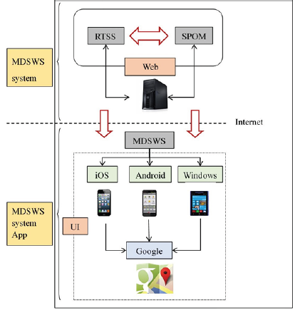
The overall structure of MDSWS is shown in Figure 1, in which a
server platform is used to perform web service, including individual
operation and interconnection operation between RTSS and
SPOM [13]. Both data transmission and calls between models are
completed on this server platform. Messages are delivered through
the Internet and web service, and finally the simulated results are
displayed and analyzed on Google Maps. The overall structure of
MDSWS is roughly divided into two levels, respectively MDSWS
web service and MDSWS App, from platform service to front-end
display operation:
a. MDSWS web service: provide real-time sewer simulation
service, establish network connection through the server
platform, make the real-time sewer simulation service open to
the outside, and establish the calculation and communication of
RTSS and SPOM, which can be dynamically connected with each
other for real-time sewer simulation calculation which can be
started by Internet connection.
b. MDSWS App: with web service and server platform as a
foundation of the whole real-time storm sewer simulation, the
front-end operation interface application (App) is developed
and provides iOS, Android and Windows operating systems
respectively. It carries out real-time storm sewer operation
simulation and data exchange through the smart mobile device
by network connection, displays in the front-end interface,
issues warning and generates graphs to assist decision analysis.
Figure 1: Overall structure of storm sewer warning system.
Development modes of smart mobile device app
Before the development of mobile device interface application
(App), data was collected for the development of mobile device.
It was found that the mobile device brands are very diverse, the
operating systems in use are different, and the development modes
and programming languages are totally different, which increases
difficulty with the development of App application. According to the
current market and most mobile device users, it is found that most
of the operating systems using mobile devices are iOS, Android and
Windows operating systems. If the App for these three operating
systems needs to be developed at one time, most of them use their
own development modes, resulting in a considerable amount of
energy spent on development. Therefore, there are other modes
to develop the App for these three operating systems at one time
recently, and these different development modes are as follows:
a. Native App development: generally, Objective-C, Swift,
Java, C, C++, C# and other programming languages are used
to develop client programs, respectively using their own
development tools. System developers need to understand
these programming languages to develop the App for iOS,
Android and Windows operating systems. It has the advantage
of high support for native operating system, but relatively
improves the development threshold.
b. Web App development: generally,
HTML5+CSS+JavaScript+PHP. /Node.js and other web page
technologies are used to develop client programs, and the
mobile browser on the smart mobile device is used to start
execution. It belongs to a kind of web page. It has the advantage
that it is developed in the same language as the previous Web
page development language that common developers are
familiar with.
c. Hybrid App development: in the same way as Web App
development, software framework tool is compiled with
PhoneGap, allowing the interaction between client program
and mobile device hardware, or some native programs are
added, and finally it is packaged with a Native App shell. It has
the advantage that the development threshold is reduced, the
App which can be used for iOS, Android and Windows operating systems can be developed just by writing a set of programming
codes, which reduces the energy and time in development
progress, but the disadvantage is that some setups and settings
are slightly different or not supported [14-16].
In view of this, this study adopts a hybrid development mode
(Figure 2-5), which only needs to write a set of programming codes
and uses HTML5+CSS3+JavaScript and other web technologies to
develop client application. During the development process, it is
first developed into a Web App and then packaged into a Native
App for iOS, Android and Windows operating systems by using
PhoneGap conversion technology.
Figure 3: Web service architecture of MDSWS.
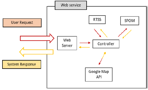
Figure 4: Web service sequence diagram.
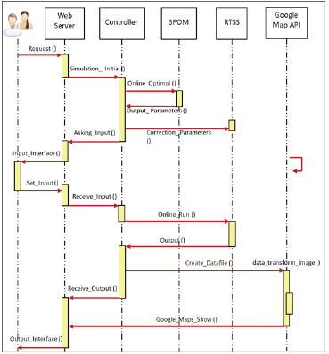
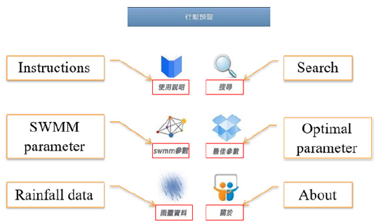
Figure 5: MDSWS app homepage interface.
PhoneGap conversion technology
PhoneGap is to provide a multi-platform App software compiler, using cloud Cordova compiler, and it is unnecessary to use the native SDK for developing at all, or even a Mac computer for compiling iOS App. PhoneGap Build provides free account application, which can create one special App and unlimited shared Apps (https://build. phonegap.com). After the developed HTML5, CSS3 and JavaScript program files and relevant image data are compressed into Zip files and uploaded, it starts generating the App for iOS, Android and Windows operating systems, provides App installation files on the smart mobile device, or downloads directly by scanning 2D barcode with QR code application on the smart mobile device.
Mobile javascript technology
The communication function of MDSWS App developed in this study adopts Ajax of JavaScript technology, which is a technology that can generate asynchronous server requests without reorganizing the web page, without disturbing the user’s actions, changing the browsing history, or losing the global state variables. The conceptual process is shown in Figure 2. In the figure, the user side sends a request to the server side, and the server starts to process and respond after receiving the request, without picture stay or interference with the user in the process. One or more requests sent by the user can be modified asynchronously. Compared with the traditional Web which allows the user side to send a form and send a request to the web server, the server receives and processes the incoming form, and then sends back a new web page, which wastes a lot of bandwidth. Because every time the user side sends a request to the server, it has to wait for the server side to respond to the request before continuing, slowing down the response of the user interface is not good for the MDSWS App in wireless network connection. Using Ajax on MDSWS App can solve the problem of transferring a large number of water management information results generated by the real-time storm sewer simulation, it sends multiple requests to the server side, retrieves the data to be displayed, reduces the data exchanged between the server and App and makes the server respond to the App faster, and it is unnecessary to wait for the server to respond to cause picture stagnation. At the same time, many requests can be sent to complete the real-time simulation on the server, which is very helpful for the real-time simulation and a large number of data transmission of MDSWS.
Development of Urban Storm Sewer Warning System for Mobile Devices
Integrated design of urban storm sewer warning system for mobile devices (Figure 3) shows the web service architecture of MDSWS storm sewer warning simulation system, including the components of web server, controller, RTSS, SPOM, Google Maps API display and so on. The user uses the Internet to make a request to the server. When receiving the request from the user, the web server transmits the relevant information to the controller which can process correspondingly according to the user’s request. For example, when the user wants to perform the storm sewer simulation, the SPOM can calibrate the water management parameters. After that, the controller will call RTSS to start the realtime storm sewer simulation calculation. After calculation, RTSS transmits the storm sewer simulation results to the controller for storing. Then, the controller calls the Google Maps API to analyze the simulation results of water management information. Finally, different colors are marked by warning grading according to the overflow manholes and displayed on Google Maps for early warning display. Figure 4 illustrates the interaction among web service components by the sequence diagram of UML (Unified Modeling Language). In Figure 4, the user side is MDSWS App, and the user side communicates with the web server by Internet Ajax communication technology, wherein, the Online Optimal () function is mainly to initiate SWMM parameter optimization to automatically optimize the water management parameters required inside RTSS online. The controller controls the SPOM to initiate the optimization. After optimization, the Output_ Parameters () function stores the optimal combination, then the Correction Parameters () function calibrates the SWMM core parameters inside RTSS and provides the historical optimal combination parameters in the mobile device for application, so as to quickly calibrate and simulate. After the core calibration of RTSS, relevant settings are input, then the controller calls the Online Run () function to start the RTSS module for simulation, which is considered as the important core of realtime storm sewer simulation. After completion, the simulation is returned to the controller with the Output () function, and also returned to the user side to start the Google Maps API. In the Google Maps API, data transform image () is the function that the Google Maps API transforms text data into graphic data and generates the result information which is used by the Google Maps API for map layer overlapping, and finally the Google Maps Show () function returns the display result.
App design of smart mobile device
The operation homepage UI of the MDSWS App is shown in Figure 5, mainly including the touch buttons of instructions, search function, SWMM parameters, optimal parameter, rainfall data, etc. The overall UI is designed by using the jQuery Mobile program library. Whenever the user presses the button in the interface, the App will send a message to the web server via wireless network and call the RTSS, the SPOM, the Google Maps API and other components by the controller. When the App starts to prepare for simulation, it is mainly divided into two parts for design, namely the real-time storm sewer simulation function and the real-time warning display function. The real-time simulation process starts with the optimal parameter of SWMM parameters.
Result Display of Urban Storm Sewer Warning System for Mobile Devices
Case area introduction
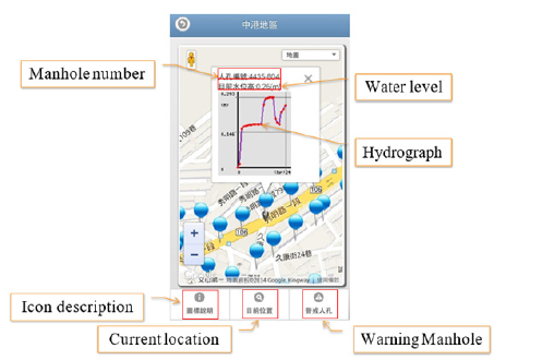
In this study, Zhunggung, Shijian and Baoyi Water Pump Stations in Wenshan District in the fourth drainage area of Taipei City are used as the actual test case area. Zhunggung Water Pump Station is located at the junction of the west side of Zhunggung Water Pump Station system and the Jingmei River. The Station was constructed in 1974, with a catchment area of about 122.4ha. There were originally three pumps with rated pumping capacity of 5CMS and designed pumping capacity of 15CMS. After improvement, a water-pumping set of 12CMS was added, and the current maximum pumping capacity is up to 27CMS. Shijian Water Pump Station undertakes the main line of Zhongshun Street and mainly drains the stormwater from the north side of Zhongshun Street to Muhxin Road, with a total catchment area of 48.0ha and a trunk length of about 2745m. Shijian Water Pump Station is provided with one pump with rated pumping capacity of 2.67CMS and two pumps with rated pumping capacity of 3.00CMS, and the designed pumping capacity of which is 8CMS. The Baoyi Water Pump Station system was redivided into catchment areas in 2000, the region with the catchment area of about 39ha at the upstream section of Sec. 2, Muhxin Rd. 299 lane was classified as the catchment area of Muhsin Water Pump Station. After that, the total catchment area of this area is only 26.6ha. There are two pumps with rated pumping capacity of 2CMS and designed pumping capacity of 4CMS. Changhsin Water Pump Station is provided with two pumps with rated pumping capacity of 1CMS and designed pumping capacity of 2CMS. The users are allowed to input the rainfall data by manual or real-time data (Figure 6a). “Input rainfall data manually” is selected to enter the initial setting interface of system simulation, including the time section length of real-time segmented simulation (Figure 6b, six time lengths of 1hr, 2hr, 4hr, 6hr, 12hr and 24hr available) and pump station drainage systems to be simulated (including Zhunggung, Shijian and Baoyi Water Pump Stations). After the setting is completed, the page will automatically enter the rainfall data input interface (Figure 6c) which assigns appropriate number of cells for rainfall input according to the simulation time length selected by the user. For example, if 12hr is selected as the simulation time length, the system will request the user to input the rainfall data of 1~12hr (input unit: mm). When the start simulation key is pressed, MDSWS will call RTSS for real-time sewer simulation. After the simulation is completed, the whole page of the system will present the numbers and the simulated water level results of each manhole in tabular form (Figure 6d). The users will get a real-time rainfall simulation result output in tabular form if they apply the real-time data (Figure 7). Every situation of the manhole can be shown on the google map, and the user can click the manhole which they want to see how it works. When they click the manhole, there will be a window that shows the manhole number, the water level and the hydrograph (Figure 8).
Figure 6a: Select rainfall input mode.
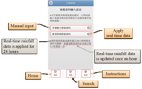
Figure 6b: Input rainfall simulation initial settings manually.
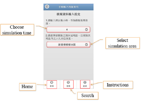
Figure 6c: Input rainfall data manually.
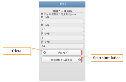
Figure 6d: Input rainfall simulation result output manually.

Figure 7: Real-time rainfall simulation result output.
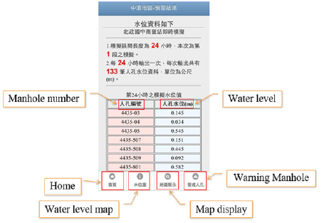
Figure 8: Early warning display on google maps.
Conclusion
This study integrated urban Real-Time Storm Sewer Simulation
Technology (RTSS) and SWMM Parameters Optimization Model
(SPOM) to develop an MDSWS App for real-time warning simulation
on mobile devices, so as to achieve the purpose of real-time
warning and disaster damage reduction in urban water disaster
prevention when rainstorm comes. This study thus developed a
MDSWS, applied parameters through SPOM before simulation, and
provided the set parameters for users to directly input the real-time
rainfall data provided by Central Weather Bureau into the system.
The water depth information of storm sewer manhole could be
obtained after real-time sewer simulation calculation, and warning
simulation analysis and display were carried out on Google Maps
after the simulation. Finally, Zhunggung, Shijian and Baoyi Water
Pump Station systems in the fourth drainage area of Taipei City
were employed as the system test case study. The results of the test
and analysis are as follows:
a. After the actual case test on the water management
calculation model developed by the real-time storm sewer
simulation technology, it is found that the real-time sewer
simulation technology adopts the segmented simulation,
improves the operation efficiency, and can simulate and
complete the result output within a short time, with the realtime
simulation results not much different from those of USWS.
b. In terms of real-time warning display on Google Maps,
after the system actual case test of the system, it is found that
MDSWS can indeed provide the user with humanized visual
layers to understand the results of warning analysis, and Google
Maps is very common and widely used in mobile devices so far
and can correctly display to the user for analysis.
c. MDSWS is an App that provides the mobile device
installation of Android, iOS and Windows operating systems,
and ensures being able to operate and simulate through
network connection (3G, 4G or Wi-Fi), which can effectively
provide outdoor users with urban real-time storm sewer
simulation function and Google Maps warning display function,
so as to achieve the feasibility of urban water warning.
d. In this study, MDSWS is developed with an Open Source
software program. The App for Android, iOS and Window Phone
operating systems is developed in the same language as USWS,
such as HTML, JavaScript, CSS, PHP, etc., which reduces the
difficulty of developing App and facilitates unified maintenance.
In addition, there is almost no additional research cost for
developing the App. Under the threshold of development and
economic consideration, it is really a feasible method.
Acknowledgement
The authors would like to thank the financial support from Ministry of Science and Technology, Taiwan under grant number MOST 108-2625-M-033-001.
References
- Elliott AH, Trowsdale SA (2007) A review of models for low impact urban stormwater drainage. Environmental Modelling & Software, Special section: Advanced Technology for Environmental Modelling 22(3): 394-405.
- Borup M, Grum M, Linde JJ, Mikkelsen PS (2016) Dynamic gauge adjustment of high-resolution X-band radar data for convective rainstorms: Model-based evaluation against measured combined sewer overflow. Journal of Hydrology 539: 687-699.
- Wu W, Yeager KM, Peterson MS, Fulford RS (2015) Neutral models as a way to evaluate the sea level affecting marshes model (SLAMM). Ecological Modelling 303: 55-69.
- Bock AR, Farmer WH, Hay LE (2018) Quantifying uncertainty in simulated streamflow and runoff from a continental-scale monthly water balance model. Advances in Water Resources 122: 166-175.
- Dashti Latif S, Najah Ahmed A, Sherif M, Sefelnasr A, El Shafie A (2020) Reservoir water balance simulation model utilizing machine learning algorithm. Alexandria Engineering Journal 60(1): 1365-1378.
- Tsai WS (2009) Integrating real-time storm sewer simulation and web GIS into urban sewer warning system-A case study of the 4th drainage area in Taipei city. Master Thesis, Chung Yuan Christian University, Taiwan.
- Lowe SA (2010) Sanitary sewer design using EPA storm water management model (SWMM). Computer Applications in Engineering Education 18(2): 203-212.
- Rossman LA (2015) Storm water management model user’s manual version 5.1. U S Environmental Protection Agency, USA.
- Lee JH, Yuk GM, Moon HT, Moon YI (2020) Integrated flood forecasting and warning system against flash rainfall in the small-scaled urban stream. Atmosphere 11(9): 971-989.
- Liao YP, Lin SS, Chou HS (2012) Integration of urban runoff and storm sewer models using the openMI framework. Journal of Hydroinformatics 14(4): 884-901.
- Chagas PF, Souza ROD (2005) Solution of saint venant's equation to study flood in rivers, through numerical methods. Hydrology Days pp. 205-210.
- Horak J, Orlik A, Stromsky J (2008) Web services for distributed and interoperable hydro-information systems. Hydrology and Earth System Sciences 12(2): 635-644.
- Lu SF (2011) Development of the SWMM hydraulic parameters optimization model. Master Thesis, Chung Yuan Christian University, Taiwan.
- Chen HW (2012) The study of cross-platform mobile applications development using phone-gap framework. National Taipei University of Technology, Taiwan.
- Yeh TH (2013) Developing M-commerce platforms in the green industry: An implementation study on phone-gap apps and mobile websites environments. National Chung Hsing University, Taiwan.
- Friberg J (2014) Evaluation of cross-platform development for mobile devices.
© 2021 Lin SS. This is an open access article distributed under the terms of the Creative Commons Attribution License , which permits unrestricted use, distribution, and build upon your work non-commercially.
 a Creative Commons Attribution 4.0 International License. Based on a work at www.crimsonpublishers.com.
Best viewed in


.jpg)


 Editorial Board Registrations
 Submit your Article
 Refer a Friend
 Advertise With Us
.jpg)


.jpg)


.bmp)
.jpg)
.png)
.jpg)


.jpg)


.png)

.png)


.png)


