- Submissions

Full Text
Novel Research in Sciences
Biomonitoring of Littoral Areas of Water Bodies using a Technological Device: A Remote Operated Vehicle (ROV)
Nicola Castelnuovo1, Paola Iotti1, Pietro Scanziani2, Arianna Bellasi2, Ginevra Boldrocchi2 and Roberta Bettinetti2*
1PROTEUS- Center for Environmental Education and Scientific Dissemination, Italy
2University of Insubria, Italy
*Corresponding author:Roberta Bettinetti, University of Insubria, DiSUIT, Via Valleggio, Italy
Submission: June 10, 2021;Published: June 18, 2021
.jpg)
Volume8 Issue1June, 2021
Abstract
Aquatic biomonitoring is an essential task to assess the quality of the environment, using direct information provided by living organisms. In the present study, we described a new biomonitoring using a Remote Operated Vehicle, which allows researchers to observe the littoral aquatic areas with little disturbance to organisms. The technique was applied to a littoral area of Lake Como, Northern Italy, with the aim of evaluating the use of new technological tool to obtain information on the species composition, as well as on the movement patterns of individual fish and benthic organisms during different periods of the year.
Keywords: Dreissena polymorpha; Viviparus sp; Perca fluviatilis; Lucio perca; Quality assessment; Temperature; Movement pattern; Biomonitoring; Remote operated vehicle
Introduction
Biomonitoring consists of observing and assessing the state and ongoing changes in ecosystems, including the natural habitats, populations, and species. In the context of environmental biomonitoring studies, bioindicators are living organisms with specific characteristics, which can be observed or sampled to evaluate risks associated to both the environment and humans [1-3]. Aquatic biomonitoring has become an essential task due to a number of strong anthropogenic pressures which affect the health of lakes, rivers, oceans and groundwater-Aquatic biomonitoring allows to provide information on the quality of ecosystem by recording species diversity and abundances across times, using different ecological and taxonomical information [4,5]. As it become a mandatory task to improve the quality of surface water bodies, governmental commissions, such as the European Commission, have developed standard sampling methodologies [6], on the basis of the current state of knowledge, simplicity and cost. In regard to freshwater bodies, detailed studies have been carried out across Europe for implementing current monitoring and assessment methods [7]; among these methods, one of the most important requires the knowledge of biotic communities of European waters, including composition and biodiversity. In fact, a typical assessment of the environmental quality status, as required not only by the European, but also by the North American and other legislations, relies on matching the composition of organism assemblages, identified using morphological criteria in water ecosystems, to those expected in control environments, in absence of anthropogenic pressures [8]. This is not a simple task to achieve as ecosystems with no impacts are not so widespread. Biomonitoring can be used also as an indispensable tool for studying the environmental exposure to chemicals, including persistent organic pollutants [9-12]. Biomonitoring using mussels, fish or zooplankton -known as early indicators [11,12] can be particularly useful of lipophilic contaminants in the aquatic environment. The concentration in the water column are usually below the analytical detection limit [13], but once bioaccumulated by organisms, they become measurable [11,12]. Therefore bioindicators, when sampled, can be used to evaluate the presence and concentrations of pesticides residues, while abundances of target species or community descriptors are used to assess the ecological condition of ecosystems, but also any possible risk for human health [14]. In this context, the present study aims to increase the current biomonitoring methods, by testing the use of Remote Operated Vehicle (ROV) as a possible tool to increase our knowledge on the species composition analyses and on the movement patterns of individual fish and benthic organisms, during different periods of the year, in a littoral area of a lake
Materials and Methods
The tool
Commercial Remotely Operated Vehicles, known as ROVs, are water drones characterized by low cost, and thanks to these characteristics, the use of ROVs in science has steadily increased in the last years. The model used in the present research is a Trident from Open Rov snc (bought in 2019 by Sofar ocean and now discontinued). Trident is based on Raspberry Pi shield programmed to record a video from a CCD sensor and to manage input from a controller, cabled to the surface with a 100 meters tether. It is also equipped with LED lights (which give about 200 lumens of brightness), thermometer, depth sensor and internal digital compass as support for navigation. An ABS 3d printed shell ensures water pressure resistance up to 100 meters below the surface, and a LiPo battery provides a real autonomy of 3 hours. An Android or an iOS’ device is used to pilot the drone and control application. An Android smartphone (Huawei Psmart) was the main device; a backup was a Samsung Galaxy J3 and an Android Galaxy tab A10 was used to record the observations. It is also possible to use a control pad (i.e. a gaming pad) linked via Bluetooth to enhance the piloting precision. Data, such as depth, temperature, direction and battery life, are visible from the application in real time via On- Screen Display (OSD). The drone was equipped with three brushless motors able to push the Trident up to two meters per second, a reliable speed for its size. The navigation is similar to that of a radio controlled airplane, which uses a single vertical motor to adjust the pitch, allowing the navigation straight up, maintaining high speed. Regarding the cable, a Kevlar reinforced coating provides a tether breaking strength to 100 kilograms.
Methods
The underwater surveys were carried out in Lake Como once a month, for a total of 7 months (April to October 2019), except for July. Major variations in the ecological parameters at both deeper and shallower zones were visually recorded during the study period. Underwater surveys were carried out along transects to reduce the complexity of the route and the risk of entanglement, and thus, assuring repeatability along the same way. Transects in the water column were chosen based on the possible biocenosis presence. To provide a comprehensive comparison of the deeper (with low light) and superficial zone (euphotic), two types of transect were selected:
a. A first Littoral Transect (LT), which crossed the bathymetric profile of the basin for 100m, at a depth within a range of 10- 11m;
b. A second Depth Transect (DT), at the same depth as the first, ran perpendicular for 100m from the littoral area.
Site characteristics
The study site (Punta Geno) is a peninsula extending slightly to the center of the first part of Lake Como basin (Lake Como, Northern Italy), 1km north the city of Como (Figure 1). This site allowed easy access to the lake, and thus, to manage the activities with the drone. Moreover, it borders with two very different underwater environments: the southern part of Punta Geno is characterized by a shallow, flat and homogeneous, fine mud substrate of about 60cm; while the northern part by a steeper littoral profile, which reaches deeper depth up to 120m in the center of the basin. The substrate is made of boulders and pebbles, fading into wall rocks, about 200m north from the site. Considering the ecological differences between the two locations, the LT was placed in the southern area, whereas the DT, crossing the bathymetric profile, was placed in the northern one (Figure 1). Manual piloting used depth and direction as reference, in addition to static underwater objects/natural items. The routes were as simple as possible to avoid difficulties in repeating transects. The first observations were made on April 2nd, 2019, at 6 pm. Execution time was kept as constant as possible for all transects, for better and reliable comparisons. Spatial reference - such as a human structure or recognizable rocks-helps the evaluation of visibility level. The LT had poor visibility, reaching up to 1 meter. The followed direction was 220° North, at a depth of 10-11m. To reach this result, it has been indispensable to avoid an underwater storm drain at about 8 m depth. For the same reason, the transect was limited to 70m. The far side of transect revealed a high number of underwater infrastructures and metal debris.
Figure 1: Bathymetric profile of the investigated area of lake Como. The city of Como closes the basin which has no outlets. Littoral Transect (Lt), Depth Transect (DT) and the start point of observations are highlighted in the area of Punta Geno.
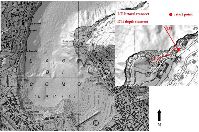
The DT was carried out following the direction of 350° North as reference, for 100m, reaching a maximum depth of 35m. Despite the bathymetric data, the transect revealed deep substrate layer of homogeneous fine mud, the slope was quite relatively steep, decreasing about 35-40cm every meter. The navigation was stopped next to a water outlet, kept as reference for the following observations. The visibility was higher than in the LT, especially below 15m depth, but the light amount decreased to zero, and therefore the drone’s lights was required to record data. Surface level of Lake Como changes depends not only on the seasonal period but also on dam regulation; during drought periods, the level can decrease rapidly by around 1m; this is the reason why the depth of the LT was ±1m (from 10 to 11m below the surface), maintaining the bottom as reference.
Results
Despite the seasonal trend of phytoplanktonic increase, observations carried out in May showed higher visibility than those in April. This is potentially due to a recent heavy rain period, and the consequent release of cold water in the lake. In all visual transects, phytoplankton seems to decrease strongly between 15 and 20m; below this depth, visibility became quite constant, even above the soft substrate, except for mud lifted by fish movements. The observations made in April and August were both characterized by a good visibility; while those in June and November by a decreased visibility, and an increase of phytoplankton biomass was observed. The water transparency is a key factor affecting the behavior of fish populations, their phenotypic divergence in predation by modifying the foraging behavior [15]. Temperature is a key factor in regulating biotic processes in lentic ecosystems; therefore, it was constantly measured using the ROV’s internal thermometer which was calibrated before surveys. During both transects, the temperature remained constant at approximately 20 °C until deeper than 10m. In DT the thermocline was not reached, however the variation in temperature between the shallow (warm) water and the deeper water (cold), indirectly revealed stratification. The lower temperature was measured in April, according to the winter cooling (16.0 °C at the surface, 9.0 °C at 35m with a constant decrease); the highest value in September (24.0 °C at the surface, 11.3 °C at 35m), while in August, the temperature was above 20.0 °C at 10m, as recorded in the LT. The organisms movements allowed for the discrimination of particulate matter from zooplankton; moreover, through the observation of morphological characteristics of zooplankton, such as details of antennae and the shape of the body, it was possible to carry out organisms identification. However, the camera resolution only allowed identification to genus level. The presence of individual benthic macroinvertebrate genera grazing on the substrate along the LT transect was observed using drone imagery. Two fauna associations have been identified: the first belongs to the mollusk species Dreissena polymorpha, strictly bound to the presence of underwater pipe or human structure in general. This bivalve is well adapted to exposed surfaces, and without rocks, human constructions are their preferred substrate. The presence of Dreissena polymorpha was clearly visible several meters below the surface, where valves cover the ground, changing the structure of substrate. The second observed organism was the gastropod Viviparus spp. (Figure 2), probably belonging to the species Viviparus ater, recorded in great abundance in the distal part of littoral transect, at approximately 10m. This mollusk colonizes the substrate, feeding on the organic debris coming from the terrestrial vegetation. The abundance of Viviparus spp. can be related to the morphology of the basin; in fact, although widespread in the basin, this gastropod reaches high densities in correspondence of sub-planar surface, where more accumulation of organic matter is expected. This kind of morphology, and its ecological implication, is rare in Lake Como, typically poor in shallow planar bottom.
Figure 2:Viviparus sp. observed using the drone.
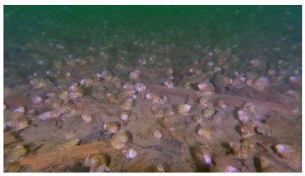
Figure 3: a) A specimen of Sander lucioperca, April; b) Sander lucioperca, LT May; c) School of Perca fluviatilis near the submerged trees at about 15m; d) Perca fluviatilis in shallow water; e) Perca fluviatilis seen in the deeper part of DT; f) A specimen of Perca fluviatilis laying on the bottom (September).
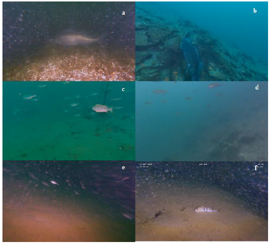
The small size and the speed of the drone seem ideal to follow the fish without scaring them. Indeed, the movement of the drone made some disturbance only when it was very proximal (<1m distance, estimated from comparing average size of adult specimens). The presence, abundance and even behavior of some species, like Perca fluviatilis, Rutilus aula, Sander lucioperca, Salaria fluviatilis, Lota lota, Lepomis gibbosus, Silurus glanis were recorded. During the survey in April, a specimen of Sander lucioperca with bulky abdomen exhibiting an aggressive behavior was recorded (Figure 3a). In May, an additional individual of the same size was recorded while protecting its nest in the surrounding area near the previous observation (Figure 3b). Perca fluviatilis was the most detected species during the survey, evidently due to the low level of disturbance produced by the drone. During May, school of this species was detected between 17 to 27m (DT), in a temperature between 16.0 and 13.0 °C and close to their reproductive habitat (submerged trees) (Figure 3c). In June, at the same bathymetric data (15m DT), no Perca fluviatilis specimens were observed. They were detected just a few meters below the surface (3-4m, Figure 3d) or below 30 meters (Figure 3e). All individuals were adults. In the same survey (May) in the LT a couple of Lepomis gibbosus, adult male and female, were seen in the shallower water. From September to November Perca fluviatilis seemed to become more quiescent at deeper depths as most of the specimens were laying on the bottom (Figure 3f). The surveys also detected the presence of the crustacean Orconectes limosus, an allochthonous crayfish widespread in Lake Como. It was distributed both in the littoral and deeper zone. The macrophyte Potamogetum perfoliatum, Vallisneria spiralis and the green alga Chara globularis were quite rare from 1.5 to 8.0m, and their density was quite low even in LT, probably due to low transparency and kind of substrate rich in fine mud.
Discussion
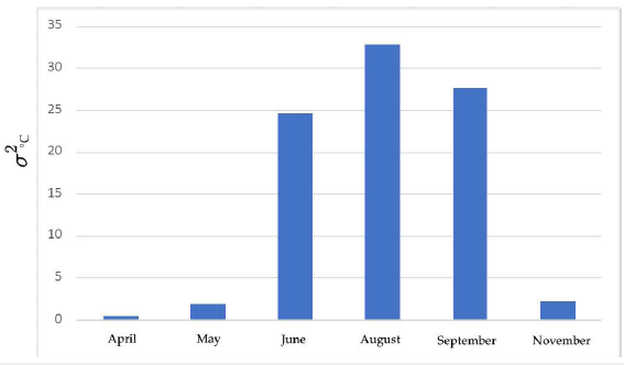
Temperature was measured every 5 meters to evaluate differences between seasons, and to highlight the stratification phenomena of the water column. The data were plotted in relation with depth for each DP (Table 1 & Figure 4). Since data was collected this way, it was possible to distinguish two cluster of curves: the first one represented April, May and November with a quite flat curve, and the second one is steeper for June, August and September, which is correlated to the thermal stratification, with a visible change between 10 and 20m. To enhance the difference of temperature values, variance has been extracted for each DP. As shown in (Figure 5), higher values of variance correspond to a higher difference of temperature at various depth. The novelty of the preliminary results presented here clearly demonstrated that underwater drones represent a valuable tool for monitoring littoral areas (and even pelagic areas) of lakes while creating little to no disturbance, and with a high level of realism. Moreover, the underwater drone provides some advantages to ecological observations, including increased speed and autonomy allowing long record data to depths where it would elsewise require trimix diving researchers, and this would be much more expensive (especially considering continued activities). Videos recorded together with depth, direction and temperature parameters allows to correlate various data like turbidity and depth, algal development with temperature and other parameters. Moreover, the small size and the capability to maintain an accurate depth and direction, as well as the slow impact on fauna as compared for example with a scuba diver, makes the use of ROVs as a new starting point to study fish and benthos abundance, their behavior and population structure dynamics in a more realistic way. Even if no samples can be directly collected, we are quite sure that this will be possible in the future. We are not able to quantify in terms of percentage the novelty of the ROV use within the scientific community, but we are quite sure that a 2-5% improvement in reducing the cost of monitoring of scuba researchers (i.e. protecting their safety) and an equal improvement in the speed of the research itself can be noticeably; increasing times of observations can be important even when weather condition are not optimal to physically dive.
Table 1: Temperature values (°C) and depth (m). N.D. No Data.
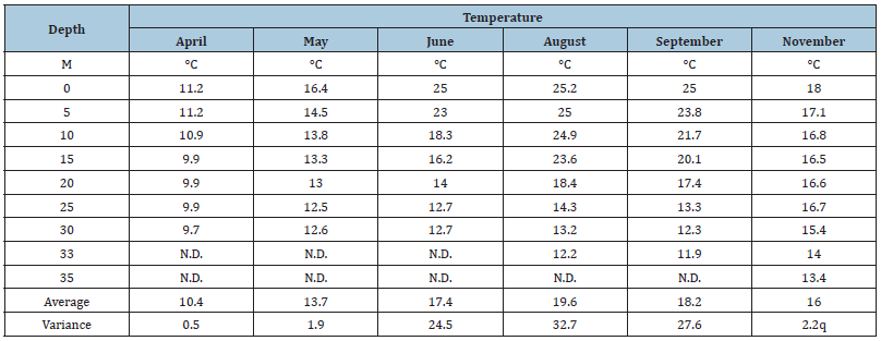
Figure 4:Relation between temperature (°C) and depths (m) of DT during different months.
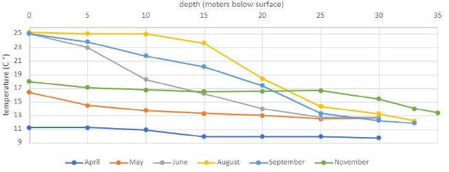
Figure 5:Variance of temperature of the DP in the different months.
There are some limitations to this technology as no GPS is available and the ROV is unable to go deeper and far away from the coast, due to cable length and battery life, alternative strategies have been developed (the use of underwater references, established sampling routes) to overcome these limits. However, tools as drones are in general more open source than commercial ROVs; in particular, the Raspberry Pi shield on which Trident is built has the capability to expand its components, adding plug in or implement function not yet available. Thus, studying water bodies with drones has to be consider only at the beginning stage of its potential.
References
- Abas A (2021) A systematic review on biomonitoring using lichen as the biological indicator: A decade of practices, progress and challenges. Ecol Indic 121.
- Di Maria F, Mastrantonio M, Uccelli R (2021) The life cycle approach for assessing the impact of municipal solid waste incineration on the environment and on human health. Science of the Total Environment 776.
- Shcherbina G, Bezmaternykh V (2019) Effect of Zebra Mussel Dreissena polymorpha (Pallas, 1771) (Mollusca, Dreissenidae) and Perch Perca fluviatilis (L.) (Pisces, Perciidae) of different age groups on the structure and main characteristics of macrozoobenthos in experimental mesocosms. Inl Water Biol 12: 190-198.
- Statzner B, Bady P, Dolédec S, Schöll F (2005) Invertebrate traits for the biomonitoring of large European rivers: An initial assessment of trait patterns in least impacted river reaches. Freshw Biol 50(12): 2136-2161.
- Fornaroli R, Cabrini R, Zaupa S, Bettinetti R, Ciampittiello M, et al. (2016) Quantile regression analysis as a predictive tool for lake macroinvertebrate biodiversity. Ecol Indic 61(2): 728-738.
- Bohan DA, Vacher C, Tamaddoni Nezhad A, Raybould A, Dumbrell AJ, et al. (2017) Next-generation global biomonitoring: Large-scale, automated reconstruction of ecological networks. Trends Ecol Evol 32(7): 477-487.
- Boggero A, Zaupa S, Bettinetti R, Ciampittiello M, Fontaneto D (2020) The benthic quality index to assess water quality of lakes may be affected by confounding environmental features. Water (Switzerland) 12(9).
- Cullen P (1990) Biomonitoring and environmental management. Environ Monit Assess 14(2-3): 107-114.
- Bettinetti R, Ponti B, Quadroni S (2014) An ecotoxicological approach to assess the environmental quality of freshwater basins: A possible implementation of the EU water framework directive? Environ 1: 92-106.
- Bettinetti R, Garibaldi L, Leoni B, Quadroni S, Galassi S (2012) Zooplankton as an early warning system of persistent organic pollutants contamination in a deep lake (lake Iseo, Northern Italy). J Limnol 71(2): 335-338.
- Bettinetti R, Galassi S, Quadroni S, Volta P, Capoccioni F, et al. (2011) Use of anguilla anguilla for biomonitoring persistent organic pollutants (POPs) in brackish and riverine waters in Central and Southern Italy. Water Air Soil Pollut 217: 321-331.
- Bettinetti R, Quadroni S, Galassi S, Bacchetta R, Bonardi L, et al. (2008) Is meltwater from alpine glaciers a secondary DDT source for lakes? Chemosphere 73(7): 1027-1031.
- Barron MG, Nardo C, Yurk JJ (1996) Bioavailability of PCBs in channel catfish exposed to a treated municipal effluent. Environ Technol 17(5): 557-560.
- Galassi S, Bettinetti R, Neri MC, Falandysz J, Kotecka W, et al. (2008) pp′DDE contamination of the blood and diet in central European populations. Sci Total Environ 390(1): 45-52.
- Bartels P, Hirsch PE, Svanbäck R, Eklöv P (2012) Water transparency drives intra-population divergence in eurasian perch (perca fluviatilis). PLoS One 7(8).
© 2021 Roberta Bettinetti. This is an open access article distributed under the terms of the Creative Commons Attribution License , which permits unrestricted use, distribution, and build upon your work non-commercially.
 a Creative Commons Attribution 4.0 International License. Based on a work at www.crimsonpublishers.com.
Best viewed in


.jpg)


 Editorial Board Registrations
 Submit your Article
 Refer a Friend
 Advertise With Us
.jpg)


.jpg)


.bmp)
.jpg)
.png)
.jpg)


.jpg)


.png)

.png)


.png)


