- Submissions

Full Text
Modern Concepts & Developments in Agronomy
Electrical Geophysics for Agronomic Soil Characterization
Aleksei Trubin3, Yuri Manstein2 and Larisa Golovko1*
1Landviser LLC, Houston, TX, USA and Landviser s.r.o., Prague, Czech Rep
2SiberGeo OU, Tallinn, Estonia
1Faculty of Forestry and Wood Sciences, Czech University of Life Sciences in Prague, 16500 Kamycká 129, Suchdol, Prague 6, Czech Republic
*Corresponding author:Larisa Golovko, Landviser LLC, Houston, TX, USA and Landviser s.r.o., Prague, Czech Republic
Submission: June 08, 2022;Published: July 01, 2022

ISSN 2637-7659Volume11 Issue 1
Abstract
Soil properties are often non-uniformly distributed within the fields. The key soil characteristics (moisture, salinity, acidity, texture, total fertility) vary across the field and dictate variable rates of agricultural inputs. Geophysical methods of Electrical Resistivity (ER) or Conductivity (EC) have been used to map soil properties since 1930 in the USA and since 1960 in Europe, as summarized in Allred et al. [1] and Pozdnyakov [2]. Methods of Direct Current (DC) such as four-electrode probe mapping and Vertical Electrical Sounding (VES) provide actual values of ER at multiple depths but slower than methods of Electromagnetic Induction (EMI). However, the depth of penetration and ER values measured with EMI methods varies depending on soil type and field condition. Farm fields were mapped with AEMP-14 in Rostov, Russia and Montrose, IA, USA, in 2021; ER at low frequencies (15-25kHz) correlated with available water at 50-70cm depth. Electrical resistivity at higher frequencies (60kHz) correlated with pH at a 10-20 cm depth. A Methodic of Calibrating EMI (AEMP-14) measurements with DC VES (Land Mapper) at a few locations is proposed to quantify ER values at multiple depths in outlined areas.
Keywords: Vertical electrical sounding; Agronomy; Soil; AEMP-14; Land mapper
Introduction
The combination of soil characteristics is the main factor affecting yields. Soil properties are often distributed unevenly over the field area. This leads to heterogeneous soil characteristics (moisture, salinity, acidity, texture, total fertility) in different parts of the field. The absence of accurate soil maps increases fertilizer application costs and irrigation water consumption, resulting in reduced yields and profits. The first studies on applying resistivity methods to soil moisture measurement are known from the 1930s. In the 1960s, the same methods were increasingly being applied in the USA and Europe to determine the salinity of soils Allred et al. [1].
Work on the electrophysical characterization of soils has been carried out in Russia since the 1990s under Prof. Pozdnyakov of Moscow State University Pozdnyakov [2]. He used the resistivity method and obtained typical VES curves for different soil types. VES is not the best methodology for investigating large areas due to the low measurement speed. Modern geophysical electromagnetic survey equipment can be successfully used for the zoning of agricultural soils.
Material and Methods
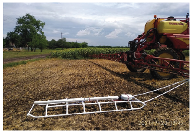
In July 2021, fieldwork was carried out in the Rostov region. AEMP-14 induction electromagnetic frequency sounding equipment was used, mounted on plastic skids 3m long, the height of the device above the ground surface 20cm. The skids were towed by vehicle and tractor, generator of the device forward, the distance from the generator to the tow was not less than 2m (Figure 1).
Figure 1: AEMP-14 on skids.

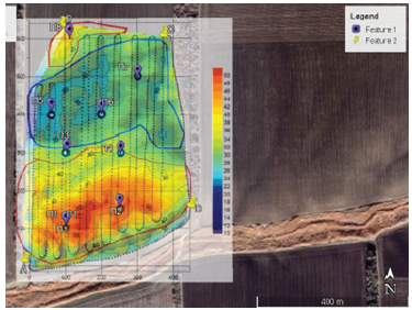
Point datasets with resistivity values were exported with iiSystem (Version 4.04) and plotted on maps in the ArcGIS Pro (Version 2.8) environment, using the Kriging plugin (3D Analyst Tools). As a result of the research, maps of the apparent resistivity distribution were plotted, zoning was carried out, and eight sampling points were identified (Figure 2).
Figure 2:Resistivity map at 61 kHz with sampling points, Rostov region.

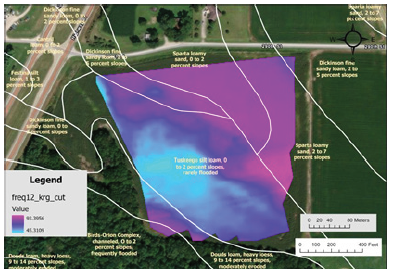
The results of the laboratory tests of the samples were compared with the apparent ground resistivity values. Correlation indices were revealed. It was shown that the moisture content in the soil at a depth of 50-100cm has the most significant influence on ground resistivity at frequencies 9-11kHz, and acidity of the upper part (20-30cm) of the section influences resistivity at frequencies 60-100kHz. Similar studies were carried out in November 2021 in the USA (Montrose, Iowa). A post-harvest cornfield was surveyed using an AEMP-14 on a skid towed by an ATV. A resistivity map with soil map element boundaries is shown in Figure 3.
Figure 3: Apparent resistivity map, Montrose, Iowa.

Results, Interpretation, Conclusion
The data obtained show that the soil characteristics of agricultural soils can be effectively derived from the electrophysical characteristics measured with modern electrical survey equipment.
A limitation of this method is its application to soils with high resistivity. This will cause high deviations between the apparent resistivity calculated from the induction equipment’s signal and the true resistivity values.
Further development of the method, according to the authors, consists of the combination of induction equipment and the Land Mapper portable resistivity method equipment. This technique can be effectively used to measure the resistivity at various spacings, plotting the VES curve. Thus, it is possible to achieve calibration of the apparent resistivity using Land Mapper data by applying it at points selected from induction electromagnetic mapping results.
Acknowledgment
This research and sensor development was supported by EU HORIZON 2020 research and innovation program, PARSEC Consortium, under grant agreement #824478 “Crop Predictions Take Flight – Linking Genomics and Geophysics”.
In addition, geo-analytical services development was supported by grant no. 43950/1312/3128 “Green attack identification with the use of multi and hyperspectral data” financed by Internal Grant Agency FFWS CULS in Prague.
References
- Allred B, Daniels JJ, Ehsani MR (2008) Handbook of Agricultural Geophysics. In: Allred B, Daniels JJ, et al. (Eds.), (1st edn), CRC Press Boca Raton, Florida, USA.
- Pozdnyakov AI (2001) Field electrophysics of soils. Nauka/Interperiodika, Moscow.
© 2022 Larisa Golovko. This is an open access article distributed under the terms of the Creative Commons Attribution License , which permits unrestricted use, distribution, and build upon your work non-commercially.
 a Creative Commons Attribution 4.0 International License. Based on a work at www.crimsonpublishers.com.
Best viewed in


.jpg)


 Editorial Board Registrations
 Submit your Article
 Refer a Friend
 Advertise With Us
.jpg)


.jpg)


.bmp)
.jpg)
.png)
.jpg)


.jpg)


.png)

.png)


.png)


