- Submissions

Full Text
Examines in Marine Biology & Oceanography
Coastal Dynamics in Estuaries and Deltas under the Combined Effects of Large Dams Built Upstream and Rising Sea Levels
Jean Albergel1* and Yadh Zahar2
1University of Montpellier, UMR LISAH, IRD, France
2University of Carthage, VDEC lab, LR01ES20, Tunisia
*Corresponding author: Jean Albergel, UMR LISAH-IRD, 2 Place Pierre Viala - 34060 Montpellier Cedex 1, France
Submission: January 09, 2023;Published: January 23, 2023

ISSN 2578-031X Volume5 Issue3
Abstract
The river streams meet the sea level either by estuaries in which the ocean flows more or less far, or by deltas, large sedimentary constructions reclaimed from the sea. The coastal dynamics of estuaries and deltas is very dependent on the difference in altitude between sea level and the bottom of the riverbed at its mouth, on the sedimentary loading transported by the river at sea, on the erosive force of the tides and on the marine currents. Among these drivers, two are rapidly changing in the Anthropocene: i) The rise of sea level due to climate change or various digging engineering works, ii) The rate of sediment transported by rivers due to the multiplication of large dams or more land husbandry inside the watershed. This review paper recalls the importance of estuaries and deltas, places with high populations due to the port sites they shelter, the richness of the alluvial lands or the importance of mangroves for natural resources and biodiversity. They indicate the principles that drive their formation and evolution. They show from the literature the important changes at the mouths of major rivers during the Anthropocene. Finally, they detail the evolution of the Medjerda Delta in Tunisia, well known since antiquity. Recent studies show the speed of its construction since the Punic period and the even faster reopening of the Gulf of Utica since the construction of large dams, the recent change of land use in the river basin and the rise in sea level. They conclude with a discussion on this global trend of the invasion of estuaries and deltas by the sea.
Keywords:Estuary; Delta; Coastal dynamics; Rise sea level; Large dams; Medjerda river
Abbreviations:RSL: Rise Sea Level ; IPCC: Intergovernmental Panel on Climate Change; SSP: Shared Socio-Economic Pathways replace the so-called ; RCP: Representative Concentration Pathways Scenarios
Introduction
Whether they are deep estuaries largely upwelled by the ocean or inland deltas that have been reclaimed from the sea, the places where river flows and sea level come into contact are hot spots for life and economic activities on our planet. Estuaries and deltas provide protected marine channels where shipping and port facilities have been developed [1] as Shanghai on the Yangtze Delta [2]. New-York/New Jersey harbour on the Hudson River Estuary [3], Port of Hamburg on the Elbe River Estuary [4], Le Havre on La Seine Estuary [5], Ria de Vigo in Spain [6], Sydney Estuary in Australia [7], etc. The deltas are fertile, wetlands where agriculture has developed since ancient times. The Nile Delta, for example, a triangle of just over 100 kilometers on each side between Alexandria, Cairo and Port Said, is home to a third of Egypt’s population and produces half of its agriculture [8]. Vietnam’s fertile Mekong Delta is home to 17 million people and produces half of the country’s agricultural output [9]. In the inter-tropical zone, the circulation of fresh and salt water and the deposition of suspended sediments favour the development of mangrove forests. These are mainly composed of mangrove trees that proliferate on the maritime front of estuaries and deltas, their emerging roots fix the mud and facilitate the landing of the sediment load. They are very important environments for biodiversity and coastal protection and are the subject of competition for their many resources: agricultural, forestry, aquaculture, fisheries, tourism, etc. [10]. The fundamental characteristic of estuaries and deltas is their instability: A slight rise in sea level or a change in the sediment load is enough to radically modify the coastal dynamics. In addition, successive modifications of the river beds can cause the delta to slide from one active zone to another, so that an old part of the delta is destroyed while another is built: There are no less than six juxtaposed or superimposed deltas in the Lower Mississippi complex; the oldest, corresponding to Atchafalaya Bay, is in the process of being reduced, while the most recent, Balize, is progressing towards the sea [11].
The accumulation of considerable masses of sediment at the mouths of large rivers induces a subsidence phenomenon and a deformation of the earth’s crust at the level of the flexure marking the transition from the continental platform to the ocean seafloor. These sediments, which are partly of organic origin, are the source of oil-bearing formations that can be found in many deltas, whether they are fossil deltas transformed into estuaries, such as the Rhine, or active deltas, such as the Niger [12]. Until now, these transformations have taken place over long geological timescales. Dash C (2020) shows, for example, the fluvial response to late quaternary sea level changes in the Mahanadi Delta (India). Both ecosystems and human activities were able to adapt to these transformations. Global changes, (i) Climate change and it’s impact on the rapid rise in sea level, (ii) Large dams and changes in land use in the catchment areas of large rivers with their impact on large rivers discharges and solid transport, are leading to a very rapid coastal dynamic in deltas and estuaries.
Methods and Data to Study Coastal Dynamics in Estuaries and Deltas
The contact between river flows and the marine base level results in the mixing of fresh and salt water and the deposition of sediment brought by the rivers. These river-borne materials can be deposited far out on the continental plateau, but can also be rearranged by waves and marine currents. The transition from fresh to salt water causes the more or less rapid precipitation of dissolved substances. The transition from the marine to the continental environment is never stable: The most powerful rivers or periods of high water push the salt water and sediments out to sea. On the opposite, low flows or low water levels introduce a stratification where the fresh water flowing on the surface overcomes a salt flow which rises more upstream as the flow is low and the slope is small.
In short, the main rules governing coastal dynamics at river
mouths are:
a) The penetration of marine waters into the river bed. This
penetration depends mainly on the difference in altitude
between the sea level and the sea bed.
b) Erosion of the coastline at the river mouth. This depends on
the amplitude and energy of the tides and waves on one hand
and river flows on the other.
c) The supply and deposition of material carried by the river.
The material is in solid or dissolved form. The amount of solid
matter depends on the level of erosion in the catchment area,
whereas dissolved matter depends more on the percolation
of rainfall into the soil. The transport and deposition of solid
particles is due to a combination of gravity acting on the
sediment, and the movement of the fluid in which the sediment
is entrained. The deposition of dissolved matter depends on
the thermo-chemical equilibrium of mixing freshwater and
saltwater.
The low rate of solid transport due to low erosion in the catchment area or because sediment deposition by decanting in lakes, the depth of the river channel which may result from an old glacial valley (Fjord) and the strength of the tidal currents with a high tidal range lead to an estuarine logic. On the other hand, a high rate of solid transport, gently sloping sea-beds on which river alluvial sediments can be deposited and progress towards the open sea, low tidal ranges or even the almost non-existent tides in semi-continental seas such as the Mediterranean, lead to the construction of deltas which are then shaped by coastal currents and waves. It should be noted, however, that many estuaries are obstructed by islands and sandbanks whose bathymetric features reveal the existence of a submerged delta. The case of the Loire Estuary (France) is a good example of this, especially as it is blocked by a «muddy plug» resulting from the combination of both flocculation and anthropogenic discharges. This plug rises and falls with the tide and is only driven out to sea during major floods and is gradually built up again after these floods. The same applies to many other rivers.
Figure 1:Galloway’s ternary diagram, morphodynamic classification of deltas in Brunier G [14].
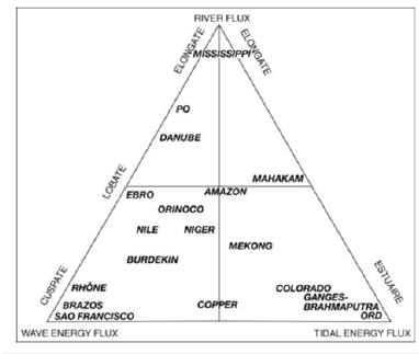
Galloway [13] proposed a ternary diagram to classify the
geomorphological dynamics of deltas and estuaries according to
the influence of fluvial, marine and tidal processes (Figure 1). It has
been used and completed by many authors [14]. Climate change
has consequences on the three mentioned above rules governing
coastal dynamics in estuaries and deltas, resulting in
i) Rising sea levels (melting glaciers and expanding oceans) [15].
ii) Changes in river flows [16].
iii) Changes in vegetation cover with an impact on physical and
chemical erosion flows [17].
(Figure 2) shows the relative sea level since the beginning of the industrial revolution and the start of global warming. The black circles correspond to the Holocene and Athropocene sea level rise (RSL, in m) on the Basque Coast (Spain) reconstituted from Micropalaeontological (benthic foraminifera), sedimentological (grain size) and geochemical (14C, 210Pb and 137Cs radioisotopes and total Pb and Zn) analyses [18]. The black line is the exponential fit, the coloured lines are the exponential relative sea level increase based on the global IPCC projections [19], the blue line represents scenario SSP2-4.5 (intermediate scenario: a level of warming of about 2.7 °C in 2100 compared to the pre-industrial period) and the brown line the scenario SSP5-8.5 (fossil fuel based development scenario: a warming level of about 4.8 °C in 2100 compared to the pre-industrial period). Even if the sea level rise is not the same at all points of the geoid, this figure gives an idea of the protection to be put in place to protect deltas and estuaries [20].
Figure 2:Projected sea level rise on the Basque Coast in Garnier R et al. [20].
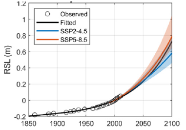
Figure 3:Effect of sea-level rise on Nile Delta populations and farmlands from Simonnett & Sestina 2007; in Duncan M, et al. [21].
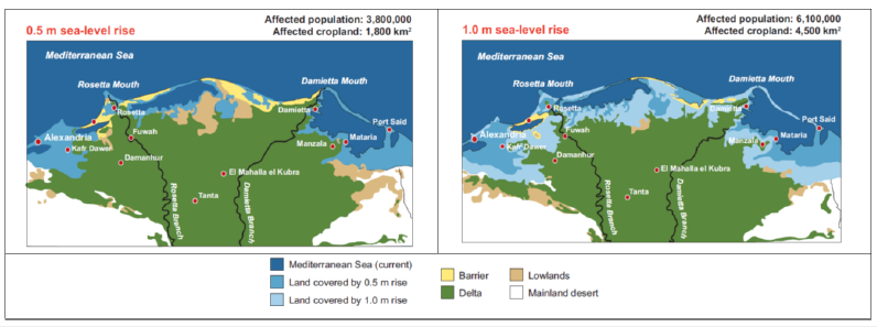
We see a sharp rise in sea level in recent years that will continue to exceed 50cm in the most optimistic assumption in 2100 and reach 1m in a «business as usual» assumption. Protection to prevent a 1m rise in sea level requires very large-scale embankments or a reallocation of living and farming areas. Many large cities on the banks of estuaries or deltas could become uninhabitable if they cannot invest enough to live behind huge seawalls or develop urban planning compatible with rising water levels and recurrent flooding. Among cities most at risk, the IPCC cites Miami, New York, Tokyo, Singapore, Canton, Shanghai, Bombay, Calcutta, Jakarta, Abidjan, Lagos, and many others. The situation will quickly become dramatic in the large deltas, since the rivers have carried a lot of silt over the centuries. These are therefore very fertile, densely populated and extensive areas. The Nile delta will be largely cut off by rising water levels, especially as the dams along its course and especially Lake Nasser at Aswan have been trapping sediment since the second half of the 20th century. Figure 3 shows the loss of agricultural land and the population to be displaced without protection for a rise in the Mediterranean Sea level of 50cm and 1m.
Bangladesh is located on the twin deltas of the Ganges and Brahmaputra rivers. The country, which currently has a population of nearly 150 million and is expected to reach 200 million by 2050, is already regularly subject to catastrophic flooding over more than half its territory. The protection work needed to preserve the population and agricultural land would be titanic. The World Bank considers that a 1m rise in sea level would lead to the submergence of a surface area up to 17,000km² and affect 15 million people [21]. Xiaoxian Chen et al. [22] show that the six mega-dams on the upper Mekong River in China reduce sediment transport by 12.1%, while downstream dams in South-East Asian countries quadruple this reduction (49.7%). However, they show through modelling that a warmer and wetter climate increases erosion and can partially compensate for the loss in sediment supply to the delta. Nevertheless, the delta, which is only one or two meters above sea level, is identified by the World Wildlife Fund as one of the most seriously threatened places on our planet by rising sea levels: “A one-meter rise in sea level could significantly devastate nine critical biodiversity areas, already affected by human activity, in the Mekong Delta” [23]. In addition, the Mekong Delta is experiencing widespread subsidence. Due to massive pumping for drinking water, agriculture and fish and shrimp farms, the delta is sinking by one to four centimeters per year, at a rate three to four times higher than sea level rise. As part of the fight to reduce greenhouse gas emissions, hydroelectric generation capacity is expected to double by 2050 and increase by at least 1,300 gigawatts [24]. These large dams have significant environmental impacts [25] including the sequestration of large amounts of sediment [26,27]. Van de Giesen [28] shows that river damming has reduced sediment fluxes on 1,000 deltas by 50% leading to a loss of 12km²yr-1 of deltaic land.
Cheng HQ et al. [29] analyses morphometric changes in the
Yangtze Estuary from fine bathymetric surveys since 2013 and
highlight three different drivers of these changes:
i) Sediment retention by the three gorges hydroelectric dam,
ii) Engineering interventions in the estuary for navigation
improvement and
iii) Sea level rise due to climate change.
They show erosions and redeposits of sediment in the estuary with new forms including extensive areas of subaqueous dunes in the estuarine channel with maximum turbidity. These morphodynamic transformations result from a combination of an abrupt decrease in sediment supply resulting from the construction of the Three Gorges Dam (TGD) and hydrodynamic changes caused by sea level rise. The latter includes anthropogenic sea level rise due to land subsidence and coastal engineering and estimated between 7-37cm and climate-induced sea level rise of 8cm over the last four decades. Clear evidence of hydrodynamic changes includes also increase in tidal amplitudes. The authors identify an increase of 10-30% in the amplitude of the main tidal component.
A Case Study: The Delta of Medjerda River in Tunisia
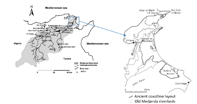
The case of the Medjerda, a river shared between Algeria and Tunisia and ending in a delta in the Mediterranean Sea, is a wellmonitored watershed which, due to its modest size, allows to understand the morphological changes in all their complexity. The long history of human occupation with high quality archaeological remains also provides serious historical references on these coastal dynamics. Medjerda, originates in part of the Atlas Mountains in northeastern Algeria and then flows eastwards to Tunisia, then entering the Gulf of Utica in the Mediterranean Sea. Its course has a length of 460 kilometers. It is the most important and longest river in Tunisia (Figure 4a) [30]. The Gulf of Utica was formed during the postglacial transgression about 6,000 years ago. Over time, fluvial deposits from the Medjerda gradually filled up the northern part of the gulf. The sea gradually withdraw from the northern part during the Middle Ages and modern times. The Ghar el Melh lagoon is the last vestige of what used to be the Utica gulf. Seven river courses with different mouths have been identified since the beginning of the filling of the Gulf of Utica. Following the last big flood in 1973, the Medjerda shifted, once again, its course. It now flows through a canal originally dug to evacuate the overflow of flood waters (Figure 4b) [31]. Since the construction of the dam, there has been a drastic decrease in the volume of water reaching the sea, 8% of the annual inflow evaporates into the lake, and more than 50% is diverted to hydro-agricultural projects.
Figure 4:Map of Medjerda river basin and its delta evolution. 4a. Medjerda River Basin in Zahar Y et al 2008 [30]. 4b. Medjerda Delta in Slim H, et al. [31].
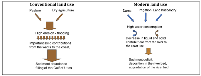
The dam accumulates a part of the sediment transport. It has retained 171 million m3 of sediment since its construction to 2016, which corresponds to a retention rate of 0.86% per year. The dam managers carry out flushing operations to remove these sediments. The solid transport in these flushing operations reaches 60g/l, it is the double of solid transport during floods peaks before the dam (30g/l), but they only allow the removal of 7% of the retained solid contributions during the year. Moreover, the water velocities downstream of the dam, apart from the flushing or spilling, are very low. At the turbine outlet, the water velocity is 0.50m/s. This results in a significant deposit of sediment in the downstream river bed. Deposit which is encouraged by the brushwood of the banks and now rarely reaches the sea shore. More ever, Since the 90s, the Algerian and Tunisian governments have carried out important developments to fight against erosion in the upper basin. All this land management decreases the sediment delivery. Figure 5 shows the impacts of land use on the Medjerda costal dynamics. The conventional land use, pasture and dry agriculture, drive high erosion and high rate of runoff resulting in important sediment contribution carried by strong flow to the sea, then sediment abundance fills the Golf of Utica giving rich farm lands. In a modern land use, dams, irrigation and land husbandry drive to a high water consumption, a decrease of erosion, resulting in a deposition of the sediments in the dams and in the river bed with an aggradation of the banks.
Figure 5:Impact of land use one costal dynamic.
Several archaeological evidences confirm the theory of the present sea level rising compared to the ancient times. In the recent time, sea level is rising, this is confirmed by data from sea level reconstructions since 1870 (red points on Figure 6 established by Marzougui et al. [32] coastal measurements since 1950 (blue points) and by recently launched satellites (black points). The sea level variation curve shows a notable change in the value of the slope. Indeed, before 1930 the slope of the sea level rise is relatively gentle and regular. After 1930, the rate of sea level rise became more pronounced. Sea level over the last 20 years, shows a 25% faster increase compared to the rise during the entire period of the previous 115 years [33]. Satellite data show a linear trend in sea level rise of 3.3±0.4mm/year in recent years while the IPCC predicts a rise of less than 2mm/year [34]. South the river mouth, the coastal dynamics is also very fast with the formation of the lagoon barrier of Ghar El Melh. From different historical documents, aerial photos and google earth images (Figure 7) we describe the evolution of the erosion of the delta, the formation of the sand barrier and the closure of the lagoon. We measured since the implementation of the dam of Sidi Salem that the lagoon cordon is approaching the coast by approximately 100m per year, and has led to dug an opening in its middle in front of the fish landing dock [34].
Figure 6:Annual average sea level showing the current trend in sea level rise (mm) in Marzougui, et al. [32].
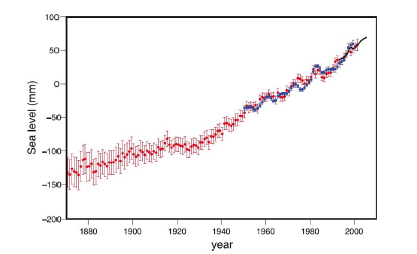
Figure 7:Coastal dynamic at Ghar El Melh lagoon (Medjerda River).
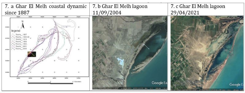
These dynamics of erosion and reshaping of sediments to form temporary lagoons are rapid. In his book «Les cites retrouvées» Georges Hanno [35] proposes a plan of Utica in 46B.C. and shows a port. He indicates that this port exported wheat and olive oil to Rome. Today, the ancient city is located on a promontory in the heart of the Medjerda delta, 10km inland. Pleuger E, et al. [36] confirm from coring in the delta the truth of a position of the promontory of utica overlooking the sea and protecting a port area at Phenician and Roman times. These authors indicate several possible locations for this port.
Discussion
Since the beginning of the Anthropocene [37] and all over the
world, river systems are subject to i) Drastic and rapid land use
changes in their catchment areas, ii) An increase in the number of
large dams on all rivers, and iii) An increase in sea level at their
mouths due to climate change but also due to slight subsidence of
the sediments accumulated since the end of the last ice age and to
over-dams and engineering works to improve waterways. These
changes have a rapid impact on the mouths of small and large
rivers, as Jaia Syvitski et al. [38], a, show in a recent paper where
they explain the formation of deltas. They highlight:
i. “Many Late Holocene deltas have moved from a growth phase
to a sinking phase during the Anthropocene.”
ii. “A mean 76±16% drop in hydraulic energy occurs in all deltas
and drives an ever-decreasing bed-material transport.”
Land use change contributes to global change by altering the relationship between the atmosphere and the land surface, the water cycle and associated material flows. Deforestation, agriculture and urban expansion are the main causes of increased runoff and erosion flows. Soils are progressively being scraped, providing an abundant sediment load. Conversely, land husbandry, reforestation, water and soil conservation schemes increase infiltration flows and protect against water and wind erosion, providing organic matter. The way in which the land use evolves conditions the available sediment at the mouths of the rivers. When the vegetation cover is destroyed and runoff is intense, the rivers are muddy, loaded with clays, sand and iron sediments. These will deposit on the continental plateau and be reshaped by the tides and marine currents. On the other hand, when soils are protected by vegetation, soluble ions (Ca, Na, K, Mg, Si) are leached out under the vegetation cover and carried by the clear rivers to the sea. In contact with the sea, these ions participate in very slow sedimentary formation by chemical precipitation or by biological construction.
Jaia Syvitski et al. [39], recently published in Nature an estimate
of the sedimentary cycle in the Anthropocene, using 1950 as the
reference date, a period when human action accelerated. Their
figures, which they acknowledge to be a first order of magnitude
approximation, give an idea of the scale of the changes at work in
the Anthropocene. The mass flow of sediment linked to humans
exceeds 300 billion tonnes per year. This article proposes the
following issues:
a. Sediment production from soil erosion (deforestation,
agriculture), construction activities, mining, extraction of
all kinds of materials (sand, gravel, aggregates) increased by
about 467% between 1950 and 2010.
b. Sediment consumption in the Anthropocene: Reservoir
sequestration, road and highway development, coal and
concrete consumption, has increased by about 2550% between
1950 and 2010.
c. However, sediment transport from land to the coastal ocean
(via rivers, wind, coastal erosion and ice loss) decreased
by 23% between 1950 and 2010, while riverine particle
transport, including organic carbon, decreased by 49% over
the same period.
95.7% of the total capacity of the world’s reservoirs (>15,000 km3) was built after 1950, and this capacity could double in the next 50 years because of the growing demand for renewable energy and because many more sites for building dams are available, particularly in Africa. It is true that river renaturation projects are beginning to emerge and few dams’ destruction is being carried out or envisaged, but these are old dams and small reservoirs. These very local policies aimed at restoring sediment continuity will have little effect on sediment inputs to estuaries and deltas at a global scale. The mean RSL is now well documented [40]. It is the result of melting ice and the expansion of the volume of the oceans with global warming. The studies cited in this review paper indicate with good reliability that the RSL has already been in the order of 20cm during the 20th century, as shown in Figure 5 extracted from the document by Marzougui et al. [32]. Specialised satellites show that the annual average slope today is more like 3 to 3.5mm, which, if extrapolated linearly, would mean 35cm over the 21st century or, assuming an acceleration, an increase in level that could exceed 0.6m and even reach 1m over the century even if efforts to reduce our emissions of greenhouse gases are not made [41].
There is no single solution to this global trend. Each place is a special case according to physical as well as human geography: New York is built on hard rock, the population is dense and rich. The Ganges delta is immense, land and water are merged, the population is large, but infinitely poor. The Netherlands has undertaken to raise and reinforce its entire dyke system, with an even greater volume of work than that undertaken after the 1956 disaster, but what solution for Bangladesh or Egypt?
Conclusion
The studies mentioned above show that estuaries and deltas are under great threat. The Nile delta may soon be at least partially submerged. Bangladesh, in the Ganges and Brahmaputra deltas, is in danger of being reduced to nothing, its population condemned to massive emigration. The Gulf of Utica could revert to the size of the Punic era when Utica was known as a port. Other deltas and estuaries are also threated as the Niger River delta, the Mississippi delta or the Hudson River, Yellow River, Hudson River’ estuaries. In Europe too, RSL threatens the Rhine delta and impacts the coastal dynamics in the Netherlands; the phenomenon also concerns Antwerp. In France, the entire coastline of the Rhone delta is threatened, with all the coastal or more inland ancient or modern cities. In Italy it is the Po delta. Major consequences are to be expected on the Thames, as well as on the Elbe, the Seine or the Loire, whose estuaries are home to major port facilities. The above findings on the rate of transformation of estuaries and deltas have implications for adaptation strategies to the combined impacts of human activities and climate change. These strategies must consider both the upstream and downstream sides of large rivers and take into account all human interventions, in the catchment area, in the river bed and in the river mouth itself. These effects, which are already tangible, are reflected in increasingly frequent floods, destructive storms and an explosion in compensation by insurance companies, which have to increase their contributions. By 2050, Climate Central, a non-profit research group, estimates that $2.4 billion worth of taxable property will be submerged in Hudson County, New Jersey.
Adaptation measures are i) the relocation of populations and infrastructures to higher places, ii) protection by seawalls in the manner of the Dutch polders, iii) urban planning adapted to frequent flooding like elevating roads, building houses on stilts, iv) natural shorelines to reduce flooding and erosion, v) right-sizing or resizing culverts and bridges, undersized culverts may fail, exacerbating local flooding and increasing infrastructure costs. These adaptation measures require precise monitoring of coastal dynamics and thinking about the management of land use in large rivers estuaries and deltas in terms of sustainable development with all the stakeholders concerned.
References
- Ferreira AMS, Santos CS (2018) Sedimentation and erosion in harbor estuaries. Sedimentation Engineering. IntechOpen Publishers, UK.
- Li W, Wang X (2019) Towards a mega-regional economy: A financial geography perspective to understanding Shanghai’s role in the Yangtze River Delta integration. Geoforum 101: 1-9.
- O’Neil JM, Taillie D, Walsh B, Dennison WC, Bone EK, et al. (2016) New York harbor: Resilience in the face of four centuries of development. Regional Studies in Marine Science 8(2): 274-286.
- Grossman I (2008) Perspectives for Hamburg as a port city in the context of a changing global environment. Geoforum 39(6): 2062-2072.
- Clout H (1975) Le Havre-antifer: A giant channel port. Geoforum 6(3-4): 247-254.
- Lopes C, Antelo LT, Franco-Uría A, Botana C, Alonso AA (2013) Sustainability of port activities within the framework of the fisheries sector: Port of Vigo (NW Spain). Ecological Indicators 30: 45-51.
- Banks J, Hedge LH, Hoisington C, Strain EM, Steinberg PD, et al. (2016) Sydney harbour: Beautiful, diverse, valuable and pressured. Regional Studies in Marine Science 8(2): 353-361.
- Zhao X, Sheisha H, Thomas I, Salem A, Sun Q, et al. (2021) Climate-driven early agricultural origins and development in the Nile Delta, Egypt. Journal of Archaeological Science 136.
- Yamazaki R (2004) Agriculture in the Mekong delta of Vietnam. Louma Productions, France, pp. 1-161.
- Cormier-Salem MC, Panfili J (2016) Mangrove reforestation: Greening or grabbing coastal zones and deltas? Case studies in Senegal. African Journal of Aquatic Science 41(1): 89-98.
- Koninck R (2006) The mississippi delta: Ending the struggle between man and nature. Hérodote 121(2): 19-41.
- Olorunniwo I, Olotu SJ, Alao OA, Adekunle AA (2019) Hydrocarbon reservoir characterization and discrimination using well-logs over “AIB-EX” oil field, Niger Delta. Heliyon 5(5): e01742.
- Galloway WE (1975) Process framework for describing the morphologic and stratigraphic evolution of delta depositional systems. In: Broussard ML (Ed.), Deltas: Models for exploration. Houston Geological Society Houston, USA, pp. 87-98.
- Brunier G (2015) Sandy-muddy coasts under the deltaic influence of the Amazon and the Mekong: morpho-sedimentary dynamics, stability and planning. Thèse Geographie, Aix Marseille University, France.
- Katsman CA, Sterl A, Beersma JJ, Brink HW, Church JA, et al. (2011) Exploring high-end scenarios for local sea level rise to develop flood protection strategies for a low-lying delta-the Netherlands as an example. Climatic Change 109: 617-645.
- Hay LE, Wilby RL, Leavesley GH (2000) A comparison of delta change and downscaled GCM scenarios for three mountainous basins in the United States. Journal of the American Water Resources Association 36(2): 387-397.
- Giri S, Arbab NN, Lathrop RG (2019) Assessing the potential impacts of climate and land use change on water fluxes and sediment transport in a loosely coupled system. Journal of Hydrology 577.
- García-Artola A, Cearreta A, Leorri E (2015) Relative sea-level changes in the Basque coast (northern Spain, Bay of Biscay) during the Holocene and Anthropocene: The Urdaibai estuary case. Quat Int 364: 172-180.
- Fox-Kemper B, Hewitt HT, Xiao C, Aðalgeirsdottir G, Drijfhout SS, et al. (2021) Ocean, cryosphere and sea level change. In: Zhai P, Pirani A, Connors SL, Pean C, Berger S, (Eds.), Climate change 2021: The physical science basis. Contribution of working group i to the sixth assessment report of the intergovernmental panel on climate change. Cambridge University Press, UK, pp. 1-152.
- Garnier R, Townend I, Monge-Ganuzas M, Santiago I, Liria P, et al. (2022) Modelling the morphological response of the Oka estuary (SE Bay of Biscay) to climate change. Estuarine, Coastal and Shelf Science 279.
- FitzGerald DM, Fenster MS, Argow BA, Buynevich IV (2008) Coastal impacts due to sea-level rise. Annual Review of Earth and Planetary Sciences 36(1): 601-647.
- Chen X, Zheng Y, Wang L, Han F, Zeng Z, et al. (2022) Climate change may neutralize the sediment starvation in mega deltas caused by hydropower dams. Sustainable Horizons 4:
- WWF (2020) Living Planet Report 2020.
- IEA (International Energy Agency) (2021) Net zero by 2050: A roadmap for the global energy sector. Paris.
- Best J (2019) Anthropogenic stresses on the world’s big rivers. Nature Geosci 12: 7-21.
- Schmitt RJP, Bizzi S, Castelletti A, Kondolf GM (2018) Improved trade-offs of hydropower and sand connectivity by strategic dam planning in the Mekong. Nat Sustain 1: 96-104.
- Schmitt RJP, Castelletti A, Opperman JJ, Kondolf GM, Bizzi S (2019) Planning dam portfolios for low sediment trapping shows limits for sustainable hydropower in the Mekong. Science Advances 5(10):
- Giesen N (2020) Human activities have changed the shapes of river deltas. Nature 577: 473-474.
- Cheng HQ, Chen W, Li JF, Jiang YH, Hu X, et al. (2022) Morphodynamic changes in the Yangtze Estuary under the impact of the Three Gorges Dam, estuarine engineering interventions and climate-induced sea level rise. Earth and Planetary Science Letters 580.
- Zahar Y, Ghorbel A, Albergel J (2008) Impacts of large dams on downstream flow conditions of rivers: Aggradation and reduction of the Medjerda channel capacity downstream of the Sidi Salem dam (Tunisia). Journal of Hydrology 351(3-4): 318-330.
- Slim H, Trousset P, Paskoff R, Oueslati A (2004) The coast of Tunisia. Geoarchaeological and historical study. Paris: Editions of the National Center for Scientific Research, pp. 1-312.
- Wissem M, Ridha M, Mustapha BHA (2013) Evolution of the Tunisian coastline of Tyrrhenian at present and future forecasts. Annals of Mines and Geology from Tunisia 45: 105-116.
- Oueslati A, Labidi O, Elamri, (2015) Atlas of the vulnerability of the Tunisian coast to sea level rise. Coastal Protection and Planning Agency (APAL), United Nations Development Program (UNDP), pp. 1-67.
- Zahar Y, Guissouma R (2019) Cities and climate change: Risks, impacts, resilience and "no regrets" adaptation measures: Case of the future financial port of the Bay of Tunis. Adaptation to climate change in future cities “Cross-views” ACFAS, pp. 195-220.
- Hanno G (1881) Les villes retrouvée Hachette et C°, Paris, France.
- Pleuger E, Goiran J, Delile H, Gadhoum A, Abichou A, et al. (2019) Exploration of the maritime façade of Utica: The potential location of the Phoenician and Roman harbours. Quaternary International 511: 140-152.
- Crutzen P (2002) Geology of mankind. Nature 415(6867): 23.
- Jaia S, Anthony E, Saito Y, Zăinescu F, Day J, et al. (2022) Large deltas, small deltas: Toward a more rigorous understanding of coastal marine deltas. Global and Planetary Change 218:
- Syvitski J, Ángel JR, Saito Y, Overeem I, Vörösmarty CJ, et al. (2022) Earth’s sediment cycle during the Anthropocene. Nat Rev Earth Environ 3: 179-196.
- Warrick R, Oerlemans J (2018) Reports for climate change: Scientific assessment of climate change. Graphics 9: Sea Level Rise, pp. 1-25.
- Zickfeld K, Solomon S, Gilford DM (2017) Centuries of thermal sea-level rise due to anthropogenic emissions of short-lived greenhouse gases. Proceedings of the National Academy of Sciences 114(4): 657-662.
© 2023 Jean Albergel. This is an open access article distributed under the terms of the Creative Commons Attribution License , which permits unrestricted use, distribution, and build upon your work non-commercially.
 a Creative Commons Attribution 4.0 International License. Based on a work at www.crimsonpublishers.com.
Best viewed in


.jpg)


 Editorial Board Registrations
 Submit your Article
 Refer a Friend
 Advertise With Us
.jpg)


.jpg)


.bmp)
.jpg)
.png)
.jpg)


.jpg)


.png)

.png)


.png)


