
- About Us
- Information
-

The Author ensures that the research has been conducted responsibly and ethically with adherence to all relevant regulations. read more..
- For Authors
- For Reviewer
- Manuscript Guidelines
- Membership
- Publication Ethics
-
- Journals
- Reprints
- e-Books
- Videos
- Policies
- Contact Us
 COVID-19
- Submissions


Full Text
Examines in Marine Biology & Oceanography
Diagnosis on the Seasonal Temperature Changes of the Upper Mixed Layer in the Sulawesi Sea
Xiaofang Wan1, Lu Gao2 and Aijun Pan1*
1Third Institute of Oceanography, Ministry of Natural Resources, China
2Haikou Marine Environment Monitoring Station, State Oceanic Administration, China
*Corresponding author: Aijun Pan, Third Institute of Oceanography, Ministry of Natural Resources, China
Submission: September 18, 2020;Published: September 30, 2020

ISSN 2578-031X Volume3 Issue5
Abstract
Using multiple dataset, including remotely sensed SST, rainfall, surface winds, sea level anomaly and assimilated temperature product, seasonal changes of the upper mixed layer hydrodynamic features are investigated in the Sulawesi Sea. Our results reveal that the Sulawesi Sea maintains a high SST exceeding 28.5°C all-year round and specifically, a cold tongue-like SST pattern emanating from eastern gap between Philippines and Sangihe Islands can be detected in wet season. Further study shows that it is assumed to be a branch of the ITF intrusion under favorable northeast monsoon forcing.
By employing a thermal equilibrium equation, contributions from Surface heat forcing, Ekman advection, Geostrophic advection and Vertical entrainment to the mixed layer temperature tendency are diagnosed quantitatively. It presents that upper mixed layer temperature has drastic seasonality in Sulawesi Sea. As regard to the wet season, Surface heat forcing, Ekman advection and Geostrophic advection all tends to warm the mixed layer during the cooling period (October-January), except the Vertical entrainment, which acts to cool the mixed layer with -0.14°C/monthcooling rate. Comparatively, Surface heat forcing contributes over 79% to the mixed layer warming in the warming phase from February to April. As for the dry season, Ekman advection and Vertical entrainment contributes -0.23°C/monthand -0.25°C/month, respectively, to the mixed layer cooling and largely offsets warming effect induced by Surface heat forcing in the cooling phase of the mixed layer. And for the warming period, again, Surface heat forcing is testified to be a dominant contributor, with 0.27°C/monthwarming effect. Further exploration suggests that impacts from Geostrophic advection on the mixed layer temperature exists throughout the whole calender year, but with relatively subtle contribution.
Keywords:Mixed layer; Surface heat forcing; Ekman advection; Geostrophic advection; Vertical entrainment
Introduction
Figure 1: Configuration and bathymetry of the Sulawesi Sea (m).

Sulawesi Sea is a semi-enclosed basin, surrounded by Philippines, Sulu Archipelago, Kalimantan Island, North Sulawesi and Sangihe Islands. Sulawesi Sea is linked with the Sulu Sea through a narrow channel in the north. And most importantly, Sulawesi Sea acts as a main passage for the Indonesia Througflow (ITF), by connecting the western Pacific ocean with the Java Sea and the Bali Sea through the Makassar Strait (Figure 1).Sulawesi Sea lies at the center of the Indo-Pacific warm pool, where has not only the world's highest Sea Surface Temperature (SST), but also owns the strongest tropical convection and most abundant water vapor Etterson [1]&Vecchi [2]. Moreover, Sulawesi Sea is located at the upstream of the ITF, and the invading waters of the West Pacific significantly changes the local ocean environment. Studies have shown that the western boundary current of the Pacific Ocean consists mainly of the Mindanao Current (MC) from northern hemisphere and the New Guinea Coastal Undercurrent (NGCUC) from southern hemisphere. These two currents meet in the western equatorial Pacific and form a west-oriented branch into the Sulawesi Sea, known as the ITF Sprintall[3]. The ITF is a very important linkage of the global conveyor belt Gordon[4] and which, influences balances of energy and matter, and the global warming “hiatus” through cross-basin thermohaline transport Sprintall [5], Lee [6], Lin [7] &Koch[8].
Given the background of global warming Etterson [1], responses of the upper ocean thermal structure in Sulawesi Sea to monsoon changes, external ITF intrusion, etc., remains unclear. Here, the upper ocean features, for instance, surface winds, rainfall, sea level anomaly, geostrophic current and specifically, the SST are examined in detail. Moreover, diagnostics of the upper mixed layer thermal equilibrium is undertaken to investigate roles played by surface heat forcing, Ekman advection, geostrophic advection and vertical entrainment in regulating the seasonal SST tendency. The paper is organized as follows: Section 2 describes the data used. Introduction of the heat budget equation is given in Section 3. Section 4 presents the results of diagnostic analysis. A conclusion is provided in Section 5.
Data and Methodology
Data
Monthly oceanic data (temperature, salinity) from January 1980 to December 2015 are derived from the Simple Ocean Data Assimilation reanalysis (SODA, 3.4.2), which is developed by the University of Maryland and the Texas A & M University. It has 0.5º×0.5º horizontal resolution and 50 vertical layers. Meanwhile, monthly SST and rainfall data is downloaded from TMI (ftp://ftp2.remss.com/tmi/bmaps_v07.1/), with spatial resolution of 0.25º×0.25º and ranging from 2000 to 2014. Monthly wind field data is obtained from Quick Scat CCMP (http://www.ssmi.com), which is from 1999 to 2008 with same spatial resolution as thatof the TMI dataset.
Besides, monthly heat fluxes from NCEP (http://www.esrl.noaa.gov/psd/data/reanalysis/) during 2000-2014 is adopted, with spatial resolution 1.875º×1.89º. Surface geostrophic current and sea level anomaly data from 2000 to 2014 is downloaded from AVISO (http://www.aviso.oceanobs.com), which has a time frequency of 1 day and spatial accuracy of 0.25º×0.25º.
Thermal equilibrium of the upper mixed layer
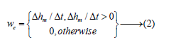
The heat balance equation in the mixed layer is as follows:
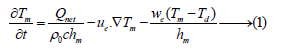
where is the mixed layer temperature, is the net air-sea heat exchange, and cis density and the specific heat, is the mixed layer depth, is the Ekman velocity, which is determined by the wind stressτas , is the entrainment velocity, is the temperature below the mixed layer, and is the geostrophic velocity, which is determined by the sea surface dynamic height as . The five terms in Eq(1) is referred below as the Mixed layer temperature tendency (Tend), Surface heat forcing (Hf), Ekman advection (Ea), Geostrophic advection (Ga) and Vertical entrainment (We), respectively Qiu [9].
Each term in the surface ocean heat budget is obtained from the atmospheric data (winds, heat fluxes) and oceanic data (temperature, salinity) of SODA, whereas the vertical entrainment term is diagnosed by the as follows:
Result
The upper ocean thermal structure of the monsoon domain is largely controlled by the monsoon forcing and the relevant oceanic circulation and therefore, the seasonal variations of the surface winds, rainfall, geostrophic flow and SST fields of the Sulawesi Sea are presented as follows.
Monsoon and rainfall
Figure 2: Monthly wind (unit: m/s) and rainfall (unit: m, shaded) distribution in the Sulawesi Sea a. March, b. June, c. September, d. December

Sulawesi Sea lies between Asia and Australia, surrounded by numerous islands such as the Philippines, Malaysia, the Sulu archipelago and the North Sulawesi. It is also in a typical Asian-Australian monsoon forcing regime Wu[10]. Generally, northeast monsoon prevails from November to April and is usually referred as wet season, whilst southwest monsoon dominates in the period of June-September and which, is called dry season. Meanwhile, May and October acts as the transition period between the dry and wet season. The maximum wind speed is found in January of about 4.9m/s, after that the winds gradually weakens, and the minimum wind speed is detected in May at about 2.9m/s. During the dry season, the southwest monsoon gradually increases, reaching a peak of 4.7m/s in August. Then it weakens andcomes to a minimum of 2.3m/s in November (Figure 2).
Rainfall pattern is largely influenced by the wind blowing orientation and mountains blocking effects. As a result, abundant rainfall is detected in the southern Sulawesi Sea during the wet season and comparatively, the anomalous more precipitation will be found in the northeastern Sulawesi Sea in the dry season. Besides, there is not much precipitation during the monsoon transition period.
Surface geostrophic flow
Figure 3 demonstrates the distribution of the surface geostrophic current and the relevant sea level anomalies. The northern half basin is dominated by anomalous high sea levels and correspondingly, there exists a stable, anticyclonic basin-scale gyre throughout the year. The southern branch of this gyre emanates from the southwestern Philippines, penetrating eventually into the Makassar Strait, and which forms a branch of the ITF Sprintall[3] (Figure 3).
Figure 3: Distribution of the surface geostrophic flow (unit: m/s) and sea level anomaly (unit: m, shaded) in the Sulawesi Sea a. March, b. June, c. September, d. December

Sea Surface Temperature (SST)
Sulawesi Sea maintains a high SST surpassing 28.5°C all-year round. The highest temperature occurrence (above 31°C) is located in the marginal area surrounding the basin, especially in the northeastern basin nearby the Philippines and the southern basin close to the North Sulawesi. Comparatively, relatively low SST is found in the centre of the deep ocean basin. Interestingly, a cold tongue-like SST appearance, emanating from the gap between Philippines and Sangihe Islands westward into the Sulawesi sea, can be detected during the wet season (Figure 4). The westward intrusion of the tongue-like low SST comes from the North Equatorial Current and acts as a branch of the ITF. The intrusion occurs during the wet season and it seems to be driven by the northeast monsoon. Moreover, SST of Sulawesi in dry season is universally higher a bit than that in wet season and specifically, the cold tongue-like SST disappears during the dry season.
Figure 4: Distribution of SST (unit: °C) in Sulawesi Sea a. March, b. June, c. September, d. December

Generally, the anomalous high SST in Sulawesi Sea makes it a natural centre of atmospheric convection and vapor convergence. Hence, how the SST changes and what is the mechanisms responsible for in Sulawesi Sea are great challenges for understanding the warm pool thermodynamics. Since SST is virtually identical to the upper mixed layer temperature, except with 0.5°C or 1°C difference Hanawa[11] &Suga [12], we therefore use temperature of the upper mixed layer as a proxy for SST and explore relevant issues by employing a thermal equilibrium diagnostics as follows.
Thermal equilibrium of the upper mixed layer
Figure 5: Seasonal variations of Temperature tendency (Tend), Surface heat forcing (Hf), Ekman advection (Ea), Geostrophic advection (Ga) and Vertical entrainment (We), respectively.

As is well known, climate of Indonesia is usually divided into dry season and wet season following the seasonal evolution of monsoon. That is, November to April is usually referred as wet season and June to September is called dry season. However, diagnostics on the thermal equilibrium reveals that the upper mixed layer temperature in Sulawesi Sea changes swiftly and has significant seasonal variability (Figure 5).It presents that SST gets warming in February-April and August-September, whilst it cools within June-July and November-January. During the transition period May and October, SST trend is relatively weak in contrast to other seasons. Diagnostics suggests that Surface heat forcing, Ekman advection and vertical entrainment are three dominant factors resulting in the seasonality of the SST changes. And comparatively, contribution from geostrophic advection is quite small throughout the annual cycle (Figure 5).
To be more specific, during the cooling period of the mixed layer (October-January), Surface heat forcing, Ekman advection and Geostrophic advection all acts to warm the mixed layer, except the vertical entrainment which plays a vital role in cooling of the mixed layer with cooling rate of -0.14°C/month. The relative contribution from vertical entrainment to SST trend is estimated up to 35%. Whilst, the warming rate induced by surface heat forcing reaches about 0.21°C/monthand that accounts for 53.16% of the relative contributions. In addition, the cooling trend of the mixed layer reaches its extreme of -0.76°C/monthin December.
Surface heat forcing is the main contributor for the SST warming in February-April, with a relative contribution of 79%. During the warming phase of the mixed layer, Ekman advection also plays a positive role, with relative contribution of 13.49%. Besides, it is noted that warming effect resulted from Ekman advection decreases gradually from February to April, whilst surface heating improves during this period. By comparison, contributions from both geostrophic advection and vertical entrainment are quite small and can be neglected.
As regard to the dry season, the upper mixed layer of Sulawesi experiencestransition from cooling in May-July to warming in August-September. During the cooling phase of the mixed layer, except for the geostrophic advection and surface heat forcing, both Ekman advection and vertical entrainment play important roles in affecting the temperature tendency, where Ekman advection and vertical entrainment contributes -0.23°C/monthand -0.25°C/month, respectively. The cooling impact induced by Ekman advection and vertical entrainment greatly counteracts the warming effect caused by surface heat forcing and as a result, leads to cooling of the upper mixed layer. The relative contribution from Ekman advection and vertical entrainment amounts to 42.19% and 49.37%, respectively. Geostrophic advection is proved to be beneficial for the mixing layer warming, but with minor contribution as only about 2.93%.
As for the warming phase of the mixed layer in August-September, surface heat forcing acts as a main contributor for the warming (0.27°C/month) and largely neutralizes the cooling (-0.35°C/month) induced by the Ekman advection. The warming effect induced by surface heat forcing contributes 44.91% to the temperature increase of mixed layer, in contrast to the cold Ekman advection with 40.34% relative contribution. Meanwhile, geostrophic advection remains as a weak warming advection, with relative contribution of about 8.31%. And by contrast, contribution from vertical entrainment is quite small and negligible.
Next by choosing February, May and August as proxy of wet, transition and dry season, respectively, the spatial features of right-hand terms of the thermal equilibrium of the upper mixed layer is investigated. Though from the viewpoint of region-averaged meaning, surface heat forcing acts to heating the whole basin mixed layer all-year round (Figure 6).
Figure 6: Distribution of Surface heat forcing in February (a), May (b), August (c), (def) is for Vertical entrainment, respectively.

Practically, in given period, for instance, August, it does act to cool the mixed layer in the specific area close to Kalimantan Island (Figure 6c). Besides, surface heating forcing shows a semi-annual cycle, with two peaks in April and October, respectively (Figure 5). Contrary to surface heat forcing, vertical entrainment is merely cooling effect and most importantly, it does not occur throughout the year. As shown from Figure 5, there is no vertical entrainment effect in February, March and August. The spatial map of Figure 6dfverifies it. And when vertical entrainment does happen during the transition period, the strong cooling effect of the mixed layer can be found across the whole basin, especially in the southeastern basin nearby North Sulawesi and Sangihe Islands and western basin close to Kalimantan Island (Figure 6e).
Figure 7: Distribution of Ekman advection in February (a), May (b), August (c), (def) is for Geostrophic advection instead.

Interestingly, unlike the subtle geostrophic advection, Ekman advection plays a crucial role in impacting the seasonal mixed layer temperature changes. And because of the seasonal reversed monsoon forcing, the region-averaged Ekman advection is apparently being divided into cold advection in the dry season (May-October) and warm advection during the wet season (November-April) (Figure 5). Moreover, both of the Ekman advection and Geostrophic advection have apparent seasonality in spatial distribution. Specifically, In wet season (February) most of the Sulawesi basin is with warming Ekman advection, except for the west off Philippines and western basin close to Kalimantan Island (Figure 7). Whilst cooling Ekman advection dominates the northern Sulawesi and warming Ekman advection is confined within the southern basin nearby North Sulawesi in dry season (August) (Figure 7c). By contrast, weak warming Ekman advection occupies the central basin with cold Ekman advection takes over the southern and northern marginal basin during the transition period (May) (Figure 7b).
As mentioned previously, a southwestern flowing current, well-known as ITF Sprintall[3], takes over the upper ocean of Sulawesi sea and penetrates eventually into the Makassar Strait throughout the calendar year (Figure3). Indeed, impacts from Geostrophic advection on the upper mixed layer temperature exists all-year round, only with relatively subtle contribution (Figure 5). In particular, Geostrophic advection does not follow the monsoon changes as that of the Ekman advection. Diagnostics reveals that Geostrophic advection shows a semi-annual cycle, with cooling advection in the first half of the calendar year from January to April and warming advection prevalent during the latter half of the year (May-December) (Figure 5). More specifically, a non-uniformly spatial distribution of the Geostrophic advection is presented in Figure 7d-7f. The cold tongue-like westward advection can be identified from the eastern gap adjacent to Sangihe Islands in wet season (Figure 7d). The cold geostrophic advection extends straightly forward to Kalimantan Island during the transition period (Figure 7e) and by comparison, it is to be blocked by the warm advection in the western Sulawesi basin in the dry season (Figure 7f).
Conclusion
Sulawesi Sea lies in a typical Asian-Australian monsoon forcing regime Wu[10], with northeast monsoon prevailing from November to April (wet season) and southwest monsoon dominating in June-September (dry season), respectively. In this paper, seasonal background fields as surface winds, rainfall, geostrophic current and in particular, SST are well documented. Moreover, contributions from surface heat forcing, Ekman advection, geostrophic advection and vertical entrainment in regulating the seasonal SST tendency are diagnosed using a thermal equilibrium equation for the upper mixed layer.
It shows that Sulawesi Sea maintains a high SST surpassing 28.5°C all-year round and most interestingly, a cold tongue-like SST emanating from the gap between Philippines and Sangihe Islands can be detected in wet season and which, is deduced to be a branch of the ITF intrusion under favorable northeast monsoon.Interestingly, not following the semi-annually monsoon forcing, upper mixed layer temperature in Sulawesi Sea changes swiftly and has significant seasonal variability. SST gets warming in February-April and August-September, whilst it cools within May-July and November-January. For the wet season, Surface heat forcing, Ekman advection and Geostrophic advection all acts to warm the mixed layer during the cooling period of the mixed layer (October-January), except the vertical entrainment which tends to cool the mixed layer with cooling rate of -0.14°C/month. In comparison, Surface heat forcing is the main contributor during the SST warming period (February-April), with a relative contribution of 79%.
As regard to the dry season, the upper mixed layer of Sulawesi also experiences transition from cooling in May-July to warming in August-September. During the cooling phase, cooling impact induced by Ekman advection (-0.23°C/month) and vertical entrainment (-0.25°C/month) greatly counteracts the warming effect caused by surface heat forcing. By contrast, surface heat forcing acts as a main contributor for the warming (0.27°C/month) and largely neutralizes the cooling (-0.35°C/month) induced by the Ekman advection during the warming period.
Further exploration suggests that impacts from Geostrophic advection exists all-year round but with relatively subtle contribution. Besides, Geostrophic advection has a semi-annual cycle, with cooling advection in the first half of the calendar year from January to April and warming advection prevalent during the latter half of the year (May-December). Unlike the subtle Geostrophic advection, Ekman advection plays a crucial role in regulating the seasonal mixed layer temperature changes, which can be divided into cold advection in the dry season (May-October) and warm advection during the wet season (November-April) following monsoon changes. Comparatively, Vertical entrainment is merely cooling effect and there is no vertical entrainment effect in February, March and August.
Generally, due to its unique geographical location and land-sea configuration, the Sulawesi Sea has its characteristic, independent ocean circulation and thermal structure. Firstly, being located within the Indo-Pacific warm pool, anomalously high SST makes it not only with strongest tropical convection but also abundant water vapor. Moreover, it is located at the key upstream of ITF, which is well-known for its importance in impacting on global energy and matter balances Sprintall[5]&Hu [13]. Therefore, the upper oceanic environment changes, in particular, SST, would inevitably play a vital role in regulating the local marine ecosystems, the Indo-Pacific regional climate variability and even the global climate changes. More field observations and model efforts are needed for exploration and clarification of relevant science issues.
Acknowledgement
Great thanks given to editor and reviewers for their valuable suggestions. This study is supported by National Key R&D Project (2017YFC1405101), “Thermohaline Structure of the western Pacific Warm Pool and its Climatic Effects” (DY135-E2-3-03) and “Physical Marine Environment and Typical Seamount Flow Field Structure in the western Pacific Seamount Regimes” (DY135-E2-2-02).
References
- Etterson JR, Shaw RG (2001) Constraint to adaptive evolution in response to global warming. Science 294(5540): 151-154.
- Vecchi GA, Soden BJ (2007) Global warming and the weakening of the tropical circulation. Journal of Climate 20(17): 4316-4340.
- Sprintall J, Révelard A (2014) The indonesian throughflow response to indo-pacific climate variability. Journal of Geophysical Research 119(2): 1161-1175.
- Gordon AL (1986) Interocean exchange of thermocline water. Journal of Geophysical Research Oceans 91(C4): 5037-5046.
- Sprintall J, Gordon A L, Kochlarrouy A, Tong L, James T, et al. (2014) The Indonesian seas and their role in the coupled ocean-climate system. Nature Geoscience 7(7): 487-492.
- Lee S K, Park W, Baringer MO, Arnold L, Bruce H, et al. (2015) Pacific origin of the abrupt increase in Indian Ocean heat content during the warming hiatus. Nature Geoscience 8(6): 445- 449.
- Lin X, Lixiao X, Jianping L (2016) Identification and mechanism of "stagnation" of global warming. Progress in Geoscience 31(10): 995-1000.
- Koch LA, Lengaigne M, Terray P, Gurvan M, Sebastien M (2010) Tidal mixing in the Indonesian Seas and its effect on the tropical climate system. Climate Dynamics 34(6): 891-904.
- Qiu B, Kelly KA (1993) Upper ocean heat balance in the Kuroshio Extension region. J Phys Oceanogr 23(9): 2027-2041.
- Rongsheng W (1999) Principles of modern weather. Higher Education Press, Beijing, China, pp. 209-237.
- Hanawa K (1987) Interannual variations in the wintertime outcrop area of subtropical mode water in the Western North Pacific Ocean. Atmos Ocean 25(4): 358-374.
- Suga T, Hanawa K (1990) The mixed-layer climatology in the northwestern part of the North Pacific subtropical gyre and the formation area of subtropical mode water. J Mar Res 48(3): 543-566.
- Hu D, Wu L, Cai W, Alex S, Alexandre G, et al. (2015) Pacific western boundary currents and their roles in climate. Nature 522: 299-308.
© 2020 Aijun Pan. This is an open access article distributed under the terms of the Creative Commons Attribution License , which permits unrestricted use, distribution, and build upon your work non-commercially.
Editor In Chief


.jpg)


Signup for Newsletter

Quick Links
 Editorial Board Registrations
 Submit your Article
 Refer a Friend
 Advertise With Us
Our Recent Edition

.jpg)


Top Editors


.jpg)


.bmp)
.jpg)
.png)
.jpg)


.jpg)


.png)

.png)


.png)


Financial Support

Sponsors

Latest e-Books

Latest Video

 a Creative Commons Attribution 4.0 International License. Based on a work at www.crimsonpublishers.com.
Best viewed in
a Creative Commons Attribution 4.0 International License. Based on a work at www.crimsonpublishers.com.
Best viewed in