- Submissions

Full Text
Environmental Analysis & Ecology Studies
Atmospheric Study of the Impact of Borneo Vortex and Madden-Julian Oscillation over West Indonesia Maritime Continent Area
Paulus Agus Winarso* and Ruth Mandasari Saragih
State College Meteorology Climatology & Geophysics of Indonesia, Indonesia
*Corresponding author:Paulus Agus Winarso, State College Meteorology Climatology & Geophysics of Indonesia, Indonesia
Submission: February 12, 2018; Published: May 30, 2018

ISSN 2578-0336 Volume2 Issue4
Abstract
During the Asian winter Monsoon (November-March), most of the time the Indonesia Maritime Continent area has been covered by mostly deep convection cloud. During this t period, there would be a synoptic scale disturbance over Northwest of Borneo Island of the so called Borneo vortex.
The othe phenomenon of the so called Madden-Julian Oscillation (MJO) might be the same impact to the on deep convection over Indonesia Maritime Continent during Boreal Australian Summer. This study aims to study impact of interaction Borneo vortex and MJO (during MJO active period in phase 3, 4 and 5) and rainfall condition over the western part of Indonesia Maritime Continent using compositing technique in the period of November-March 2015/2016. The parameters used to identify the incidence of Borneo vortex, MJO, and its interaction is vertical velocity. When MJO is active, Borneo vortex occurs most often in phase 5 and at least in phase 3. However, Borneo vortex occurs most often when the MJO is inactive. The interaction between Borneo vortex and MJO seems may affect not so much rainfall occurrence in western part of IMC.
Introduction
Indonesia is referred to as the Indonesian Maritime Continent (IMC) because Indonesia is an archipelago state located in the tropics. IMC located between two continents namely Asia and Australia, and two ocean namely Pacific and Indian. The impact of the geographical location is experiencing an Indonesia maritime continent seasonal wind blow from the continent of Asia (the Asian Monsoon) and the continentof Australia (the Australia Monsoon) which changed its direction periodically [1]. The air circulation in the influence by the motion of the Sun, all at a time when the position of the Sun in the northern hemisphere then high pressure will be in South hemisphere and Australia as well as the Monsoon occurs otherwise at the time the position of the Sun in the South (also known as with the boreal winter) is going to happen to the movement of air masses from Asia towards an Indonesia maritime continent which is called Monsoon Asia. The characteristics of air masses originating from the continent of Asia is both cold and dry. At that time of the cold air masses aloft interact with IMC’s warm air mass, this interaction might encourage developing deep convection cloud over western IMC area [2,3].
During the activity period of the Asian Monsoon, the synoptic scale weather disturbance, there is either a closed circulation of the cyclone in the western part of the island of Borneo known as the Borneo vortex [4]. The phenomenon of the Borneo vortex associated with the occurrence of heavy rain around the region of Sumatera, Borneo, and Java [5]. The strength and position of the Borneo vortex are sensitive to the presence of cold surge. The convection area around of the Borneo vortex will be active with strengthening convective cloud development when cold surge increased its activities especially large surface gradient over China mailand [6,7].
The IMC region also experienced the global phenomenon in the form of equatorial wavec oone of them of the so called Madden- Julian Oscillation (MJO) with starting point from Indian Ocean towards the East in the area of Equator with a period of 30-60 days known as the Madden Julian Oscillation. According to Holton [8], the phenomenon of convection, thus reviving MJO effect on the increase in rainfall. The movement of the MJO is divided into 8 phases starting from the Indian Ocean to the Western Pacific and is in the region of Indonesian maritime continent on phase 4 and 5.
The phenomenon of the MJO and the Borneo vortex cause the IMC’s area to become an active area of deep convection with MJO having larger scale impact than Borneo vortex. The purpose of this research is to see the influence of MJO activity against Borneo vortex and its impact on rainfall in the western part of the Indonesia maritime continent. In this paper will be discussed the influence of the two studies such as interaction the Borneo vortex sith and without the MJO activity especially during MJO phase 3-5.
Data and Method
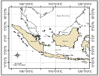
The data used in this study is an ECMWF (European Center for Medium-Range Weather Forecast) ERA-Interim reanalysis Interim data at 00.00 Universal Time Conversion (UTC) last November 2015 to March 2016 in the 92 h.Pa. in the atmospheric layer with spatial resolution 2.50 x 2.50. The parameters used is vertical velocity (vertical motion). MJO Activity will be used the MJO phases record from Bureau of Meteorological Australia website with data period to be ranging from November 2015 until March 2016. Satellite data from TRMM (Tropical rain shower Measuring Mission) is used to view the distribution of precipitation. The region became research area is in the West part of IMC (950- 1200 E 100 S 100 N) which includes the islands of Sumatera, Borneo, and Java (Figure 1).
Figure 1: Western Indonesian maritime continent on 950- 1200E 100 S 100 N.
Borneo vortex is identified with the way saw a counterclockwise circulation in the 925hPa. layer on the area of 2.50S-7.50 N and 102.50-117.50E and at least one wind exceeds 2ms-1 [3]. The phenomenon is observed when the MJO is in the Indonesia maritime continent, namely phases 4 and 5 (the maritime continent), as well as on phases 3 expansion when the MJO is starting to get to the West coast of Sumatera. After identifying the incidence of Borneo vortex and the MJO, then performed in which the incidence of the Borneo vortex without the MJO and the interaction of the Borneo vortex with the MJO on phases 3, 4 and 5 and see its impact on rainfall in the western part of the IMC [9,10].
Result and Discussion
Identification of borneo vortex
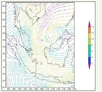
Formation of Borneo vortex happens due to the vorticity which is reproduced by wind shear and reinforced by the northeast monsoon wind convergence with the topography of the island of Borneo [11]. Figure 2 shows one Borneo vortex that is observed. During the period from November until March 2015/2016, there were 19 events of Borneo vortex, which mostly appears in November and March. Meanwhile, the Borneo vortex has the longest period in December (4 days) same with Chang et al. [4].
Figure 2: Wind flow at 925h.Pa. with presenting the Borneo vortex (green box).
Identification of madden-julian oscillation
MJO can be distinguished into 2 conditions, strong and weak/ inactive. Through the phase diagram of the MJO (Figure 3), active MJO conditions identified by the position of the line outside the center (circle), the farther from the center of the circle the more strong intensity of the MJO. When MJO is active in phase 4, it signifies the MJO appear in the western IMC and in phase 5 appear in the eastern IMC. From Figure 3 we can be observed the appearance of strong MJO on phase 3, 4 and 5. During November- December 2015, MJO phenomenon appeared for 33 days and longest occurred in November at phase 4. Meanwhile, in the period January to March 2016, MJO phenomena appear for 35 days with the longest period (9 days appear in phase 4 in February).
Figure 3: MJO diagram phase period October-December 2015 (above) and January-March 2016 (below).

The impact study of MJO and borneo vortex
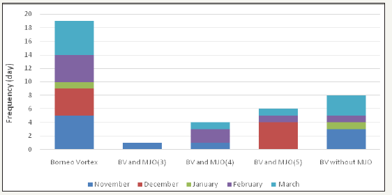
data displayed into a graph will be shown in the Figure 4. Based on Figure 4, the Borneo vortex phenomenon most occur when the inactive MJO on all phase (phase 3, 4 and 5) of 42.10% of the total incidence of the Borneo vortex. The frequency of occurrence of the phenomenon of Borneo vortex at most at a time when strong MJO phase 5 as 6 events (31.57%) and there is a period of Borneo vortex is most long 4 events in December. In otherwise, when active MJO is in phase 3, there is one case of Borneo vortex (5.26%) and in phase 4 there are 4 cases (21.05%). According to Chang et al. [4] the impact of the existence of the MJO is weaken the cold surge that influence to the formation of Borneo vortex so that the frequency of occurrence of Borneo vortex at the moment the MJO is in phase 3 and 4 (Western of IMC) is smaller than when the MJO is strong in phase 5.
Figure 4: Frequency of occurrences Borneo vortex (total), Borneo vortex during MJO phases 3, Borneo vortex during MJO phases 4, Borneo vortex during MJO phases 5 and Borneo vortex without MJO.
By this value of vertical velocity parameter, the movement of air masses surrounding might be found. The cyclonic flow on Borneo vortex system could encourage the upward motion of the warm air mass. This upward motion of the air masses over and commensurate convection might encourage occurrences of the deep convective cloud over large area. In Figure 5, the region of Peninsula Malaysia, Karimata Strait to the South of the island of Borneo, there is a current of rising/upward motion air masses that are strong enough (marked with colors increasingly blue). The smaller the value of vertical speed indicates to be less movement of upward motion. The upward movement of air masses rise will be higher in the center of the vortex.
Figure 5: Frequency of occurrences Borneo vortex (total), Borneo vortex during MJO phases 3, Borneo vortex during MJO phases 4, Borneo vortex during MJO phases 5 and Borneo vortex without MJO.
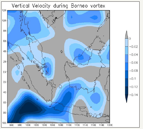
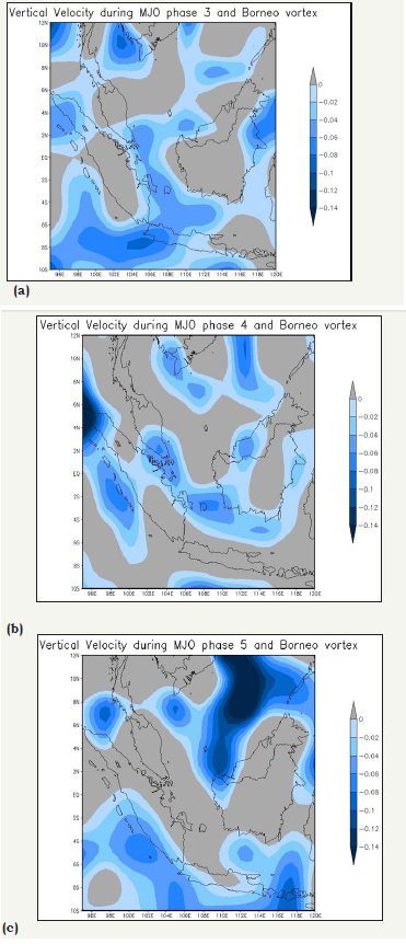
When the Borneo vortex appeared in the period of active MJO, especially in phase 3 and 4, the value of vertical velocity does not indicate the existence of a mass movement of a strong upward air as in genesis Borneo vortex only (Figure 6a-6c). This indicates the intensity of the vortex that is not too strong. Unlike the MJO on phase 5, there is a rising air mass movement in the environment near the center of the vortex (the South China Sea northern Borneo).
Figure 6: Figure 6: Vertical velocity (ms-1) of Borneo vortex during strong MJO on 6a: Phases 3. 6b: Phases 4. 6c: Phases 5.
Rainfall study using TRMM
Based on the rainfall data from TRMM satellite during the occurrence of Borneo vortex without MJO Figure 7 can be known that rainfall at the time of occurrence of Borneo vortex without MJO recorded slight to heavy rain near the vortex occurrence
Figure 7: Rainfall intensity from TRMM’s data (mm) during Borneo vortex without MJO.
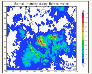
Figure 8: Rainfall data from TRMM’s data (mm) of Borneo vortex during strong MJO in 8a: Phase 3 . 8b: Phase 4. 8c: Phase 5.
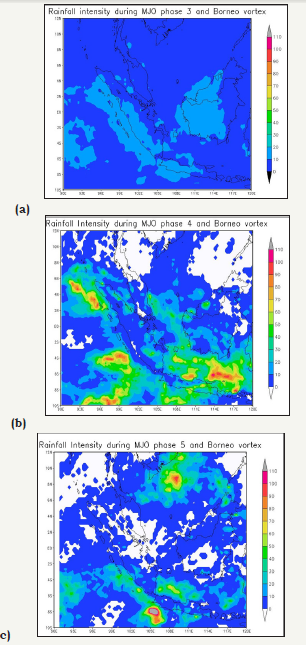
Generally, rainfall is recorded with the intensity of the slight to moderate rain (10-40mm) which includes the western part of Indonesia (Western and southern parts of Kalimantan, Java Sea, the southern part of the Sumatra Island and the western part of Java Island). Recorded data of heavy rain (50-100mm) around the waters of Riau Islands and Bangka Belitung. From Figure 8, there was heavy rain in the Riau Islands and northern Borneo island to the amount of precipitation more than 110mm.
Rainfall is recorded when the occurrence of Borneo vortex without MJO different with the amount of precipitation at the time of occurrence of Borneo vortex which appears simultaneously at the time of active MJO on phase 3. From (Figure 8a-8c) can be known that rain occurred with slight rain (10-20mm) with a wider area coverage of rain (West and South of the island of Borneo as a whole, Western Malaysia, Sumatra and the western part of Java island that extends to the Middle section). While the rainfall data recorded when the occurrence of Borneo vortex appeared concurrently with the active MJO on phase 4, rainfall increased to heavy intensity (10-90mm) with a wider area of coverage again. However, the high intensity of rainfall does not occur in the western part of Borneo, but it occurs at Java Sea and the western part of the island of Sumatra. While the coverage area in Sumatera’s trench narrows with the slight rain. The air mass from southwest of Sumatera met the air mass from northeastern Sumatera. The effect is high rainfall intensity over southern area of IMC. At the time of occurrence of Borneo vortex appeared concurrently with the active MJO on phase 5, heavy rain recorded by region with the center of the vortex in South China Sea and precipitation recorded over 110mm, while in the West area of IMC, the rainfall intensity vary from 20-50mm, which located in the central of the Java Sea.
Conclusion
From this research study can be summarized as follows the highest frequency occurrence of Borneo vortex was during inactive MJO phases 3,4 or 5. MJO may decrease the frequency of Borneo vortex especially during MJO phases 3 and 4. When MJO at phases 5, frequency Borneo Vortex may increasing. Meanwhile, the interaction between MJO and Borneo vortex may enhance the indication of vertical motion as part of the convective process. Based on this study, tell us that the interaction between MJO (in phases 3 and 5) and Borneo vortex may affect the rainfall intensity over western IMC but not so much. The interaction between MJO phases 4 and Borneo vortex may increase rainfall intensity over western IMC.
Acknowledgement
In this study, we thank all those who gave support, especially for the Bureau ofc Meteorology Australia with providing MJO data and information. We also thank Meteorological Climatologically and Geophysical Agency of Indonesia (BMKG) and Indonesian State Collage of Meteorology, Climatology and Geophysics (STMKG) with opportunity to conduct this study
References
- Agita VW (2016) Impact assessment, Asian monsoon interaction, cold surge, and Mjo against atmospheric and bulk dynamics Hujandi Continental Maritime Indonesia. Thesis High School Meteorology Climatology and Geophysics, Jakarta, Indonesia.
- Tangang FT, Juneng L, Salimun E, Vinayachandran PN, Seng YK, et al. (2008) On the roles of the northeast cold surge, the borneo vortex, the madden-julian oscillation, and the Indian ocean dipole mode during the extreme 2006/2007 flood in southern peninsular Malaysia. Geophys Res 35: LI4507
- Anip MHM, Lupo A (2012) Inter annual and Inter decadal variabillity of the borneo vortex during boreal winter monsoon. University of Missouri Columbia USA 1(2): 1-10.
- Chang CP, Harr PA, Chen HJ (2005) Synoptic disturbances over the equatiroal south china sea and western maritime continent during boreal winter. Monthly Weat Rev 1333: 489-503.
- Paulus AW, Shanas SP (2017) Atmospheric study of the impact of cold surge and borneo vortex over western Indonesia maritime continent area. J Climatol Weath Forcesat Rev 5: 1-189.
- Shanas SP (2016) Pengaruh Cold surge dan borneo vortex di benua maritime bagian barat. Skripsi Sekolah Tinggi Meteorologi Klimatologi dan Geofisika, Jakarta, Indonesia.
- Mia V (2017) Kajian Dampak Madden Julian Oscillation (MJO) terhadap curah hujan di beberapa wilayah sumatera. Skripsi Sekolah Tinggi Meteorologi Klimatologi dan Geofisika, Jakarta, Indonesia.
- Holton JR (2004) An Introduction Dynamic meteorology. Elsevier Academic Press USA.
- Ooi SH, Samah AA, Braesicke P (2011) A Case study of the Borneo vortex genesis and its interaction with the global circulaion, J GeophysRev 116: D21116
- Zakir A, Sulistya W, Khotimah MK (2010) Perspektif Operasional Cuaca Tropis, Pusat Penelitian dan Pengembangan BMKG, Jakarta, Indonesia.
- Andarini DF (2012) Analisis cold surge and Borneo vortex menggunakan vortisitas potensial. Institut Teknologi Bandung, Indonesia
© 2018 Paulus Agus Winarso. This is an open access article distributed under the terms of the Creative Commons Attribution License , which permits unrestricted use, distribution, and build upon your work non-commercially.
 a Creative Commons Attribution 4.0 International License. Based on a work at www.crimsonpublishers.com.
Best viewed in


.jpg)


 Editorial Board Registrations
 Submit your Article
 Refer a Friend
 Advertise With Us

.jpg)





.jpg)


.bmp)
.jpg)
.png)
.jpg)


.jpg)


.png)

.png)


.png)


