- Submissions

Full Text
Biodiversity Online J
Earliest Jurassic River Deposits in Northeast Bavaria, Germany
Wolfgang S1*, Johanna HAC2, Stefan S3 and Günter D4
1Former Department of Geology, Heinrich Heine University Düsseldorf, Germany
2Laboratory of Palaeobotany and Palynology, Princetonlaan, Netherlands
3Rosenkrantz-Str. 17, Germany
4Eichbergstr. 25a, Untersteinach
*Corresponding author:Wolfgang Schirmer, Former Department of Geology, Heinrich-Heine University, Düsseldorf, Germany, Address: 91320 Wolkenstein 24, Germany
Submission: June 28, 2023; Published: August 23, 2023

ISSN 2637-7082Volume4 Issue1
Abstract
In northeastern Bavaria/Germany the onset of the Jurassic is indicated by fluvial deposits. Their Jurassic age is proved by paleoflora. The deposits start with a fluvial channel fill composed by fine-grained sandstone and coaly shale containing a small paleofloral assemblage. The streams are draining the slightly higher hinterland of the Bohemian-Variscan Mountains. This channel follows unconformably late Triassic beds of alluvial sheet flows with clayey load and few sandy and muddy channels originating from a mountainous hinterland with subtropical–tropical weathering (Rhaetian Itz Subformation). In contrast to the paleofloral cut at the Triassic/Jurassic boundary the lithologic development does not indicate a severe cut. Only later a change of the relief and the lithology is visible.
Keywords:Boundary Triassic; Jurassic; Jurassic paleoflora; Meandering river; Quartz sandstone
Introduction
Figure 1:Stratigraphical scheme from Feuerletten to Obtusus Clay. Not to scale. Yellow=Forchheim Sandstone, fluviatile and marine. Ammonite Zones (red): an=Angulata Zone, li=Liasicus Zone, pl=Planorbis Zone. W (orange)=Position of the quarry Pechgraben with the Wartholz Channel.
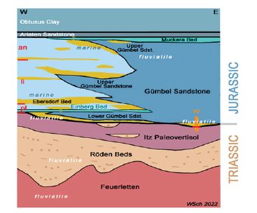
The Triassic/Jurassic boundary in Upper Franconia (Figure 1) is a mere continental boundary. The Upper Triassic is presented by a clay deposited by alluvial sheet flows with clayey load and few sandy and muddy channels originating from a mountainous hinterland with subtropical–tropical weathering. Simultaneously, the sheet flow clay has been remodeled to a paleo-Vertisol [1]. In contrast, the Lower Jurassic has been recorded to start with coarse sand accumulation of rivers from the same hinterland as that of the Triassic period, thus marking a strong unconformity at the Triassic/Jurassic boundary [1-3]. An outcrop close to Bayreuth shows that the earliest exposed Jurassic deposit parallels the Triassic environment demonstrating a river deposit by a channel with fine grained backwater sediments: the so-called Wartholz Channel [1].
Regional Setting
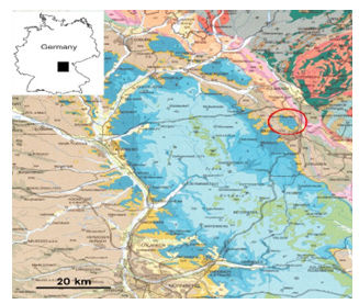
The study area is located (Figure 2) in the Franconian Jura (blue) of northeast Bavaria, namely in the Jurassic outlier, the geographical height of Theta (red circle), which is named after a village. Throughout the Franconian Jurassic, fluviatile Gümbel Sandstone interlocks with marine clays in the Early Jurassic (Hettangian). In the Pechgraben quarry, the rather friable sandstone is mined as sand. The lying Itz paleo-Vertisol strata are also used for clay extraction. The sandstone immediately above the Itz beds is the fluviatile Wartholz Channel, which is discussed in more detail below.
Figure 2:The Location Map shows a part of northeastern Bavaria. Basis map: Geological map of Bavaria 1:500 000, 1996.
Lithostratigraphical Materials
In 2022, the Pechgraben pit exhibited the following section:
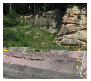
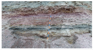
General overview (Figure 3)
Lowest Jurassic, Hettangian (fluvial Bayreuth Formation) ~15m Quartz sandstone, crossbedded (number 3 in Figure 3). 1,70m Wartholz Channel (number 2 in Figure 3): Fine-grained sandstone (Forchheim Sandstone) and bedded clay with organic streaks. Upper Triassic (Rhaetium) fluvial Itz Member of the Rhaetian Exter Formation (number 1 in Figure 3). 6,40m Clay, dark grey, massive, transformed to paleo-Vertisol
Figure 3:Pechgraben quarry. 1=Triassic, Rhaet, paleo-Vertisol of the Itz Member, 2=Jurassic, Wartholz Channel, 3=Jurassic, Gümbel Sandstone.
Details
Section description of the Wartholz Channel. Position 32U 682172, 5542345.
Lower Jurassic
Figure 4:Pechgraben quarry. Hardpan at the base of the coarse Gümbel Sandstone:Coarse quartzsandstone with secondary limonit bands.
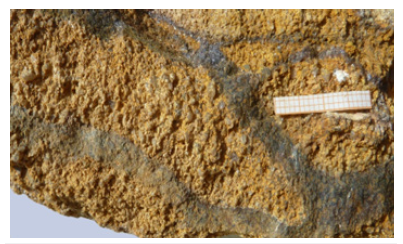
Quartz sandstone, coarse grained, crossbedded, orange yellow, rusty. At its very base, a 0,10m Hardpan layer (Figure 4) Quartz sandstone to conglomerate, grains coarse to medium gravelly (–8,7mm in diameter), well-rounded to angular, grey, and translucent, glassy, very few and small white feldspar, rare muscovite plates, well-sorted, grain supported to matrix supported, intraclasts of fine-grained yellow brown quartz sandstone (Forchheim Sandstone) up to 2,5cm, matrix clayey to silty, yellow brown, to limonitic, brown and darkbrown. Cavities up to 3,5cm from soft intraclasts weathered off, the whole bed crossed by limonite streaks. Wartholz Channel (1,70m) (Figure 5) - 0,80m Shale, clay to silt, with layers up to 4cm thick, grey and brown red to violet red (Munsell Color: 5R 4.5/3.5 and 4.5/4.5) with green lenses, organic coating, small black plant streaks surrounded by white halo, small muscovite plates up to 1mm, non-carbonaceous. - 0,70m Quartz sandstone, bedding up to 5cm thick, fine grained (0.1-0.2mm), rich in muscovite (up to 1,2mm), fine laminated (1-2mm), light and dark grey, organic coating with Otozamites, interstratified by clay lenses rich in organic matter- 0,20m Shale, fine-sandy, in layers up to mm in thickness, greenish grey, with humic dark grey stripes and plant layers, with lenses of fine-grained quartz sandstone up to 3cm in thickness, quartz grains 0.1-0.3mm, matrix supported Triassic/ Jurassic
Figure 5:Pechgraben quarry. Wartholz Channel. A section besides Figure 3, at base with fine-grained sandstone, followed by grey-green, sometimes coaly shale, and topped by red shale that is secondarily altered by fluids.
Upper Triassic
6,40m Claystone, dark grey with coarse polyhedral structure coated by slickensides marking a fossil paleo-Vertisol. From 1.50 down to 4.40m below the upper boundary red clods of clay indicating oxidation clods within the vertical reach of the fluctuating fossil groundwater level [Base of the clay exploitation pit].
Lithostratigraphy Discussion
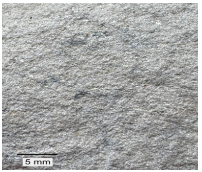
The fine-grained and pelitic Wartholz Channel of Jurassic age indicates an early Jurassic river that marks a quiet environment similar to that in the foregoing Triassic period. A more violent fluvial start suggested by the middle to coarse-grained facies of the Gümbel Sandstone began somewhat later during the early Jurassic. The change of rock colors from colored to grey happened already between the Norian and Rhaetian stage. Thus, there is no sedimentary hint for the distinct paleontological Triassic/Jurassic (T/J) boundary. The reason for the onset of coarser-grained and thick fluvial input somewhat later during Early Jurassic may be land uplift a while after the T/J boundary. Also, sea level subsidence is recorded for the time of T/J boundary as quoted in [4]. The thickness of the Wartholz Channel preserved here with 1,7m was originally somewhat higher. The coarse-grained Gümbel sandstone above has clearly deepened into the central part of its channel, reducing its thickness there. This can be seen from the fact that the rim of the Wartholz Channel rises upward at its edge. At this channel edge, almost only pure fine-grained Forchheim Sandstone is preserved – as a channel edge facies (Figure 6). This edge facies consists of quartz sandstone, grey, fine-grained, 0,1-0,3mm in diameter, max. 0,5mm, muscovite plates up to 1,1mm, well-sorted and matrix-supported (Figure 7). The red coloration in the upper clayey part of the Wartholz Channel is striking (Figure 3 & 5). The region around the geographic height of Theta lies in the Northeast Bavarian Fluid Belt. This shows a narrow tectonic division by faults along which fluids have risen. In the process, rocks with suitable permeability, especially sandstones, were bleached by acidic fluids. The dissolved iron is then deposited outside the bleaching aureole in adjacent rocks, mostly pelites. Thus, a red halo forms around the bleaching aureole [5]. The upper clay of the Wartholz channel is the first pelite to form the edge of the bleaching aureole under the thick sandy body of the coarse Gümbel Sandstone. Hence this pelite shows the conspicuous red coloration. It usually becomes several decimeters thick. Another type of fluid action is the decomposition of the bleached sandstone, which is why it can serve sand mining [5]. The Gümbel Sandstone (Figure 3) of this closer area extends as high as 25m after corings [6]. The basal hardpan of the Gümbel Sandstone (Figure 4) contains mainly coarser grains. Therefore, it is valued here as well-sorted, a sorting embracing the coarse portion of the sand grain scale. This indicates an eluvial sediment in which the finer grain portions are washed off and the heavier portions are concentrated. This eluvial hardpan occurs in several places of northeast Bavaria at the base of the coarser-grained Gümbel Sandstone [1,7]. On the whole, the Wartholz channel shows that Jurassic sedimentation begins with quiet fluviatile movement and fine-grained freight marking a smooth meandering river with oxbow deposits. Thus, the coarse-grained base that is widespread elsewhere is younger than the Wartholz Channel and has eroded the fine-grained sedimentary onset in many places. In the western foreland toward the coast, this fine-grained initial facies of the earliest fluviatile Jurassic can also be expected.
Figure 6:Pechgraben quarry. Fluviatile Wartholz Channel at the Jurassic base. Locality Pechgraben (Figure 2). Fo=Forchheim Sandstone, Gü= Gümbel Sandstone, HP=Hard Pan, Wa=Wartholz Channel filled with Forchheim Sandstone and ±sandy shale, Rhät (Rhaet)=Paleovertisol of the Itz Member (Exter Formation/Triassic). Vertical distance of the Wartholz Channel (Wa) on the right side.
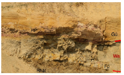
Figure 7:Pechgraben quarry. Wartholz Channel with fine-grained Forchheim Sandstone
Macrofossil Evidence from the Wartholz Channel
So far, we found six different species of fossil plants, a horsetail, three ferns and two Bennettitales. Neocalamites lehmannianus (Göppert) Weber is a horsetail of which only three specimens have so far been encountered in the Wartholz channel (Figure 8). The material consists of some stem fragments that show the typical nodes and internodes plus a specimen with rhizome remains. It must have been a relatively stout horsetail; stems up to 15cm in perimeter have been reported. Long, slender leaves arose from the nodes. When these fall off, they leave small, round scars behind on the nodes. As to its ecology, these plants must probably have grown near or in water. Weber [8] suggested that Neocalamites lehmannianus even grew in moving water, but we have no definite proof for that. This horsetail is a very common species in the Hettangian of Franken (Bavaria), e.g., [8,9], but rare in the Rhaetian. A number of specimens have been found in the Rhaetian Einberg quarry near Coburg, but not in other Rhaetian quarries in Bavaria [10]. In other well-known European Rhaeto-Liassic floras, it is present in some Rhaetian localities and in numerous Hettangian ones (e.g., in the famous Greenland and Sweden floras) [10,11]. Todites princeps (Presl) Gothan is an osmundaceous fern represented by 6 specimens from the Wartholz Channel, one of which is a slab (Figure 9) with a number of remains of this fern plus a specimen of Otozamites brevifolius Braun (see below). The other specimens are smaller fragments although some still occur in larger numbers on one slab. The largest specimen (Figure 10) shows a frond fragment with a 2mm wide rachis and a number of almost perpendicularly attached pinnae. The pinnules are small (3- 4mm long) and have typically a lobed margin. All osmundaceous ferns (fossil and extant) have a rounded to elongate rhizome with the fronds arising from it. As the largest fronds of Todites princeps that have been found so far are some 30cm long arising from a 10cm high rhizome, these ferns might have been some 40cm high. Thus, it was a ground fern and grew in the vicinity of water (near streams or on clay mud surfaces) [8]. Concerning stratigraphy, Todites princeps is a fern that occurred almost worldwide during the early Jurassic or even in some Middle Jurassic localities. But there are a few Rhaetian occurrences albeit outside Europe, e.g., in Japan [12,13]. In Bavaria it is only known from the Hettangian [8,9].
Figure 8:Neocalamites lehmannianus, E333-22.
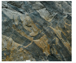
Figure 9:Todites princeps, E287-14.
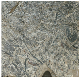
Figure 10:Otozamites brevifolius, E287-14.
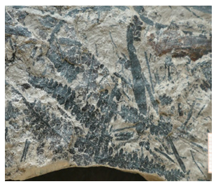
Cladophlebis sp. is another, probably osmundaceous, fern fragment. There is only one tiny sterile specimen (Figure 11) that is too small to attribute to a species. It consists of a 1mm wide rachis with a few alternately inserted pinnules, some 10-12mm long and 5mm wide. They show a clear midrib, but the secondary veins are indistinct. As we only have 1 fragment that cannot be attributed with certainty to a species, this specimen does not have any stratigraphic value. Phlebopteris braunii (Göppert) Hirmer et Hörhammer is by far the commonest fossil plant species in the Wartholz channel; so far 26 specimens were found. It is intriguing that only remains of very young, small, and more or less complete fronds of this matoniaceous fern were found (Figure 12 & 13). Matoniaceous ferns have fronds arising from a creeping rhizome. The fronds have a typical morphology with a longstanding petiole topped by palmately dissected leaf blades (consisting of a number of pinnae) (Figure 12). These pinnae are only up to 5cm long and 1.5cm wide at the most. There is a debate if Phlebopteris braunii is conspecific with Phlebopteris muensteri (Schenk) Hirmer et Hörhammer, one being a sun leaf (P. braunii), the other (P. muensteri) a shade leaf of the same fern. However, the two forms have not always been found together, so for the moment we will keep them apart. Weber [8] also kept the two species separated, and he too recorded those small, young leaves from the Hettangian of the area around Bayreuth. As to the ecology of this fern, it is generally believed to be fern located at the transition between floodplain and lacustrinebackswamp zones [14]. Phlebopteris braunii has been recorded mainly from Liassic localities but it also occurred uncommonly in Middle Jurassic sediments, all in Europe, it was never found in the Rhaetian. In Bavaria, specimens were found in a number of Hettangian localities. Phlebopteris muensteri is species occurring world-wide, from the Rhaetian to the Early Cretaceous. In Bavaria it occurs in almost all Rhaetian and Hettangian localities [8-10,15]. Otozamites brevifolius Braun (the type species of the bennettitalean leaf genus Otozamites) is the second most common plant fossil in the assemblage.
Figure 11:Neocalamites lehmannianus, E333-22.
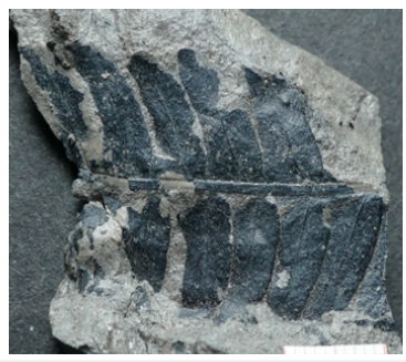
Figure 12:Todites princeps, E287-14.
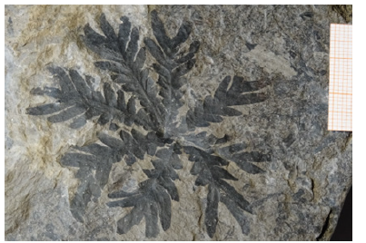
Figure 13:Otozamites brevifolius, E287-14.
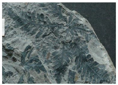
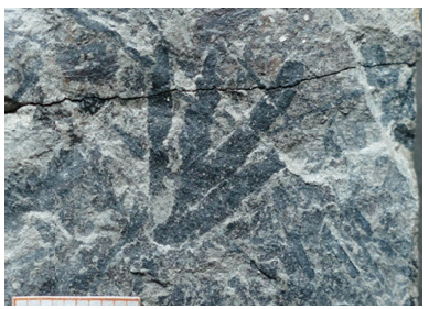
So far 14 specimens have been found the genus Otozamites is characterized by pinnate leaves, the segments of which have an asymmetrical base with an expanded upper part that overlaps the rachis with an ‘auricle’ (Figure 14 & 15). The remains in the Wartholz Channel are relatively large, e.g., an apical leaf fragment (Figure 14) is some 8cm long, and a basal one (Figure 15) measures over 11cm including the leaf base. So complete leaves must have been at least over 20cm long and probably even longer. Bennettitalean leaves were attached to mainly elongated stems, and the plants must have had the size of a bush or small tree some meters high. They probably grew in lowland settings, along riverbanks or near floodplains. Otozamites brevifolius is endemic in Bavaria and remains have only been found in Hettangian sediments, in many localities, esp. in the area around Nuremberg and Bayreuth [8,9]. Pterophyllum angustum (Braun) Gothan is a second bennettitalean species occurring in the Wartholz Channel but so far only two tiny remains have been found one of which could be identified by its cuticle. One (Figure 16) shows three parallel pinnae some 3mm wide (and over 2cm long) with a slightly expanded base and parallel but occasionally forking venation. The other is an even tinier specimen displaying a small apical leaf portion (Figure 17).
Taphonomy indicates that this plant must have grown further away from the locality as we have only a few and small remains. The species is known from the Hettangian of Bavaria, and also from the Hettangian of Sweden and possibly Romania and the Liassic of Iran [9,16]. Concluding one might say that the palaeobotanical evidence points strongly towards a Hettangian age for the Wartholz Channel. The two bennettitalean species (Otozamites brevifolius and Pterophyllum angustum) only occur in the Hettangian; Phlebopteris braunii is also only known from the Hettangian in Bavaria, but if one considers this species conspecific with Phlebopteris muensteri (of which there is no definite proof) then it is also present in the Rhaetian although not as numerous as in the Hettangian. Todites princeps is mainly know from the Hettangian but some Rhaetian occurrences have been mentioned from outside Europe. Finally, Neocalamites lehmannianus is common in the Hettangian but rare in the Rhaetian; but in Bavaria it has been recorded from a Rhaetian locality.
Figure 14:Otozamites brevifolius, E279-14.
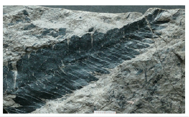
Figure 15:Otozamites brevifolius, E283-14.
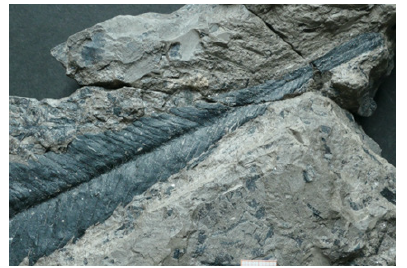
Figure 16:Pterophyllum angustum, E312-14.
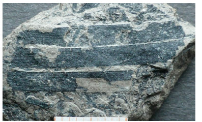
Figure 17:Pterophyllum angustum, E311-14.
Palynological Evidence from the Wartholz Channel
A sample from the Wartholz Channel was taken for palynological analysis at the Laboratory of Palaeobotany and Palynology, University of Utrecht, the Netherlands. It proved to be an example of a typical transition zone with a large amount of malformed palynomorphs. These malformations are an indication of past environmental stress such as heightened UV-B or volcanic eruptions [17]. The sample was rich and consisted for over 90% of smooth trilete spores, often in tetrads or malformed. These spores could in majority be attributed to the dispersed fern spore genera Deltoidospora Miner, Concavisporites Delcourt et Sprumont, Matonisporites Couper, Todisporites Couper and Punctatisporites Ibrahim. Moreover, a few specimens of Trachysporites Nilsson, and Krauselisporites Leschik were present. Pollen was almost absent, with the exception of a few Classopollis Pflug grains. Typical Rhaetian markers such as Rhaetipollis Schulz, Ovalipollis Krutsch, Lunatisporites Leschik and Limbosporites Nilsson have not been found in the sample. The presence of a few Trachysporites specimens indicates a Hettangian age, rather than Rhaetian. But no Cerebropollenites thiergarthii Schulz was found, a pollen species that is considered to be a marker for the earliest Hettangian, e.g., [18-21].
Stratigraphical research based on palynological data is in the centre of interest since the 1980s. Achilles [18] already studied the Rhaetian/Liassic microflora from Franken. Since then, many palynological studies have been carried out on the Triassic/ Jurassic boundary in Europe, e.g., [19-21]. What do all these studies indicate for the stratigraphical age of the Wartholz Channel? As said above, the sample proved to be typical for a transition zone with all its malformed spores. The complete absence of any Rhaetian stratigraphic marker already points towards an earliest Jurassic age for this section; for instance, Rhaetipollis is recorded up to the latest Rhaetian layers in Bavaria [18,21]. Galli [19], Bonis [20], Van de Schootbrugge [22] all record a lowermost Hettangian zone with a large amount of fern spores, often with malformed ones indicating environmental stress. The presence of a few Trachysporites specimens is also typical for the lowermost Jurassic. So, concluding we can state that the palynological evidence points towards an earliest Hettangian age for the Wartholz Channel.
Conclusion
The Gümbel Sandstone is a quartz sandstone defined by fluvial genesis and by Early Jurassic age. Sometimes, the base of the Jurassic period was drawn with the onset of this medium to coarse-grained sandstone. As the Wartholz Channel shows by its paleoflora, the Gümbel Sandstone in its basal part embraces also fine-grained quartz sandstone and shale. Or, in other words, the Triassic/Jurassic boundary is not a facies boundary between finegrained and coarse-grained. A clear facies boundary exists where the Triassic ends with the paleo-Vertisol of the Itz strata [1]. This case is also realized in the Pechgraben outcrop. Otherwise, this paleosol is certainly spatially restricted. Paleogeographically, the Triassic fluviatile plain continues at the time of the Itz strata in the earliest Jurassic, not with paleo-Vertisol, but with gentle slope of the plain towards the coast. The onset of more violent and coarser sandy fill, evidencing a new relief, does not begin until sometime above the Triassic/Jurassic boundary. Palynologically, the Wartholz Channel starts very early in the Hettangian. However, remains, the Triassic/Jurassic boundary can be proved in northeast Bavaria only by the floral incision.
Acknowledgement
We thank dr. B. van de Schootbrugge (University of Utrecht) for his help in confirming the palynological data.
Contribution of Authors
W. Schirmer provided geological field work, elaboration and sampling of the text. S. Schmeissner and G. Dütsch collected paleoflora from the Wartholz Channel. JHA Van Konijnenburg-van Cittert determined and evaluated the paleoflora.
Conflict of Interest
No financial or other conflict of interest exists.
References
- Schirmer W (2020) Rhaetian palaeo-vertisol in upper Franconia/Germany. Zeitschrift der Deutschen Gesellschaft für Geowissenschaften 171: 45-70.
- Krumbeck L (1937) Beiträge zur Geologie von Nordbayern XII. Die Rathsberg-Schichten, das jüngste Glied des Keupers in Franken. Sitzungs-Berichte der physikalisch-medizinischen Sozietät zu Erlangen 36: 15-62.
- Bloos G (1993) Unterer lias im gebiet coburg-lichtenfels-burgkunstadt.
- Bloos G (2021) Die wende trias/jura in: hauschke et al, trias. Aufbruch in das Erdmittelalter 164-176.
- Schirmer W (2018) Creussen Bleaching. Erlanger Beiträge zur Petrographischen Mineralogie 28: 57-63.
- Dobner A, Gilg R, Piewak M, Wagner S, Wamsler S, et al. (2005) Sandsteine und tone der hassberge und des obermaingebietes (rhät-lias und buntsandstein). Erkundung mineralischer Rohstoffe in Bayern 4: 86.
- Schirmer W (2013) Rhät und Unterer Lias nördlich Banz/Oberfranken. Geologische Blätter für Nordost-Bayern 63: 213-244.
- Weber R (1968) Die fossile Flora der Rhät-Lias-Übergangsschichten von Bayreuth (Oberfranken) unter besonderer Berücksichtigung der Coenologie. Erlanger Geologische Abhandlungen 72: 1-73.
- Gothan W (1914) Die unterliassische (rhätische) Flora der Umgegend von Nü Abhandlungen der Naturhistorischen Gesellschaft von Nürnberg 19: 89-186.
- Van Konijnenburg CJHA, Pott C, Schmeissner S, Dütsch G, Kustatscher E (2021) plant macrofossils from the rhaetian of einberg near coburg (Bavaria, Germany). Part 1. Ferns, fern allies and seed ferns. Neues Jahrbuch für Geologie und Palaeontologie 302: 331-353.
- Harris TM (1937) The fossil Flora of Scoresby Sound East Greenland. Part 5. Stratigraphic relations of the plant beds. Meddelelser om Grønland 112: 1-176.
- Harris TM (1961) The Yorkshire Jurassic flora: I. Thallophyta-Pteridophyta. Oxford pp: 212.
- Harris TM (1980) The Yorkshire Jurassic fern Phlebopteris braunii (Göppert) and its reference to Matonia R.Br. Bulletin of the British Museum of Natural History, Geological Series 33 (5): 295-311.
- Barbacka M, Pacyna G, Pienkowski G, Ziaja J (2016) New data about Matonia braunii (Göppert) Harris from the Early Jurassic of Poland and its ecology. Geological Quaterly 60 (4): 857-868.
- Van Konijnenburg JHA, Pott C, Schmeissner S, Dütsch G, Kustatscher E (2020) Ferns and fern allies in the Rhaetian flora of Wüstenwelsberg, Bavaria, Germany. Review of Palaeobotany and Palynology 273: 104147.
- Jung W (1970) Die gothansche rhät/lias-sammlung der naturhistorischen gesellschaft nürnberg. Natur und Mensch Jahresmitteilungen der naturhistorischen Gesellschaft Nürnberg 1970: 63-71.
- Benca JP, Duijnstee IAP, Looy CV (2022) Fossilized pollen malformations as indicators of past environmental stress and meiotic disruption: Insights from modern conifers. Palaeobiology 48 (4): 677-710.
- Achilles H (1981) Die Rätische und Liassische Mikroflora Frankens. Palaeontographica 179: 1-86.
- Galli MT, Jadoul F, Bernasconi SM, Cirilli S, Weissert H (2007) Stratigraphy and palaeoenvironmental analysis of the Triassic-Jurassic transition in the western Southern Alps (Northern Italy). Palaeogeography, Palaeoclimatology, Palaeoecology 244: 52-70.
- Bonis NR, Kürschner WM, Krystyn L (2009) A detailed palynological study of the Triassic-Jurassic transition in key sections of the Eiberg Basin (Northern Calcareous Alps, Austria. Review of Palaeobotany and Palynology 156: 376-400.
- Kürschner WM, Herngreen GFW (2010) Triassic palynology of central and northwestern Europe: A review of palynofloral diversity patterns and biostratigraphic subdivisions. Geological Society London Special Publications 334: 263-283.
- Van De Schootbrugge B, Quan TM, Lindström S, Püttmann W, Heunisch C, et al. (2009) Floral changes across the Triassic/Jurassic boundary linked to flood basalt volcanism. Nature Geoscience 2(8): 589-594.
© 2023 Wolfgang S. This is an open access article distributed under the terms of the Creative Commons Attribution License , which permits unrestricted use, distribution, and build upon your work non-commercially.
 a Creative Commons Attribution 4.0 International License. Based on a work at www.crimsonpublishers.com.
Best viewed in


.jpg)


 Editorial Board Registrations
 Submit your Article
 Refer a Friend
 Advertise With Us
.jpg)


.jpg)


.bmp)
.jpg)
.png)
.jpg)


.jpg)


.png)

.png)


.png)


