- Submissions

Full Text
Biodiversity Online J
Threats to Biodiversity in Australia’s Burdekin River Basin
Eric Wolanski*
TropWater and College of Science and Engineering, James Cook University, Australia
*Corresponding author: Eric Wolanski, TropWater and College of Science and Engineering, James Cook University, Townsville, Queensland, Australia
Submission: February 17, 2021; Published: February 22, 2021

Volume1 Issue3February, 2021
Opinion
The Murray-Darling basin in Australia (Figure 1) is a prime example of a whole river basin
suffering from environmental degradation from historical, haphazard developments without
integrated planning [1]. A similar scenario is developing for the Burdekin River basin in North
Queensland.
The average flow of the Burdekin River is over 40% that of the Murray-Darling. The only
existing large dam on the river is the Burdekin Falls Dam, constructed in 1987; it traps 88%
of the watershed. It provides irrigation water for irrigated sugar farms in the lower Burdekin.
For the environment and biodiversity, the key issues from dams are the impact on the river,
the coast, and the Great Barrier Reef of the dams interfering with the sediment loads and the
runoff from fertilized irrigated farms. There are currently business case studies for raising
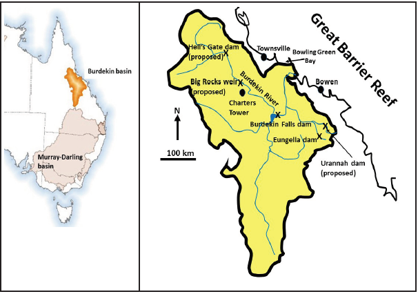
by 2m the Burdekin Falls Dam, and for three new dams (Figure 1): Hells Gates Dam, Urannah
Dam, and the Big Rocks Weir. The Hells Gates and the Urannah dams would double the existing
extraction of water for irrigation.
Figure 1: (Left). A location map of the Murray-Darling and the Burdekin River basins in Australia. (Right). A map of the Burdekin River basin showing the drainage pattern and the dams and weirs.

The EIS for the Burdekin Falls dam predicted that the dam would have good water clarity
and would even improve the clarity of the 159km of river downstream of the dam to the
coast. However, in reality the water behind the dam and all along the river downstream is almost permanently turbid due to limited settling of the suspended
colloidal sediment trapped in the reservoir [2,3]. The proposed
Hells Gates Dam will likely degrade the river similarly for a further
270km. This turbidity affects all aquatic life in the river, including
the vegetation, fish spawning and migration and ability to find food.
During floods, the Burdekin River carries large quantities of
sand [4]. The Burdekin Falls dam captures 95-98% of the sand
that comes in the reservoir, i.e., from 88% of the catchment [5].
The only other sand now carried by the Burdekin River comes
from the small Bowen/Broken tributaries downstream of the dam
[6]. Some of that sand will similarly be trapped in the reservoir if
the Urannah dam is built. All that sand is needed on the coast to
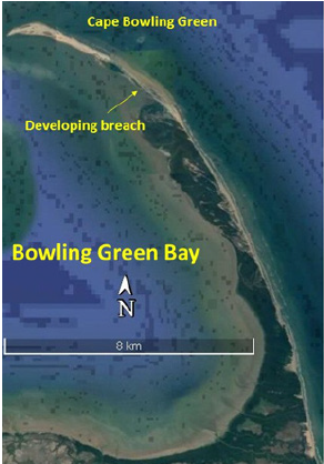
maintain Cape Bowling Green, an 11km long sand peninsula that
protects Bowling Green (Figure 2). This peninsula is maintained by
a balance between new sand coming in with Burdekin River floods
and sand eroded away from the coast by waves and currents all year
long [7,8]. The Burdekin Falls dam is depriving the coast of new
sediment. Satellite and aerial photographs reveal that the peninsula
is eroding away and that it is likely to breach possibly within 10-15
years. This will likely affect the Ramsar-listed wetlands in Bowling
Green Bay. These wetlands protect resident and migratory birds,
and they are also a breeding ground for popular fishing species such
as the ‘mangrove jack’ and ‘barramundi’, and the bay also protects
endangered species of turtle, dugong and juvenile black marlin fish
[9-11]. All this marine life will likely be affected if the Cape Bowling
Green peninsula is breached.
Figure 2:A Google Earth view of Cape Bowling Green peninsula showing the location of the developing breach. Much of the wetlands inside Bowling Green Bay is Ramsar-listed.

Recent research has correlated large flood events of the
Burdekin, and their nutrients (from fertilizers), with coral-eating
Crown-of-Thorns Starfish outbreaks in the Great Barrier Reef [12].
Increased irrigation and increased use of agricultural chemicals
made possible by new dams in the Burdekin basin will accelerate
the degradation of the Great Barrier Reef.
Water allocation for irrigation is a key socio-economic and
environmental issue [13]. There are three mainly sugar cane in
three irrigation areas in the lower Burdekin: the Burdekin Irrigation
Area, the Burdekin Haughton Water System Scheme, and the Delta.
This water has caused the water table, and with it salinization, to
rise from 10m to at some sites 2m below the surface in the last 20
years. Continued rise will undermine the agricultural productivity
of the whole area. Polluted (by fine sediment, NOx, and pesticides)
water from the irrigation areas drains into the wetlands of Bowling
Green Bay and threatens their ecological functioning [14].
Are there solutions to all these problems from new dams so
that the Burdekin basin does not become the Murray-Darling of the
North? The irrigation system in the Lower Burdekin is a basic open
channel system. Irrigation rates could be significantly reduced in
some area by restructuring the architecture of the irrigation system
[15]. The cost would be 2000-8000/ha or something approaching
$300 M for the whole area. This is small in comparison the projected
cost for raising the Burdekin Falls Dam of $1-2B. In addition,
reducing water use would create about the same amount of water,
150,000ML, as raising that dam by 2m. This should be seen not
just as a re-guard action to prevent the salination of the area, but
as an investment to create a highly modern and efficient irrigated
agriculture. The reduction in water would be accompanied by
reduction in agricultural chemicals, and thus a better compliance
with regulations protecting the Great Barrier Reef. For protecting
Cape Bowling Green and Bowling Green Bay, one can be proactive
and invest in erosion protection measures such as sand
replenishment.
Mechanisms for the management the Burdekin Basin
remain inadequate and haphazard. For example, the Queensland
Coordinator General will assess the proposals for the four new
dams in isolation, with no assessment of the cumulative effect-this
is duplicating the mistakes done when developing the Murray-
Darling basin. The Burdekin Water Management Plan can proscribe
each user the volume of water that they can extract but it places
no requirements on water quality and sediment loads and their
impacts on Ramsar-listed sites and the Great Barrier Reef. All these
haphazard development plans for the Burdekin will likely lead to its
degradation, just like that of the Murray-Darling. A shift is needed
when planning the future of Australia’s river systems. One need to
invest in infrastructure that is smart and efficient, that will reduce
excess and waste of our limited water resources, and to sustainably
manage the whole river basin as an ecosystem that includes the
river system, the Great Barrier Reef, and the Bowling Green Bay
Ramsar site.
References
- Hart, B.T., Bond, N.R., Byron, N., Pollino, C.A., Stewardson, M.J. (2021). Murray-Darling Basin, Australia: Its future Management. Elsevier, Amsterdam. 439 pp.
- Burrows, D. W., Faithful, J. F. (2003). From blue to brown: persistently elevated turbidity resulting from damming of the tropical Burdekin River. In ‘Ninth International Conference on River Research and Applications’, 6–11 July 2003, Albury, NSW, Australia. (CRC for Freshwater Ecology.)
- Cooper, M., Lewis, S., Smithers, S.G. (2016). Spatial and temporal dynamics of suspended sediment causing persistent turbidity in a large reservoir: Lake Dalrymple, Queensland, Australia. Marine and Freshwater Research 68, 1377-1390.
- Amos KJ, Alexander J, Horn A, Pocock G, Fielding CR (2004) Supply limited sediment transport in a high‐discharge event of the tropical Burdekin River, North Queensland, Australia. Sedimentology 51(1): 145-162.
- Lewis S, Bainbridge Z, Kuhnert P, Sherman B, Henderson B, et al. (2013) Calculating sediment trapping efficiencies for reservoirs in tropical settings: A case study from the burdekin falls dam, NE Australia. Water Resources Research 49(2): 1017-1029.
- Bainbridge ZT, Lewis S, Smithers S, Kuhnert P, Henderson B, et al. (2014) Fine-suspended sediment and water budgets for a large, seasonally dry tropical catchment: Burdekin River catchment, Queensland, Australia. Water Resources Research 50(11): 9067-9087.
- Pringle A (1983) Sand spit and bar development along the East Burdekin Delta Coast, Queensland, Australia. James Cook University of North Queensland. Monograph series pp 34.
- Pringle AW (2000) Evolution of the east Burdekin Delta coast, Queensland, Australia 1980-1995. Zeitschrift für Geomorphologie 44(3): 273-304.
- Schaffelke, B., Waterhouse, J., Christie, C. (2002). A review of water quality issues influencing the habitat quality in dugong protection areas. Great Barrier Reef Marine Park Authority, Research Publication No. 66, 78 pp.
- Domeier ML, Speare P (2012) Dispersal of adult black marlin (Istiompax indica) from a great barrier reef spawning aggregation. PLoS One 7(2): e31629.
- Milton DA, Driscoll P, Harding S (2014) The importance of Bowling Green Bay and Burdekin River Delta, North Queensland, Australia for shorebirds and waterbirds. Stilt 65(65): 3-16.
- Fabricius K, Okaji K, De'ath G (2010) Three lines of evidence to link outbreaks of the crown-of-thorns seastar Acanthaster planci to the release of larval food limitation. Coral Reefs 29: 593-605.
- Williams J, Stubbs T, Bristow KL (2009) The water and salt balances of the Burdekin River irrigation area. John Williams Scientific Services Pty Ltd pp. 1-37.
- Davis A, Lewis SE, O’Brien DS, Bainbridge ZT, Bentley C, et al. (2014) Water resource developments and high value coastal wetlands on the lower Burdekin floodplain, Australia. pp. 223-245 in Wolanski E. (ed.) ‘Estuaries of Australia in 2050 and Beyond’. Springer, Dordrecht.
- Qureshi, M.E., Wegener, M.K, Harrison, S.R. and Bristow, K.L. (2001), Economic evaluation of alternative irrigation systems for sugarcane in the Burdekin delta in north Queensland, Australia. pp. 47-57 in Brebbia, C.A., Anagnostopoulos, K., Katsifarakis, K., Cheng, A.H.D. (eds.), ‘Water Resource Management’, WIT Press, Boston.
© 2021 Eric Wolanski. This is an open access article distributed under the terms of the Creative Commons Attribution License , which permits unrestricted use, distribution, and build upon your work non-commercially.
 a Creative Commons Attribution 4.0 International License. Based on a work at www.crimsonpublishers.com.
Best viewed in


.jpg)


 Editorial Board Registrations
 Submit your Article
 Refer a Friend
 Advertise With Us
.jpg)


.jpg)


.bmp)
.jpg)
.png)
.jpg)


.jpg)


.png)

.png)


.png)


