- Submissions

Full Text
Aspects in Mining & Mineral Science
Exploration of Old Mining Work Using LiDAR
Gergelova MB1*, Labant S1, Mizak J2 and Pijakova R1
1Institute of Geodesy, Faculty of Mining, Ecology, Technical University of Kosice, Slovakia
2Department of Geofond, State Geological Institute of Dionýz Štúr, Slovakia
*Corresponding author: Marcela Bindzarova Gergelova, Institute of Geodesy, Cartography and Geographical Information Systems, Faculty of Mining, Ecology, Process Control and Geotechnology, Technical University of Kosice, 04200 Kosice, Slovakia
Submission: January 13, 2022;Published: February 24, 2022

ISSN 2578-0255Volume8 Issue5
Abstract
LiDAR is currently the most widely used tool in spatial data collection and is often applied for mapping reliefs and identifying objects. This article reviewed the administration of the register of old mining works and recent mining works in Slovakia. In Slovakia, freely available Aerial Laser Scanning (ALS) products are very useful for geolocation of objects in the Register of Old Mining Works. We used ALS to accurately determine and update their location data, as the state of registration of objects in their current form is unsatisfactory. From this point of view, old mining works represent an important element of cultural and economic development.
Keywords: Old mining works; Geolocation; LiDAR; GIS; DEM; Multidirectional hill-shade
The Register of Old Mining Works and Mining Works
This Register has been under the administration of the State Geological Institute of Dionýz Štúr (SGIDŠ) since its inception. The creation of the Register was connected with the geological tasks carried out by SGIDŠ. The coordination of this activity involving several aspects (e.g., design and processing of the database, creation of map outputs) was entrusted to the Geofond Department. Even after the end of mining activities, some of the preserved objects are still accessed by the public during mountain hiking. It is necessary to recall the traditions of mining activities throughout Slovakia, without which the old mining towns would not have emerged, such as Banská Štiavnica, Kremnica, Rožňava and Gelnica, among others throughout this country. The Register has undergone several changes since its inception, related to innovations in information and communication technology and other technological challenges. The contents of the Register are objects representing historical manifestations of mining activities in Slovakia [1]. Information about them was obtained from reports or archive materials. In principle, these objects were created by mining activities (e.g., adit portals, shafts, pings, mine dumps, tailing ponds). At present, the objects in the Register can represent risks for society (environmental) as well as new opportunities (development of tourism).
LiDAR Data of Selected Locality
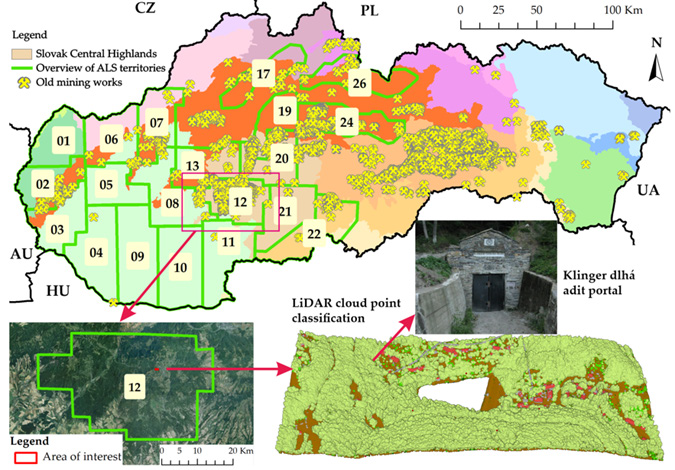
The project of Aerial Laser Scanning (ALS) and its products (orthophoto mosaics and point cloud) are under the administration of the Geodesy, Cartography and Cadastral Authority of the Slovak Republic, and are provided in Slovakia free of charge. One of the products of the ALS project is also a point cloud (available at: https://www.geoportal.sk/en/zbgis/als_dmr/), which is characterized by its parameters (data collection outside the growing season: no snow, haze, rain, etc.; minimum scanning density is 5 points/m2; absolute height accuracy in ETRS89 is mh≤0.15m, absolute positional accuracy in ETRS89-TM34 is mp≤0.30m, two levels of point cloud classification: basic, detailed). Data from the ALS were collected from the locality of the Mining Museum near Banská Štiavnica (Figure 1), where there are also important mining works inscribed in UNESCO’s World Heritage List. As it is assumed that there are also hitherto unregistered mining objects in the locality, so results from the ongoing ALS project are all the more important. The performance of this task required an inventory of existing Register objects in the given area (locality No.12) using the LiDAR, which documented these objects in detail. The minimum requirements for the quality of input data were two to three times more accurate for this locality (mh=0.04m; mp=0.13m). Selecting a suitable site was therefore preceded by considering several criteria (coverage with ALS data, density of mining works, and categories of Register objects in built-up and forested areas).
Figure 1: Location of the mining museum in Slovakia.

Terrain Exploration using LiDAR
Figure 2: LiDAR of Klinger dlhá adit portal.

The solution was based on creating a topographic terrain without vegetation cover, on which the remains of mining activity are present. The classes of *.las files were filtered based on the typological and content structure of the Register. Only three classes of *.las files were processed, those which are usable in the exploration process, i.e., location of Register objects. The objects of shaft type are represented in class 06–building; the other objects are defined in classes 01–unassigned, 02–ground. Then the procedure for processing and analysis of the obtained results was chosen (Figure 2). To display the complexity of the terrain shape, we selected the interpolation method and specified the size of the raster cell (Figure 3). From the range of available interpolation algorithms suitable for DEM creation from the LiDAR [2-4], we chose the recommended and frequently used interpolation method involving binning with IDW cell assignment and filling in the raster’s blank spaces with natural neighbors. In this study was based on also from other studies [5,6] and we set the interpolation on average point spacing a=0.21m in class 02–ground and the size of the selected category of Register objects (e.g., adit portals, size approx. 3x3m). The pixel resolution value which produced the clearest results was a multiple of 0.5 of the average point spacing.
Figure 3: LiDAR processing algorithm for terrain exploration.

Results
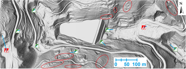
At the Mining Museum, the positions of historically significant Register objects were assessed from two different sources: the Register itself (vector presentation of objects using point geometry), and multidirectional hill-shade (generated from DEM - LiDAR) [7,8]. Comparison showed that the Register did not contain all the old mining works in the locality in question due to the intensity of historical mining activity over the centuries. In this area, it mainly involved pings, i.e., exploratory pits of elliptical shape (usually up to 10 meters in size), which were created during shallow mining activity below the level of the earth’s surface (Figure 4 - in red ellipses). The results of the study were presented based on data generated from LiDAR. The positional coordinates of Register objects were determined from the compared sources, and the positional deviations of ΔP in meters and their azimuth A in degrees were calculated from them. Selected Register objects showed an average positional deviation in the location of 27.89m (Figure 4 - blue lines with the displayed graphic scale).
Figure 4: Areas of occurrence of pings in red ellipses and blue lines of positional deviations Register’s objects.

Differences found in Analysis of the Resulting Outputs
Inaccuracies in positioning and inconsistent information on their dimensions were found in the spatial location data of Register objects, which the following factors could have caused:
a. inconsistent ways of locating above-ground Register
objects in the field, typologically characterized only as a point
(mining works) or line (mining tunnels). For instance, location
of adit portal of collapsed mining corridor; location of area
mining works (mine dumps) using two-dimensional center of
gravity, or center of interface between top and embankment
cone.
b. inaccuracy of topographic maps based on cartographic
generalization during mapping and subsequent creation of the
base map depending on available and actually used display
scales.
c. manual drawing of approximate location of objects in
topographic maps during field surveys with object passports.
d. transformation of topographic maps, digitalization of
approximate locations of identified objects, and their import
into the vector layer of the Register.
Conclusion and Future Development
The mining heritage of each country is precious, and to be valued it must first be identified. The LiDAR technique is already used for various purposes, but this is one of the first studies set up to locate the old mining works in Slovakia with the help of this technique. Although there are no active mining activities in these facilities, they continue to be an important element of the national economy, environment and culture. In this context, there are several important reasons for registering passports for these objects of historical mining activity, a large number of which are abandoned and dilapidated. LiDAR was used for tracing remains of mining activities particularly given the reasonable use of post-mining areas for various purposes by subsequent generations. The study focuses on the duration and range of Slovak experience in mining activity in the past and its inventory, including many mines and other traces visible in the natural environment, and proposes a new approach to investigating old mining works using LiDAR data.
Acknowledgement
This research was funded by the Ministry of Education, Science, Research, and Sport of the Slovakia, grant number KEGA 055TUKE- 4/2021, APVV-18-0351, APVV-20-0281. The authors also thank the Geodesy, Cartography, and Cadastre Authority of the Slovakia for providing the ALS data.
References
- Šoltés S, Kúšik D, Mižák J (2010) Register of old workings and their web-based application. Mineralia Slovaca 42(2): 522-524.
- Guo Q, Li W, Yu H, Alvarez O (2010) Effects of topographie variability and lidar sampling density on several DEM interpolation methods. Photogrammetric Engineering and Remote Sensing 76(6): 701-712.
- Li L, Nearing MA, Nichols MH, Polyakov VO, Phillip GD, et al. (2020) The effects of DEM interpolation on quantifying soil surface roughness using terrestrial LiDAR. Soil Tillage Research 198: 104520.
- Cățeanu M, Ciubotaru A (2021) The effect of lidar sampling density on DTM accuracy for areas with heavy forest cover. Forests 12(3): 265.
- Langridge RM, Ries WF, Farrier T, Barth NC, Khajavi N, et al. (2014) Developing sub-5-m LiDAR DEMs for forested sections of the Alpine and Hope faults, South Island, New Zealand: Implications for structural interpretations. Journal of Structural Geology 64: 53-66.
- Shi W, Deng S, Xu W (2018) Extraction of multi-scale landslide morphological features based on local Gi* using airborne LiDAR-derived DEM. Geomorphology 303: 229-242.
- Veronesi F, Hurni L (2015) A GIS tool to increase the visual quality of relief shading by automatically changing the light direction. Computers & Geosciences 74: 121-127.
- Wang YH, Tseng YH (2015) Raster mapping of topographic parameters derived from high resolution digital elevation models. In Proceedings of the ACRS 2015—36th Asian Conference on Remote Sensing, Fostering Resilient Growth in Asia, Quezon City, Philippines.
© 2022 Gergelova MB. This is an open access article distributed under the terms of the Creative Commons Attribution License , which permits unrestricted use, distribution, and build upon your work non-commercially.
 a Creative Commons Attribution 4.0 International License. Based on a work at www.crimsonpublishers.com.
Best viewed in


.jpg)


 Editorial Board Registrations
 Submit your Article
 Refer a Friend
 Advertise With Us
.jpg)


.jpg)


.bmp)
.jpg)
.png)
.jpg)


.jpg)


.png)

.png)


.png)


