- Submissions

Full Text
Archaeology & Anthropology:Open Access
Morphotectonically Active Basins and Associated ‘Strike-slip Fault Tectonics’ from East Dharwar Craton, Near Sagroli-Simpala Region, Biloli Taluka, Nanded District, Maharashtra, India
Kaplay RD1, Babar MD2* and Aditya Bang1
1 School of Earth Sciences, Swami Ramanand Teerth Marathwada University, India
2 Department of Geology, Dnyanopasak College, India
*Corresponding author: Babar MD, Department of Geology, Dnyanopasak College, Parbhani, Maharashtra, India
Submission: July 02, 2018;Published: October 26, 2018

ISSN: 2577-1949 Volume3 Issue4
Abstract
The present study, carried out around Sagroli-Simpala, Biloli in Nanded district along western margin of East Dharwar Craton (EDC) suggests that the region has dominance of strike-slip fault tectonic regime and the representative sub-basins have experienced tilting. The elongation ratio of the subbasins suggests that the sub-basins are tectonically active. The asymmetry factor of the three sub-basins implies the tectonic tilting of the area.
Introduction
Small displacements in dykes in Precambrian granites reported from Kaddam lineament in Telangana state [1], from western margin of EDC at Sagroli, (Biloli Tahsil, Nanded district) by Banerjee et al. [2], and strike-slip fault tectonics from EDC near Kinwat in Nanded district by Kaplay et al. [3] formed the stimulus to carry out the work in and around the present study area to find out the dominance of fault tectonics of the region. Considering the sporadic research carried out in Sagroli part of the Nanded district, the aim of the present study is to identify the type of tectonic regime and to find out the extent of dominance of tectonic regime along the western margin of EDC and also to find out if sub-basins occurring in the area are tectonically active or not..
Study Area
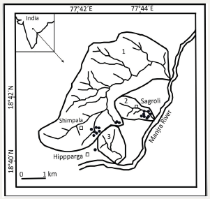
The study area lies between 18°35’ and 18°45’ north latitudes, and 77°40’ and 77°50’ east longitudes (Figure 1). The principal river in the study area is the Manjara. The region is covered by East Dharwar Craton of Archaean to Palaeo-proterozoic age and alluvium of recent to sub-recent age [4-7]. The dominant rock type in the region is Granites, which includes, granitoid and granitic gneiss. Banerjee et al. [8], Banerjee [9] and Wesanekar & Patil [10] called these granites as Nanded Granitoids (NG). These granitioid rocks are intruded by pegmatite veins, quartz veins and isolated basic enclaves. Basaltic rocks are not exposed in the study area. The Deccan trap boundary is 5.6km NW of the study area. Madhnure et al. [11] have reported three major sets of lineaments trending N20°E-S20°W, N30°E-S30°W AND N47 °W-S47 °E in the Nanded district, while Banerjee et al. [12] reported lineaments trending N-S, NNE-SSW, NE-SW, NW-SE and E-W. A major NW-SE trending fault lineament, named as Kaddam fault lineament [13] passes through the adjoining Yavatmal district of Maharashtra [14].
Figure 1:Location map of study area: sub-basin no.1 is Simpala sub-basin, sub-basin no.2 is Sagroli sub-basin and sub-basin no.3 is Hipparga sub-basin. Black solid square in India map is the study area Sagroli in Nanded District, Maharashtra. Solid dots are the sites where deformations are observed. The entire region (white) is covered by granitic rocks of EDC.
Structures
Banerjee et al. [2] have reported minor dislocations in pink feldspar bands in Granite gneiss from Sagroli, Biloli Taluka in Nanded District; however, other detail structural aspects were not reported earlier. The present study gives the details of various structures. Faults: We identified three different types of the small faults in the field including strike-slip fault, normal fault and reverse fault. In addition to these deformations, we also observed the shear zone deformation. Veins have acted as markers. Figure 2 shows quartz vein is displaced at one point in a right-lateral manner. In fact, the fault here is in the form of narrow fault zone having width of 1.5cm. It is a strike-slip fault with dextral sense of shear. In Figure 3, irregular shaped pegamatite vein is displaced at two places in a right-lateral manner. At F4 the displacement is 14 cm, while at F5 it is 19cm.
Figure 2:Quartz vein shows offset at F3 in right-lateral/ dextral manner (horizontal section).
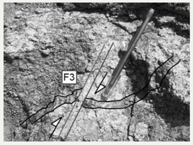
Figure 3:Pegmatite vein shows offset at F4 and F5 in rightlateral/ dextral manner (horizontal section).

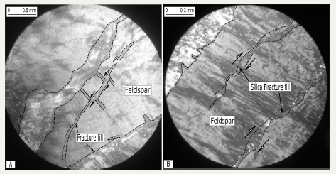
Multiple layering faulting is observed a few places (Figure 4). Three different pegmatite veins are displaced in a sinistral manner at F7-F11. In Figure 5, thin pegmatite vein is displaced at two places in a sinistral manner. At F14 pegmatite vein is displaced in a rightlateral manner (Figure 6). It shows the net slip of 70cm, which is parallel to the strike of the fault with rake as 0°. The fault also shows a small vertical fault scarp with grains arranged in a linear manner (E-W) on the fault plane. The pegmatite vein also shows folding. The thin sections of the sample from fault-scarp are prepared to find out the effect of this strike-slip faulting at microscopic level. The evidence of micro-faulting is also observed in thin section. The thin section of the fault scarp cracks (fracture fill), which are cutting through different mineral (Figure 7A). Secondary minerals occupy these cracks. The fracture fill material is cutting through various minerals indicating its secondary nature. These cracks filled with secondary minerals have displaced the twin lamella of feldspar at some places (Figure 7B). The trend of the strike-slip fault (NE-SW) at mesoscopic level corroborates with the trend of microfault (NESW), the trend of lineations on fault scarp (Figure 8A) and trend of silica fracture fill which shows effect of shearing (Figure 8B). Among the other types of faulting we observed reverse sense of faulting (Figure 9), graben structure (Figure 10) and normal fault (Figure 11).
Figure 4:Three veins show sinsitral type of sense of shear (horizontal section).
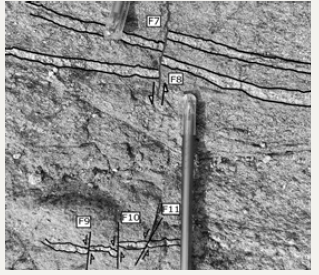
Figure 5:Thin pegmatite vein shows strike-slip faulting with sinistral sense of shear (horizontal section).
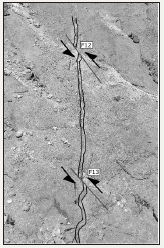
Figure 6:Strike-slip fault with net slip of 70cm, it also show the small vertical fault scarp with lineation (dotted lines) developed on it. Pegmatite vein also shows folding (horizontal section).
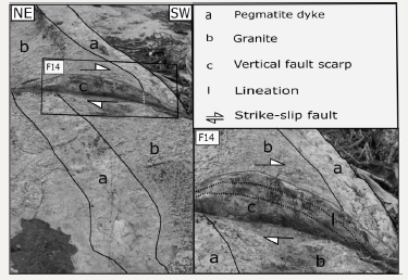
Figure 7:Thin section of the fault scarp (inset of Figure 6) shows secondary filled cracks cutting through the entire thin section.
Figure 7B: These fracture fills have displaced twin lamella at ‘a’ and ‘b’.
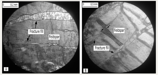
Figure 8:Trend of the microfault matches with the trend of silica fracture fill and strike-slip fault at mesoscopic level in the field.
Figure 8B: The silica fracture fill shows effect of shearing.
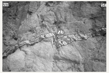
In addition to these fault deformations, shear zones i.e. normal shear zone (Figure 12) and brittle-ductile reverse shear zone (Figure 13) are also observed. Pegmatite vein, at F26, does not display any physical break while another pegmatite vein at F27 displays physical break. In Figure 12, pegmatite vein is displaced in ductile condition. The thickness of the pegmatite vein outside the shear zone at ‘a’ is 5.5cm, at ‘b’ it is 12cm, which is reduced to 2.5cm at ‘c’ inside the shear zone. It is a ‘continuous shear zone’ as the vein has not lost its continuity. In Figure 13, (F28) the pegmatite vein shows reduction in the thickness from 5cm to 2.2cm as it enters the shear zone. The vein pinches out before it is deformed in a brittle manner and ultimately lost its continuity.
Figure 9:Reverse fault with hanging wall moved up (vertical section).
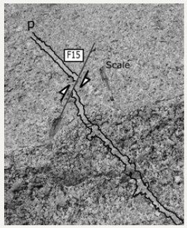
Figure 10:Pegmatite vein ’a’ is displaced at four places viz F18, F19 and F20, while vein ‘b’ is also shows displacement at three places viz F21, F22 and F23. It shows graben like structure at F19 and F20 (vertical section).
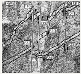
Figure 11:Normal fault with displacement of 7cm and amount of dip as 65° due N5° W (vertical section).
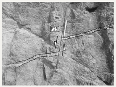
Figure 12:Normal shear zone with pegmatite vein not losing continuity as it passes through the shear zone (vertical section).
Basin Analysis
We selected three representative sub-basins from where deformations are reported with an aim to find out if the sub-basins are tectonically active or not. We have named the sub-basins as follows: sub-basin no.1 as Simpala sub-basin, sub-basin no.2 as Sagroli sub-basin and sub-basin no.3 as Hipparga sub-basin. We determined few morphometric parameters like drainage density, stream frequency, elongation ratio and asymmetric factor. The data is presented in the Table 1. Drainage density of sub-basin no. 1 is 1.50, for sub-basin no. 2 it is 1.74 and for sub-basin no. 3 it is 1.96. The stream frequency for sub-basin no. 1, 2 and 3 are 1.16, 2.10, and 2.10 respectively. The elongation ratio of the three sub-basins are 0.63 (sub-basin no. 1), 0.65 (sub-basin no. 2) and 0.80 (subbasin no. 3). The asymmetric factors for sub-basin no.1, 2 and 3 are 32.96, 61.54 and 13.20 respectively. Figure 14 represents the asymmetric nature of three sub-basins.
Table 1:Morphometric attributes of three sub-basins.

Discussion
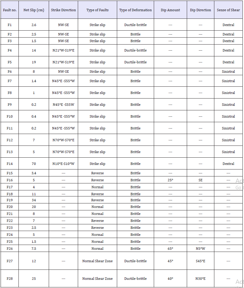
We studied the Sagroli area, located in Biloli Tahsil in Nanded district which is the part of the western margin of South East Deccan Volcanic Province with East Dharwar Craton. The structural field mapping was confined to the EDC. We report faults as the prominent structural feature in the study area. Among the various types of the faults, strike-slip fault’ are dominant (Table 2). The dextral type of sense of movement is dominant in strike-slip faults. The other types of fault movement observed are normal and reverse faults. The minor strike-slip faults, show varying net slip from 0.2cm (F9) to 70cm (F14). Most of the displacements are of brittle type. Ductilebrittle type of displacement in strike-slip faulting is seen at F1, F4, and F5. Strike-slip faulting is predominant with 6 Dextral and 8 cases of Sinistral sense of shear.
The strike-slip faulting reported from the study area is similar to that of the strike-slip faults reported from Kinwat [15] and Kaddam [1], both from ‘East Dharwar Craton’. The dominant strike direction of the strike-slip faults reported from the study area is NW-SE. This direction does not corroborates with the almost E-W trending strike-slip faults reported recently from EDC near Kinwat, which is about 112 km N25°E of the present study area. Earlier, Sangode et al. [1] have reported deformations near Kaddam which is about 125km N70°E of the present study area. Normal continuous shear zone (Figure 12) displays structure that is formed due to shearing by ‘ductile flow’. Such features are expected to be formed at ‘middle and deeper crust’ and reverse shear zone (Figure 13) suggest that the feature is formed by ‘ductile-brittle’ type of deformations, thus at F27, pegmatite vein shows both ‘ductile’ and ‘brittle’ deformation this may be attributed to change in physical conditions systematically during deformation.
It is observed that the faulting, which is reported at mesoscopic level, is also seen at microscopic level (Figure 7,8). The trend of the lineation at mesoscopic level corroborates with that of the trend seen at microscopic level. The cracks, which are filled with secondary minerals, are seen cutting through all the minerals in the slide, thus suggesting its secondary nature. These cracks have displaced twin lamella of feldspar at some places. The trend of lineation at mesoscopic level matches with the trend of cracks at thin section level. Three sub-basins from the study area have been considered to find out whether, the region is tectonically active or not. All the sub-basins show ‘dendritic’ type of drainage pattern (Figure 14).
However, the development of drainages in all these three sub-basins shows typical feature, that in all these three sub-basins, no or very few streams are developed on one side of the highest order of the stream in that particular sub-basin. Sub-basin no.1 shows that only three first order streams are developed towards the right side of the highest order of the stream. In sub-basin no.2, no streams are developed on right side of the highest order of the stream, while in sub-basin no.3 no streams are developed on left side of the highest order of the stream. This is anomalous behavior, which may be attributed to the ‘asymmetric behaviour’ of these three sub-basins.
Figure 13:Brittle-ductile Reverse shear zone (vertical section).
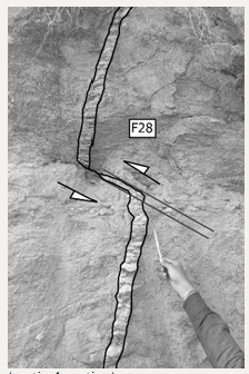
Figure 14:Three sub-basins show asymmetric nature. All the three sub-basins show the effect of an asymmetric factor with a left side tilt on tributaries length in sub-basin no.1 and 2 and absence of tributaries in sub-basin no.3 [16]. Long arrow indicates general slope direction, small arrows indicate direction of tilting of sub-basins.
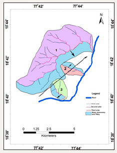
To understand the possible pattern of sub-basin (tectonic) tilting in the study area, asymmetric factor is determined. Asymmetric factor is developed to detect tectonic tilting transverse to flow at drainage sub-basin. All the three sub-basins are asymmetric in nature with ‘asymmetric factor’ as < 50 or >50. Any drainage subbasin with a flowing trunk stream that was subjected to a tectonic rotation will most likely have an effect on the tributaries lengths. In sub-basin no.1 the streams to the right of the main trunk stream are shorter which may be attributed to right dipping due to tectonic activity [16,17]. Thus Sub-basin no.1 is tectonically tilted to right, while sub-basin no. 2 and 3 are tilted to their left. The direction of tilting of sub-basin 1 is SE, for sub-basin no. 2 it is NE and for sub-basin no.3 it is SW. The general slope direction of the region is NE, as the Manjara river flows towards NE. It is interesting to note that the sub-basin no.3 is showing tilting exactly in opposite direction to that of the general slope, sub-basin no.1 shows tilting perpendicular to the general slope and sub-basin no.3 shows tilting in the direction of general slope. Change in the tilting direction of river basins implies periodic neotectonic activities [18]. Change in tilting directions of sub-basins from the study area may also imply periodic neotectonic activities, however, no field evidence of neotectonic deformations are observed from the study area so far. All the evidence of deformations observed in the study area is from ancient granitoid rocks.
Table 2:Types of deformations and other field characters.
It may also be noted that the highest order of the streams in sub-basin no.1 and 2-show sharp knee bend turn (elbow) at a point where it joins the main river. At both the places, the streams almost flow in opposite direction to the general slope direction of the main Manjra River. Both these streams, hence, are off-sequent type of streams. It may be noted that the tilt direction of the subbasin no.1 is SE and the main stream has taken a ninety degree turn towards SE, similarly, the direction of tilting in sub-basin no.3 is SW and main stream has taken a sharp knee-bend turn towards SW direction only. The main streams of all three subbasins follow remarkable straight-line course and main streams of two sub-basins (sub-basin no. 1 and 3) show sharp knee bend turn, there by manifesting tectonic control on the streams. It is further interesting to note that most of the strike-slip faults falling in sub-basin no.1 (F7 to F11), except F3, show NE-SW strike direction. This strike direction matches with the NE-SW trending highest order of the stream in sub-basin no.1. Similarly, most of the strike-slip faults falling in sub-basin no. 2 (F1,F2,F4,F5,F6,F12 and F13), except F14, show NW-SE strike direction. This direction matches with the NW-SE trending highest order of stream in subbasin no.2. Of all the fourteen strike-slip faults, 8 faults show NWSE strike direction while 6 show NE-SW direction. It may be noted that most of the streams, in all the three sub-basins, show NWSE orientation and other streams show NE-SW orientation. This parallelism of the strike NW-SE and NE-SW trend of the strike-slip faults with the alignment of the NW-SE and NE-SW of the streams in three sub-basins cannot be coincidental. Strike-slip movements have probably influenced the drainage development. This indicates the tectonic control on the drainages developed in the region. The dominant deformation styles of NW-SE strike-slip faults suggests that the region has experienced NE-SW compression regime from the strike-slip movement, this direction matches with the NW–SEtrending Urvashi Ghat Lineament in Nanded City [14], which has experienced recently the micro-seismic activity (i.e. 2007 to 2011). Tilting of the basins (neotectonic activity), alignment of the strikeslip faults with the trend of the drainages suggests that neotectonic activity appears to have been controlled by the Precambrian trends of the EDC Granitoid.
The anomalous absence of development of streams or less no. of streams on one side in all the three sub-basins suggests that the region is tectonically tilted. Elongation ratio of < 0.5 indicates that the basin is tectonically active, if it is in between 0.5 and 0.75 the basin is ‘moderately tectonically active’ and if it is >0.75 the basin is ‘inactive basin’ [19]. The elongation ratios of two sub-basins (sub-basin no. 1 and 2) fall in between 0.5 to 0.75, which indicates that these sub-basins are ‘moderately tectonically active’, while the elongation ratio of sub-basin no.3 is 0.80, which indicates that this sub-basin in ‘inactive’. It is to be noted that no deformations are observed in this sub-basin. ‘Short drainage development on one side or no development of drainages on one side’, ‘sharp knee bend of the streams’, ‘asymmetric factor’ of the sub-basins clearly suggests that all these three sub-basins are tectonically active. It is interesting to note that all the structural deformations reported fall in any of these three sub-basins (Figure 1). The region thus hosts remarkable pattern of strike-slip faulting, normal fault, reverse faulting and shear zone, which may suggest that there are different structural blocks although lithology of the region is more or less similar. We further suggest that the area between Sagroli and Kaddam fault may be mapped in detailed from structural and tectonic point of view.
Conclusion
The present study brings out the fact that western margin of East Dharwar Craton, covering the extent of ‘Kinwat-Kaddam- Sagroli’ has witnessed ‘tectonic activities’ in the past and the zone of deformation is extended further SW from Kinwat to Hipparga, near Biloli, Nanded district of Maharashtra. The structural pattern in the basement EDC Nanded Granitoid indicates that this zone is the one where ‘strike-slip movements’ dominated during various events of faulting, including the one at microscopic level, therefore it is concluded that the dominant ‘tectonic regime’ of the region is ‘strike-slip fault tectonics. The representative sub-basins are tilted and tectonically active. However, much more morphometric and Quaternary data needs to be recorded without delay in order to understand the neotectonics of this region in a better way. An integrated approach, involving, geophysical studies, exhaustive studies of younger sediments (Quaternary Deposits) would certainly contribute to understand the tectonics of the region in better way. What is reported in this paper is just an outline of the morphometric and structural studies. The detailed study in this regard is warranted.
Acknowledgement
The authors thank the Director, School of Earth Sciences, Swami Ramanand Teerth Marathwada University, Nanded for his inspiration and constant support during this dissertation work. They express the gratitude towards the Principal and the Head of the Department of Geology, D.S.M. College, Parbhani. We also take an opportunity to thank the Editor for critical comments during the review process.
References
- Sangode SJ, Mesharm DC, Kulkarni YR, Gudadhe SS, Malpe DB, et al. (2013) Neotectonic response of the Godavari and Kaddam rivers in Andhra Pradesh, India: Implications to Quaternary Reactivation of Old Fracture System. J Geol Soc Ind 81(4): 459-471.
- Banerjee R, Shivkumar K, Maithani PB (2012) Major and trace element geochemistry of palaeoproterozoic Nanded district, Maharashtra: Geodynamic and petrogenetic implications. Journal of Applied Geochemistry, pp. 26-58.
- Kaplay RD, Kumar TV, Mukherjee S, Wesanekar PR, Babar M, et al. (2017a) E-W strike slip shearing of Kinwat Granitoid at south east deccan volcanic province, Kinwat, Maharashtra, India. J Earth Sys Sci 126: 71.
- Central Ground Water Board (CGWB) (1998) Ground water exploration in Maharashtra and union territory of Dadra Nagar Haveli., Ministry of Water Resources, Govt of India, India, p. 294.
- Central Ground Water Board (CGWB) (2012) Guidelines for Aquifer Mapping, Govt of India, Faridabad, India, p. 8.
- Ramam BK, Murthy VN (1997) Geology of Andhra Pradesh. Geological Society of India, Bangalore, India, p. 245.
- Raychaudhary JK, Saxena HP, Sinha AK, Sen D (1984) Deccan trap flows in parts of Nanded and Yeotmal Districts Maharashtra: Proc. Geol Surv India Spe Publ 14: 6-8.
- Banerjee R, Veena K, Pandey BK, Parthasarathy TN (1993) Rb-Sr geochronology of the radioactive granites of Nanded area, Maharashtra, India. J Atm Min Sci 1: 111-117.
- Banerjee R (2007) Geological, geochemical and geochronological characterisation of crystallines for Uranium and rare metal and rare earth mineralisation in parts of Nanded district, Maharashtra. RTM, Nagpur University, Nagpur, India.
- Wesanekar PR, Patil RR (2000) Rb-Sr dating of pink Granites of Deglur, Nanded district, Maharashtra, India. In: Proc Nat Sem Tectonomagmatism, Geochemistry and Metamorphism of Precambrian Terrains, pp. 181-187.
- Madhnure P (2014) Groundwater exploration and drilling problems encountered in basaltic and granitic terrain of Nanded District, Maharashtra. Journal Geological Society of India 84: 341-351.
- Banerjee R, Jain SK, Shivkumar K (2008) Geochemistry and petrogenesis of uraninite bearing granitoids and radioactive phosphatic cherty cataclasite of Thadiasoli area, Nanded district, Maharashtra. Memoir Geological Society of India 73: 55-84.
- Banerjee R, Shivkumar K (2010) Geochemistry and petrogenesis of radioactive palaeoproterozoic granitoids of Kinwat crystalline inlier, Nanded, and Yeotmal Districts, Maharashtra. J Geol Soc Ind 75(4): 596- 617.
- Madhnure P, Subramanian PR (1996) Effect of Kadam fault system on the yield of bore wells in parts of Yavatmal district, Maharashtra. Proc of the symposium on Mineral and Groundwater Resources of Vidarbha, Nagpur, India, pp. 243-248
- Kaplay RD, Babar, Mukherjee S, Kumar TV (2017b) Morphotectonic expression of geological structures in eastern part of south east Deccan volcanic province (around Nanded, Maharashtra, India). In: Mukherjee S, Misra AA, Calvès G, Nemčok M (Eds.), Tectonics of the Deccan Large Igneous Province. Geol Soc, London, USA, 445: 317-335.
- Hare PH, Gardner TW (1985) Geomorphic indicators of vertical neotectonism along converging plate margins, Nicoya Peninsula, Costa Rica. In: Morisawa M, Hack JT, (Eds.), Tectonic Geomorphology, Allen and Unwin, Boston, USA, pp. 75-104.
- Keller EA, Pinter N (2002) Active tectonics: Earthquakes, uplift and landscape. Prentice Hall, New Jersey, USA.
- Dhanya V (2014) Basin asymmetry and associated tectonics: A case study of Achankovil river basin, Kerala. Transactions 36(2): 207-215.
- Cuong NQ, Zuchiewicz WA (2001) Morphotectonic properties of the Lo river fault near Tam Dao in North Vietnam. Nat Hazards Earth Syst Sci 1: 115-122.
© 2018 Babar MD. This is an open access article distributed under the terms of the Creative Commons Attribution License , which permits unrestricted use, distribution, and build upon your work non-commercially.
 a Creative Commons Attribution 4.0 International License. Based on a work at www.crimsonpublishers.com.
Best viewed in


.jpg)


 Editorial Board Registrations
 Submit your Article
 Refer a Friend
 Advertise With Us
.jpg)


.jpg)


.bmp)
.jpg)
.png)
.jpg)


.jpg)


.png)

.png)


.png)


